Greeley County, Kansas

Last updated

Greeley County
Greeley County, Kansas courthouse W entrance.JPG
Greeley County Courthouse in Tribune (2010)
Map of Kansas highlighting Greeley County.svg
Location within the U.S. state of Kansas
Kansas in United States.svg
Kansas's location within the U.S.
Coordinates: 38°28′00″N101°49′59″W / 38.4667°N 101.833°W / 38.4667; -101.833
CountryFlag of the United States.svg United States
StateFlag of Kansas.svg  Kansas
FoundedMarch 20, 1873
Named for Horace Greeley
Seat Tribune
Largest cityTribune
Area
  Total778 sq mi (2,020 km2)
  Land778 sq mi (2,020 km2)
  Water0.0 sq mi (0 km2)  0.0%
Population
 (2020) [1]
  Total1,284
  Estimate 
(2021) [2]
1,304 Increase2.svg
  Density1.7/sq mi (0.7/km2)
Time zone UTC−7 (Mountain)
  Summer (DST) UTC−6 (MDT)
Congressional district 1st
Website greeleycounty.org

Greeley County is a county located in western Kansas, in the Central United States. Its county seat and largest city is Tribune. [3] As of the 2020 census, the population was 1,284, [1] making it the least populous county in Kansas. As of 2018, it is tied with Wallace County as the least densely populated county in the state. [4] The county is named after Horace Greeley, [5] editor of the New York Tribune , who encouraged western settlement with the motto "Go West, young man". [6]

Contents

History

Early history

For many millennia, the Great Plains of North America was inhabited by nomadic Native Americans. From the 16th century to 18th century, the Kingdom of France claimed ownership of large parts of North America. In 1762, after the French and Indian War, France secretly ceded New France to Spain, per the Treaty of Fontainebleau.

19th century

In 1802, Spain returned most of the land to France, but Spain kept title to about 7,500 square miles. In 1803, most of the land in modern day Kansas was acquired by the United States from France as part of the 828,000 square mile Louisiana Purchase for 2.83 cents per acre.

In 1854, the Kansas Territory was organized, and Kansas became the 34th U.S. state in 1861. In 1873, Greeley County was established.

Geography

According to the United States Census Bureau, the county has a total area of 778 square miles (2,020 km2), all of which is land. [7] It is the largest of five United States counties and twelve (Virginia) independent cities that officially have no water area.[ citation needed ]

Adjacent counties

Demographics

Population pyramid based on 2000 census age data USA Greeley County, Kansas age pyramid.svg
Population pyramid based on 2000 census age data
Historical population
CensusPop.Note
1890 1,264
1900 493−61.0%
1910 1,335170.8%
1920 1,028−23.0%
1930 1,71266.5%
1940 1,638−4.3%
1950 2,01022.7%
1960 2,0873.8%
1970 1,819−12.8%
1980 1,8451.4%
1990 1,774−3.8%
2000 1,534−13.5%
2010 1,247−18.7%
2020 1,2843.0%
2023 (est.)1,181 [8] −8.0%
U.S. Decennial Census [9]
1790-1960 [10] 1900-1990 [11]
1990-2000 [12] 2010-2020 [1]

As of the census of 2000, there were 1,534 people, 602 households, and 414 families residing in the county. The population density was 2 people per square mile (0.77 people/km2). There were 712 housing units at an average density of 1 per square mile (0.39/km2). The racial makeup of the county was 93.09% White, 0.26% Native American, 0.20% Black or African American, 0.13% Pacific Islander, 0.07% Asian, 5.22% from other races, and 1.04% from two or more races. Hispanic or Latino of any race were 11.54% of the population.

There were 602 households, out of which 34.20% had children under the age of 18 living with them, 61.10% were married couples living together, 4.50% had a female householder with no husband present, and 31.20% were non-families. 28.60% of all households were made up of individuals, and 12.80% had someone living alone who was 65 years of age or older. The average household size was 2.50 and the average family size was 3.10.

In the county, the population was spread out, with 28.20% under the age of 18, 6.80% from 18 to 24, 27.30% from 25 to 44, 19.90% from 45 to 64, and 17.70% who were 65 years of age or older. The median age was 39 years. For every 100 females there were 98.40 males. For every 100 females age 18 and over, there were 92.80 males.

The median income for a household in the county was $34,605, and the median income for a family was $45,625. Males had a median income of $29,018 versus $18,984 for females. The per capita income for the county was $19,974. About 8.20% of families and 11.60% of the population were below the poverty line, including 14.20% of those under age 18 and 6.80% of those age 65 or over.

Government

County

As of January 1, 2009, Greeley County and the City of Tribune have operated as a unified government. [13] The resulting government consists of a five-member commission with two members elected by city residents, two by rural residents, and one at-large. [14] Similar to Wyandotte County, the only other consolidated city-county in the state, part of the county was not included: Horace decided against consolidation. [15]

Presidential elections

This county is often carried by Republican candidates, as are most rural western Kansas counties. The last time a Democratic candidate won the county was in 1976, and a Democratic candidate has only won the county three times in its history: 1932 (Franklin D. Roosevelt), 1964 (Lyndon B. Johnson), and most recently in 1976 by Jimmy Carter.

Presidential election results
United States presidential election results for Greeley County, Kansas [16]
Year Republican Democratic Third party
No.%No.%No.%
2020 54985.65%7812.17%142.18%
2016 53482.15%8312.77%335.08%
2012 54381.04%11316.87%142.09%
2008 59179.33%15120.27%30.40%
2004 58479.46%13818.78%131.77%
2000 62878.21%14317.81%323.99%
1996 56771.95%16120.43%607.61%
1992 50457.73%19121.88%17820.39%
1988 50659.32%31737.16%303.52%
1984 69973.27%22723.79%282.94%
1980 60063.36%23524.82%11211.83%
1976 38943.42%47953.46%283.13%
1972 63968.49%21222.72%828.79%
1968 46559.85%22729.21%8510.94%
1964 38844.80%46954.16%91.04%
1960 64570.57%26228.67%70.77%
1956 59977.09%17422.39%40.51%
1952 72579.06%18119.74%111.20%
1948 39153.34%32644.47%162.18%
1944 37863.00%21535.83%71.17%
1940 49764.55%26834.81%50.65%
1936 39650.45%38849.43%10.13%
1932 35942.64%44052.26%435.11%
1928 43978.25%12121.57%10.18%
1924 35764.21%7513.49%12422.30%
1920 27369.47%9323.66%276.87%
1916 21043.57%16834.85%10421.58%
1912 9535.58%3312.36%13952.06%
1908 20664.58%8927.90%247.52%
1904 14985.63%148.05%116.32%
1900 11875.64%3623.08%21.28%
1896 12160.80%7638.19%21.01%
1892 24167.89%00.00%11432.11%
1888 42259.02%18025.17%11315.80%

Laws

The Kansas Constitution was amended in 1986 to allow the sale of alcoholic liquor by the individual drink with the approval of voters. Greeley County remained a prohibition, or "dry", county until 2008, when voters approved to allow sales of liquor by the drink. [17]

Education

Unified school districts

Communities

2005 map of Greeley County (map legend) Map of Greeley Co, Ks, USA.png
2005 map of Greeley County (map legend)

List of townships / incorporated cities / unincorporated communities / extinct former communities within Greeley County. [18]

Cities

Ghost Towns

Townships

Greeley County was previously divided into three townships. However, in 1992, Colony Township and Harrison Township were merged into Tribune Township, leaving only one township for the county. This was not reported to the U.S. census until 2006, thus the 2000 census did not reflect the merger, but the 2010 census did. [19]

None of the cities within the county are considered governmentally independent, and all figures for the townships include those of the cities. In the following table, the population center is the largest city (or cities) included in that township's population total, if it is of a significant size.

Township FIPS Population
center
PopulationPopulation
density
/km2 (/sq mi)
Land area
km2 (sq mi)
Water area
km2 (sq mi)
Water %Geographic coordinates
Colony 149751720 (0)919 (355)0 (0)0% 38°28′10″N101°55′42″W / 38.46944°N 101.92833°W / 38.46944; -101.92833
Harrison 303251070 (1)511 (197)0 (0)0% 38°21′25″N101°41′14″W / 38.35694°N 101.68722°W / 38.35694; -101.68722
Tribune 71475 Tribune 1,2552 (6)586 (226)0 (0)0% 38°31′51″N101°44′36″W / 38.53083°N 101.74333°W / 38.53083; -101.74333
Sources: "Census 2000 U.S. Gazetteer Files". U.S. Census Bureau, Geography Division. Archived from the original on August 2, 2002.

See also

Community information for Kansas

Related Research Articles

<span class="mw-page-title-main">Wichita County, Kansas</span> County in Kansas, United States

Wichita County is a county located in the U.S. state of Kansas. Its county seat is Leoti. As of the 2020 census, the county population was 2,152. The county was named after the Wichita tribe.

<span class="mw-page-title-main">Wallace County, Kansas</span> County in Kansas, United States

Wallace County is a county located in the U.S. state of Kansas. Its county seat is Sharon Springs. As of the 2020 census, the county population was 1,512, making it the second-least populous county in Kansas. The county was created in 1868 and named in honor of Brigadier General W.H.L. Wallace, who had been mortally wounded in combat in the Battle of Shiloh. Wallace County is home to Mount Sunflower, the highest point in Kansas at 4,039 feet. Mount Sunflower is located approximately 15 miles (24 km) north-northwest of Weskan, less than one mile (1.6 km) from the Colorado state line. It is one of four Kansas counties to use the Mountain Time Zone rather than the Central Time Zone like the remainder of Kansas.

<span class="mw-page-title-main">Trego County, Kansas</span> County in Kansas, United States

Trego County is a county located in the U.S. state of Kansas. Its county seat and largest city is WaKeeney. As of the 2020 census, the county population was 2,808. The county was named for Edgar Trego.

<span class="mw-page-title-main">Thomas County, Kansas</span> County in Kansas, United States

Thomas County is a county located in the U.S. state of Kansas. Its county seat is Colby. As of the 2020 census, the county population was 7,930. The county was named after George Thomas, a general during the American Civil War.

<span class="mw-page-title-main">Stanton County, Kansas</span> County in Kansas, United States

Stanton County is a county located in the U.S. state of Kansas. Its county seat is Johnson City. As of the 2020 census, the county population was 2,084. It was named for Edwin Stanton, the U.S. Secretary of War during most of the American Civil War.

<span class="mw-page-title-main">Rush County, Kansas</span> County in Kansas, United States

Rush County is a county located in the U.S. state of Kansas. Its county seat and largest city is La Crosse. As of the 2020 census, the county population was 2,956. The county was named for Alexander Rush.

<span class="mw-page-title-main">Rawlins County, Kansas</span> County in Kansas, United States

Rawlins County is a county located in the U.S. state of Kansas. Its county seat and largest city is Atwood. As of the 2020 census, the county population was 2,561. It was named after John Rawlins, a general in the American Civil War.

<span class="mw-page-title-main">Phillips County, Kansas</span> County in Kansas, United States

Phillips County is a county located in the U.S. state of Kansas. Its county seat and largest city is Phillipsburg. As of the 2020 census, the county population was 4,981. The county was named after William Phillips, a free-state abolition journalist and colonel in the American Civil War.

<span class="mw-page-title-main">Mitchell County, Kansas</span> County in Kansas, United States

Mitchell County is a county located in the U.S. state of Kansas. Its county seat and largest city is Beloit. As of the 2020 census, the county population was 5,796. The county was named for William Mitchell.

<span class="mw-page-title-main">Lane County, Kansas</span> County in Kansas, United States

Lane County is a county located in the U.S. state of Kansas. Its county seat is Dighton, the only incorporated city in the county. As of the 2020 census, the county population was 1,574, making it the third-least populous county in Kansas. The county was named after James Lane, a leader of the Jayhawker abolitionist movement and served as one of the first U.S. senators from Kansas.

<span class="mw-page-title-main">Kearny County, Kansas</span> County in Kansas, United States

Kearny County is a county located in the U.S. state of Kansas. Its county seat and most populous city is Lakin. As of the 2020 census, the county population was 3,983. The county is named in honor of Philip Kearny, a general during the American Civil War that died during the Battle of Chantilly.

<span class="mw-page-title-main">Jackson County, Kansas</span> County in Kansas, United States

Jackson County is a county in the U.S. state of Kansas. Its county seat and most populous city is Holton. As of the 2020 census, the county population was 13,232. The county, first named Calhoun County for pro-slavery South Carolina Senator John C. Calhoun, was renamed in 1859 for President Andrew Jackson. The Prairie Band Potawatomi Indian Reservation, near the center of the county, comprises about 18.5% of the county's area.

<span class="mw-page-title-main">Hamilton County, Kansas</span> County in Kansas, United States

Hamilton County is a county located in the U.S. state of Kansas. Its county seat and most populous city is Syracuse. As of the 2020 census, the county population was 2,518. The county was founded in 1873 and named for Alexander Hamilton, a founding father of the United States.

<span class="mw-page-title-main">Grant County, Kansas</span> County in Kansas, United States

Grant County is a county located in the U.S. state of Kansas. Its county seat and only city is Ulysses. As of the 2020 census, the county population was 7,352. Both the county and its seat are named after Ulysses Grant, the 18th President of the United States.

<span class="mw-page-title-main">Gove County, Kansas</span> County in Kansas, United States

Gove County is a county in the U.S. state of Kansas. Its county seat is Gove City, and its most populous city is Quinter. As of the 2020 census, the county population was 2,718. The county was named for Granville Gove, a captain of Company G of the 11th Kansas Cavalry Regiment Volunteer Cavalry, who died from battle wounds during the American Civil War.

<span class="mw-page-title-main">Comanche County, Kansas</span> County in Kansas, United States

Comanche County is a county located in the U.S. state of Kansas. Its county seat and most populous city is Coldwater. As of the 2020 census, the county population was 1,689. The county was named after the Comanche tribe.

<span class="mw-page-title-main">Clark County, Kansas</span> County in Kansas, United States

Clark County is a county located in the U.S. state of Kansas. Its county seat and most populous city is Ashland. As of the 2020 census, the county population was 1,991. The county was named after Charles Clarke.

<span class="mw-page-title-main">Anderson County, Kansas</span> County in Kansas, United States

Anderson County is a county located in East Central Kansas, in the Central United States. Its county seat and most populous city is Garnett. As of the 2020 census, the county population was 7,836. The county was named for Joseph C. Anderson, a Kansas territorial legislator and border ruffian during the "Bleeding Kansas" era.

<span class="mw-page-title-main">Horace, Kansas</span> City in Greeley County, Kansas

Horace is a city in Greeley County, Kansas, United States. As of the 2020 census, the population of the city was 102.

<span class="mw-page-title-main">Tribune, Kansas</span> City in Greeley County, Kansas

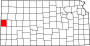
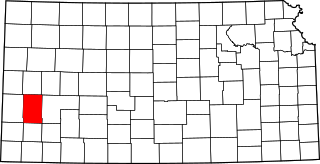
Tribune is a city in and the county seat of Greeley County, Kansas, United States. As of the 2020 census, the population of the city was 772.

References

  1. 1 2 3 "QuickFacts; Greeley County, Kansas; Population, Census, 2020 & 2010". United States Census Bureau. Archived from the original on August 16, 2021. Retrieved August 16, 2021.
  2. "Annual Estimates of the Resident Population for Counties: April 1, 2020 to July 1, 2021" . Retrieved October 3, 2022.
  3. "Find a County". National Association of Counties. Archived from the original on May 31, 2011. Retrieved June 7, 2011.
  4. http://www.ipsr.ku.edu/ksdata/ksah/population/popden2.pdf [ bare URL PDF ]
  5. Gannett, Henry (1905). The Origin of Certain Place Names in the United States. Govt. Print. Off. p. 143.
  6. Josiah Busnell Grinnell (1891). Men and Events of Forty Years. Boston: D. Lothrop. p. 87. ISBN   9780598638700 . Retrieved February 13, 2009.
  7. "US Gazetteer files: 2010, 2000, and 1990". United States Census Bureau. February 12, 2011. Retrieved April 23, 2011.
  8. "Annual Estimates of the Resident Population for Counties: April 1, 2020 to July 1, 2023". United States Census Bureau. Retrieved April 3, 2024.
  9. "U.S. Decennial Census". United States Census Bureau. Retrieved July 24, 2014.
  10. "Historical Census Browser". University of Virginia Library. Retrieved July 24, 2014.
  11. "Population of Counties by Decennial Census: 1900 to 1990". United States Census Bureau. Retrieved July 24, 2014.
  12. "Census 2000 PHC-T-4. Ranking Tables for Counties: 1990 and 2000" (PDF). United States Census Bureau. Archived (PDF) from the original on March 27, 2010. Retrieved July 24, 2014.
  13. "Unified Greeley County, Kansas - Innovative Government - Greeley County, Kansas". greeleycounty.org. February 2012. Retrieved March 3, 2019.
  14. Greeley County residents pass unification Archived March 21, 2009, at the Wayback Machine , Garden City Telegram , November 7, 2007. Accessed November 8, 2007.
  15. TRIBUNE | City and county to unify, The Kansas City Star , November 7, 2007. Accessed November 8, 2007.
  16. "Dave Leip's Atlas of U.S. Presidential Elections". uselectionatlas.org. Retrieved March 3, 2019.
  17. "Map of Wet and Dry Counties". Alcoholic Beverage Control, Kansas Department of Revenue. November 2010. Archived from the original on September 30, 2011. Retrieved August 1, 2011.
  18. 1 2 "General Highway Map of Greeley County, Kansas" (PDF). Kansas Department of Transportation (KDOT). December 2010. Archived (PDF) from the original on October 2, 2023.
  19. Kansas: 2010, Population and Housing unit Counts, pdf p. 21 (2012)
Notes

    Further reading

    County
    Maps

    38°28′N101°50′W / 38.467°N 101.833°W / 38.467; -101.833