Dickinson County is a county in Central Kansas. Its county seat and most populous city is Abilene.[2] As of the 2020 census, the county population was 18,402.[1] The county was named in honor of Daniel Dickinson, a U.S. Senator from New York that was a Kansas statehood advocate.[3]
The first railroad in Dickinson County was built through that territory in 1866.[4]
In 1887, Mr. Herington got the Chicago, Kansas and Nebraska Railway to build through Herington. He gave the land and right-of-way for Herington to become a division point with shops, two round houses, freight house, bridge yards, telegraph office and many other buildings. He furnished the limestone for the freight house, and for a two-story depot that was 28 by 66 feet (8.5m ×20.1m) and later enlarged to 28 by 105 feet (8.5m ×32.0m).[5]
In 2010, the Keystone-Cushing Pipeline (Phase II) was constructed north to south through Dickinson County, with much controversy over tax exemption and environmental concerns.[7][8] A pumping station named Hope was built along the pipeline.
Geography
According to the U.S. Census Bureau, the county has an area of 852 square miles (2,210km2), of which 847 square miles (2,190km2) is land and 4.9 square miles (13km2) (0.6%) is water.[9]
There were 7,903 households, of which 31.10% had children under the age of 18 living with them, 57.90% were married couples living together, 7.70% had a female householder with no husband present, and 31.40% were non-families. 28.10% of households were made up of individuals, and 14.10% had someone living alone who was 65 years of age or older. The average household size was 2.40 and the average family size was 2.94.
In the county, the population was spread out, with 25.70% under the age of 18, 6.30% from 18 to 24, 26.30% from 25 to 44, 23.10% from 45 to 64, and 18.60% who were 65 years of age or older. The median age was 40 years. For every 100 females there were 95.10 males. For every 100 females age 18 and over, there were 91.60 males.
The county's median household income was $35,975, and the median family income was $43,952. Males had a median income of $30,889 versus $18,526 for females. The per capita income in the county was $17,780. About 5.30% of families and 7.50% of the population were below the poverty line, including 8.70% of those under age 18 and 11.30% of those age 65 or over.
Government
Presidential elections
Presidential election results
United States presidential election results for Dickinson County, Kansas[16]
Dickinson County was a prohibition, or "dry", county until the Kansas Constitution was amended in 1986 and voters approved the sale of alcoholic liquor by the individual drink with a 30% food sales requirement.[17]
Dickinson County is divided into twenty-four townships. The cities of Abilene and Herington are considered governmentally independent and are excluded from the census figures for the townships. In the following table, the population center is the largest city (or cities) included in that township's population total, if it is of a significant size.
The Eisenhower Library is in Abilene. In addition to exhibits relating to the life and presidency of the 34th US president, the site is also the location of the tombs of President Eisenhower, First Lady Mamie Eisenhower, and their son who died in infancy.
Notable people
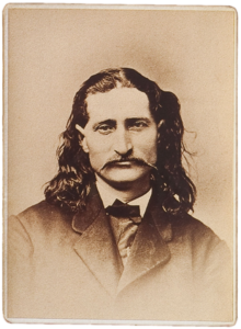
On April 15, 1871, Wild Bill Hickok became marshal of Abilene after its previous marshal was shot and killed.
Clay County is a county located in the U.S. state of Kansas. Its county seat and most populous city is Clay Center. As of the 2020 census, the county population was 8,117. The county was named for Henry Clay, an influential U.S. Senator from Kentucky.
Wabaunsee County is a county located in the U.S. state of Kansas. Its county seat is Alma. As of the 2020 census, the county population was 6,877. The county was named for Chief Waubonsie of the Potawatomi Indians.
Sumner County is a county located in the U.S. state of Kansas. Its county seat is Wellington. As of the 2020 census, the population was 22,382. The county is named after Charles Sumner, a U.S. Senator from Massachusetts who was a leader of Reconstruction politics.
Sedgwick County is located in the U.S. state of Kansas. Its county seat is Wichita, the most populous city in the state. As of the 2020 census, the population was 523,824, making it the second-most populous county in Kansas. The county was named for John Sedgwick, the highest ranking Union general killed during the American Civil War.
Morris County is a county located in the U.S. state of Kansas. Its county seat and largest city is Council Grove. As of the 2020 census, the county population was 5,386. The county was named for Thomas Morris, a U.S. Senator from Ohio and anti-slavery advocate.
McPherson County is a county located in the U.S. state of Kansas. Its county seat and largest city is McPherson. As of the 2020 census, the county population was 30,223. The county was named for James McPherson, a general in the American Civil War.
Marion County is a county located in the U.S. state of Kansas. Its county seat is Marion and its most populous city is Hillsboro. As of the 2020 census, the county population was 11,823. The county was named in honor of Francis Marion, a brigadier general of the American Revolutionary War, known as the "Swamp Fox".
Chase County is a county located in the U.S. state of Kansas. Its county seat and most populous city is Cottonwood Falls. As of the 2020 census, the county population was 2,572. The county was named for Salmon Chase, a U.S. Senator from Ohio that was a Kansas statehood advocate.
Butler County is a county in the U.S. state of Kansas and is the largest county in the state by total area. Its county seat is El Dorado and its most populous city is Andover. As of the 2020 census, the county population was 67,380. The county was named for Andrew Butler, a U.S. Senator from South Carolina who coauthored the Kansas–Nebraska Act.
Abilene is a city in, and the county seat of, Dickinson County, Kansas, United States. As of the 2020 census, the population of the city was 6,460. It is home of The Dwight D. Eisenhower Presidential Library and Museum and the Greyhound Hall of Fame.
Enterprise is a city in Dickinson County, Kansas, United States. As of the 2020 census, the population of the city was 708.
Hope is a city in southern Dickinson County, Kansas, United States. As of the 2020 census, the population of the city was 317.
Manchester is a city in Dickinson County, Kansas, United States. As of the 2020 census, the population of the city was 47.
Lost Springs is a city in Marion County, Kansas, United States. As of the 2020 census, the population of the city was 55. The city was named for a nearby lost spring that was a camping spot along the 19th century Santa Fe Trail. It is located south of Herington, about 0.6 miles west of the intersection of U.S. Route 77 highway and 340th Street next to the Union Pacific Railroad.
Ramona is a city in Marion County, Kansas, United States. As of the 2020 census, the population of the city was 78. The city name is a Spanish name. It is located southwest of Herington next to a railroad.
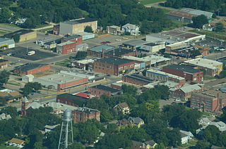
Herington is a city in Dickinson and Morris counties in the U.S. state of Kansas. As of the 2020 census, the population of the city was 2,109.
Willard is a city in Shawnee and Wabaunsee counties in the State of Kansas in the United States. As of the 2020 census, the population of the city was 74.
Talmage is an unincorporated community in Dickinson County, Kansas, United States. As of the 2020 census, the population of the city was 78.
Navarre is an unincorporated community in Dickinson County, Kansas, United States. As of the 2020 census, the population of the city was 52.
Burdick is an unincorporated community in Morris County, Kansas, United States. It was named after Ms. Burdick, the sweetheart of a Santa Fe Railroad official in 1887. As of the 2020 census, the population of the community and nearby areas was 62. It is located southeast of Herington, about 5.6 miles (9.0 km) east of the intersection of U.S. Route 77 highway and 340th Street, or about 6.5 miles (10.5 km) east of Lost Springs.
↑ "Map of Wet and Dry Counties". Alcoholic Beverage Control, Kansas Department of Revenue. November 2006. Archived from the original on October 8, 2007. Retrieved December 28, 2007.
This page is based on this Wikipedia article Text is available under the CC BY-SA 4.0 license; additional terms may apply. Images, videos and audio are available under their respective licenses.