Paxico, Kansas

Last updated

Paxico, Kansas
Paxico kansas 2009.jpg
Old railroad depot in Paxico (2009)
Wabaunsee County Kansas Incorporated and Unincorporated areas Paxico Highlighted.svg
Location within Wabaunsee County and Kansas
Map of Wabaunsee Co, Ks, USA.png
Coordinates: 39°04′08″N96°10′01″W / 39.06889°N 96.16694°W / 39.06889; -96.16694 [1]
Country United States
State Kansas
County Wabaunsee
Founded1879
Incorporated 1914 [2]
Named for Pashqua
Government
[2]
  Type Mayor–Council
Area
[3]
  Total0.14 sq mi (0.38 km2)
  Land0.14 sq mi (0.38 km2)
  Water0.00 sq mi (0.00 km2)
Elevation
[1]
991 ft (302 m)
Population
 (2020) [4]
  Total210
  Density1,500/sq mi (550/km2)
Time zone UTC-6 (CST)
  Summer (DST) UTC-5 (CDT)
ZIP code
66526
Area code 785
FIPS code 20-54950
GNIS ID 2396166 [1]

Paxico is a city in Wabaunsee County, Kansas, United States. [1] As of the 2020 census, the population of the city was 210. [4]

Contents

History

Main Street in Paxico, 1901 Paxico, Kansas (1901).jpg
Main Street in Paxico, 1901

Paxico was originally called Strong Mill, and under this former name was established in 1879 about one mile east of the present town site. [5] A post office was set up and named Paxico, in honor of the Potawatomi medicine man Pashqua. [5] [6] [7] When the railroad was built though the area in 1886, the town moved in order to be alongside it. [5]

In 1887, the Chicago, Kansas and Nebraska Railway built a main line from Topeka through Paxico to Herington. [8] The Chicago, Kansas and Nebraska Railway was foreclosed in 1891 and taken over by Chicago, Rock Island and Pacific Railway, which shut down in 1980 and reorganized as Oklahoma, Kansas and Texas Railroad, merged in 1988 with Missouri Pacific Railroad, merged in 1997 with Union Pacific Railroad. Most locals still refer to this railroad as the "Rock Island".

Geography

According to the United States Census Bureau, the city has a total area of 0.14 square miles (0.36 km2), all of it land. [9]

Demographics

Historical population
CensusPop.Note
1920 249
1930 2614.8%
1940 237−9.2%
1950 196−17.3%
1960 27640.8%
1970 216−21.7%
1980 168−22.2%
1990 1743.6%
2000 21121.3%
2010 2214.7%
2020 210−5.0%
U.S. Decennial Census

Paxico is part of the Topeka Metropolitan Statistical Area.

2020 census

The 2020 United States census counted 210 people, 81 households, and 55 families in Paxico. [10] [11] The population density was 1,448.3 per square mile (559.2/km2). There were 89 housing units at an average density of 613.8 per square mile (237.0/km2). [11] [12] The racial makeup was 86.67% (182) white or European American (84.76% non-Hispanic white), 0.48% (1) black or African-American, 0.0% (0) Native American or Alaska Native, 0.0% (0) Asian, 0.0% (0) Pacific Islander or Native Hawaiian, 2.86% (6) from other races, and 10.0% (21) from two or more races. [13] Hispanic or Latino of any race was 8.57% (18) of the population. [14]

Of the 81 households, 37.0% had children under the age of 18; 50.6% were married couples living together; 25.9% had a female householder with no spouse or partner present. 23.5% of households consisted of individuals and 12.3% had someone living alone who was 65 years of age or older. [11] The average household size was 2.5 and the average family size was 3.3. [15] The percent of those with a bachelor’s degree or higher was estimated to be 21.4% of the population. [16]

25.2% of the population was under the age of 18, 11.9% from 18 to 24, 17.6% from 25 to 44, 27.1% from 45 to 64, and 18.1% who were 65 years of age or older. The median age was 40.7 years. For every 100 females, there were 105.9 males. [11] For every 100 females ages 18 and older, there were 109.3 males. [11]

The 2016-2020 5-year American Community Survey estimates show that the median household income was $35,000 (with a margin of error of +/- $11,935) and the median family income was $46,667 (+/- $30,062). [17] Females had a median income of $20,278 (+/- $9,260). The median income for those above 16 years old was $25,469 (+/- $2,629). [18] Approximately, 3.2% of families and 7.1% of the population were below the poverty line, including 12.3% of those under the age of 18 and 3.5% of those ages 65 or over. [19] [20]

2010 census

As of the census [21] of 2010, there were 221 people, 85 households, and 58 families residing in the city. The population density was 1,578.6 inhabitants per square mile (609.5/km2). There were 93 housing units at an average density of 664.3 per square mile (256.5/km2). The racial makeup of the city was 91.0% White, 1.8% African American, 0.5% Native American, and 6.8% from two or more races. Hispanic or Latino of any race were 5.4% of the population.

There were 85 households, of which 35.3% had children under the age of 18 living with them, 54.1% were married couples living together, 5.9% had a female householder with no husband present, 8.2% had a male householder with no wife present, and 31.8% were non-families. 24.7% of all households were made up of individuals, and 7.1% had someone living alone who was 65 years of age or older. The average household size was 2.60 and the average family size was 3.00.

The median age in the city was 36.3 years. 28.5% of residents were under the age of 18; 6.3% were between the ages of 18 and 24; 26.3% were from 25 to 44; 25.7% were from 45 to 64; and 13.1% were 65 years of age or older. The gender makeup of the city was 51.1% male and 48.9% female.

2000 census

As of the census [22] of 2000, there were 211 people, 82 households, and 55 families residing in the city. The population density was 1,501.9 inhabitants per square mile (579.9/km2). There were 90 housing units at an average density of 640.6 per square mile (247.3/km2). The racial makeup of the city was 94.31% White, 0.95% African American, 0.95% from other races, and 3.79% from two or more races. Hispanic or Latino of any race were 5.21% of the population.

There were 82 households, out of which 31.7% had children under the age of 18 living with them, 53.7% were married couples living together, 9.8% had a female householder with no husband present, and 32.9% were non-families. 29.3% of all households were made up of individuals, and 14.6% had someone living alone who was 65 years of age or older. The average household size was 2.57 and the average family size was 3.22.

In the city, the population was spread out, with 29.4% under the age of 18, 7.6% from 18 to 24, 27.5% from 25 to 44, 22.3% from 45 to 64, and 13.3% who were 65 years of age or older. The median age was 34 years. For every 100 females, there were 102.9 males. For every 100 females age 18 and over, there were 101.4 males.

The median income for a household in the city was $41,250, and the median income for a family was $45,000. Males had a median income of $38,750 versus $26,250 for females. The per capita income for the city was $14,274. About 5.8% of families and 10.3% of the population were below the poverty line, including 9.5% of those under the age of eighteen and 8.7% of those 65 or over.

Education

The community is served by Wabaunsee USD 329 public school district. USD 329 was formed by school unification that consolidated Alma, Maple Hill, McFarland, and Paxico. Wabaunsee High School is located in Alma. The Wabaunsee High School mascot is Wabaunsee Chargers. [23]

Paxico High School was closed through school unification. The Paxico High School mascot was Paxico Pirates. [24]

Area events

Related Research Articles

<span class="mw-page-title-main">Isabel, Kansas</span> City in Kiowa County, Kansas

Isabel is a city in Barber County, Kansas, United States. As of the 2020 census, the population of the city was 68.

<span class="mw-page-title-main">Powhattan, Kansas</span> City in Brown County, Kansas

Powhattan is a city in Brown County, Kansas, United States. As of the 2020 census, the population of the city was 69.

<span class="mw-page-title-main">Glasco, Kansas</span> City in Cloud County, Kansas

Glasco is a city in Cloud County, Kansas, United States. As of the 2020 census, the population of the city was 441.

<span class="mw-page-title-main">Waverly, Kansas</span> City in Coffey County, Kansas

Waverly is a city in Coffey County, Kansas, United States. As of the 2020 census, the population of the city was 574.

<span class="mw-page-title-main">Hepler, Kansas</span> City in Crawford County, Kansas

Hepler is a city in Crawford County, Kansas, United States. As of the 2020 census, the population of the city was 90.

<span class="mw-page-title-main">Norcatur, Kansas</span> City in Decatur County, Kansas

Norcatur is a city in Decatur County, Kansas, United States. As of the 2020 census, the population of the city was 159.

<span class="mw-page-title-main">Gove City, Kansas</span> City in Gove County, Kansas

Gove City, more commonly known as Gove, is a city in and the county seat of Gove County, Kansas, United States. As of the 2020 census, the population of the city was 80.

<span class="mw-page-title-main">Hoyt, Kansas</span> City in Jackson County, Kansas

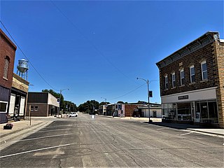
Hoyt is a city in Jackson County, Kansas, United States. As of the 2020 census, the population of the city was 593.

<span class="mw-page-title-main">Randall, Kansas</span> City in Jewell County, Kansas

Randall is a city in Jewell County, Kansas, United States. As of the 2020 census, the population of the city was 79.

<span class="mw-page-title-main">Edgerton, Kansas</span> City in Kansas, United States

Edgerton is a city in Johnson County, Kansas, United States, and part of the Kansas City metropolitan area. As of the 2020 census, the population of the city was 1,748. It is home to a large BNSF intermodal train facility named Logistics Park Kansas City.

<span class="mw-page-title-main">Kingman, Kansas</span> City in Kingman County, Kansas

Kingman is a city in and the county seat of Kingman County, Kansas, United States. As of the 2020 census, the population of the city was 3,105.

<span class="mw-page-title-main">Ness City, Kansas</span> City in Ness County, Kansas

Ness City is a city in and the county seat of Ness County, Kansas, United States. As of the 2020 census, the population of the city was 1,329. Ness City is famous for its four-story Old Ness County Bank Building located downtown, and nicknamed Skyscraper of the Plains.

<span class="mw-page-title-main">Belleville, Kansas</span> City in Republic County, Kansas

Belleville is a city in and the county seat of Republic County, Kansas, United States. As of the 2020 census, the population of the city was 2,007.

<span class="mw-page-title-main">Mount Hope, Kansas</span> City in Sedgwick County, Kansas

Mount Hope is a city in Sedgwick County, Kansas, United States. As of the 2020 census, the population of the city was 806.

<span class="mw-page-title-main">Alma, Kansas</span> City in Wabaunsee County, Kansas

Alma is a city in and the county seat of Wabaunsee County, Kansas, United States. As of the 2020 census, the population of the city was 802.

<span class="mw-page-title-main">Alta Vista, Kansas</span> City in Wabaunsee County, Kansas

Alta Vista is a city in Wabaunsee County, Kansas, United States. As of the 2020 census, the population of the city was 409.

<span class="mw-page-title-main">Eskridge, Kansas</span> City in Wabaunsee County, Kansas

Eskridge is a city in Wabaunsee County, Kansas, United States. As of the 2020 census, the population of the city was 439.

<span class="mw-page-title-main">Maple Hill, Kansas</span> City in Wabaunsee County, Kansas

Maple Hill is a city in Wabaunsee County, Kansas, United States. As of the 2020 census, the population of the city was 631.

<span class="mw-page-title-main">McFarland, Kansas</span> City in Wabaunsee County, Kansas

McFarland is a city in Wabaunsee County, Kansas, United States. As of the 2020 census, the population of the city was 272.

<span class="mw-page-title-main">Newbury, Kansas</span> Unincorporated community in Wabaunsee County, Kansas

Newbury is an unincorporated community in Wabaunsee County, Kansas, United States. As of the 2020 census, the population of the community and nearby areas was 78. It is located approximately 2 miles northwest of Paxico.

References

  1. 1 2 3 4 U.S. Geological Survey Geographic Names Information System: Paxico, Kansas
  2. 1 2 "City of Paxico". The League of Kansas Municipalities. May 28, 2019.
  3. "2019 U.S. Gazetteer Files". United States Census Bureau. Retrieved July 24, 2020.
  4. 1 2 "Profile of ?, Kansas in 2020". United States Census Bureau. Archived from the original on May 14, 2022. Retrieved May 14, 2022.
  5. 1 2 3 Blackmar, Frank Wilson (1912). Kansas: A Cyclopedia of State History, Volume 2. Standard Publishing Company.
  6. Heim, Michael (2007). Exploring Kansas Highways. p. 42. ISBN   9780974435886.
  7. "Profile for Paxico, Kansas". ePodunk . Retrieved June 27, 2014.
  8. "Rock Island Rail History". Archived from the original on June 19, 2011. Retrieved April 18, 2011.
  9. "US Gazetteer files 2010". United States Census Bureau. Archived from the original on January 12, 2012. Retrieved July 6, 2012.
  10. "US Census Bureau, Table P16: HOUSEHOLD TYPE". data.census.gov. Retrieved January 3, 2024.
  11. 1 2 3 4 5 "US Census Bureau, Table DP1: PROFILE OF GENERAL POPULATION AND HOUSING CHARACTERISTICS". data.census.gov. Retrieved January 3, 2024.
  12. Bureau, US Census. "Gazetteer Files". Census.gov. Retrieved December 30, 2023.
  13. "US Census Bureau, Table P1: RACE". data.census.gov. Retrieved January 3, 2024.
  14. "US Census Bureau, Table P2: HISPANIC OR LATINO, AND NOT HISPANIC OR LATINO BY RACE". data.census.gov. Retrieved January 3, 2024.
  15. "US Census Bureau, Table S1101: HOUSEHOLDS AND FAMILIES". data.census.gov. Retrieved January 3, 2024.
  16. "US Census Bureau, Table S1501: EDUCATIONAL ATTAINMENT". data.census.gov. Retrieved January 3, 2024.
  17. "US Census Bureau, Table S1903: MEDIAN INCOME IN THE PAST 12 MONTHS (IN 2020 INFLATION-ADJUSTED DOLLARS)". data.census.gov. Retrieved January 3, 2024.
  18. "US Census Bureau, Table S2001: EARNINGS IN THE PAST 12 MONTHS (IN 2020 INFLATION-ADJUSTED DOLLARS)". data.census.gov. Retrieved January 3, 2024.
  19. "US Census Bureau, Table S1701: POVERTY STATUS IN THE PAST 12 MONTHS". data.census.gov. Retrieved January 3, 2024.
  20. "US Census Bureau, Table S1702: POVERTY STATUS IN THE PAST 12 MONTHS OF FAMILIES". data.census.gov. Retrieved January 3, 2024.
  21. "U.S. Census website". United States Census Bureau . Retrieved July 6, 2012.
  22. "U.S. Census website". United States Census Bureau . Retrieved January 31, 2008.
  23. "Wabaunsee USD 329". USD 329. Retrieved January 4, 2017.
  24. "Playoffs Move to Semifinals", The Emporia Gazette, 15 November 1973, p.5.
  25. "フランス産の美味しいロゼワインまとめ♪". June 12, 2018.
  26. Paxico Blues Fest

Further reading