
Wabaunsee County is a county located in the U.S. state of Kansas. Its county seat is Alma. As of the 2020 census, the county population was 6,877. The county was named for Chief Waubonsie of the Potawatomi Indians.

Shawnee County is located in northeast Kansas, in the central United States. Its county seat and most populous city is Topeka, the state capital. As of the 2020 census, the population was 178,909, making it the third-most populous county in Kansas. The county was one of the original 33 counties created by the first territorial legislature in 1855, and it was named for the Shawnee tribe.

Riley County is a county located in the U.S. state of Kansas. Its county seat and largest city is Manhattan. As of the 2020 census, the population was 71,959. The county was named after Bennet Riley, the 7th governor of California, and a Mexican–American War hero. Riley County is home to Fort Riley and Kansas State University.

Pottawatomie County is a county located in the U.S. state of Kansas. Its county seat is Westmoreland. As of the 2020 census, the county population was 25,348. The county was named for the Potawatomi tribe.

Osage County is a county located in the U.S. state of Kansas. Its county seat is Lyndon, and its most populous city is Osage City. As of the 2020 census, the county population was 15,766. The county was originally organized in 1855 as Weller County, then renamed in 1859 after the Osage tribe.

Morris County is a county located in the U.S. state of Kansas. Its county seat and largest city is Council Grove. As of the 2020 census, the county population was 5,386. The county was named for Thomas Morris, a U.S. Senator from Ohio and anti-slavery advocate.

Geary County is a county located in the U.S. state of Kansas. Its county seat and most populous city is Junction City. As of the 2020 census, the county population was 36,739. The county is named in honor of John Geary, the first mayor of San Francisco, a governor of the Kansas Territory, and the 16th governor of Pennsylvania.

Doniphan County is the most northeastern county in the U.S. state of Kansas. Its county seat is Troy, and its most populous city is Wathena. As of the 2020 census, the county population was 7,510. The county was named after Alexander Doniphan, a Mexican–American War hero. It is bounded on the east by the Missouri river, south by Atchison county, and west by Brown county.

Louisville is a city in Pottawatomie County, Kansas, United States. As of the 2020 census, the population of the city was 131.

Lamy is a census-designated place (CDP) in Santa Fe County, New Mexico, United States, 18 miles (29 km) south of the city of Santa Fe. The community was named for Archbishop Jean-Baptiste Lamy, and lies within the Bishop John Lamy Spanish Land Grant, which dates back to the eighteenth century.

Wilberforce is a census-designated place (CDP) in Greene County, Ohio, United States. The population was 2,410 at the 2020 census.
Tecumseh is an unincorporated community in Shawnee County, Kansas, United States, and situated along the Kansas River. As of the 2020 census, the population of the community and nearby areas was 696. The community and township are both named for the Shawnee chief.

Bendena is an unincorporated community in Doniphan County, Kansas, United States. As of the 2020 census, the population of the community and nearby areas was 117.

Talmage is an unincorporated community in Dickinson County, Kansas, United States. As of the 2020 census, the population of the city was 78.

K-99 is a state highway in the U.S. state of Kansas. The highway runs 234.473 miles (377.348 km) from Oklahoma State Highway 99 (SH-99) at the Oklahoma state line near Chautauqua north to Nebraska Highway 99 (N-99) at the Nebraska state line in Summerfield. K-99 connects Emporia with several smaller county seats to the south and north, including Sedan, Howard, Eureka, Alma, and Westmoreland while passing through the Flint Hills of eastern Kansas.

Healy is a unincorporated community in Lane County, Kansas, United States. As of the 2020 census, the population of the community and nearby areas was 195.

Codell is an unincorporated community in Rooks County, Kansas, United States. As of the 2020 census, the population of the community and nearby areas was 49.
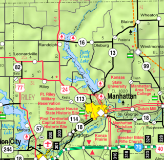
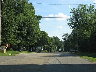
Zeandale is an unincorporated community in Riley County, Kansas, United States. As of the 2020 census, the population of the community and nearby areas was 62. It is located about 6.8 miles (10.9 km) east of Manhattan at the intersection of Tabor Valley Rd and K-18 highway.

Beecher Bible and Rifle Church is a historic church at the southeastern corner of Chapel and Elm Streets in Wabaunsee, Kansas. The church is named after Rev. Henry Ward Beecher, a financial backer for the town who helped smuggle rifles past pro-slavery forces in crates marked Beecher's Bibles.
Newbury is an unincorporated community in Wabaunsee County, Kansas, United States. As of the 2020 census, the population of the community and nearby areas was 78. It is located approximately 2 miles northwest of Paxico.


