Gray County, Kansas

Last updated

Gray County
Old Gray County Kansas courthouse from NE 1.JPG
Map of Kansas highlighting Gray County.svg
Location within the U.S. state of Kansas
Kansas in United States.svg
Kansas's location within the U.S.
Coordinates: 37°44′00″N100°25′59″W / 37.7333°N 100.433°W / 37.7333; -100.433
CountryFlag of the United States.svg United States
StateFlag of Kansas.svg  Kansas
FoundedMarch 13, 1881
Named for Alfred Gray
Seat Cimarron
Largest cityCimarron
Area
  Total869 sq mi (2,250 km2)
  Land869 sq mi (2,250 km2)
  Water0.4 sq mi (1 km2)  0.05%
Population
 (2020) [1]
  Total5,653
  Density6.5/sq mi (2.5/km2)
Time zone UTC−6 (Central)
  Summer (DST) UTC−5 (CDT)
Congressional district 1st
Website GrayCo.org

Gray County is a county located in the U.S. state of Kansas. Its county seat and most populous city is Cimarron. [2] As of the 2020 census, the county population was 5,653. [1] The county was named after Alfred Gray, a 19th century Kansas politician.

Contents

History

For millennia, the Great Plains of North America were inhabited by nomadic Native Americans.

In 1854, the Kansas Territory was organized, then in 1861 Kansas became the 34th U.S. state.

Gray County was founded in 1881 and named for Alfred Gray. [3] Between 1887 and 1893, a county seat war took place in Gray County that involved several notable Old West figures, such as Bat Masterson, Bill Tilghman, and Ben Daniels. As a result of the dispute, Cimarron became the permanent county seat of Gray County. [4]

Geography

According to the U.S. Census Bureau, the county has a total area of 869 square miles (2,250 km2), of which 869 square miles (2,250 km2) is land and 0.4 square miles (1.0 km2) (0.05%) is water. [5]

Since 2001, NextEra Energy Resources has operated the largest wind farm in Kansas—170 turbines with a generating capacity of 110 megawatts—on a 12,000-acre (49 km2) site near Montezuma. [6]

Adjacent counties

Demographics

Population pyramid based on 2000 census age data USA Gray County, Kansas age pyramid.svg
Population pyramid based on 2000 census age data
Historical population
CensusPop.Note
1890 2,415
1900 1,264−47.7%
1910 3,121146.9%
1920 4,71150.9%
1930 6,21131.8%
1940 4,773−23.2%
1950 4,8942.5%
1960 4,380−10.5%
1970 4,5163.1%
1980 5,13813.8%
1990 5,3965.0%
2000 5,9049.4%
2010 6,0061.7%
2020 5,653−5.9%
2023 (est.)5,743 [7] 1.6%
U.S. Decennial Census [8]
1790–1960 [9] 1900–1990 [10]
1990–2000 [11] 2010–2020 [1]

As of the 2000 census, [12] there were 5,904 people, 2,045 households, and 1,556 families residing in the county. The population density was 7 people per square mile (2.7 people/km2). There were 2,181 housing units at an average density of 2 per square mile (0.77/km2). The racial makeup of the county was 92.31% White, 0.46% Native American, 0.19% Black or African American, 0.10% Asian, 0.07% Pacific Islander, 5.42% from other races, and 1.46% from two or more races. Hispanic or Latino of any race were 9.81% of the population.

There were 2,045 households, out of which 42.00% had children under the age of 18 living with them, 67.70% were married couples living together, 5.60% had a female householder with no husband present, and 23.90% were non-families. 21.20% of all households were made up of individuals, and 9.40% had someone living alone who was 65 years of age or older. The average household size was 2.82 and the average family size was 3.31.

In the county, the population was spread out, with 31.60% under the age of 18, 8.30% from 18 to 24, 27.30% from 25 to 44, 20.20% from 45 to 64, and 12.70% who were 65 years of age or older. The median age was 33 years. For every 100 females there were 100.10 males. For every 100 females age 18 and over, there were 96.20 males.

The median income for a household in the county was $40,000, and the median income for a family was $45,299. Males had a median income of $31,519 versus $21,563 for females. The per capita income for the county was $18,632. About 6.50% of families and 9.10% of the population were below the poverty line, including 11.80% of those under age 18 and 8.00% of those age 65 or over.

Religion

Gray County has by far the highest percentage of adherents of the Church of God in Christ, Mennonite in the US. There were 1,032 members of the Church in Gray County in 2010, which is 17.18% of the population. It is the largest Church in the county. [13]

Government

Presidential elections

Gray county is often carried easily by Republican candidates. The last time a Democratic candidate carried this county was in 1976 by Jimmy Carter.

Presidential election results
United States presidential election results for Gray County, Kansas [14]
Year Republican Democratic Third party
No.%No.%No.%
2020 1,91183.52%34114.90%361.57%
2016 1,69882.19%26312.73%1055.08%
2012 1,60381.87%32416.55%311.58%
2008 1,64377.54%43620.58%401.89%
2004 1,81680.89%40818.17%210.94%
2000 1,63175.51%48222.31%472.18%
1996 1,45771.53%40419.83%1768.64%
1992 1,03947.81%44320.39%69131.80%
1988 1,18061.55%69636.31%412.14%
1984 1,58074.32%51424.18%321.51%
1980 1,31063.68%58328.34%1647.97%
1976 83742.08%1,11155.86%412.06%
1972 1,23569.15%51128.61%402.24%
1968 95255.25%61235.52%1599.23%
1964 64335.86%1,13663.36%140.78%
1960 1,15060.56%74439.18%50.26%
1956 1,27866.77%62732.76%90.47%
1952 1,51573.51%53726.06%90.44%
1948 1,03553.68%86945.07%241.24%
1944 1,05757.01%77541.80%221.19%
1940 1,05651.87%96247.25%180.88%
1936 76434.34%1,45965.57%20.09%
1932 91039.27%1,34858.18%592.55%
1928 1,29467.47%60631.60%180.94%
1924 95959.34%46328.65%19412.00%
1920 96262.18%50732.77%785.04%
1916 66038.66%88952.08%1589.26%
1912 11215.95%24334.62%34749.43%
1908 37246.79%33842.52%8510.69%
1904 28564.48%11325.57%449.95%
1900 18855.79%14543.03%41.19%
1896 15353.50%13346.50%00.00%
1892 27454.37%00.00%23045.63%
1888 41753.81%26834.58%9011.61%

Laws

Although the Kansas Constitution was amended in 1986 to allow the sale of alcoholic liquor by the individual drink with the approval of voters, Gray County has remained a prohibition, or "dry", county. [15]

Education

Unified school districts

Communities

2005 map of Gray County (map legend) Map of Gray Co, Ks, USA.png
2005 map of Gray County (map legend)

List of townships / incorporated cities / unincorporated communities / extinct former communities within Gray County. [16]

Cities and Towns

Unincorporated communities

Townships

Gray County is divided into seven townships. None of the cities within the county are considered governmentally independent, and all figures for the townships include those of the cities. In the following table, the population center is the largest city (or cities) included in that township's population total, if it is of a significant size.

Township FIPS Population
center
PopulationPopulation
density
/km2 (/sq mi)
Land area
km2 (sq mi)
Water area
km2 (sq mi)
Water %Geographic coordinates
Cimarron13300 Cimarron 2,3799 (24)254 (98)0 (0)0.03% 37°48′22″N100°20′52″W / 37.80611°N 100.34778°W / 37.80611; -100.34778
Copeland15500 Copeland 5402 (6)233 (90)0 (0)0.15% 37°33′57″N100°37′14″W / 37.56583°N 100.62056°W / 37.56583; -100.62056
East Hess195253721 (3)281 (108)0 (0)0.03% 37°37′45″N100°15′39″W / 37.62917°N 100.26083°W / 37.62917; -100.26083
Foote236751260 (1)310 (120)0 (0)0.02% 37°55′44″N100°20′46″W / 37.92889°N 100.34611°W / 37.92889; -100.34611
Ingalls342506462 (5)349 (135)0 (0)0.03% 37°47′43″N100°30′23″W / 37.79528°N 100.50639°W / 37.79528; -100.50639
Logan419002161 (2)309 (119)0 (0)0.04% 37°55′20″N100°33′52″W / 37.92222°N 100.56444°W / 37.92222; -100.56444
Montezuma47900 Montezuma 1,6253 (8)514 (198)0 (0)0.07% 37°35′56″N100°26′11″W / 37.59889°N 100.43639°W / 37.59889; -100.43639
Sources: "Census 2000 U.S. Gazetteer Files". U.S. Census Bureau, Geography Division. Archived from the original on August 2, 2002.

See also

Community information for Kansas

Related Research Articles

<span class="mw-page-title-main">Wilson County, Kansas</span> County in Kansas, United States

Wilson County is a county located in Southeast Kansas. Its county seat is Fredonia. As of the 2020 census, the county population was 8,624. The county was named after Hiero Wilson, a colonel in the American Civil War.

<span class="mw-page-title-main">Thomas County, Kansas</span> County in Kansas, United States

Thomas County is a county located in the U.S. state of Kansas. Its county seat is Colby. As of the 2020 census, the county population was 7,930. The county was named after George Thomas, a general during the American Civil War.

<span class="mw-page-title-main">Stevens County, Kansas</span> County in Kansas, United States

Stevens County is a county located in the U.S. state of Kansas. Its county seat is Hugoton. As of the 2020 census, the county population was 5,250. The county is named for Thaddeus Stevens, a Reconstruction era Pennsylvania politician.

<span class="mw-page-title-main">Seward County, Kansas</span> County in Kansas, United States

Seward County is a county of the U.S. state of Kansas. Its county seat and largest city is Liberal. As of the 2020 census, the county population was 21,964. The county was formed on March 20, 1873, and named after William Seward, a politician and Secretary of State under Abraham Lincoln and Andrew Johnson.

<span class="mw-page-title-main">Scott County, Kansas</span> County in Kansas, United States

Scott County is a county located in the U.S. state of Kansas. Its county seat is Scott City, the only incorporated city in the county. As of the 2020 census, the county population was 5,151. The county was named after Winfield Scott, a general in the United States Army from 1814 to 1861.

<span class="mw-page-title-main">Pottawatomie County, Kansas</span> County in Kansas, United States

Pottawatomie County is a county located in the U.S. state of Kansas. Its county seat is Westmoreland. As of the 2020 census, the county population was 25,348. The county was named for the Potawatomi tribe.

<span class="mw-page-title-main">Phillips County, Kansas</span> County in Kansas, United States

Phillips County is a county located in the U.S. state of Kansas. Its county seat and largest city is Phillipsburg. As of the 2020 census, the county population was 4,981. The county was named after William Phillips, a free-state abolition journalist and colonel in the American Civil War.

<span class="mw-page-title-main">Ness County, Kansas</span> County in Kansas, United States

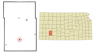
Ness County is a county located in the U.S. state of Kansas. Its county seat and largest city is Ness City. As of the 2020 census, the county population was 2,687. The county was named for Noah Ness, a corporal of the 7th Kansas Cavalry.

<span class="mw-page-title-main">Neosho County, Kansas</span> County in Kansas, United States

Neosho County is a county located in Southeast Kansas. Its county seat is Erie. As of the 2020 census, the county population was 15,904. The county was named for the Neosho River, which passes through the county.

<span class="mw-page-title-main">Nemaha County, Kansas</span> County in Kansas, United States

Nemaha County is a county located in the northeastern part of the U.S. state of Kansas. Its county seat is Seneca. As of the 2020 census, the county population was 10,273. The county was named for the Nemaha River.

<span class="mw-page-title-main">Morton County, Kansas</span> County in Kansas, United States

Morton County is a county in the southwestern corner of the U.S. state of Kansas. Its county seat and largest city is Elkhart. As of the 2020 census, the county population was 2,701. The county was named after Oliver Morton, the 14th governor of the state of Indiana.

<span class="mw-page-title-main">Linn County, Kansas</span> County in Kansas, United States

Linn County is a county in the U.S. state of Kansas, located in along the eastern edge of Kansas, and is part of the Kansas City metropolitan area. Its county seat is Mound City, and its most populous city is Pleasanton. As of the 2020 census, the county population was 9,591. The county was named for Lewis Linn, a U.S. Senator from Missouri.

<span class="mw-page-title-main">Lane County, Kansas</span> County in Kansas, United States

Lane County is a county located in the U.S. state of Kansas. Its county seat is Dighton, the only incorporated city in the county. As of the 2020 census, the county population was 1,574, making it the third-least populous county in Kansas. The county was named after James Lane, a leader of the Jayhawker abolitionist movement and served as one of the first U.S. senators from Kansas.

<span class="mw-page-title-main">Harvey County, Kansas</span> County in Kansas, United States

Harvey County is a county located in the U.S. state of Kansas. Its county seat and most populous city is Newton. As of the 2020 census, the county population was 34,024. The county was named for James Harvey, a U.S. senator and 5th governor of Kansas.

<span class="mw-page-title-main">Gove County, Kansas</span> County in Kansas, United States

Gove County is a county in the U.S. state of Kansas. Its county seat is Gove City, and its most populous city is Quinter. As of the 2020 census, the county population was 2,718. The county was named for Granville Gove, a captain of Company G of the 11th Kansas Cavalry Regiment Volunteer Cavalry, who died from battle wounds during the American Civil War.

<span class="mw-page-title-main">Coffey County, Kansas</span> County in Kansas, United States

Coffey County is a county located in Eastern Kansas. Its county seat and most populous city is Burlington. As of the 2020 census, the county population was 8,360. It was named after A.M. Coffey, a territorial legislator and Free-Stater during Bleeding Kansas era.

<span class="mw-page-title-main">Clark County, Kansas</span> County in Kansas, United States

Clark County is a county located in the U.S. state of Kansas. Its county seat and most populous city is Ashland. As of the 2020 census, the county population was 1,991. The county was named after Charles Clarke.

<span class="mw-page-title-main">Cherokee County, Kansas</span> County in Kansas, United States

Cherokee County is a U.S. county located in Southeast Kansas. Its county seat is Columbus, and its most populous city is Baxter Springs. As of the 2020 census, the county population was 19,362. The county was named for the Cherokee tribe.

<span class="mw-page-title-main">Cimarron, Kansas</span> City in Gray County, Kansas

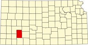
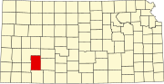
Cimarron is a city in and the county seat of Gray County, Kansas, United States. As of the 2020 census, the population of the city was 1,981. It is located along Highway 50.

<span class="mw-page-title-main">Montezuma, Kansas</span> City in Gray County, Kansas

Montezuma is a city in Gray County, Kansas, United States. As of the 2020 census, the population of the city was 975.

References

  1. 1 2 3 "QuickFacts; Gray County, Kansas; Population, Census, 2020 & 2010". United States Census Bureau. Archived from the original on August 16, 2021. Retrieved August 16, 2021.
  2. "Find a County". National Association of Counties. Archived from the original on May 31, 2011. Retrieved June 7, 2011.
  3. Gannett, Henry (1905). The Origin of Certain Place Names in the United States. Govt. Print. Off. pp.  142.
  4. "Feudin' and Fightin' Friday: County Seat Wars – Diggin' History". Archived from the original on April 7, 2014. Retrieved April 6, 2014.
  5. "US Gazetteer files: 2010, 2000, and 1990". United States Census Bureau. February 12, 2011. Retrieved April 23, 2011.
  6. "Gray County Wind Farm". Aquila, Inc. Archived from the original on June 13, 2007. Retrieved June 2, 2007.
  7. "Annual Estimates of the Resident Population for Counties: April 1, 2020 to July 1, 2023". United States Census Bureau. Retrieved April 3, 2024.
  8. "U.S. Decennial Census". United States Census Bureau. Retrieved July 24, 2014.
  9. "Historical Census Browser". University of Virginia Library. Retrieved July 24, 2014.
  10. "Population of Counties by Decennial Census: 1900 to 1990". United States Census Bureau. Retrieved July 24, 2014.
  11. "Census 2000 PHC-T-4. Ranking Tables for Counties: 1990 and 2000" (PDF). United States Census Bureau. Archived (PDF) from the original on March 27, 2010. Retrieved July 24, 2014.
  12. "U.S. Census website". United States Census Bureau . Retrieved January 31, 2008.
  13. Association of Religious Data Archives: Church of God in Christ, Mennonite Counties (2010) Retrieved May 2, 2015
  14. "Dave Leip's Atlas of U.S. Presidential Elections".
  15. "Map of Wet and Dry Counties". Alcoholic Beverage Control, Kansas Department of Revenue. November 2004. Archived from the original on October 8, 2007. Retrieved January 21, 2007.
  16. 1 2 "General Highway Map of Gray County, Kansas" (PDF). Kansas Department of Transportation (KDOT). December 2008. Archived (PDF) from the original on October 3, 2023.

Further reading

County
Other
Maps

37°44′N100°26′W / 37.733°N 100.433°W / 37.733; -100.433