Miami County, Kansas

Last updated

Miami County
Miami county kansas courthouse 2009.jpg
Miami County Courthouse in Paola (2009)
Map of Kansas highlighting Miami County.svg
Location within the U.S. state of Kansas
Kansas in United States.svg
Kansas's location within the U.S.
Coordinates: 38°35′00″N94°51′00″W / 38.5833°N 94.85°W / 38.5833; -94.85
CountryFlag of the United States.svg United States
StateFlag of Kansas.svg  Kansas
FoundedAugust 25, 1855
Named for Miami tribe
Seat Paola
Largest city Spring Hill
Area
  Total590 sq mi (1,500 km2)
  Land576 sq mi (1,490 km2)
  Water15 sq mi (40 km2)  2.5%
Population
 (2020) [1]
  Total34,191
  Estimate 
(2021) [2]
34,593
  Density59.4/sq mi (22.9/km2)
Time zone UTC−6 (Central)
  Summer (DST) UTC−5 (CDT)
Congressional district 3rd
Website MiamiCountyKS.org

Miami County is a county located in east-central Kansas and is part of the Kansas City metropolitan area. [3] Its county seat and most populous city is Paola. [4] As of the 2020 census, the county population was 34,191. [1] The county was named for the Miami tribe.

Contents

History

Native Americans

The first settlements of the area were by Native American Indian tribes, primarily in the 1820s through the 1840s. This was due to their removal from areas east (Ohio, Illinois and Indiana)and the designation of the area as part of the Indian Territory. The tribes included were the Miami and Shawnee, and the Pottawatomie, Piankeshaw, Kaskaskia, Wea and Peoria, which comprised the Confederated Tribes. The original Miami reservation consisted of approximately 500,000 acres (2,000 km2). Early white settlers during that time were primarily serving as missionaries to the tribes. Over time, other settlers continued to arrive to build homes on the Miami reservation, and by 1854, the U.S. Government purchased all but 72,000 acres (290 km2) from the Miami tribe. [5]

Two notable members of the Confederated Tribes were Christmas Dagnette, and Baptiste Peoria. Dagnette was born in 1800, and was a nephew of a Wea chief, originally from Indiana. He had received some formal education, spoke several of the Native American languages, and additionally spoke English, French and Spanish. He had served as an interpreter to the U.S. Government by the age of sixteen. Having moved to the area that is now Miami County with the Wea tribe, he served as chief for several years before his death in 1848. Baptiste Peoria was also born around 1800, and while he didn't receive formal education like Dagnette, he learned the languages of the Shawnee, Delaware, Pottawatomie, and several more of the Confederated Tribes. In addition, he spoke English and French. [6] Peoria was of both French and Native American Indian ethnicity, and like Dagnette, served as an interpreter and as a chief for some time. Baptiste Peoria became a respected member of the Paola Town Company, and was instrumental in the founding and development of the city of Paola in the early and mid-1860s. He moved (to what is now Oklahoma) with his tribe in 1868, when they were once again removed to a newly designated Indian territory, and died there in 1878. Some of the Native American Indians stayed in the area (Miami County), and became citizens of the United States. [7]

Trail of Death

A notorious path known as the Trail of Death has been officially recognized by the states of Indiana, Illinois, Missouri and Kansas. Signs in all four states highlight the regional historic pathway. The 27-mile trail through the county follows local roads starting in the north at the intersection of 215th Street and Metcalf Avenue(old U.S. Highway 69). It moves south along Metcalf Avenue to Kansas Highway 68, where it again turns west along K-68 to Old Kansas City Road north of Paola. There it turns south on Old KC Road to Baptiste Drive in Paola. The trail makes a short turn back east on Baptiste Drive to North Pearl Street, where it turns south again to West Wea Street adjacent to Paola's historic Square. It turns west on Wea Street to South Silver Street, follows what is also known as Old Kansas City Road to 327th Street. By turning west on 327th, the trail enters its final path on one road that undergoes several names. The county road 327th Street becomes 6th St Osawatomie as it turns south and enters the city limits. As it exits the city limits, it becomes Plum Creek Road/ K-7 Highway. The farthest south monument for the Trail of Death is located at 363rd Street and Plum Creek Road.

A treaty signed in 1836 forced Indian tribes in the Eastern United States to move west of the Mississippi River, but Pottawatomie Chief Menominee, his tribe, and others refused to leave their land. In autumn 1838, the Pottawatomie were removed by force from their villages and underwent a treacherous two-month journey. On the trip, 42 of the 859 Native Americans died, most of them children and the elderly, from typhoid fever and the stress of the passage. They were buried along the route, which became known as the Trail of Death.

When they reached Kansas, some Pottawatomie lived for about a decade in Linn County at Sugar Creek Trading Post, which is now St. Philippine Duchesne Memorial Park. Other Pottawatomie tribes were relocated to various eastern parts of the state.

The trail, which marks the route the Pottawatomie took, begins in Rochester, Ind., and meanders through Illinois and Missouri to end in eastern Kansas. The route was documented by Jesse C. Douglas, who accompanied the group on the march.

The Trail of Death Commemorative Caravan of Pottawatomie Indians and historians has retraced the 660-mile trail every five years since 1988. Travelers on the trail today can view artifacts from the Pottawatomie Tribe along with other historical displays at the Miami County Historical Museum located in Paola, 12 E. Peoria St. Those displays include a diary of their trip, which hangs just outside the Early American History Room. [8]

Pre-Civil War Period

When Kansas Territory was incorporated in 1854 due to the Kansas–Nebraska Act, the Missouri Compromise of 1820 was essentially repealed. Bordering the slave state of Missouri to its east, the county (Miami) and surrounding areas became a location for violence between abolitionists and the "border ruffians" of Missouri. These acts of violence and battles that took place primarily from 1854 to 1858, became known as border wars, and Kansas became known as Bleeding Kansas. Kansas Territory was not yet a state, and it was a battle on which forces would become dominant, slave or free. Many abolitionists came from other states to live in the area and ensure Kansas' entry as a state as a free, or anti-slavery one. The county's most notable abolitionist was John Brown, who moved to Osawatomie, making it the headquarters for him and his anti-slavery forces. As a result of this, Osawatomie, as well as the surrounding countryside and communities became the center for several battles and acts of violence during this period. Near Osawatomie are historic sites of John Brown, such as his famous Civil War lookout. [6]

Etymology

The county was originally established in 1855 as Lykins County, after Dr. David Lykins. Lykins was a Baptist missionary to the Native American Indian tribes in the area, and had built a school for them in what is now rural Miami County. He also served as a member of the territorial council, and was pro-slavery. By January 1861, the anti-slavery forces had been established as dominant, and Kansas entered the union as a free state. As a result of Dr. Lykins' views on slavery, Lykins County's name was changed to Miami County on June 3, 1861. The new name was in honor of the predominant Native American tribe that settled the area, the Miami. [9]

Natural gas

In 1882, a large deposit of natural gas was discovered in rural Miami County, 7 miles (11 km) east of Paola. By 1886 a pipeline was completed to the town's square, where it illuminated lamps there. By 1887, Paola had its street lamps lighted with lamps using natural gas. Other fields of natural gas were discovered throughout Miami County by 1887, and for a time, the area around Paola was considered to be a gas belt. In the summer of 1887, a Natural Gas Jubilee was held, which was a celebration for people to come and marvel at the use of natural gas. [6]

Geography

According to the U.S. Census Bureau, the county has a total area of 590 square miles (1,500 km2), of which 576 square miles (1,490 km2) is land and 15 square miles (39 km2) (2.5%) is water. [10]

Lakes

Other lakes in Miami County, each with specific restrictions and activities to offer, include:

Adjacent counties

Demographics

Population pyramid based on 2000 census age data USA Miami County, Kansas age pyramid.svg
Population pyramid based on 2000 census age data
Historical population
CensusPop.Note
1860 4,980
1870 11,725135.4%
1880 17,80251.8%
1890 19,61410.2%
1900 21,64110.3%
1910 20,030−7.4%
1920 19,809−1.1%
1930 21,2437.2%
1940 19,489−8.3%
1950 19,6981.1%
1960 19,8840.9%
1970 19,254−3.2%
1980 21,61812.3%
1990 23,4668.5%
2000 28,35120.8%
2010 32,78715.6%
2020 34,1914.3%
2023 (est.)35,320 [12] 3.3%
U.S. Decennial Census [13]
1790-1960 [14] 1900-1990 [15]
1990-2000 [16] 2010-2020 [1]

Miami County is included in the Kansas City, MO-KS Metropolitan Statistical Area.

As of the 2000 census, [17] there were 28,351 people, 10,365 households, and 7,794 families residing in the county. The population density was 49 people per square mile (19 people/km2). There were 10,984 housing units at an average density of 19 per square mile (7.3/km2). The racial makeup of the county was 95.96% White, 1.54% Black or African American, 0.52% Native American, 0.17% Asian, 0.01% Pacific Islander, 0.44% from other races, and 1.36% from two or more races. Hispanic or Latino of any race were 1.59% of the population.

There were 10,365 households, out of which 37.00% had children under the age of 18 living with them, 63.50% were married couples living together, 8.00% had a female householder with no husband present, and 24.80% were non-families. 21.00% of all households were made up of individuals, and 8.80% had someone living alone who was 65 years of age or older. The average household size was 2.66 and the average family size was 3.09.

In the county, the population was spread out, with 27.90% under the age of 18, 7.30% from 18 to 24, 29.70% from 25 to 44, 23.10% from 45 to 64, and 11.90% who were 65 years of age or older. The median age was 37 years. For every 100 females there were 97.80 males. For every 100 females age 18 and over, there were 96.00 males.

The median income for a household in the county was $46,665, and the median income for a family was $55,830. Males had a median income of $37,441 versus $27,271 for females. The per capita income for the county was $21,408. About 3.60% of families and 5.50% of the population were below the poverty line, including 5.40% of those under age 18 and 8.40% of those age 65 or over.

Landmarks

Miami County communities are host to many landmarks and buildings with historical significance. From historical bridges and architecture such as the Creamery Bridge, as well as John Brown & Civil War history in and near Osawatomie, to the hall of fame musical landmark and cider mill near Louisburg, to a library constructed in honor of a wine maker in Paola. The Poor Farm Cemetery, historically significant because many of those interred at the site once worked the county's Poor Farm, is just one of several historical cemeteries. [7]

Community

The location of Miami County, a short drive south of Kansas City, allows it to offer residents and visitors aspects of both city and rural lifestyles. Miami County and its cities, Paola, Louisburg, Spring Hill, Osawatomie, and Fontana offer a variety of activities and hobbies. Among them are golf, hiking, camping, fishing, hunting, horseback riding, water sports, astronomy and a variety of community festivals and events that take place throughout the year. There are also historical places and museums to study its history. During the summer, each community offers a farmer's market with booths offering locally grown food and goods. [7]

Miami County Farm Tour

In the spring of each year, various Miami County farms and farm businesses participate in the Miami County Farm Tour. The public is invited to come to each farm with their families as part of a free self-guided driving tour. The goal is to experience and learn about the operations, produce and/or animals at each farm stop. Visitors and residents of Miami County have made the farm tour an annual event. [7]

Agriculture

According to the USDA's 2007 Census of Agriculture, Miami County has 1,538 farms and the average size of the farm is 200 acres (81 ha). Forage, including hay, grass silage, etc... tops the crop list with over 54,000 acres (22,000 ha). More than 40,000 acres (16,000 ha) within the county are used to grow soybeans. Corn is planted to over 20,500 acres (8,300 ha). The top livestock items in number are Cattle and calves, totaling over 43,000. Horses and layers (chickens) are next with over 3,400 and 2,100 respectively. ( [18]

The 1990 World Supreme Champion dairy cow once resided in Miami County. This holstein cow, named Enns Banner Olivia, came to Miami County from Marion County, Kansas when she was three years old to the farm named Keene, Pretz Holsteins. [19]

Miami County has the Fontana Co-Op for farmers to take harvested crop for storage until ready for market. There are two locations for them to make use of. [7]

Government

Presidential elections

Presidential election results
United States presidential election results for Miami County, Kansas [20]
Year Republican Democratic Third party
No.%No.%No.%
2020 12,30868.42%5,24729.17%4342.41%
2016 10,00365.92%3,99126.30%1,1817.78%
2012 9,85866.36%4,71231.72%2861.93%
2008 9,38261.01%5,74237.34%2531.65%
2004 9,01364.31%4,83834.52%1651.18%
2000 6,61156.96%4,55439.23%4423.81%
1996 5,25647.98%4,23738.68%1,46213.35%
1992 3,52831.80%3,83534.56%3,73333.64%
1988 4,80751.65%4,42747.57%720.77%
1984 5,87765.04%3,07634.04%830.92%
1980 4,74057.10%3,07137.00%4905.90%
1976 3,99948.67%4,00048.69%2172.64%
1972 5,23469.04%2,14028.23%2072.73%
1968 3,61448.93%2,73937.08%1,03313.99%
1964 2,90738.40%4,62061.03%430.57%
1960 4,85757.85%3,50541.75%340.40%
1956 5,03159.30%3,42840.41%250.29%
1952 5,62362.33%3,37437.40%250.28%
1948 3,65049.40%3,66049.54%781.06%
1944 4,32657.28%3,21742.60%90.12%
1940 5,17856.77%3,90042.76%430.47%
1936 4,67650.33%4,60149.52%140.15%
1932 3,66743.04%4,73955.62%1141.34%
1928 5,93172.71%2,14826.33%780.96%
1924 4,78861.76%1,99425.72%97112.52%
1920 4,06060.92%2,45036.76%1542.31%
1916 3,08641.74%4,04754.74%2603.52%
1912 1,03323.71%1,91944.05%1,40432.23%
1908 2,47551.03%2,25646.52%1192.45%
1904 2,89963.46%1,42531.20%2445.34%
1900 2,66352.27%2,40147.12%310.61%
1896 2,54147.10%2,81252.12%420.78%
1892 2,24349.10%00.00%2,32550.90%
1888 2,17051.31%1,60037.83%45910.85%

Laws

Miami County was a prohibition, or "dry", county until the Kansas Constitution was amended in 1986 and voters approved the sale of alcoholic liquor by the individual drink with a 30 percent food sales requirement. [21]

The county voted "No" on the 2022 Kansas Value Them Both Amendment, an anti-abortion ballot measure, by 52% to 48% despite backing Donald Trump with 68% of the vote to Joe Biden's 29% in the 2020 presidential election. [22]

Education

At one time in its history, Miami County had more than 100 schools. While most of those school buildings either no longer exist, or have been vacant for many years, the Rock Creek School at 231st & Pressonville, a one-room schoolhouse built in 1910, was used as a school until 1966. The residents near it in the northwest corner of Miami County, purchased the red brick schoolhouse from the school district for $1. Today, the schoolhouse is still used as a township hall to hold meetings, suppers, and other community events. [23] In 1878, a Normal School, one of five in the state of Kansas, was established in Paola by Professor John Wherrell, which flourished for six years. Notable students of the Normal School were: U.S. Senator Chester I. Long, and the father of peanuts George Washington Carver. [24]

Unified school districts

Communities

2005 map of Miami County (map legend) Map of Miami Co, Ks, USA.png
2005 map of Miami County (map legend)

List of townships / incorporated cities / unincorporated communities / extinct former communities within Miami County. [25]

Cities

‡ means a community has portions in an adjacent county.

Unincorporated communities

† means a community is designated a Census-Designated Place (CDP) by the United States Census Bureau.

Townships

Miami County is divided into thirteen townships. The cities of Louisburg, Osawatomie, Paola, and Spring Hill are considered governmentally independent and are excluded from the census figures for the townships. In the following table, the population center is the largest city (or cities) included in that township's population total, if it is of a significant size.

Township FIPS Population
center
PopulationPopulation
density
/km2 (/sq mi)
Land area
km2 (sq mi)
Water area
km2 (sq mi)
Water %Geographic coordinates
Marysville451002,57520 (51)131 (50)12 (5)8.28% 38°40′48″N94°51′31″W / 38.68000°N 94.85861°W / 38.68000; -94.85861
Miami461005064 (10)126 (48)1 (0)0.53% 38°27′56″N94°44′47″W / 38.46556°N 94.74639°W / 38.46556; -94.74639
Middle Creek462251,64911 (28)151 (58)1 (1)0.89% 38°34′8″N94°42′32″W / 38.56889°N 94.70889°W / 38.56889; -94.70889
Mound487007058 (22)83 (32)0 (0)0.06% 38°25′32″N94°58′56″W / 38.42556°N 94.98222°W / 38.42556; -94.98222
Osage531756496 (16)106 (41)0 (0)0.46% 38°26′0″N94°50′58″W / 38.43333°N 94.84944°W / 38.43333; -94.84944
Osawatomie532507949 (23)90 (35)0 (0)0.12% 38°29′7″N94°58′53″W / 38.48528°N 94.98139°W / 38.48528; -94.98139
Paola542751,10016 (40)71 (27)0 (0)0.65% 38°33′48″N94°51′44″W / 38.56333°N 94.86222°W / 38.56333; -94.86222
Richland594751,75811 (27)166 (64)16 (6)8.89% 38°40′23″N95°0′11″W / 38.67306°N 95.00306°W / 38.67306; -95.00306
Stanton679259259 (23)103 (40)0 (0)0.37% 38°32′51″N95°0′32″W / 38.54750°N 95.00889°W / 38.54750; -95.00889
Sugar Creek688254494 (11)104 (40)1 (0)0.63% 38°26′40″N94°40′14″W / 38.44444°N 94.67056°W / 38.44444; -94.67056
Ten Mile701251,25910 (27)121 (47)1 (0)0.51% 38°40′12″N94°45′41″W / 38.67000°N 94.76139°W / 38.67000; -94.76139
Valley729501,47816 (41)93 (36)0 (0)0.37% 38°30′54″N94°52′25″W / 38.51500°N 94.87361°W / 38.51500; -94.87361
Wea762251,83616 (41)117 (45)1 (0)0.43% 38°39′39″N94°40′49″W / 38.66083°N 94.68028°W / 38.66083; -94.68028
Sources: "Census 2000 U.S. Gazetteer Files". U.S. Census Bureau, Geography Division. Archived from the original on August 2, 2002.

See also

Community information for Kansas

Related Research Articles

<span class="mw-page-title-main">Montgomery County, Kansas</span> County in Kansas, United States

Montgomery County is a county located in Southeast Kansas. Its county seat is Independence, and its most populous city is Coffeyville. As of the 2020 census, the county population was 31,486. The county was named after Richard Montgomery, a major general during the American Revolutionary War.

<span class="mw-page-title-main">Ottawa County, Oklahoma</span> County in Oklahoma, United States

Ottawa County is a county located in the northeastern corner of the U.S. state of Oklahoma. As of the 2020 census, the population was 30,285. Its county seat is Miami. The county was named for the Ottawa Tribe of Oklahoma. It is also the location of the federally recognized Modoc Nation and the Quapaw Nation, which is based in Quapaw.

<span class="mw-page-title-main">Jackson County, Missouri</span> County in Missouri, United States

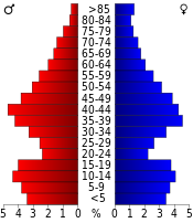
Jackson County is located in the western portion of the U.S. state of Missouri, on the border with Kansas. As of the 2020 census, the population was 717,204. making it the second-most populous county in the state.

<span class="mw-page-title-main">Stevens County, Kansas</span> County in Kansas, United States

Stevens County is a county located in the U.S. state of Kansas. Its county seat is Hugoton. As of the 2020 census, the county population was 5,250. The county is named for Thaddeus Stevens, a Reconstruction era Pennsylvania politician.

<span class="mw-page-title-main">Shawnee County, Kansas</span> County in Kansas, United States

Shawnee County is located in northeast Kansas, in the central United States. Its county seat and most populous city is Topeka, the state capital. As of the 2020 census, the population was 178,909, making it the third-most populous county in Kansas. The county was one of the original 33 counties created by the first territorial legislature in 1855, and it was named for the Shawnee tribe.

<span class="mw-page-title-main">Pottawatomie County, Kansas</span> County in Kansas, United States

Pottawatomie County is a county located in the U.S. state of Kansas. Its county seat is Westmoreland. As of the 2020 census, the county population was 25,348. The county was named for the Potawatomi tribe.

<span class="mw-page-title-main">Johnson County, Kansas</span> County in Kansas, United States

Johnson County is a county in the U.S. state of Kansas, along the border of the state of Missouri. Its county seat is Olathe. As of the 2020 census, the population was 609,863, the most populous county in Kansas. The county was named after Thomas Johnson, a Methodist missionary who was one of the state's first settlers. Largely suburban, the county contains a number of suburbs of Kansas City, Missouri, including Overland Park, a principal city of and second most populous city in the Kansas City Metropolitan Area.

<span class="mw-page-title-main">Franklin County, Kansas</span> County in Kansas, United States

Franklin County is a county located in the eastern portion of the U.S. state of Kansas. Its county seat and most populous city is Ottawa. As of the 2020 census, the county population was 25,996. The county was named for Benjamin Franklin, a founding father of the United States. Formerly it was considered part of the Kansas City metropolitan area, but was removed in 2013.

<span class="mw-page-title-main">Comanche County, Kansas</span> County in Kansas, United States

Comanche County is a county located in the U.S. state of Kansas. Its county seat and most populous city is Coldwater. As of the 2020 census, the county population was 1,689. The county was named after the Comanche tribe.

<span class="mw-page-title-main">Greeley, Kansas</span> City in Anderson County, Kansas

Greeley is a city in Anderson County, Kansas, United States. As of the 2020 census, the population of the city was 273.

<span class="mw-page-title-main">Louisburg, Kansas</span> City in Kansas, United States

Louisburg is a city in Miami County, Kansas, United States. As of the 2020 census, the population of the city was 4,969.

<span class="mw-page-title-main">Osawatomie, Kansas</span> City in Kansas, United States

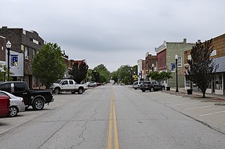
Osawatomie is a city in Miami County, Kansas, United States, 61 miles (98 km) southwest of Kansas City. As of the 2020 census, the population of the city was 4,255. It derives its name as a portmanteau of two nearby streams, the Marais des Cygnes River and Pottawatomie Creek.

<span class="mw-page-title-main">Paola, Kansas</span> City and County seat in Kansas, United States

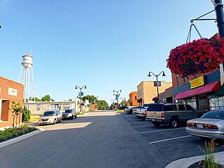
Paola is a city in and the county seat of Miami County, Kansas, United States. As of the 2020 census, the population of the city was 5,768.

<span class="mw-page-title-main">Miami, Oklahoma</span> City in Oklahoma, United States

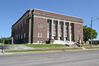
Miami is a city in and the county seat of Ottawa County, Oklahoma, United States, founded in 1891. Lead and zinc mining were established by 1918, causing the area's economy to boom.

<span class="mw-page-title-main">Peoria, Oklahoma</span> Town in Oklahoma, United States

Peoria is a town in Ottawa County, Oklahoma, United States. It was named for the Peoria people, a tribe of Native Americans who were removed to Indian Territory from east of the Mississippi River during the 19th century. The territory had been occupied by the Quapaw people, who sold some of their land to the Peoria. The population was 131 at the 2010 U. S. Census, down from 141 at the 2000 census. The long decline of mining meant that jobs moved elsewhere.

<span class="mw-page-title-main">Peoria people</span> Native American ethnicity

The Peoria are a Native American people. They are enrolled in the federally recognized Peoria Tribe of Indians of Oklahoma headquartered in Miami, Oklahoma.

<span class="mw-page-title-main">Wea</span> Native American tribe originally located in western Indiana

The Wea were a Miami–Illinois-speaking Native American tribe originally located in western Indiana. Historically, they were described as either being closely related to the Miami tribe or a sub-tribe of Miami.

East-Central Kansas is a region of Kansas. It is located between the Kansas City metropolitan area and Southeast Kansas, and on the border with Missouri. The region extends westward towards the Flint Hills to Lyon County. East-Central Kansas geographically features rolling hills and deep forested river valleys. The main crop of this predominantly agricultural region is corn. The area is more forested and more moist compared to the rest of the state. East-Central Kansas is rich with state history, as many locations of this region saw battles in Bleeding Kansas, and the infamous abolitionist John Brown and his men battled in Osawatomie. Much of the area is powered by Wolf Creek Nuclear Generating Station which is located near Burlington. The most populous cities of the region include Emporia, Ottawa, Paola, Osawatomie, Garnett, Osage City, Burlington, and Louisburg.

<span class="mw-page-title-main">Johnston Lykins</span> 2nd mayor of Kansas City, Missouri (1854-1855)

Johnston Lykins was a prominent settler and civic leader in the American frontier Town of Kansas, which became Kansas City, Missouri. He was editor of the first printing press in what became Kansas, and founded the area's first bank, newspaper, and Baptist church. He was the Town of Kansas's first president of city council, and first duly elected mayor. He is reportedly "possibly associated with more Kansas City 'firsts' than any other early settler".

<span class="mw-page-title-main">Wea, Kansas</span> Unincorporated community in Kansas, United States

Wea is an unincorporated community in Miami County, Kansas, United States. It is part of the Kansas City metropolitan area.

References

  1. 1 2 3 "QuickFacts; Miami County, Kansas; Population, Census, 2020 & 2010". United States Census Bureau. Archived from the original on August 18, 2021. Retrieved August 17, 2021.
  2. "County Population Totals: 2020-2021". United States Census Bureau. March 24, 2022. Retrieved June 3, 2022.
  3. "Population Data and Maps | MARC". Archived from the original on September 16, 2014. Retrieved October 14, 2019.
  4. "Find a County". National Association of Counties. Retrieved June 7, 2011.
  5. Andreas, A. T. (1883). History of the State of Kansas, containing a full account of its growth from an uninhabited territory to a wealthy and important State. Chicago, Illinois: A. T. Andreas. pp. pt. 1, p. 876.
  6. 1 2 3 "Miami County History". Swan River Museum. Archived from the original on July 16, 2009. Retrieved December 21, 2009.
  7. 1 2 3 4 5 6 "Miami County 2009 Visitors Guide"
  8. "Historic". MICO Econ Dev. Retrieved March 7, 2013.[ permanent dead link ]
  9. "Kansas Counties". Kansas State Historical Society. Archived from the original on September 19, 2008. Retrieved December 21, 2009.
  10. "US Gazetteer files: 2010, 2000, and 1990". United States Census Bureau. February 12, 2011. Retrieved April 23, 2011.
  11. "Miami County Lakes". Fishing Works. Retrieved December 22, 2009.
  12. "Annual Estimates of the Resident Population for Counties: April 1, 2020 to July 1, 2023". United States Census Bureau. Retrieved April 3, 2024.
  13. "U.S. Decennial Census". United States Census Bureau. Retrieved July 27, 2014.
  14. "Historical Census Browser". University of Virginia Library. Retrieved July 27, 2014.
  15. "Population of Counties by Decennial Census: 1900 to 1990". United States Census Bureau. Retrieved July 27, 2014.
  16. "Census 2000 PHC-T-4. Ranking Tables for Counties: 1990 and 2000" (PDF). United States Census Bureau. Archived (PDF) from the original on March 27, 2010. Retrieved July 27, 2014.
  17. "U.S. Census website". United States Census Bureau . Retrieved January 31, 2008.
  18. "Census of Agriculture". USDA. Archived from the original on September 1, 2012. Retrieved May 15, 2012.
  19. "World Dairy Supreme Champions". Dairy Cow Daily. Retrieved March 7, 2013.
  20. "Dave Leip's Atlas of U.S. Presidential Elections".
  21. "Map of Wet and Dry Counties". Alcoholic Beverage Control, Kansas Department of Revenue. November 2006. Archived from the original on October 8, 2007. Retrieved December 28, 2007.
  22. Panetta, Grace (August 3, 2022). "14 of the 19 Kansas counties that rejected an anti-abortion amendment voted for Trump in 2020". Business Insider. Retrieved August 3, 2022.
  23. "Residents Celebrate 100th Anniversary of Rock Creek School". LJWorld.com. Retrieved May 15, 2012.
  24. "Paola 150 Years". Miami County Historical Museum. Retrieved May 15, 2012.
  25. 1 2 "General Highway Map of Miami County, Kansas" (PDF). Kansas Department of Transportation (KDOT). March 2008. Archived (PDF) from the original on May 31, 2024.
Notes

    Further reading

    County
    Maps

    38°35′N94°51′W / 38.583°N 94.850°W / 38.583; -94.850