Finney County, Kansas

Last updated

Finney County
Finney County, Kansas courthouse from NE 1.JPG
Finney County Courthouse in Garden City (2015)
Map of Kansas highlighting Finney County.svg
Location within the U.S. state of Kansas
Kansas in United States.svg
Kansas's location within the U.S.
Coordinates: 37°57′38″N100°51′21″W / 37.9606°N 100.8558°W / 37.9606; -100.8558
CountryFlag of the United States.svg United States
StateFlag of Kansas.svg  Kansas
FoundedFebruary 22, 1883
Named for David W. Finney
Seat Garden City
Largest cityGarden City
Area
  Total1,303 sq mi (3,370 km2)
  Land1,302 sq mi (3,370 km2)
  Water0.7 sq mi (2 km2)  0.05%
Population
 (2020) [1]
  Total38,470
  Density29.5/sq mi (11.4/km2)
Time zone UTC−6 (Central)
  Summer (DST) UTC−5 (CDT)
Congressional district 1st
Website FinneyCounty.org

Finney County is a county located in the U.S. state of Kansas. Its county seat and most populous city is Garden City. [2] As of the 2020 census, the county population was 38,470. The county was named for David Finney, the Lieutenant Governor of Kansas from 1881 and 1885. In 2020, 51.4 percent of the population in the county was Hispanic, one of a few counties in Kansas with a Hispanic majority population. [1]

Contents

History

Finney County was established in 1867 and named after Lt. Gov. John W. Finney. [3] The first white settlers arrived in 1878, settling along the Arkansas River and its tributaries. [3]

Finney County began about 1880 as Buffalo County and Sequoyah County[ citation needed ], named after Sequoyah, the Cherokee Indian responsible for the development of the Cherokee alphabet. The two counties were merged and renamed Finney County in honor of then Lieutenant Governor David Wesley Finney. [4] The county grew to the current shape after Garfield County was annexed to it in 1893. The northeast block, separate from the otherwise rectangular area, represents what at one time was Garfield County, which is now occupied partially by the Garfield Township. [5]

The town of Garden City was founded in 1879 by the cattle firm of Jones and Plummer, who established it as a shipping point for Texas cattle being driven along the Jones & Plummer Trail to Dodge City. [3] Garden City grew rapidly as a railroad hub when the Atchison, Topeka & Santa Fe and Chicago, Rock Island & Pacific railroads arrived in 1888. [3]

As described in Blackmar's Cyclopedia, Garden City "was a typical frontier town, with its gambling houses, dance halls and other adjuncts of border civilization" in its early years, but it quickly transformed into an agricultural center for southwest Kansas. [3]

Other early settlements like Holcomb, Kalvesta, and Pierceville sprung up in the 1880s as Finney County became a prosperous region for wheat farming and cattle ranching. [3] The county population boomed from just 537 in 1880 to over 5,000 by 1890 as homesteaders poured in. [3]

In 1893, the former Garfield County was annexed into Finney County and organized as Garfield Township. Garfield County had originally been established in 1887 from parts of Finney County and other surrounding counties, but it struggled to maintain a viable tax base and population. [6]

By 1910, Finney County had a population exceeding 10,000 as agriculture firmly took root in the region after its pioneering days on the frontier. [3]

Between 2007 and 2008 Finney County became majority-minority. [7]

Geography

According to the U.S. Census Bureau, the county has a total area of 1,303 square miles (3,370 km2), of which 1,302 square miles (3,370 km2) is land and 0.7 square miles (1.8 km2) (0.05%) is water. [8] It is the second-largest county in Kansas by area.

Adjacent counties

Demographics

Population pyramid based on 2000 census age data USA Finney County, Kansas age pyramid.svg
Population pyramid based on 2000 census age data
Historical population
CensusPop.Note
1890 4,231
1900 3,469−18.0%
1910 6,90899.1%
1920 7,67411.1%
1930 11,01443.5%
1940 10,092−8.4%
1950 15,09249.5%
1960 16,0936.6%
1970 18,94717.7%
1980 23,82525.7%
1990 33,07038.8%
2000 40,52322.5%
2010 36,776−9.2%
2020 38,4704.6%
2023 (est.)37,466 [9] −2.6%
U.S. Decennial Census [10]
1790-1960 [11] 1900-1990 [12]
1990-2000 [13] 2010-2020 [1]

Finney County is included in the Garden City, KS Micropolitan Statistical Area.

2010 census

As of the 2010 census [14] there were 36,776 people, 12,359 households and 8,903 families living in the county. The racial makeup of the county was 77.0% White, 2.3% Black or African American, 0.9% Native American, 3.4% Asian, 0.0% Pacific Islander, 13.6% from other races, and 2.9% from two or more races. Hispanic or Latino of any race were 46.7% of the population.

2000 census

As of the 2000 census, [14] there were 40,523 people, 12,948 households, and 9,749 families living in the county. The population density was 31 people per square mile (12 people/km2). There were 13,763 housing units at an average density of 11 per square mile (4.2/km2). The racial makeup of the county was 69.05% White, 1.25% Black or African American, 0.96% Native American, 2.87% Asian, 0.08% Pacific Islander, 22.99% from other races, and 2.80% from two or more races. Hispanic or Latino of any race were 43.30% of the population.

There were 12,948 households, out of which 46.00% had children under the age of 18 living with them, 59.80% were married couples living together, 10.50% had a female householder with no husband present, and 24.70% were non-families. 19.60% of all households were made up of individuals, and 6.30% had someone living alone who was 65 years of age or older. The average household size was 3.09 and the average family size was 3.55.

In the county, the population was spread out, with 34.30% under the age of 18, 11.00% from 18 to 24, 31.10% from 25 to 44, 16.60% from 45 to 64, and 7.00% who were 65 years of age or older. The median age was 28 years. For every 100 females there were 104.20 males. For every 100 females age 18 and over, there were 103.30 males.

The median income for a household in the county was $38,474, and the median income for a family was $42,839. Males had a median income of $29,948 versus $21,510 for females. The per capita income for the county was $15,377. About 10.00% of families and 14.20% of the population were below the poverty line, including 18.60% of those under age 18 and 10.70% of those age 65 or over.

Government

Presidential election results

Finney County has primarily supported Republican presidential candidates throughout its history. In only six elections from 1884 to the present has the county not backed the Republican candidate, the last of these being in 1976 when Jimmy Carter won the county by only 102 votes.

Presidential election results
United States presidential election results for Finney County, Kansas [15]
Year Republican Democratic Third party
No.%No.%No.%
2020 7,23661.08%4,32536.51%2852.41%
2016 6,35061.74%3,19531.06%7407.19%
2012 6,21968.46%2,68229.52%1832.01%
2008 6,92666.89%3,27531.63%1531.48%
2004 7,47975.29%2,35123.67%1031.04%
2000 6,44270.40%2,43126.57%2773.03%
1996 6,18865.43%2,42025.59%8498.98%
1992 5,27848.28%2,61223.89%3,04327.83%
1988 5,38160.14%3,40838.09%1581.77%
1984 6,93873.08%2,45825.89%981.03%
1980 4,83158.59%2,68932.61%7268.80%
1976 3,71148.40%3,81349.73%1431.87%
1972 4,33565.66%2,06231.23%2053.11%
1968 3,29552.11%2,52139.87%5078.02%
1964 2,20137.41%3,63961.86%430.73%
1960 3,72059.62%2,49039.90%300.48%
1956 3,57666.87%1,75232.76%200.37%
1952 4,29072.32%1,59726.92%450.76%
1948 2,50850.01%2,36747.20%1402.79%
1944 2,36658.20%1,66741.01%320.79%
1940 2,34953.39%2,02746.07%240.55%
1936 1,86340.87%2,68258.84%130.29%
1932 2,11647.02%2,30051.11%841.87%
1928 2,43376.65%70922.34%321.01%
1924 1,75361.66%61421.60%47616.74%
1920 1,57368.96%61927.14%893.90%
1916 1,23842.75%1,37047.31%2889.94%
1912 28317.97%57336.38%71945.65%
1908 1,00061.46%55133.87%764.67%
1904 59866.82%21524.02%829.16%
1900 52559.86%33638.31%161.82%
1896 50557.85%36641.92%20.23%
1892 47858.29%00.00%34241.71%
1888 69462.98%34831.58%605.44%

Laws

Finney County was a prohibition, or "dry", county until the Kansas Constitution was amended in 1986 and voters approved the sale of alcoholic liquor by the individual drink with a 30% food sales requirement. [16]

Education

Unified school districts

Communities

2005 map of Finney County (map legend) Map of Finney Co, Ks, USA.png
2005 map of Finney County (map legend)

List of townships / incorporated cities / unincorporated communities / extinct former communities within Finney County. [17]
† means a community is designated a Census-Designated Place (CDP) by the United States Census Bureau.

Cities

Unincorporated communities

Ghost towns

Townships

Finney County is divided into seven townships. The city of Garden City is considered governmentally independent and is excluded from the census figures for the townships. In the following table, the population center is the largest city (or cities) included in that township's population total, if it is of a significant size.

Township FIPS Population
center
PopulationPopulation
density
/km2 (/sq mi)
Land area
km2 (sq mi)
Water area
km2 (sq mi)
Water %Geographic coordinates
Garden City253507,40023 (59)327 (126)0 (0)0.11% 37°57′39″N100°51′22″W / 37.96083°N 100.85611°W / 37.96083; -100.85611
Garfield256003310 (1)1,116 (431)1 (0)0.09% 38°8′13″N100°26′47″W / 38.13694°N 100.44639°W / 38.13694; -100.44639
Ivanhoe346756662 (5)368 (142)0 (0)0% 37°49′10″N100°51′26″W / 37.81944°N 100.85722°W / 37.81944; -100.85722
Pierceville558005511 (4)378 (146)0 (0)0.01% 37°53′39″N100°42′56″W / 37.89417°N 100.71556°W / 37.89417; -100.71556
Pleasant Valley565501390 (1)371 (143)0 (0)0% 38°10′40″N100°48′6″W / 38.17778°N 100.80167°W / 38.17778; -100.80167
Sherlock64800 Holcomb 2,7587 (17)419 (162)0 (0)0.09% 38°0′32″N101°0′8″W / 38.00889°N 101.00222°W / 38.00889; -101.00222
Terry702252271 (2)371 (143)0 (0)0.11% 38°9′22″N100°59′52″W / 38.15611°N 100.99778°W / 38.15611; -100.99778
Sources: "Census 2000 U.S. Gazetteer Files". U.S. Census Bureau, Geography Division. Archived from the original on August 2, 2002.

See also

Finney County Historical Museum in Garden City is located in Finnup Park. Finney County, KS, Historical Museum IMG 5880.JPG
Finney County Historical Museum in Garden City is located in Finnup Park.
Community information for Kansas

Related Research Articles

<span class="mw-page-title-main">Clay County, Kansas</span> County in Kansas, United States

Clay County is a county located in the U.S. state of Kansas. Its county seat and most populous city is Clay Center. As of the 2020 census, the county population was 8,117. The county was named for Henry Clay, an influential U.S. Senator from Kentucky.

<span class="mw-page-title-main">Trego County, Kansas</span> County in Kansas, United States

Trego County is a county located in the U.S. state of Kansas. Its county seat and largest city is WaKeeney. As of the 2020 census, the county population was 2,808. The county was named for Edgar Trego.

<span class="mw-page-title-main">Thomas County, Kansas</span> County in Kansas, United States

Thomas County is a county located in the U.S. state of Kansas. Its county seat is Colby. As of the 2020 census, the county population was 7,930. The county was named after George Thomas, a general during the American Civil War.

<span class="mw-page-title-main">Stevens County, Kansas</span> County in Kansas, United States

Stevens County is a county located in the U.S. state of Kansas. Its county seat is Hugoton. As of the 2020 census, the county population was 5,250. The county is named for Thaddeus Stevens, a Reconstruction era Pennsylvania politician.

<span class="mw-page-title-main">Stanton County, Kansas</span> County in Kansas, United States

Stanton County is a county located in the U.S. state of Kansas. Its county seat is Johnson City. As of the 2020 census, the county population was 2,084. It was named for Edwin Stanton, the U.S. Secretary of War during most of the American Civil War.

<span class="mw-page-title-main">Sheridan County, Kansas</span> County in Kansas, United States

Sheridan County is a county located in the U.S. state of Kansas. Its county seat is Hoxie. As of the 2020 census, the county population was 2,447. The county was named in honor of Phillip Sheridan, a general during the American Civil War.

<span class="mw-page-title-main">Seward County, Kansas</span> County in Kansas, United States

Seward County is a county of the U.S. state of Kansas. Its county seat and largest city is Liberal. As of the 2020 census, the county population was 21,964. The county was formed on March 20, 1873, and named after William Seward, a politician and Secretary of State under Abraham Lincoln and Andrew Johnson.

<span class="mw-page-title-main">Pawnee County, Kansas</span> County in Kansas, United States

Pawnee County is a county located in the U.S. state of Kansas. Its county seat and largest city is Larned. As of the 2020 census, the county population was 6,253. The county is named after the Pawnee tribe.

<span class="mw-page-title-main">Ottawa County, Kansas</span> County in Kansas, United States

Ottawa County is a county located in the U.S. state of Kansas. Its county seat and largest city is Minneapolis. As of the 2020 census, the county population was 5,735. The county was named after the Odawa tribe.

<span class="mw-page-title-main">Lane County, Kansas</span> County in Kansas, United States

Lane County is a county located in the U.S. state of Kansas. Its county seat is Dighton, the only incorporated city in the county. As of the 2020 census, the county population was 1,574, making it the third-least populous county in Kansas. The county was named after James Lane, a leader of the Jayhawker abolitionist movement and served as one of the first U.S. senators from Kansas.

<span class="mw-page-title-main">Kearny County, Kansas</span> County in Kansas, United States

Kearny County is a county located in the U.S. state of Kansas. Its county seat and most populous city is Lakin. As of the 2020 census, the county population was 3,983. The county is named in honor of Philip Kearny, a general during the American Civil War that died during the Battle of Chantilly.

<span class="mw-page-title-main">Jewell County, Kansas</span> County in Kansas, United States

Jewell County is a county located in the U.S. state of Kansas. Its county seat and most populous city is Mankato. As of the 2020 census, the county population was 2,932. The county was named for Lewis Jewell, a Lieutenant Colonel of the 6th Regiment Kansas Volunteer Cavalry.

<span class="mw-page-title-main">Harvey County, Kansas</span> County in Kansas, United States

Harvey County is a county located in the U.S. state of Kansas. Its county seat and most populous city is Newton. As of the 2020 census, the county population was 34,024. The county was named for James Harvey, a U.S. senator and 5th governor of Kansas.

<span class="mw-page-title-main">Hamilton County, Kansas</span> County in Kansas, United States

Hamilton County is a county located in the U.S. state of Kansas. Its county seat and most populous city is Syracuse. As of the 2020 census, the county population was 2,518. The county was founded in 1873 and named for Alexander Hamilton, a founding father of the United States.

<span class="mw-page-title-main">Greenwood County, Kansas</span> County in Kansas, United States

Greenwood County is a county located in the southeast portion of the U.S. state of Kansas. Its county seat and most populous city is Eureka. As of the 2020 census, the county population was 6,016. The county was named for Alfred Greenwood, a U.S. congressman from Arkansas that advocated Kansas statehood.

<span class="mw-page-title-main">Grant County, Kansas</span> County in Kansas, United States

Grant County is a county located in the U.S. state of Kansas. Its county seat and only city is Ulysses. As of the 2020 census, the county population was 7,352. Both the county and its seat are named after Ulysses Grant, the 18th President of the United States.

<span class="mw-page-title-main">Edwards County, Kansas</span> County in Kansas, United States

Edwards County is a county located in the U.S. states of Kansas. Its county seat and most populous city is Kinsley. As of the 2020 census, the county population was 2,907, The county was founded in 1874 and named for W. C. Edwards, of Hutchinson, a pioneer settler who owned much land in the area.

<span class="mw-page-title-main">Comanche County, Kansas</span> County in Kansas, United States

Comanche County is a county located in the U.S. state of Kansas. Its county seat and most populous city is Coldwater. As of the 2020 census, the county population was 1,689. The county was named after the Comanche tribe.

<span class="mw-page-title-main">Holcomb, Kansas</span> City in Finney County, Kansas

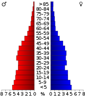
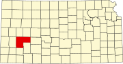
Holcomb is a city in Finney County, Kansas, United States. As of the 2020 census, the population of the city was 2,245. It is located south of Highway 50.

<span class="mw-page-title-main">Pierceville, Kansas</span> Unincorporated community in Finney County, Kansas

Pierceville is an unincorporated community in Finney County, Kansas, United States. As of the 2020 census, the population of the community and nearby areas was 98. It is located along U.S. Routes 50 and 400, 12 miles (19 km) southeast of Garden City.

References

  1. 1 2 3 "QuickFacts; Finney County, Kansas; Population, Census, 2020 & 2010". United States Census Bureau. Archived from the original on August 16, 2021. Retrieved August 16, 2021.
  2. "Find a County". National Association of Counties. Archived from the original on May 31, 2011. Retrieved June 7, 2011.
  3. 1 2 3 4 5 6 7 8 Blanchard, Leola Howard (1931). Conquest of Southwest Kansas: A History and Thrilling Stories of Frontier Life in the State of Kansas. Wichita Eagle Press.
  4. Gannett, Henry (1905). The Origin of Certain Place Names in the United States. Govt. Print. Off. pp.  126.
  5. Kansas Place-Names, John Rydjord, University of Oklahoma Press, 1972, ISBN   0-8061-0994-7
  6. Schoewe, Walter H. (1948). "The Geography of Kansas: Part I: Political Geography". Transactions of the Kansas Academy of Science. 51 (3): 253–288. doi:10.2307/3625831. ISSN   0022-8443. JSTOR   3625831.
  7. Callebs, Sean. "Whites become minority in Kansas county." CNN . May 22, 2009. Retrieved on May 24, 2009.
  8. "US Gazetteer files: 2010, 2000, and 1990". United States Census Bureau. February 12, 2011. Retrieved April 23, 2011.
  9. "Annual Estimates of the Resident Population for Counties: April 1, 2020 to July 1, 2023". United States Census Bureau. Retrieved April 3, 2024.
  10. "U.S. Decennial Census". United States Census Bureau. Retrieved July 24, 2014.
  11. "Historical Census Browser". University of Virginia Library. Archived from the original on May 30, 2019. Retrieved July 24, 2014.
  12. "Population of Counties by Decennial Census: 1900 to 1990". United States Census Bureau. Retrieved July 24, 2014.
  13. "Census 2000 PHC-T-4. Ranking Tables for Counties: 1990 and 2000" (PDF). United States Census Bureau. Archived (PDF) from the original on March 27, 2010. Retrieved July 24, 2014.
  14. 1 2 "U.S. Census website". United States Census Bureau . Retrieved January 31, 2008.
  15. "Dave Leip's Atlas of U.S. Presidential Elections".
  16. "Map of Wet and Dry Counties". Alcoholic Beverage Control, Kansas Department of Revenue. November 2006. Archived from the original on October 8, 2007. Retrieved December 28, 2007.
  17. 1 2 "General Highway Map of Finney County, Kansas" (PDF). Kansas Department of Transportation (KDOT). July 2007. Archived (PDF) from the original on June 2, 2023.
Notes

    Further reading

    County
    Other
    Maps

    38°01′N100°40′W / 38.017°N 100.667°W / 38.017; -100.667