
Bates County is a county located in the west central part of the U.S. state of Missouri, two counties south of the Missouri River. As of the 2010 census, the population was 17,049. Its county seat is Butler. The county was organized in 1841 and named after Frederick Bates, the second Governor of Missouri.

Osage County is a county located in the U.S. state of Kansas. As of the 2010 census, the county population was 16,295. Its county seat is Lyndon, and its most populous city is Osage City. The county was originally organized in 1855 as Weller County, and was renamed in 1859 after the Osage River that runs through it, which is itself named for the Osage Native American Tribe.

Miami County is a county located in east-central Kansas. As of the 2010 census, the county population was 32,787. Its county seat and most populous city is Paola.

Lyon County is a county located in the U.S. state of Kansas. As of the 2010 census, the county population was 33,690. The county seat and largest city is Emporia. The county was named for General Nathaniel Lyon, who was killed at the Battle of Wilson's Creek in the Civil War.

Franklin County is a county located in the eastern portion of the U.S. state of Kansas. As of the 2010 census, the county population was 25,992. Its county seat and most populous city is Ottawa. The county is predominantly rural. Formerly it was a part of the Kansas City metropolitan area, but was removed in 2013.

Osawatomie is a city in Miami County, Kansas, United States, 61 miles (98 km) southwest of Kansas City. As of the 2010 census, the city population was 4,447. It derives its name from two streams nearby, the Osage and Potawatomie.

Osage City is a city in Osage County, Kansas, United States. As of the 2010 census, the city population was 2,943.

Harveyville is a city in Wabaunsee County, Kansas, United States. As of the 2010 census, the city population was 236. It is 8.5 miles (13.7 km) northwest of the city of Burlingame.
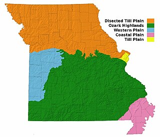
Missouri, a state near the geographical center of the United States, has three distinct physiographic divisions:

The Flint Hills, historically known as Bluestem Pastures or Blue Stem Hills, are a region in eastern Kansas and north-central Oklahoma named for the abundant residual flint eroded from the bedrock that lies near or at the surface. It consists of a band of hills stretching from Kansas to Oklahoma, extending from Marshall and Washington Counties in the north to Cowley County, Kansas and Kay and Osage Counties in Oklahoma in the south, to Geary and Shawnee Counties west to east. Oklahomans generally refer to the same geologic formation as the Osage Hills or "the Osage."

Green Country, sometimes referred to as Northeast Oklahoma, is the northeastern portion of the U.S. state of Oklahoma, which lies west of the northern half of Arkansas, the southwestern corner of Missouri, and south of Kansas.

The Marais des Cygnes River is a principal tributary of the Osage River, about 217 miles (349 km) long, in eastern Kansas and western Missouri in the United States. Via the Osage and Missouri rivers, it is part of the watershed of the Mississippi River.
The term Cross Timbers, also known as Ecoregion 29, Central Oklahoma/Texas Plains, is used to describe a strip of land in the United States that runs from southeastern Kansas across Central Oklahoma to Central Texas. Made up of a mix of prairie, savanna, and woodland, it forms part of the boundary between the more heavily forested eastern country and the almost treeless Great Plains, and also marks the western habitat limit of many mammals and insects.
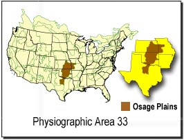
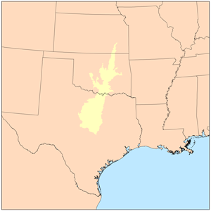
The Osage Plains are a physiographic section of the larger Central Lowland province, which in turn is part of the larger Interior Plains physiographic division. The area is sometimes called the Lower Plains, North Central Plains,or Rolling Plains. The Osage Plains, covering west-central Missouri, the southeastern third of Kansas, most of central Oklahoma, and extending into north-central Texas, is the southernmost of three tallgrass prairie physiographic areas. It grades into savanna and woodland to the east and south, and into shorter, mixed-grass prairie to the west. The Osage Plains consist of three subregions. The Osage Plains proper occupy the northeast segment. Although sharply demarcated from the Ozark uplift, the plains are nonetheless a transitional area across which the boundary between prairie and woodland has shifted over time. In the central portion of the physiographic area lies the second subregion, the Flint Hills, commonly called "the Osage" in Oklahoma. This large remnant core of native tallgrass prairie is a rocky rolling terrain that runs from north to south across Kansas and extends into Oklahoma. To the west and south of these hills are the Blackland Prairies and Cross Timbers. This vegetatively complex region of intermixed prairie and scrubby juniper-mesquite woodland extends into north-central Texas. Bluestem prairies and oak-dominated savannas and woodlands characterize the natural vegetation in the Cross Timbers. Much of the area has been converted to agriculture, although expanses of oak forest and woodland are still scattered throughout the eastern portion of the subregion.
Prairie Spirit Trail State Park is a rail trail that is a Kansas State Park.
Bayard is an unincorporated community in the northeastern part of Allen County, located in southeast Kansas, in the central United States of America. Although official populations are not compiled for unincorporated places, the population of the surrounding Osage Township was 316 in the 2000 census.

Marion Township is a township in Douglas County, Kansas, USA. As of the 2000 census, its population was 836. It was named after the former town of Marion which in turn was named after Francis Marion.

Palmyra Township is a township in Douglas County, Kansas, USA. As of the 2000 census, its population was 5,760. It was named after a small trail stop on the Santa Fe Trail that was later absorbed into Baldwin City. When it was first established in 1855, it was called Calhoun, until 1858.

John Redmond Reservoir is a reservoir on the Neosho River in eastern Kansas. Built and managed by the U.S. Army Corps of Engineers, it is used for flood control, recreation, water supply, and wildlife management. It borders the Flint Hills National Wildlife Refuge to the northwest.
Osage State Fishing Lake is located in northern Osage County, Kansas. It is a mile east of US 75. Scranton, Kansas, is to the lake's northwest and Overbrook, Kansas, is to the northeast. Osage Lake is a freshwater man-made lake, constructed in 1955. It has a surface area of 140 acres, The parkland in which the lake is contained has 366 acreas of land, mostly tall grass prairie with numerous wooded areas. The lake is owned by the State of Kansas.


