Gilbert Plains

Last updated

Gilbert Plains
Sacred Heart Ukrainian Catholic Church.jpg
Sacred Heart Ukrainian Catholic Church in Gilbert Plains, Manitoba.
Canada Manitoba location map 2.svg
Red pog.svg
Gilbert Plains
Location of Gilbert Plains in Manitoba
Coordinates: 51°08′52″N100°29′21″W / 51.14778°N 100.48917°W / 51.14778; -100.48917
Country Flag of Canada (Pantone).svg  Canada
Province Flag of Manitoba.svg  Manitoba
Municipality Gilbert Plains Municipality
Census Division No. 16
Government
   MP Dan Mazier
   MLA Ron Kostyshyn
Area
  Total2.70 km2 (1.04 sq mi)
Population
 (2016)
  Total785 [1]
  Density291/km2 (750/sq mi)
  Change 2011-16
Decrease2.svg3.2%
Time zone UTC−6 (CST)
  Summer (DST) UTC−5 (CDT)
Postal Code
R0L 0C1, ROL 0X0
Area code 204
Highways PTH 5
Railways Canadian National
NTS Map 62N1 Dauphin
GNBC CodeGBSLM [2]
Website
[1]

Gilbert Plains is an unincorporated urban community in the Gilbert Plains Municipality, Manitoba, Canada, that was classified as a town prior to January 1, 2015.

Contents

It is situated on the Valley River, in the Parkland Region between Riding Mountain National Park and Duck Mountain Provincial Park. [3]

Gilbert Plains was featured during season 3 of the CBC program Still Standing . [4] The episode originally aired on September 5, 2017.

History

Incorporated in 1906, the original townsite was some miles to the south. The community was named for Gilbert Ross, a Métis man who was living in the region when the first European settler, Glenlyon Campbell, arrived.

On 1 January 2015, the Town of Gilbert Plains relinquished its town status when it amalgamated with the Rural Municipality of Gilbert Plains to form the Gilbert Plains Municipality. [5]

Demographics

In the 2021 Census of Population conducted by Statistics Canada, Gilbert Plains had a population of 773 living in 356 of its 407 total private dwellings, a change of

Media

A local newspaper, The Exponent, serviced both Gilbert Plains and its neighboring town, Grandview. The Exponent closed on 24 February 2017, after 117 years of operation. [7]

A weekly non-profit newspaper, The Plain View, published its first issue on 5 June 2018, and has been running ever since. It serves both Gilbert Plains and Grandview.

Transportation

The community is located on Highway 5 and the CN railway line between Dauphin and Grandview, approximately 250 miles (400 km) northwest of Winnipeg. Gilbert Plains railway station receives Via Rail service. [8] The community previously had an airport. [9]

Preceding station VIA Rail Canada simplified.svg Via Rail Following station
Grandview
toward Churchill
Winnipeg–Churchill Dauphin
toward Winnipeg
Former services
Preceding station Canadian National Railway Following station
Grandview
toward Calgary
CalgaryWinnipeg Ashville
toward Winnipeg

Climate

Climate data for Gilbert Plains
MonthJanFebMarAprMayJunJulAugSepOctNovDecYear
Record high °C (°F)8.0
(46.4)
12.0
(53.6)
23.0
(73.4)
35.5
(95.9)
37.5
(99.5)
36.1
(97.0)
36.1
(97.0)
39.5
(103.1)
36.1
(97.0)
31.5
(88.7)
21.1
(70.0)
12.5
(54.5)
39.5
(103.1)
Mean daily maximum °C (°F)−11.0
(12.2)
−7.7
(18.1)
−0.9
(30.4)
9.6
(49.3)
17.4
(63.3)
22.1
(71.8)
25.3
(77.5)
24.4
(75.9)
17.8
(64.0)
10.0
(50.0)
−1.3
(29.7)
−8.8
(16.2)
8.1
(46.6)
Daily mean °C (°F)−16.6
(2.1)
−13.6
(7.5)
−6.9
(19.6)
3.0
(37.4)
10.3
(50.5)
15.6
(60.1)
18.5
(65.3)
17.2
(63.0)
11.1
(52.0)
4.0
(39.2)
−6.1
(21.0)
−13.9
(7.0)
1.9
(35.4)
Mean daily minimum °C (°F)−22.1
(−7.8)
−19.5
(−3.1)
−12.8
(9.0)
−3.6
(25.5)
3.1
(37.6)
9.0
(48.2)
11.6
(52.9)
9.9
(49.8)
4.3
(39.7)
−2.1
(28.2)
−10.8
(12.6)
−18.9
(−2.0)
−4.3
(24.3)
Record low °C (°F)−43.5
(−46.3)
−43.3
(−45.9)
−40.6
(−41.1)
−28.9
(−20.0)
−13.0
(8.6)
−3.5
(25.7)
−0.6
(30.9)
−1.5
(29.3)
−11.7
(10.9)
−20.0
(−4.0)
−38.9
(−38.0)
−40.0
(−40.0)
−43.5
(−46.3)
Average precipitation mm (inches)20.2
(0.80)
15.1
(0.59)
29.1
(1.15)
28.1
(1.11)
58.9
(2.32)
85.6
(3.37)
76.4
(3.01)
70.2
(2.76)
53.3
(2.10)
36.4
(1.43)
23.6
(0.93)
24.4
(0.96)
524.4
(20.65)
Average rainfall mm (inches)0.2
(0.01)
0.4
(0.02)
6.8
(0.27)
12.9
(0.51)
54.0
(2.13)
85.6
(3.37)
76.4
(3.01)
70.2
(2.76)
51.4
(2.02)
26.7
(1.05)
3.3
(0.13)
0.6
(0.02)
388.6
(15.30)
Average snowfall cm (inches)20.0
(7.9)
14.7
(5.8)
22.2
(8.7)
15.2
(6.0)
4.9
(1.9)
0.0
(0.0)
0.0
(0.0)
0.0
(0.0)
1.8
(0.7)
9.7
(3.8)
20.4
(8.0)
24.4
(9.6)
132.8
(52.3)
Source: Environment Canada [10]

See also

Related Research Articles

Grandview is an unincorporated urban community in the Grandview Municipality within the Canadian province of Manitoba that held town status prior to January 1, 2015. It is located 45 kilometres west of the City of Dauphin along the Valley River.

Bowsman is an unincorporated urban community in the Municipality of Minitonas – Bowsman, Manitoba, Canada.

<span class="mw-page-title-main">Gladstone, Manitoba</span> Unincorporated community in Manitoba, Canada

Gladstone is an unincorporated urban community in the Municipality of WestLake – Gladstone within the Canadian province of Manitoba that held town status prior to January 1, 2015. It is located on the Yellowhead Highway at the intersection with Highway 34. The Gladstone railway station receives Via Rail service.

<span class="mw-page-title-main">Rural Municipality of Sifton</span> Rural municipality in Manitoba, Canada

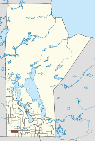
The Rural Municipality of Sifton is a rural municipality (RM) in the south-west portion of the Canadian province of Manitoba.

<span class="mw-page-title-main">Division No. 17, Manitoba</span> Census division in Manitoba, Canada

Census Division No. 17 (Dauphin) is a census division located within the Parklands Region of the province of Manitoba, Canada. Unlike in some other provinces, census divisions do not reflect the organization of local government in Manitoba. These areas exist solely for the purposes of statistical analysis and presentation; they have no government of their own.

<span class="mw-page-title-main">Rural Municipality of Grey</span> Rural municipality in Manitoba, Canada

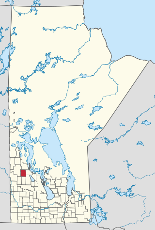
The Rural Municipality of Grey is a rural municipality in the Canadian province of Manitoba. It is named after Albert Grey, 4th Earl Grey, the former Governor General of Canada.

Shoal Lake is a locality in the southwest of Manitoba, Canada. Originally incorporated as a town, Shoal Lake amalgamated with the Rural Municipality of Shoal Lake on January 1, 2011 to form the Municipality of Shoal Lake, which became the Rural Municipality of Yellowhead on January 1, 2015.

<span class="mw-page-title-main">Municipality of Deloraine-Winchester</span> Rural municipality in Manitoba, Canada

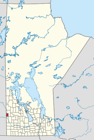
The Municipality of Deloraine – Winchester is a rural municipality (RM) in the Canadian province of Manitoba.

<span class="mw-page-title-main">Municipality of Ethelbert</span> Rural municipality in Manitoba, Canada

The Municipality of Ethelbert is a rural municipality (RM) in the Canadian province of Manitoba.

<span class="mw-page-title-main">Gilbert Plains Municipality</span> Rural municipality in Manitoba, Canada

Gilbert Plains Municipality is a rural municipality (RM) in the Canadian province of Manitoba.

<span class="mw-page-title-main">Grandview Municipality</span> Rural municipality in Manitoba, Canada

Grandview Municipality is a rural municipality (RM) in the Parkland Region of Manitoba, Canada. It is located in a valley between Duck Mountain Provincial Forest & Park and Riding Mountain National Park, which both lie partially within the RM's territory.

<span class="mw-page-title-main">Municipality of Grassland</span> Rural municipality in Manitoba, Canada

The Municipality of Grassland is a rural municipality (RM) in the Canadian province of Manitoba.

<span class="mw-page-title-main">Municipality of Minitonas–Bowsman</span> Rural municipality in Manitoba, Canada

The Municipality of Minitonas–Bowsman is a rural municipality (RM) in the Parkland Region of Manitoba, Canada. More precisely, it is located in the Swan Valley area.

<span class="mw-page-title-main">Municipality of Norfolk Treherne</span> Rural municipality in Manitoba, Canada

The Municipality of Norfolk Treherne is a rural municipality (RM) in the Canadian province of Manitoba.

<span class="mw-page-title-main">Municipality of Pembina</span> Rural municipality in Manitoba, Canada

The Municipality of Pembina is a rural municipality (RM) in the Canadian province of Manitoba.

<span class="mw-page-title-main">Riverdale Municipality</span> Rural municipality in Manitoba, Canada

Riverdale Municipality is a rural municipality (RM) in the Canadian province of Manitoba.

<span class="mw-page-title-main">Rossburn Municipality</span> Rural municipality in Manitoba, Canada

Rossburn Municipality is a rural municipality (RM) in the Parkland Region of Manitoba, Canada.

<span class="mw-page-title-main">Municipality of Russell-Binscarth</span> Rural municipality in Manitoba, Canada

The Municipality of Russell – Binscarth is a rural municipality (RM) in the Parkland Region of Manitoba, Canada. It is located in the far western part of the province and shares a border with the neighbouring province of Saskatchewan.

<span class="mw-page-title-main">Municipality of Souris-Glenwood</span> Rural municipality in Manitoba, Canada

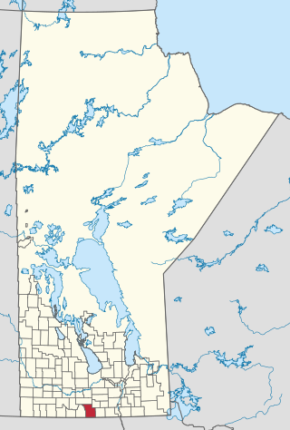
The Municipality of Souris-Glenwood is a rural municipality (RM) in the Canadian province of Manitoba.

<span class="mw-page-title-main">Municipality of Ste. Rose</span> Rural municipality in Manitoba, Canada

The Municipality of Ste. Rose is a rural municipality (RM) in the Canadian province of Manitoba.

References

  1. 1 2 "2016 census profile". Census Canada . Retrieved July 28, 2020.
  2. "Gilbert Plains". Geographical Names Data Base . Natural Resources Canada.
  3. "Maps: Gilbert Plains". Gilbert Plains Government. Retrieved October 4, 2020.
  4. "Still Standing, Season 3, Episode 12: Gilbert Plains, Manitoba". Canadian Broadcasting Corporation. Retrieved May 19, 2021.
  5. "The Municipal Amalgamations Act (C.C.S.M. c. M235): Town of Gilbert Plains and Rural Municipality of Gilbert Plains Amalgamation Regulation" (PDF). Government of Manitoba. Retrieved October 4, 2014.
  6. "Population and dwelling counts: Canada and designated places". Statistics Canada. February 9, 2022. Retrieved September 3, 2022.
  7. Clarke, Tyler (April 9, 2017). "Exponent closes after 117 years". The Brandon Sun. Retrieved October 4, 2020.
  8. "Gilbert Plains train station - VIA Rail". www.viarail.ca.
  9. "CJH2 - Airport". GCMap. Retrieved October 4, 2020.
  10. "Gilbert Plains". Canadian Climate Normals 1981–2010 (in English and French). Environment Canada. Retrieved September 23, 2015.