Souris, Manitoba

Last updated

Souris
Souris Manitoba Skyline crop.jpg
Souris Crescent Ave buildings.jpg
Hillcrest Museum.jpg
The Souris River.jpg
Souris Grain Elevators.jpg
From top, left to right: A view of the Souris skyline from Victoria Park, historic buildings on Crescent Avenue, Hillcrest Museum, the Souris River, and grain elevators in Souris.
Canada Manitoba location map 2.svg
Red pog.svg
Souris
Location of Souris, Manitoba
Canada location map 2.svg
Red pog.svg
Souris
Souris (Canada)
Coordinates: 49°37′02″N100°15′37″W / 49.61722°N 100.26028°W / 49.61722; -100.26028 [1]
CountryCanada
Province Manitoba
Municipality Souris-Glenwood
Established1881
Incorporated1903
Amalgamation2015
Government
  MLA Grant Jackson (PC)
  MP Larry Maguire (CPC)
Area
 (2021) [3]
  Land3.35 km2 (1.29 sq mi)
   Population centre 2.5 km2 (1.0 sq mi)
   Census subdivision (Souris-Glenwood)579.69 km2 (223.82 sq mi)
Elevation
 (at weather station) [4]
432.8 m (1,419.9 ft)
Population
 (2021) [3]
  Total1,970
  Density588.7/km2 (1,525/sq mi)
  Population centre
1,935
  Population centre density772.6/km2 (2,001/sq mi)
  Census subdivision
2,547
  Census subdivision density4.4/km2 (11/sq mi)
Demonym Sourisites
Time zone UTC−06:00 (CST)
  Summer (DST) UTC−05:00 (CDT)
Postal code
Area code(s) 204
Website www.sourismanitoba.com

Souris (2021 population: 1,970 [3] ) is an unincorporated urban community in the Municipality of Souris-Glenwood within the Canadian province of Manitoba that held town status prior to the Manitoba municipal amalgamations on January 1, 2015. It is located within the municipality at the confluence of Plum Creek and Souris River, from which it takes its name. Before 1882, the town was called Plum Creek. [5]

Contents

The community is home to Canada's longest historic cable-stayed footbridge at 177 m (581 ft) long, [6] known as the Swinging Bridge, which spans the Souris River that divides the community. The Swinging Bridge was built in 1904 as a means of transportation over the Souris River, later floods destroyed the original swinging bridge and in 2013 a modern cable bridge was installed. [7]

History

The area of Souris was first explored by Europeans when La Vérendrye arrived in 1738, when it seems he initially mistook the Souris River for the Missouri River. [8] The area of the townsite was later explored by David Thompson in 1797-98 and Alexander Henry the younger in 1805. [8] Detailed accounts of life on the Souris plains in the early 1800s were diarized in detail by a Captain John Rogers. His diaries remain saved with the Government of Manitoba's Archive Division today. [8] Rogers was later killed in the Battle of Seven Oaks, ending his exploration of the area. [8] In the years after, considerable fur trade continued in the area, documented by Peter Garrioch in 1843-44. [8] Buffalo still roamed these plains in the early 1800s before the herds were killed out. [8]

From the mid-century to the late 1800s, only the Assiniboine roamed these areas. The first permanent settlers to the area arrived in 1880 when Captain Gilbert Wood, his wife, and two children came to the area. [8] They travelled to Winnipeg by way of Chicago, from there they took a buckboard wagon west, pulled by oxen while a steamship carried their goods up the Assiniboine River. [8] Captain Wood had heard of a man named Lang who told him the land at Plum Creek and the Souris River was a beautiful place to settle. Wood, curious by this notion, hired a guide by the name of Bangs and they set out to see the area for themselves. [8] This resulted in a 3-4 day round trip from their camp at Millford which is on the south bank of the Assiniboine at Treesbank. When they returned his wife asked him what he thought of the area, to which he replied that it was a beautiful district, the best he had seen in all their journeys. [8] To this Mrs. Wood replied "Then take me to Plum Creek." [8]

They would arrive to the area on August 28, 1880. While setting up a homestead there they encountered a man, Squire Sowden from Millbrook, Ontario. [8] Sowden was shocked to find a woman and children in what was then the middle of nowhere. [8] The Woods would build a shanty on the shores of Plum Creek that would serve as a landing place for many new settlers to the area. Mrs. Wood later recounted a time when as many as 21 people were sleeping in their 3.7 m × 4.9 m (12 ft × 16 ft) sod shanty. Captain Wood lived until 1903 while Mrs. Wood died in 1928. [8]

The first large settlement was led by Squire Sowden. In 1880 he was appointed head of a Colonization Syndicate in Millbrook by a group of businessmen looking to settle the area. He explored the area of Plum Creek at Souris, adventuring as far west as today's Gainsborough, Saskatchewan. [8] This is the time when Squire met the Woods, while exploring the area in early fall 1880. The sites were good and he selected several surveyed townships for their future settlement. Sowden and the businessmen sent a proposal to Ottawa which was accepted and the venture was begun. [8] Sowden and the men arranged for land to be purchased at $3.00 an acre and each settler paid $25.00 for a receipt which was to be presented at the Land Office at the mouth of the Souris River when they completed their registration. [8] The settlers travelled from Ontario to Detroit by train, then travelling from there to Chicago, next to Saint Paul, Minnesota, before eventually reaching Saint Boniface, Manitoba. [8] Here they would travel the rough roads west by cart and storing their heavier goods until they could be shipped to the mouth of the Souris River when navigable. [8] When the settlers reached the land at last, they saw the land was good and set to work establishing their homesteads. [8]

The first building in the town was erected in 1881. The next few years saw the townsite continue to grow as more and more settlers reached the area. Many of the settlers returned home the first winter in 1881 to Ontario, but the following year they returned with more goods, and many more settlers followed them. [8] The town grew at an exceptional rate in 1882. [8] Many of the settlers were now arriving at the town from Brandon via the Canadian Pacific Railway rather than the Boundary Commission Trail located to the south. [8] Many of the settlers were coming from the "old countries" of the United Kingdom and particularly from Ireland. [8]

Sowden had originally chosen the Plum Creek site because he wanted to build a mill there and this he completed in those early years. [8] The mill was successful and despite drought years in that decade, the products of the mill became quite popular in the area and country. [8] As the grain became popular, local farmers would have to bring their wheat to Brandon or Alexander as there was no rail service in Souris. Beginning in 1890 negotiations were made with the Canadian Pacific Railway (CPR) to bring the railway to the town and in 1892 the Glenboro Line was completed to the town. This brought further and increased growth to the community as many towns of the era hitched their prosperity to the railway. Before the turn of the century five grain elevators stood alongside the railway. In 1902 a brickyard was established in the community, it only operated for a few short years, but 40 of the town's major brick commercial and residential buildings were built by these bricks. [8] Many of these buildings are still standing today. As a result of this exceptional growth, the community was incorporated as a town in 1904 as the population neared a thousand people. [8]

Geography

Souris is located at the conjunction of Plum Creek and the Souris River on the Canadian Prairies. A dam lies at the east of town on the Souris River in order to maintain recreational usage water levels. In the past the dam was meant to keep waters high enough for operation of the flour mill. With Souris residing in Palliser's Triangle the region can be prone to regular and lengthy droughts. The city of Brandon is located 30 km (19 mi) to the northeast. Souris lies between the Brandon Hills located to the northeast and the Turtle Mountain Plateau located approximately 80 km (50 mi) south of the town. Whitewater Lake, an endorheic basin lies between the Turtle Mountains and the town.

Climate data for Souris
Climate ID: 5012719; coordinates 49°39′N100°15′W / 49.650°N 100.250°W / 49.650; -100.250 (Souris) ; elevation: 432.8 m (1,420 ft); 1991–2020 normals
MonthJanFebMarAprMayJunJulAugSepOctNovDecYear
Record high °C (°F)8.0
(46.4)
16.0
(60.8)
17.5
(63.5)
30.0
(86.0)
34.5
(94.1)
36.0
(96.8)
35.0
(95.0)
39.0
(102.2)
36.0
(96.8)
31.5
(88.7)
20.0
(68.0)
9.0
(48.2)
39.0
(102.2)
Mean daily maximum °C (°F)−10.3
(13.5)
−7.1
(19.2)
−0.3
(31.5)
10.8
(51.4)
18.4
(65.1)
22.8
(73.0)
25.5
(77.9)
25.5
(77.9)
19.2
(66.6)
10.9
(51.6)
−0.8
(30.6)
−8.2
(17.2)
8.9
(48.0)
Daily mean °C (°F)−16
(3)
−13
(9)
−5.8
(21.6)
4.2
(39.6)
11.1
(52.0)
16.3
(61.3)
18.6
(65.5)
18.0
(64.4)
12.0
(53.6)
4.4
(39.9)
−5.9
(21.4)
−13.7
(7.3)
2.5
(36.5)
Mean daily minimum °C (°F)−21.6
(−6.9)
−18.8
(−1.8)
−11.3
(11.7)
−2.4
(27.7)
3.8
(38.8)
9.7
(49.5)
11.7
(53.1)
10.4
(50.7)
4.7
(40.5)
−2.2
(28.0)
−10.8
(12.6)
−19.1
(−2.4)
−3.8
(25.2)
Record low °C (°F)−45
(−49)
−42.5
(−44.5)
−40
(−40)
−22.5
(−8.5)
−12.5
(9.5)
−3
(27)
0.0
(32.0)
−3.5
(25.7)
−8
(18)
−25
(−13)
−34
(−29)
−43
(−45)
−45
(−49)
Average precipitation mm (inches)23.5
(0.93)
17.5
(0.69)
26.1
(1.03)
27.5
(1.08)
64.9
(2.56)
92.1
(3.63)
72.6
(2.86)
54.5
(2.15)
41.6
(1.64)
35.2
(1.39)
24.7
(0.97)
28.5
(1.12)
508.8
(20.03)
Average rainfall mm (inches)0.6
(0.02)
1.3
(0.05)
7.7
(0.30)
16.6
(0.65)
57.2
(2.25)
92.1
(3.63)
72.6
(2.86)
54.5
(2.15)
41.3
(1.63)
26.5
(1.04)
6.2
(0.24)
0.8
(0.03)
377.4
(14.86)
Average snowfall cm (inches)23.0
(9.1)
16.2
(6.4)
18.3
(7.2)
10.8
(4.3)
5.6
(2.2)
0.0
(0.0)
0.0
(0.0)
0.0
(0.0)
0.3
(0.1)
8.6
(3.4)
18.5
(7.3)
27.7
(10.9)
129.0
(50.8)
Average precipitation days (≥ 0.2 mm)7.34.75.96.210.212.710.49.28.78.15.67.696.5
Average rainy days (≥ 0.2 mm)0.220.271.64.39.812.710.49.28.66.71.40.5565.7
Average snowy days (≥ 0.2 cm)7.24.54.62.50.80.00.00.00.11.84.67.033.1
Source: Environment and Climate Change Canada [4]

Economy

As a small agrarian town, about 28% of the town's jobs are located in the agricultural sector, the second largest sector is the health and social assistance sector making up 20% of Souris jobs, and education makes up the third largest group at 10% of local area jobs. [9] Statistically the economy appears healthy in the Souris region with job growth from 2014-19 showing a 23.5% increase with 346 new jobs created over the five-year period. [9] Average household income in the community is $68,000, below both the provincial ($79,500) and the municipality ($72,500) averages. [3] Agriculture in the region is led by growing crops such as wheat, corn, canola, and soybeans. [10] Livestock is also important in the town's agricultural economic region with cattle, swine, and sheep being farmed commercially in the Souris area. [10]

Demographics

Historical population
YearPop.±%
1901839    
19111,854+121.0%
19211,710−7.8%
19311,661−2.9%
19411,346−19.0%
19511,584+17.7%
19611,841+16.2%
1996 1,613−12.4%
2001 1,683+4.3%
2006 1,772+5.3%
2011 1,716−3.2%
2016 1,974+15.0%
2021 1,970−0.2%
The large positive population trend in 2011-2016 is a result of a change in the census assessment area. [3] [11] [12] [13]

In the 2021 Canadian census conducted by Statistics Canada, Souris had a population of 1,970 living in 871 of its 960 total private dwellings, a change of

Bridge over the Souris River at Souris, Manitoba. It spans 184 m (604 ft) and has a weight capacity of 925 white-tailed deer. This bridge was built in 2013 to replace the bridge that was demolished in 2011 due to flooding. The first suspension bridge at Souris was erected in 1904. Souris Swinging Bridge.jpg
Bridge over the Souris River at Souris, Manitoba. It spans 184 m (604 ft) and has a weight capacity of 925 white-tailed deer. This bridge was built in 2013 to replace the bridge that was demolished in 2011 due to flooding. The first suspension bridge at Souris was erected in 1904.

Attractions

The Souris Swinging Bridge was destroyed in the 1976 flood and again in the flood of 2011. A new, higher, swinging bridge opened during the summer of 2013. [14] [15] A new swimming pool was constructed in 2010 and is located in Victoria Park, along with numerous walking trails and a bird sanctuary known for its flock of peacocks.

Sports

Souris is home to the Southwest Cougars, an ice hockey team which plays in the Manitoba U-18 'AAA' Hockey League. [16] It is also home of the Souris Sabres, which is part of the Souris School athletics program, and a member of the Manitoba High School Athletic Association.They participate in 15 sports, including; hockey, basketball, volleyball, football, and rugby. [17]

Another local hockey team is the Souris Elks, which is a senior team in the Tiger Hills Hockey League. [18]

Notable people

Related Research Articles

<span class="mw-page-title-main">Weyburn</span> City in Saskatchewan, Canada

Weyburn is the tenth-largest city in Saskatchewan, Canada. The city has a population of 11,019. It is on the Souris River 110 kilometres (68 mi) southeast of the provincial capital of Regina and is 70 kilometres (43 mi) north from the North Dakota border in the United States. The name is reputedly a corruption of the Scottish "wee burn," referring to a small creek. The city is surrounded by the Rural Municipality of Weyburn No. 67.

<span class="mw-page-title-main">Brandon, Manitoba</span> City in Manitoba, Canada

Brandon is the second-largest city in the province of Manitoba, Canada. It is located in the southwestern corner of the province on the banks of the Assiniboine River, approximately 214 km (133 mi) west of the provincial capital, Winnipeg, and 120 km (75 mi) east of the Saskatchewan border. Brandon covers an area of 77.41 km2 (29.89 sq mi) with a population of 51,313, and a census metropolitan area population of 54,268. It is the primary hub of trade and commerce for the Westman Region as well as parts of southeastern Saskatchewan and northern North Dakota, an area with a population of over 190,000 people.

<span class="mw-page-title-main">Souris River</span> River in Canada and the United States

The Souris River or Mouse River is a river in central North America. Approximately 435 miles (700 km) in length, it drains about 23,600 square miles (61,100 km2) in Canada and the United States.

<span class="mw-page-title-main">Deloraine, Manitoba</span> Place in Manitoba, Canada

Deloraine is an unincorporated urban community in the Municipality of Deloraine – Winchester within the Canadian province of Manitoba that held town status prior to January 1, 2015. It is situated near the Turtle Mountains in the southwestern corner of the province. Located in the Westman Region, the community is 100 km (62 mi) south of Brandon. Deloraine originally incorporated as a village in 1904 and then as a town in 1907. Its town status was relinquished in 2015 when it amalgamated with the Rural Municipality of Winchester.

<span class="mw-page-title-main">Melita, Manitoba</span> Town in Manitoba, Canada

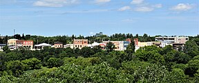
Melita is a town located in the south-western corner of the Canadian province of Manitoba. It is surrounded by the Municipality of Two Borders and occupies a bend of the Souris River. Graham Creek runs along the west side of town and into the Souris River. The population at the 2016 census was 1,042. It sits at the junction of Highways 3 and 83, approximately 320 km southwest of Winnipeg. Melita is known as the "Grasslands Bird Capital of Manitoba" and is located in Manitoba's banana belt.

<span class="mw-page-title-main">Minnedosa, Manitoba</span> Town in Manitoba, Canada

Minnedosa is a town in the southwestern part of the Canadian province of Manitoba situated 50 kilometres (32 mi) north of Brandon, Manitoba on the Little Saskatchewan River. The town's name means "flowing water" in the Dakota language. The population of Minnedosa reported in the 2021 Canadian Census was 2,741. The town is surrounded by the Rural Municipality of Minto – Odanah.

<span class="mw-page-title-main">St. James-Assiniboia, Winnipeg</span> Suburb in Winnipeg, Manitoba, Canada

St. James-Assiniboia is a major community area in Winnipeg, Manitoba, Canada. As it encapsulates most of the city ward of St. James, which includes the major St. James Street, the area itself is often simply referred to "St. James."

<span class="mw-page-title-main">Carberry, Manitoba</span> Town in Manitoba, Canada

Carberry is a town in southwestern Manitoba, Canada. It is situated 3 kilometres (1.9 mi) south of the Trans-Canada Highway on Highway 5 in the Municipality of North Cypress – Langford, and has a population of 1,818 people.

<span class="mw-page-title-main">Neepawa</span> Town in Manitoba, Canada

Neepawa is a town in Manitoba, Canada, located on the Yellowhead Highway at the intersection with Highway 5.

Glenboro is an unincorporated urban community in the Municipality of Glenboro – South Cypress within the Canadian province of Manitoba that held village status prior to January 1, 2015. it is located about 80 km southeast of the City of Brandon. In the 2021 census it had a population of 1,123. The community is a service centre for the surrounding farming community.

<span class="mw-page-title-main">Oak Lake, Manitoba</span> Place in Manitoba, Canada

Oak Lake is an unincorporated urban community in the Rural Municipality of Sifton within the Canadian province of Manitoba that held town status prior to January 1, 2015. It is located 52 km (32 mi) west of Brandon along the Trans-Canada Highway. The lake after which it was named is in the rural municipality's western area.

<span class="mw-page-title-main">Wawanesa, Manitoba</span> Unincorporated urban community in Manitoba, Canada

Wawanesa is an unincorporated urban community in the Municipality of Oakland – Wawanesa within the Canadian province of Manitoba that held village status before January 1, 2015. It is the birthplace of The Wawanesa Mutual Insurance Co.

The Rural Municipality of Glenwood is a former rural municipality (RM) in the Canadian province of Manitoba. It was originally incorporated as a rural municipality on December 22, 1883. It ceased on January 1, 2015 as a result of its provincially mandated amalgamation with the Town of Souris to form the Municipality of Souris – Glenwood.

<span class="mw-page-title-main">Rural Municipality of Sifton</span> Rural municipality in Manitoba, Canada

The Rural Municipality of Sifton is a rural municipality (RM) in the south-west portion of the Canadian province of Manitoba.

The Manitoba Watershed District Program is a provincial-municipal partnership directed to the conservation and management of water and soil resources. There are 14 watershed districts including more than 130 municipalities covering almost all of the agricultural areas of Manitoba, Canada. The Province provides substantial funding and general guidance but the programs are developed and administered locally. The districts spend more than $8 million each year on a wide variety of conservation programs.

<span class="mw-page-title-main">Spruce Woods (electoral district)</span> Provincial electoral district in Manitoba, Canada

Spruce Woods is a provincial electoral division in the Canadian province of Manitoba. It was created by redistribution in 2008 out of parts of Minnedosa and Turtle Mountain and notably gained parts of the City of Brandon and Arthur-Virden in the 2018 redistribution.

Broomhill is a community in the Municipality of Two Borders, Manitoba, Canada. The community is located on Highway 345 between the communities of Tilston and Bede, approximately 124 km south-west of Brandon, Manitoba only 25 km north-west of the Town of Melita. The town was named for the abundance of Broom plants that were seen growing on the sandhills in the area. This area is commonly known for its rare mix of grasslands and wildlife.

<span class="mw-page-title-main">Municipality of Souris-Glenwood</span> Rural municipality in Manitoba, Canada

The Municipality of Souris-Glenwood is a rural municipality (RM) in the Canadian province of Manitoba.

<span class="mw-page-title-main">Oak Lake (Manitoba)</span> Lake in Manitoba, Canada

Oak Lake is a lake in the south-western part of the Canadian province of Manitoba in a region called Westman. Oak Lake is a kettle lake and is an aquifer supplier for numerous nearby residential areas and farms. The lake is in the RM of Sifton and sits at an elevation of 426 metres above sea level. Provincial Road 254 provides access to the lake.

<span class="mw-page-title-main">Plum Creek (Manitoba)</span> River in Manitoba

Plum Creek is the primary outflow for the Plum Lakes and travels in an easterly direction for about 28 kilometres until it meets up with the Souris River, which is part of the Hudson Bay drainage basin, at the community of Souris in the Canadian province of Manitoba. Plum Lakes and the beginning of Plum Creek are in the Rural Municipality of Sifton and the mouth is in the Municipality of Souris – Glenwood.

References

  1. "Souris". Geographical Names Data Base . Natural Resources Canada.
  2. "Souris". Geographical Names Data Base . Natural Resources Canada.
  3. 1 2 3 4 5 6 "Census Profile, 2021 Census of Population - Profile table. Souris, Dissolved municipality (DMU), Manitoba [Designated place]; Souris, Manitoba [Population centre]; Souris-Glenwood, Municipality (MU), Manitoba [Census subdivision]; Manitoba [Province]". Statistics Canada . February 1, 2023. Retrieved May 8, 2024.
  4. 1 2 "Canadian Climate Normals 1981–2010". Environment and Climate Change Canada. March 27, 2024. Retrieved May 8, 2024.
  5. Hamilton, William (1978). The Macmillan Book of Canadian Place Names. Toronto: Macmillan. p. 65. ISBN   0-7715-9754-1.
  6. Encyclopedia of Manitoba (Winnipeg: Great Plains Publications, 2007), p. 648.
  7. "Manitoba town cuts historic footbridge to save dike". CTVNews.
  8. 1 2 3 4 5 6 7 8 9 10 11 12 13 14 15 16 17 18 19 20 21 22 23 24 25 26 27 28 The Souris Plains: From Pemmican to Wheat (PDF). 1956.
  9. 1 2 "Souris and Region Economic Profile" (PDF). Government of Manitoba . Retrieved July 25, 2022.
  10. 1 2 "Souris-Glenwood - Agriculture". Municipality of Souris – Glenwood . Retrieved July 25, 2022.
  11. Censuses 1871-1931
  12. Census 1941-1951
  13. Census 1961
  14. "Souris Swinging Bridge | Souris Manitoba".
  15. "The Souris Swinging Bridge, Canada's longest footbridge - Filipino Journal".
  16. "Southwest Cougars" . Retrieved May 8, 2024.
  17. "Souris Sabres" . Retrieved May 8, 2024.
  18. "Souris Elks" . Retrieved May 8, 2023.