
Uxbridge is a London Underground station in Uxbridge in the London Borough of Hillingdon, West London. The station is the terminus of the Uxbridge branches of both the Metropolitan line and the Piccadilly line. The next station towards London is Hillingdon. The station is 15.5 miles (25 km) west of Charing Cross and is in Travelcard Zone 6. The closest station on the Chiltern Line and Central line is West Ruislip, accessible by the U1 and U10 buses. The closest station on the Elizabeth line is West Drayton, accessible by the U1, U3, U5 and 222 buses. Uxbridge was formerly the terminus of a branch of the District line which ran from Ealing Common; the Piccadilly line took over in 1933.

East Croydon is a railway station and tram stop in Croydon, Greater London, England, and is located in Travelcard Zone 5. At 10 miles 28 chains from London Bridge, it is the 17th busiest station in Britain, was the 10th busiest in 2020–21, and is one of the busiest non-terminal stations in the country. It is one of three railway stations in the London Borough of Croydon with Croydon in their name, the others being West Croydon and South Croydon. A Tramlink tram stop is located immediately outside the main station entrance.

The University of Gloucestershire is a public university based in Gloucestershire, England. It is located over three campuses, two in Cheltenham and one in Gloucester. In March 2021, the university purchased the former Debenhams store in Gloucester City Centre, with a new campus due to open there in 2023.

Adelaide Metro is the public transport system of Adelaide, the capital city of South Australia. It is an intermodal system offering an integrated network of bus, tram, and train services throughout the metropolitan area. The network has an annual patronage of 79.9 million, of which 51 million journeys are by bus, 15.6 million by train, and 9.4 million by tram. The system has evolved heavily over the past fifteen years, and patronage increased dramatically during the 2014–15 period, a 5.5 percent increase on the 2013 figures due to electrification of frequented lines.

Acton Turville is a parish in the Cotswold Edge ward within South Gloucestershire, England. It lies 17 miles (27 km) east-northeast of Bristol and 93 miles (150 km) due west of London, with the M4 south of the parish. Acton Turville consists of a cluster of households across 1,009 acres, with a total population of 370 people. Acton Turville is also listed as "Achetone" in the Domesday Book.

Beverly Hills railway station is a heritage-listed former railway bridge and now railway station located on the East Hills line, serving the Sydney suburb of Beverly Hills in the Georges River Council local government area of New South Wales, Australia. The station is served by Sydney Trains T8 Airport & South line services. The station was designed and built by the NSW Government Railways. It is also known as the Beverly Hills Railway Station group and Dumbleton Railway Station. The property was added to the New South Wales State Heritage Register on 2 April 1999.
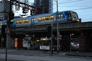
Transport in Melbourne, the state capital of Victoria, Australia, consists of several interlinking modes. Melbourne is a hub for intercity, intracity and regional travel. Road-based transport accounts for most trips across many parts of the city, facilitated by Australia's largest freeway network. Public transport, including the world's largest tram network, trains and buses, also forms a key part of the transport system. Other dominant modes include walking, cycling and commercial-passenger vehicle services such as taxis.
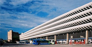
Preston bus station is the central bus station in the city of Preston in Lancashire, England. It was built by Ove Arup and Partners in the Brutalist architectural style between 1968 and 1969, to a design by Keith Ingham and Charles Wilson of Building Design Partnership with E. H. Stazicker.

The metropolitan area of Adelaide, South Australia is served by a wide variety of transport. Being centrally located on the Australian mainland, it forms a hub for east–west and north–south routes. The road network includes major expressways such as the Southern Expressway, the South Eastern Freeway, the Port River Expressway, the Northern Expressway and the South Road Superway. The city also has a public transport system managed by Adelaide Metro, consisting of a contracted bus system including the O-Bahn Busway, six metropolitan railway lines, and the Glenelg-Adelaide-Hindmarsh Tram. According to a study conducted by the Australian Bureau of Statistics, Adelaide has the highest passenger vehicle travel to work (84%) and the second lowest proportion of people walking to work (2.9%)–something that is being combated by the South Australian government in an effort to increase citizen ridership and use of public transport.

Altrincham Interchange is a transport hub in Altrincham, Greater Manchester, England. It consists of a bus station on Stamford New Road, a Northern Trains-operated heavy rail station on the Mid-Cheshire Line, and a light rail stop which forms the terminus of Manchester Metrolink's Altrincham line. The original heavy rail element of the station was opened by the Manchester, South Junction and Altrincham Railway as Altrincham and Bowdon railway station in April 1881, changing to Altrincham railway station in May 1974. The Metrolink element opened in June 1992. The Interchange underwent a complete redevelopment, at a cost of £19 million, starting in mid-July 2013. The new bus station opened officially on 7 December 2014.
Bristol is a city in south west England, near the Bristol Channel coast, approximately 106 miles (170 km) west of London. Several factors have influenced the development of its transport network. It is a major centre of employment, retail, culture and higher education, has many historic areas, and has a history of maritime industry. The city has a population of 450,000, with a metropolitan area of 650,000, and lies at the centre of the former County of Avon, which includes many dormitory towns, and has a population of one million.

The transport infrastructure of Greater Manchester is built up of numerous transport modes and forms an integral part of the structure of Greater Manchester and North West England – the most populated region outside of South East England which had approximately 301 million annual passenger journeys using either buses, planes, trains or trams in 2014. Its position as a national city of commerce, education and cultural importance means the city has one of the largest and most thorough transport infrastructures which is heavily relied upon by its 2.8 million inhabitants in the Greater Manchester conurbation and further afield in the North West region. Public transport comes under the jurisdiction of Transport for Greater Manchester.

The Strasbourg tramway, run by the CTS, is a network of six tramlines, A, B, C, D, E and F that operate in the cities of Strasbourg in Alsace, France, and Kehl in Baden-Württemberg, Germany. It is one of the few tram networks to cross an international border, along with the trams of Basel and Geneva. The first tramline in Strasbourg, which was originally horse-drawn, opened in 1878. After 1894, when an electric-powered tram system was introduced, a widespread network of tramways was built, including several longer-distance lines on both sides of the Rhine.

Public transport in Auckland, the largest metropolitan area of New Zealand, consists of three modes: bus, train and ferry. Services are coordinated by Auckland Transport under the AT Metro brand. Waitematā railway station is the main transport hub.

Central Park is a tram stop on the Oldham and Rochdale Line (ORL) of Greater Manchester's light rail Metrolink system. It opened to passengers on 13 June 2012 as part of Phase 3a of Metrolink's expansion, and is located in the Newton Heath area of Manchester, England.

MetroWest, formerly known as the Greater Bristol Metro, is a project to improve the rail services in Bristol, England, and the surrounding region. It was first proposed at First Great Western's Stakeholder Event in March 2008. The aim of the project is to develop half-hourly services through central Bristol which will also serve the surrounding West of England region. Transport campaigning groups Friends of Suburban Bristol Railways (FoSBR) and Transport for Greater Bristol are actively supporting the proposal, as are the three unitary authorities under the West of England Combined Authority and North Somerset Council.

Bristol Supertram was a proposed light rail system for the Bristol and South Gloucestershire regions of England. In 2001, the project was given backing from the government to build a line that would link the city centre with the North Bristol region, but the project was cancelled in 2004.
The city of Bristol in the United Kingdom has included a light rail transport system in its plans from the 1980s onwards. There has been no light rail in the city since the closure of Bristol Tramways in 1941.
The North Wales Metro is a rail and bus transport improvement programme in north Wales. Styled as a "Metro", it is conceptually a multi-modal system with a combination of bus, heavy rail, and light rail services. It was initially focused on linking major settlements and employment areas of the north-east of Wales with the North West of England, with its hubs located in Wrexham, Chester and Deeside, although the programme has since expanded, with proposals extending to Anglesey in the north-west of Wales. The existing Borderlands line forms a core rail component of the network, where projects to increase connections, integrated access, and service frequency between Wrexham, Deeside and Liverpool are centred upon. The proposals were put forward in 2016 as is part of Welsh Labour's plan for north Wales. Labour has pledged to open the system by 2035. The proposals were included in the 2018 Wales & Borders franchise contest. It is the second of the three regional metros proposed by the Welsh Government to go ahead, after the South Wales Metro, and before the Swansea Bay and West Wales Metro. The project is described to be in its initial phases.

Gloucester Quays is an outlet shopping centre on St Ann Way, Gloucester, in the area of the city formerly known as High Orchard. The outlet is situated close to Gloucester Docks, a historic area of the city.


