Kings Walk Shopping Centre

Last updated

Kings Walk Shopping Centre
Kings Walk Shopping Centre (5).jpg
Kings Walk Shopping Centre
Location Gloucester, England
Coordinates 51°51′53″N2°14′42″W / 51.8646334°N 2.24505711°W / 51.8646334; -2.24505711
Address37-41 Clarence Street
Opening date1969 - 1972
Developer Gloucester City Council (Land), Aviva Investors (Shops)
OwnerReef Estates
No. of stores and services29
No. of floors1
Parking290 spaces (16 Disabled spaces) [1]
Website kingswalk.co.uk

Kings Walk Shopping Centre is a single-storey indoor shopping centre in Gloucester, England. Built between 1969 and 1972, [2] it is part of the Kings Quarter development that includes an outdoor pedestrianised area. [3] [4]

Contents

Beneath a trapdoor in the centre is the Kings Walk Bastion, the remains of a 1,900 year old Roman city wall and tower.

History

Before it became a shopping centre, it was called Kings Street. This was primarily an industrial area and included a factory, which was built in 1873, for the printer John Bellows. This area was gradually commercialised with a lot of rebuilding done after the First World War between the 1920s and the 1930s. The north part of Kings Street was demolished in the 1920s when Kings Square was built. [5] One of the largest commercial developments took place between 1927 and 1929 and involved the creation of The Oxbode and Kings Square. It also involved the demolition of the many buildings in St Aldate Street, Kings Street and New Inn Lane, making room for new commercial buildings. Kings Square was enlarged in the 1960s and the space was made for the Kings Walk Shopping Centre to be developed. [3] In a large redevelopment of central Gloucester between 1969 and 1972 which involved Kings Street, Kings Square, Dog Lane and Clarence Street, shops were built on both sides of Kings Street and it was covered becoming pedestrianised indoor area called Kings Walk. [4] Eastgate House, an Adamish stone fronted building, was demolished when the shopping centre was developed. [6] A rooftop car park was built over the shopping centre. A pedestrian footbridge on the second floor spanned over Eastgate Street to link the Eastgate Shopping Centre and Kings Walk however, this has now been closed off. [7] [8]

In June 2016, the investment firm Vixcroft made a bid to buy the shopping centre from Aviva Investors, who have owned the shopping centre since 1969, for £25 Million. However, due to a clause in the contract regarding Brexit the deal fell through. In July 2017, Reef Estates approached Aviva Investments and successfully completed a deal to buy the shopping centre. [9] [10]

In March 2018, it was announced that £12 million would be invested to reface the shopping centre and remodel shopfronts in Kings Square and Eastgate Street. The work is planned to be completed by 2020. [11]

Kings Walk Bastion

Sideways view of the trapdoor to Kings Walk Bastion in Kings Walk Shopping Centre Kings Walk Shopping Centre (3).jpg
Sideways view of the trapdoor to Kings Walk Bastion in Kings Walk Shopping Centre

The Kings Walk Bastion is a 1,900 year old Roman city wall and tower, located beneath a trapdoor in the Kings Walk Shopping Centre. The earliest part of the bastion is thought to be a Roman fortress built around 60AD. Originally the bastion consisted of a sand and clay rampart with a wooden tower and a defensive ditch. At the end of the first century, the fortress was decommissioned so a new city could be built. This was intended to be a Roman Colonia. Stone parts of the bastion were built in the 3rd and 4th centuries, from Cotswold limestone. This wall was approximately five metres high and three metres wide and made part of the wall that surrounded the whole city at the time. The fourth century sections of the wall consist of massive blocks of stone with small rectangular holes on the inside where scaffolding would have been set. A semi-circular tower was added in the thirteenth century on the outside of the wall. [12] [13]

Archaeologists began investigations in Kings Square in 1934, where they found the corner of a Roman city wall and remains of a medieval tower 2 to 3 metres underground. The site under Kings Street and Kings Square was fully excavated by archaeologists between May and June 1969 before the redevelopment of Kings Street. In 1975, the site was opened to the public however it had to be closed in the mid-1990s due to underground flooding. In 2016, the Gloucester city council restored electricity to the site, installed a pump and lighting. [12] Then on the 8 September 2016 the site was reopened to the public. [14] It is thought that the remains of a Postern Gate are also located under Kings Walk but the exact location of the gate is still unknown. [3]

Related Research Articles

<span class="mw-page-title-main">Gloucester</span> City and non-metropolitan district in England

Gloucester is a cathedral city and the county town of Gloucestershire in the South West of England. Gloucester lies on the River Severn, between the Cotswolds to the east and the Forest of Dean to the west, 19 miles (31 km) east of Monmouth and 17 miles (27 km) east of the border with Wales. Including suburban areas, Gloucester has a population of around 132,000. It is a port, linked via the Gloucester and Sharpness Canal to the Severn Estuary.

<span class="mw-page-title-main">Chepstow</span> Human settlement in Wales

Chepstow is a town and community in Monmouthshire, Wales, adjoining the border with Gloucestershire, England. It is located on the tidal River Wye, about 2 miles (3 km) above its confluence with the River Severn, and adjoining the western end of the Severn Bridge. It is the easternmost settlement in Wales, situated 16 miles (26 km) east of Newport, 28 miles (45 km) east-northeast of Cardiff, 18 miles (29 km) northwest of Bristol and 110 miles (180 km) west of London.

<span class="mw-page-title-main">London Wall</span> Defensive wall built around London

The London Wall is a defensive wall first built by the Romans around the strategically important port town of Londinium in c. AD 200, as well as the name of a modern street in the City of London, England.

<span class="mw-page-title-main">Pedestrian zone</span> Urban car-free area reserved for pedestrian use

Pedestrian zones are areas of a city or town restricted to use by people on foot or human-powered transport such as bicycles, with non-emergency motor traffic not allowed. Converting a street or an area to pedestrian-only use is called pedestrianisation.

Eastgate may refer to:

<span class="mw-page-title-main">Glevum</span> Roman fort, predecessor to Gloucester, UK

<span class="mw-page-title-main">Eastgate, Chester</span> Grade I listed gate in Chester, England

Eastgate is a permanently open gate through the Chester city walls, on the site of the original entrance to the Roman fortress of Deva Victrix in Chester, Cheshire, England. It is a prominent landmark in the city of Chester and the Eastgate clock on top of it is said to be the most photographed clock in England after Big Ben.

<span class="mw-page-title-main">Leicester City Centre</span> Human settlement in England

Leicester City Centre is Leicester's historical commercial, cultural and transport hub and is home to its central business district. Its inner core is roughly delineated by the A594, Leicester's inner ring road, although the various central campuses of the University of Leicester, De Monfort University and Leicester College are adjacent to the inner ring road and could be considered to be a continuation of the City centre. In a similar way, the Leicester Royal Infirmary precinct, the New Walk business district (Southfields), the Welford Road Stadium of Leicester Tigers' RUFC and the King Power Stadium of Leicester City to the south, and the Golden Mile to the north could also be deemed to be extensions to the central core.

<span class="mw-page-title-main">Chester city walls</span> Fortification in Chester, England

Chester city walls consist of a defensive structure built to protect the city of Chester in Cheshire, England. Their construction was started by the Romans when they established the fortress of Deva Victrix between 70 and 80 [CE]. It originated with a rampart of earth and turf surmounted by a wooden palisade. From about 100 CE they were reconstructed using sandstone, but were not completed until over 100 years later. Following the Roman occupation nothing is known about the condition of the walls until Æthelflæd refounded Chester as a burgh in 907. The defences were improved, although the precise nature of the improvement is not known. After the Norman conquest, the walls were extended to the west and the south to form a complete circuit of the medieval city. The circuit was probably complete by the middle of the 12th century.

<span class="mw-page-title-main">St Michael's Tower, Gloucester</span>

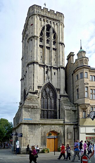
St Michael's Tower, Gloucester, stands at The Cross, where the four main streets of Gloucester meet. The Cross is also the highest point in the city. The Tower is on the corner of Eastgate and Southgate Streets and the entrance is in Southgate Street. It was built in 1465 on the site of the previous St Michael the Archangel. It is no longer used for religious ceremonies. It became a Grade II* listed building in 1952.

<span class="mw-page-title-main">Streets in Gibraltar</span>

Streets in the British Overseas Territory of Gibraltar are represented by road signs as in the United Kingdom. As of 2007, Gibraltar has a network of 29 kilometres (18 mi) of roads.

<span class="mw-page-title-main">Gloucester City Council</span>

Gloucester City Council is the local authority for Gloucester, a non-metropolitan district with city status in Gloucestershire, England.

<span class="mw-page-title-main">Basildon Town Centre</span> Commercial centre of Basildon

Basildon Town Centre is a planned town centre developed during the creation of the town of Basildon, Essex, in the 1950s. The architect Sir Basil Spence worked on its design.

<span class="mw-page-title-main">Eastgate Shopping Centre, Gloucester</span> Shopping mall in Gloucester, England

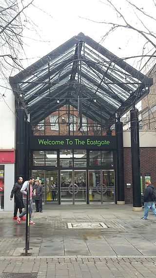
The Eastgate Shopping Centre is a two-story indoor shopping centre in Gloucester, England. It opened its portico entrance on 3 July 1973.

<span class="mw-page-title-main">Kings Square, Gloucester</span>

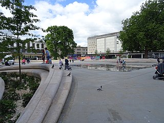
Kings Square is a market square in Gloucester, England connecting to Kings Walk Shopping Centre, Market Parade, The Oxbode and St Aldate Street.

<span class="mw-page-title-main">9 and 9A Southgate Street, Gloucester</span> Merchants house in Gloucester, United Kingdom

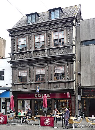
9 and 9A Southgate Street is a 17th-century Jacobean timber-framed merchant's house on Southgate Street, Gloucester. It has been a Grade I listed building since 23 January 1952. 9 Southgate Street is now occupied by Costa Coffee and 9A Southgate Street is occupied by The Tiger's Eye restaurant.

<span class="mw-page-title-main">Brunswick Square, Gloucester</span>

Brunswick Square is a 1.5-acre (0.61 ha) privately owned public garden with residential streets along three of its sides, in the English city of Gloucester. It is overlooked by the Christ Church to the east on Brunswick Road. The square is surrounded by terraced houses and flats with the Gloucester National Spiritualist Church on the north side and Gloucester House on the south side. There are nine grade listed buildings around the square. The square has been part of the Eastgate and St Michaels conservation area since 1968.

<span class="mw-page-title-main">Gloucester Transport Hub</span> Bus station in Gloucester, England

Gloucester Transport Hub is a bus station on Station Road in Gloucester, England.

Eastgate Street is one of the ancient streets in Gloucester, so named because its eastern end was originally the location of the east gate in the city's walls. The part beyond the gate as far as GL1 leisure Centre was part of Barton Street It runs from the crossroads of Northgate, Eastgate, Southgate and Westgate Streets in the West to Barton Street in the East.

References

  1. "Kings Walk Multi-Storey Car Park". Gloucester.gov. Archived from the original on 2 March 2017. Retrieved 5 March 2017.
  2. Verey, David; Brooks, Alan (1970). "The City Centre:3". Gloucestershire:The Vale and the Forest of Dean. p. 487.
  3. 1 2 3 "Planning Concept Statement -KINGS QUARTER" (PDF). Gloucester Partnership. Archived (PDF) from the original on 5 August 2016. Retrieved 5 March 2017.
  4. 1 2 "Gloucester, 1835-1985: Topography". British History. Archived from the original on 14 February 2017. Retrieved 5 March 2017.
  5. "Gloucester: Street names". British History. Archived from the original on 28 February 2017. Retrieved 5 March 2017.
  6. Jordan, Christine (2015). "5. Notable Gloucestrians". Secret Gloucester.
  7. Boobyer, Leigh (28 November 2018). "How these images of King's Walk are set to come one step closer to reality any day now". Gloucestershire Live. Archived from the original on 29 November 2018. Retrieved 22 July 2020.
  8. "Gloucester, 1835-1985: Topography". British History Online. Archived from the original on 14 February 2017. Retrieved 19 February 2017.
  9. "Brexit halts £25million Gloucester Kings Walk investment deal". 15 August 2016. Archived from the original on 6 March 2017. Retrieved 5 March 2017.
  10. "New owners announced for Kings Walk Shopping Centre". Gloucestershire Live. 10 July 2017. Archived from the original on 10 September 2017. Retrieved 10 September 2017.
  11. "The £12m plan that could change shopping in Gloucester forever - and why Eastgate Street might never look the same again". Gloucestershire Live. 21 March 2018. Archived from the original on 24 March 2018. Retrieved 24 March 2018.
  12. 1 2 "The King's Walk Bastion" (PDF). Gloucester History Festival. Archived from the original (PDF) on 6 March 2017. Retrieved 5 March 2017.
  13. "Gloucester Civic Trust - History" (PDF). Archived (PDF) from the original on 6 March 2017. Retrieved 5 March 2017.
  14. "Gloucester's hidden Roman history opened to the public". BBC News. 2 September 2016. Archived from the original on 20 March 2017. Retrieved 5 March 2017.