
Newport is a seaside city on Aquidneck Island in Rhode Island, United States. It is located in Narragansett Bay, approximately 33 miles (53 km) southeast of Providence, 20 miles (32 km) south of Fall River, Massachusetts, 74 miles (119 km) south of Boston, and 180 miles (290 km) northeast of New York City. It is known as a New England summer resort and is famous for its historic mansions and its rich sailing history. The city has a population of about 25,000 residents.

Jamestown is a town in Newport County, Rhode Island in the United States. The population was 5,559 at the 2020 census. Jamestown is situated almost entirely on Conanicut Island, the second largest island in Narragansett Bay. It also includes the uninhabited Dutch Island and Gould Island.

Aquidneck Island, officially known as Rhode Island, is an island in Narragansett Bay in the state of Rhode Island. The total land area is 37.8 sq mi (98 km2), which makes it the largest island in the bay. The 2020 United States Census reported its population as 60,109. The state of Rhode Island is named after the island; the United States Board on Geographic Names recognizes Rhode Island as the name for the island, although it is widely referred to as Aquidneck Island in the state and by the island's residents.

The Naval Undersea Warfare Center (NUWC) is the United States Navy's full-spectrum research, development, test and evaluation, engineering and fleet support center for submarines, autonomous underwater systems, and offensive and defensive weapons systems associated with undersea warfare. It is one of the corporate laboratories of the Naval Sea Systems Command. NUWC is headquartered in Newport, Rhode Island and has two major subordinate activities: Division Newport and Division Keyport in Keyport, Washington. NUWC also controls the Fox Island facility and Gould Island. It employs more than 4,400 civilian and military personnel, with budgets over $1 billion.

HMS Rose was a 20-gun Seaford-class post ship of the Royal Navy, built at Blaydes Yard in Hull, England in 1757 and in service until 1779. Her activities in suppressing smuggling in the colony of Rhode Island provoked the formation of what became the Continental Navy, precursor of the modern United States Navy. She was based at the North American station in the West Indies and then used in the American Revolutionary War. A replica was built in 1970, then modified to match HMS Surprise, and used in two films, Master and Commander: Far Side of the World and Pirates of the Caribbean: On Stranger Tides.

The Newport Harbor Light, also known as the Goat Island Light or Green Light, built in 1842, is located on north end of Goat Island, which is part of the city of Newport, Rhode Island, United States, in Narragansett Bay. The light was added to the National Register of Historic Places in 1988.

Dutch Island is an island lying west of Conanicut Island at an entrance to Narragansett Bay in Rhode Island, United States. It is part of the town of Jamestown, Rhode Island, and has a land area of 0.4156 km². It was uninhabited as of the United States Census, 2000. The island was fortified from the American Civil War through World War II and was known as Fort Greble from 1898 to 1947.

Gould Island lies east of Conanicut Island in Narragansett Bay in Rhode Island. It is a part of the town of Jamestown and has a land area of 55.3 acres (22.4 ha).

Hog Island is an American island in Narragansett Bay in Rhode Island. It lies at the entrance to the harbor of Bristol and is part of the town of Portsmouth. The 60 ft (18 m) tall Hog Island Shoal Lighthouse stands off the south end, warning ships of the dangerous shoals around the island. It has a land area of approximately 0.3 sq mi, making it the fifth-largest island in Narragansett Bay. It is home to a small summer vacation colony, with no regular year-round residents, and there are approximately 100 homes on it.

Beavertail State Park is a public recreation area encompassing 153 acres (62 ha) at the southern end of Conanicut Island in Narragansett Bay, Rhode Island. The state park's main attraction is the active Beavertail Lighthouse, the current tower of which dates from 1856. During World War II, the park area was part of Fort Burnside, one of several coastal fortifications designed to protect Narragansett Bay. The park's scenic shoreline offers hiking, picnicking, and saltwater fishing.

Whale Rock or Submarine Rock is the smallest island in Narragansett Bay in Rhode Island. It is located in the West Passage of the bay in Narragansett, Washington County, Rhode Island, west of the Beavertail area on Conanicut Island. The island received its names because it is shaped like a whale's back or a submarine's bow. It was responsible for numerous shipwrecks prior to the construction of a lighthouse. Whale Rock Light was built on the rock in 1882; it was destroyed by the 1938 New England hurricane, which also claimed the life of keeper Walter Eberle. Part of the lighthouse's foundation can still be seen.
Coasters Harbor Island is a 92-acre (370,000 m2) island in Narragansett Bay, Newport, Rhode Island. The island is home to the Naval War College (NWC), an education and research institution of the United States Navy that specializes in developing ideas for naval warfare and passing them along to officers of the Navy.
Rabbitt Island is a small island in Wickford Harbor, Narragansett Bay, Wickford, Rhode Island. Roger Williams received the island from Chief Canonicus' wife as a gift for a place to raise his goats. Richard Smith, who built Smith's Castle, later owned the island.
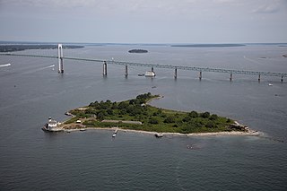
Rose Island is an 18.5-acre (7.5 ha) island in Narragansett Bay off Newport, Rhode Island, United States. It is allegedly named "Rose Island" because at low tide the island appears to be shaped like a rose. The Island is only accessible by boat. The island and its lighthouse are run by the private, non-profit Rose Island Lighthouse Foundation.
The Fort Hamilton Historic District is a historic district including all of Rose Island in Newport, Rhode Island. The district includes Rose Island Light and an early U.S. military fortification designed in part by Major Louis de Tousard. The fort was named after Alexander Hamilton, and was part of the first system of US fortifications.
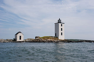
Dutch Island Light is a historic lighthouse on Dutch Island off Jamestown, Rhode Island.
Fort Wolcott was a fortification on the small Goat Island in Newport Harbor of Narragansett Bay less than 1 mile west of the city of Newport, Rhode Island. The attacks on HMS St John and HMS Liberty occurred near the fort.
Timeline of Newport, Rhode Island.

The Harbor Defenses of Narragansett Bay was a United States Army Coast Artillery Corps harbor defense command. It coordinated the coast defenses of Narragansett Bay and Rhode Island from 1895 to 1950, beginning with the Endicott program. These included both coast artillery forts and underwater minefields. The command originated circa 1895 as an Artillery District, was renamed Coast Defenses of Narragansett Bay in 1913, and again renamed Harbor Defenses of Narragansett Bay in 1925.
The 243rd Coast Artillery Regiment was a Coast Artillery Corps regiment in the Rhode Island National Guard. It garrisoned the Harbor Defenses of Narragansett Bay, Rhode Island 1924–1944.

 Fog horn on Goat Island
 Hyatt Hotel on Goat Island. Gurney's took over the property in 2016.
 Marina Bar and Grille is located in the only U.S. Navy building remaining on Goat Island
 Condos on Goat Island, built in 1978 and 1979
 Harbor Houses on Goat Island
 Harbor Houses on Goat Island
 Belle Mer
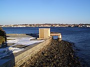
 Seawall on Goat Island in Newport, Rhode Island
 Fort George with colonial era Newport in the background


