Jamestown, Rhode Island

Last updated

Jamestown, Rhode Island
Jamestown Windmill.JPG
Jamestown Windmill, built in 1787
Jamestown RI lg.PNG
Location of Jamestown in Newport County, Rhode Island
Coordinates: 41°31′N71°22′W / 41.517°N 71.367°W / 41.517; -71.367
CountryUnited States
State Rhode Island
County Newport
Government
  TypeCouncil - Administrator form of government
  AdministratorJamie Hainsworth
  Town CouncilMichael G. White (D)
Mary E. Meagher (D)
Nancy E. Beye (I)
Randall White (D)
Erik Brine (D)
  ModeratorJohn A. Murphy (D)
Area
  Total35.3 sq mi (91.5 km2)
  Land9.7 sq mi (25.1 km2)
  Water25.6 sq mi (66.4 km2)
Elevation
[1]
62 ft (19 m)
Population
 (2020)
  Total5,559
  Density574/sq mi (221.5/km2)
Time zone UTC−5 (Eastern (EST))
  Summer (DST) UTC−4 (EDT)
ZIP code
02835
Area code 401
FIPS code 44-36820 [2]
GNIS feature ID1220061 [1]
Website Town website

Jamestown is a town in Newport County, Rhode Island in the United States. The population was 5,559 at the 2020 census. Jamestown is situated almost entirely on Conanicut Island, the second largest island in Narragansett Bay. It also includes the uninhabited Dutch Island and Gould Island.

Contents

Geography

The Newport Bridge connects Jamestown with Newport, a city on Aquidneck Island Claiborne Pell Newport Bridge.jpg
The Newport Bridge connects Jamestown with Newport, a city on Aquidneck Island

According to the United States Census Bureau, the town has an area of 35.3 square miles (91 km2), of which 9.7 square miles (25 km2) is land and 25.6 square miles (66 km2) is water. The total area is 72.55% water.

Rhode Island Route 138 is the only state highway in Jamestown, connecting the town and island to North Kingstown to the west (over the Jamestown Verrazzano Bridge) and Newport to the east (over the Claiborne Pell Newport Bridge).

History

In 1524, Italian navigator Giovanni da Verrazzano and his crew visited Narragansett Bay. [3] Dutch Island was used by fur traders c.1622, [4] and English colonists in 1638 made arrangements with the native Americans to use Conanicut Island for grazing sheep. [5]

The original Jamestown Bridge, which connected Jamestown with North Kingstown, Rhode Island from 1940 until its demolition in 2006 Old Jamestown Bridge.jpg
The original Jamestown Bridge, which connected Jamestown with North Kingstown, Rhode Island from 1940 until its demolition in 2006

Ferries were in operation between Conanicut Island and Newport by 1675. In 1678, Conanicut Island was incorporated as the town of Jamestown, [6] when there were about 150 residents. It was named for James, Duke of York, who became King James II in 1685. [7]

By 1710, many of Conanicut Island's current roads were in place. In 1728, the town of Jamestown built a windmill for grinding corn, [8] which used the sea breeze for power since there was no source of running water to turn a waterwheel.

American Revolution

Two hundred British and Hessian troops, commanded by James Wallace, landed at East Ferry on Conanicut Island on December 10, 1775. [9] [10] They then marched to West Ferry where they burned the ferry house. [10] As they returned to East Ferry, they destroyed many buildings, including 14 homes, which caused more than 200 of Conanicut Island's 556 residents to flee to the mainland.

In December 1776, a British fleet arrived in Narragansett Bay and occupied Newport. [11] The British took over the colonial militia batteries at Fort Dumpling (now part of Fort Wetherill) and the Conanicut Battery at Beavertail, just south of Fort Getty at the end of Battery Lane. They left Narragansett Bay in October 1779; as they departed, they destroyed the fortifications which they had occupied and burned down the Beavertail Lighthouse. [11]

18th and 19th centuries

Beavertail Lighthouse was back in operation by 1784, and Jamestown rebuilt the Jamestown Windmill and Quaker Meetinghouse in 1787 that had been destroyed during the occupation.

In 1800, Fort Dumpling was established on the site of previous fortifications overlooking East Passage. A tall stone tower atop the highest cliff could hold eight guns.

The town of Jamestown commissioned a steam-powered ferryboat in 1872 and initiated service between Jamestown and Newport in May 1873. The availability of reliable and comfortable ferry service to and from Newport had a significant impact on agricultural Conanicut Island, and Jamestown became a destination for both day trips and summer vacations.

The 1880s and 1890s saw a construction boom, with hotels, private summer homes, and municipal buildings going up. The island's population tripled between 1870 and 1900.

20th century to the present

There was a burst of military fortification activity from 1890 to the end of World War I. The Spanish–American War was a catalyst, beginning in 1898, and work began on Dutch Island's Fort Greble. The War Department bought 31 acres (130,000 m2) for Fort Getty, and fortifications were quickly erected. Summer homes were condemned near Fort Dumpling to establish Fort Wetherill. More land was acquired at Prospect Hill near the Conanicut Battery site for an observation and fire control station, and the government established a torpedo station and test facility on Gould Island. Then, at the end of the First World War, the Conanicut Island fortifications fell into disuse. World War II brought establishment or reactivation of military bases around Narragansett Bay, including Forts Getty, Burnside, and Wetherill on Conanicut Island, Fort Greble on Dutch Island, a torpedo factory on Goat Island, and a torpedo station on Gould Island. [5]

The Jamestown-Verrazano Bridge, constructed in 1992, connects Jamestown with mainland Rhode Island Jamestown Verrazano Bridge 2007.jpg
The Jamestown-Verrazano Bridge, constructed in 1992, connects Jamestown with mainland Rhode Island

Jamestown was a bustling summer destination in the early 1900s, and it had nine hotels in 1903. The golden age of large resort hotels was brief, however, in Jamestown and elsewhere, and patronage rapidly declined in the 1920s. The Thorndike Hotel was demolished in 1938. The Gardner House was one of the larger hotels, but it was taken down in 1941 after being idle for several years, and a USO building was built on its site. After the war, the town purchased the building and it is now known as the community center. It was extensively landscaped and remodeled in 2002. The Bay View Hotel closed in the 1960s, the last of the very large hotels. The building was demolished in 1985, and the Bay View Condominiums opened for occupancy four years later. The building exterior was designed to resemble the hotel. The Bay Voyage Hotel is the only survivor of the many hotels that once lined Jamestown's eastern harbor, now operating as a time share resort. [5]

In 1938, a major hurricane caused much property damage and the loss of more than 300 lives in the Narragansett Bay region. It swept away much of the sand from the Mackerel Cove beach, destroyed its popular beach pavilion, and destroyed the West Ferry docks—which actually speeded approvals for a bridge to Saunderstown. [12] The first Jamestown Bridge opened in the summer of 1940, replacing West Ferry service with a continuously available link to the west.

Demolition of the original Jamestown Bridge in 2006 Jamestown Bridge demolition2.jpg
Demolition of the original Jamestown Bridge in 2006

In 1969, the Claiborne Pell Newport Bridge was completed, establishing Route 138 as a continuous highway from South County to Newport. With its completion, traditional ferry service was eliminated. The bridge is pictured on the 2001 Rhode Island state quarter. [13] In 1992, the Jamestown-Verrazano Bridge replaced the narrow steel bridge erected in 1940. It was accompanied by construction of a new western-end access road and a cross-Conanicut Island highway.

Demographics

Historical population
CensusPop.Note
1790 507
1800 501−1.2%
1810 5040.6%
1820 448−11.1%
1830 415−7.4%
1840 365−12.0%
1850 358−1.9%
1860 40011.7%
1870 378−5.5%
1880 45921.4%
1890 70754.0%
1900 1,09154.3%
1910 1,1757.7%
1920 1,63339.0%
1930 1,599−2.1%
1940 1,7449.1%
1950 2,06818.6%
1960 2,2679.6%
1970 2,91128.4%
1980 4,04038.8%
1990 4,99923.7%
2000 5,62212.5%
2010 5,405−3.9%
2020 5,5592.8%
U.S. Decennial Census [14] [15]

According to the most recent Jamestown Rhode Island demographics data available from the United States Census Bureau released in the American Community Survey in December 2019, [16] Jamestown has a population of 5,496. There were 2,965 housing units of which 16.3% were rentals (including homes, apartments, etc.), for a housing density of 313.8 per square mile. Housing units decreased by −1.1% from 2010 to 2019.

The median home price in Jamestown was $641,800, which is higher than most other towns in the region. Homes worth between $1,500,000 to $2,000,000 accounted for 17% of the homes in Jamestown and 17% were worth $2,000,000 or more. The median real estate taxes paid amounted to $4,988.

Private preschool enrollment on Jamestown was 36% of the total school age population. Of the residents, 97% were high school graduates or better and 65% had a bachelor’s degree or higher. Those with a professional degree (e.g., law or medicine) made up 5.7% of the town population.

The median household income in Jamestown was $108,737. Over 16% or the residents were self-employed and 71% were employed full time. Households with retirement income accounted for 26.6% of the residents. Single earner households made of 33% of the household in Jamestown.

Jamestown Public Schools encompasses two buildings: Melrose School for elementary students and Lawn School for middle school students. For high school, public school students matriculate to either North Kingstown High School or Narragansett High School. [17]

Portions of several movies have been filmed in and around Jamestown, including Wind ; Me, Myself & Irene ; American General (PBS); Evening ; Dan in Real Life ; Moonrise Kingdom ; and Irrational Man . The comic strip Wallace the Brave was created and drawn by Jamestown resident Will Henry and set in the fictional Rhode Island town of Snug Harbor, which is loosely based on Jamestown. [18]

Notable people

National Historic Places and notable sites in Jamestown

Dutch Island Light Dutch Island.jpg
Dutch Island Light

Related Research Articles

<span class="mw-page-title-main">Aquidneck Island</span> Island in Rhode Island, United States

Aquidneck Island, officially known as Rhode Island, is an island in Narragansett Bay in the state of Rhode Island. The total land area is 37.8 sq mi (98 km2), which makes it the largest island in the bay. The 2020 United States Census reported its population as 60,109. The state of Rhode Island is named after the island; the United States Board on Geographic Names recognizes Rhode Island as the name for the island, although it is widely referred to as Aquidneck Island in the state and by the island's residents.

<span class="mw-page-title-main">Conanicut Island</span> Island in Rhode Island, US

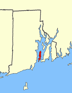
Conanicut Island is an island in Narragansett Bay in the American state of Rhode Island. The second-largest in the Bay, it is connected on the east to Newport on Aquidneck Island by the Claiborne Pell Bridge, commonly known as the Newport Bridge, and on the west to North Kingstown on the mainland via the Jamestown-Verrazano Bridge. The town of Jamestown comprises the entire island. The U.S. Census Bureau reported a land area of 24.46 km2 (9.44 sq mi) and a population of 5,622 in 2000. A tombolo connects the southern part of Conanicut to an extension of the island to the southwest.

<span class="mw-page-title-main">Claiborne Pell Newport Bridge</span> Bridge in Between Jamestown and Newport, Rhode Island

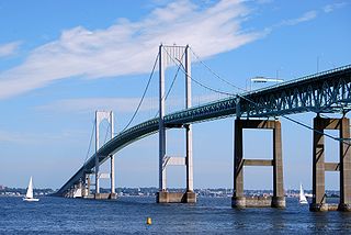
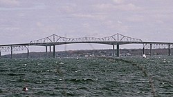
The Claiborne Pell Bridge, commonly known as the Newport Bridge, is a suspension bridge operated by the Rhode Island Turnpike and Bridge Authority that spans the East Passage of the Narragansett Bay in Rhode Island. The bridge, part of RI 138, connects the city of Newport on Aquidneck Island and the Town of Jamestown on Conanicut Island, and is named for longtime Rhode Island U.S. senator Claiborne Pell who lived in Newport. The Pell Bridge is in turn connected to the mainland by the Jamestown Verrazzano Bridge.

<span class="mw-page-title-main">Jamestown Bridge</span> Now-demolished bridge in Rhode Island

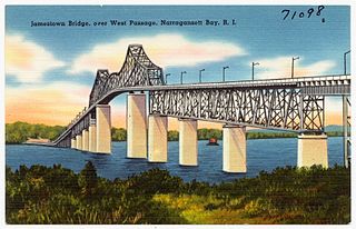
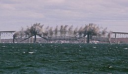
The Jamestown Bridge was a cantilever truss bridge that connected Conanicut Island to mainland North Kingstown, Rhode Island, spanning the West passage of Narragansett Bay. The bridge first opened to traffic in 1940, replacing ferry service as the primary connection for the town of Jamestown, situated on Conanicut Island. It was constructed for just over $3 million 1940 USD, which was paid for by tolls until June 28, 1969. With a total length of 6,892 feet, the Jamestown Bridge was the third longest in Rhode Island at the time of its destruction, ranking behind its replacement, the adjacent 7,350-foot Jamestown Verrazzano Bridge, and the 11,248-foot Claiborne Pell Newport Bridge connecting Conanicut Island to Aquidneck Island and Newport. The Jamestown Bridge was closed to vehicular traffic on October 8, 1992, and its main span was destroyed through a controlled demolition on April 18, 2006.

<span class="mw-page-title-main">Dutch Island (Rhode Island)</span>

Dutch Island is an island lying west of Conanicut Island at an entrance to Narragansett Bay in Rhode Island, United States. It is part of the town of Jamestown, Rhode Island, and has a land area of 0.4156 km². It was uninhabited as of the United States Census, 2000. The island was fortified from the American Civil War through World War II and was known as Fort Greble from 1898 to 1947.

<span class="mw-page-title-main">Gould Island (Rhode Island)</span> Island in Rhode Island

Gould Island lies east of Conanicut Island in Narragansett Bay in Rhode Island. It is a part of the town of Jamestown and has a land area of 55.3 acres (22.4 ha).

<span class="mw-page-title-main">Beavertail State Park</span> State park in Rhode Island, United States

Beavertail State Park is a public recreation area encompassing 153 acres (62 ha) at the southern end of Conanicut Island in Narragansett Bay, Rhode Island. The state park's main attraction is the active Beavertail Lighthouse, the current tower of which dates from 1856. During World War II, the park area was part of Fort Burnside, one of several coastal fortifications designed to protect Narragansett Bay. The park's scenic shoreline offers hiking, picnicking, and saltwater fishing.

<span class="mw-page-title-main">Beavertail Lighthouse</span> United States historic place

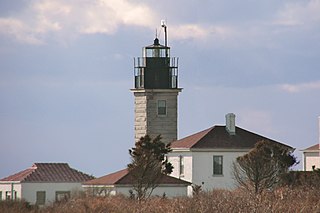
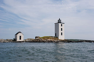
Beavertail Lighthouse was built in 1856 and is the premier lighthouse in Rhode Island, marking the entrance to Narragansett Bay. The 64-foot (20 m) lighthouse lies on the southernmost point of Conanicut Island in the town of Jamestown, Rhode Island in Beavertail State Park, on a site where beacons have stood since the early 18th century. The light provides navigation for boats and ships entering Narragansett Bay in the East Passage between Conanicut Island and Newport, Rhode Island on Aquidneck Island. Other lighthouses are visible from Beavertail Lighthouse, such as Castle Hill Lighthouse, Point Judith Light, and Rose Island Light.

<span class="mw-page-title-main">Whale Rock</span>

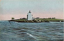
Whale Rock or Submarine Rock is the smallest island in Narragansett Bay in Rhode Island. It is located in the West Passage of the bay in Narragansett, Washington County, Rhode Island, west of the Beavertail area on Conanicut Island. The island received its names because it is shaped like a whale's back or a submarine's bow. It was responsible for numerous shipwrecks prior to the construction of a lighthouse. Whale Rock Light was built on the rock in 1882; it was destroyed by the 1938 New England hurricane, which also claimed the life of keeper Walter Eberle. Part of the lighthouse's foundation can still be seen.

<span class="mw-page-title-main">Rose Island (Rhode Island)</span> Island in Narragansett Bay, Rhode Island, USA

Rose Island is an 18.5-acre (7.5 ha) island in Narragansett Bay off Newport, Rhode Island, United States. It is allegedly named "Rose Island" because at low tide the island appears to be shaped like a rose. The Island is only accessible by boat. The island and its lighthouse are run by the private, non-profit Rose Island Lighthouse Foundation.

<span class="mw-page-title-main">Fort Wetherill</span> Historic site in Rhode Island, United States

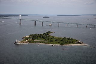
Fort Wetherill is a former coast artillery fort that occupies the southern portion of the eastern tip of Conanicut Island in Jamestown, Rhode Island. It sits atop high granite cliffs, overlooking the entrance to Narragansett Bay. Fort Dumpling from the American Revolutionary War occupied the site until it was built over by Fort Wetherill. Wetherill was deactivated and turned over to the State of Rhode Island after World War II and is now operated as Fort Wetherill State Park, a 51-acre (210,000 m2) reservation managed by the Rhode Island Department of Environmental Management.

<span class="mw-page-title-main">Conanicut Island Light</span> United States historic place

Conanicut Island Light, built in 1886, is an inactive lighthouse in Jamestown, Rhode Island.

The Conanicut Battery is a colonial and 20th century military battery in Jamestown, Rhode Island, west of Beaver Tail Road. The site offers a commanding view of the West Passage of Narragansett Bay.

<span class="mw-page-title-main">Dutch Island Light</span> Lighthouse

Dutch Island Light is a historic lighthouse on Dutch Island off Jamestown, Rhode Island.

<span class="mw-page-title-main">Fort Getty</span>

Fort Getty is a town park in Jamestown, Rhode Island, on Conanicut Island in Narragansett Bay. From 1900 through World War II it was a military fort. The Town of Jamestown later received the property and opened it as a park, primarily a campground.

Fort Wolcott was a fortification on the small Goat Island in Newport Harbor of Narragansett Bay less than 1 mile west of the city of Newport, Rhode Island. The attacks on HMS St John and HMS Liberty occurred near the fort.

<span class="mw-page-title-main">Fort Wetherill State Park</span>

Fort Wetherill State Park is a public recreation area occupying 61.5 acres (24.9 ha) at the southeastern tip of Conanicut Island in the town of Jamestown, Rhode Island. The state park sits on the East Passage of Narragansett Bay opposite Fort Adams State Park. From 1901 through World War II, Fort Wetherill and Fort Adams were part of a string of coastal defenses designed to protect the bay's entrance points. The Fort Wetherill battery and training camp were acquired by the State of Rhode Island from the United States in 1972. The park is used for sightseeing, scuba diving, picnicking, boating, fishing, and hiking. As of 2020, the fort itself is almost completely covered in graffiti.

<span class="mw-page-title-main">Charles L. Bevins</span> American architect

Charles Lovatt Bevins (1844–1925) was an American architect from Jamestown, Rhode Island.

<span class="mw-page-title-main">Harbor Defenses of Narragansett Bay</span> Military unit

The Harbor Defenses of Narragansett Bay was a United States Army Coast Artillery Corps harbor defense command. It coordinated the coast defenses of Narragansett Bay and Rhode Island from 1895 to 1950, beginning with the Endicott program. These included both coast artillery forts and underwater minefields. The command originated circa 1895 as an Artillery District, was renamed Coast Defenses of Narragansett Bay in 1913, and again renamed Harbor Defenses of Narragansett Bay in 1925.

The 243rd Coast Artillery Regiment was a Coast Artillery Corps regiment in the Rhode Island National Guard. It garrisoned the Harbor Defenses of Narragansett Bay, Rhode Island 1924–1944.

References

  1. 1 2 U.S. Geological Survey Geographic Names Information System: Jamestown, Rhode Island
  2. "U.S. Census website". United States Census Bureau . Retrieved January 31, 2008.
  3. Ronda, James P. (August 26, 2014). "Black Gowns and Massachusetts Men: Indian-White Relations in New England to 1701". In Weeks, Philip (ed.). "They Made Us Many Promises": The American Indian Experience 1524 to the Present. Harlan Davidson (Wiley). pp. 3–4. ISBN   978-1-118-82282-1.
  4. Parsons, Usher (February 1863). "Indian Relics Recently Found in Charlestown, R. I. with Brief Notices of the Nyantic Tribe of Indians". The Historical Magazine. 7 (2): 42. The Dutch soon opened trading stations; one at Quotenis, or Dutch Island as it is now called … Hither were brought furs by the Indians to exchange for Dutch goods, insomuch that when in 1622 or 3 the Pilgrims of Plymouth sent to this place a small vessel laden with beads and knives, they found the Indians abundantly supplied already with these …
  5. 1 2 3 Buttrick, James C., Images of America, Jamestown (2003) ISBN   0738511927
  6. Brinley, Francis (April 1882). "Conanicut Island". The Newport Historical Magazine. 2 (4): 193. In 1678, Mr. Caleb Carr and Mr. Francis Brinley, on behalf of themselves and the proprietors, for Quononoqutt Island (the Indian name for Conanicut Island), petitioned to the General Assembly for an act of Incorporation, which was then granted (Nov. 4, 1678) …
  7. Gannett, Henry (1905). The Origin of Certain Place Names in the United States. Govt. Print. Off. pp.  168.
  8. Stevens, Maud Lyman (1916). The Jamestown Windmill. Newport, Rhode Island: R. Ward. p. 7. OCLC   1047470243. … our first positive record [of a windmill] appears in 1728. In July of that year the proprietors and freemen at a quarterly meeting voted the erection of a windmill.
  9. Hellmann, Paul T. (February 14, 2006). Historical Gazetteer of the United States. Routledge. p. 959. ISBN   978-1-135-94859-7.
  10. 1 2 Force, Peter, ed. (1837). "Conanicut (Rhode Island) Plundered". American Archives. 4th series. Vol. 4. Washington, DC: M. St. Clair Clarke and Peter Force. p. 230.
  11. 1 2 Neimeyer, Charles P. (2010). "The British Occupation of Newport Rhode Island 1776–1779". Army History (74): 30–45. ISSN   1546-5330. JSTOR   26296027 .
  12. Lippencott, Bertram, Jamestown Sampler (1980)
  13. "Rhode Island State Quarter | U.S. Mint".
  14. "Census of Population and Housing". United States Census Bureau . Retrieved June 4, 2016.
  15. Snow, Edwin M. (1867). Report upon the Census of Rhode Island 1865. Providence, RI: Providence Press Company.
  16. "Jamestown Rhode Island Demographics data population census".
  17. Gibbs, Ryan (September 10, 2015). "Back to school: 491 children settle in class". The Jamestown Press. Retrieved September 4, 2016.
  18. Hill, John. "R.I. comics creator draws on childhood memories". providencejournal.com. Retrieved April 20, 2019.
  19. Shane, Ken (February 19, 2015). "Former Vanity 6 singer inducted into RI Music Hall of Fame". The Jamestown Press. Archived from the original on June 27, 2018. Retrieved April 23, 2016.
  20. "John Scott Biddle, 83". The Jamestown Press. October 9, 2008. Retrieved July 15, 2017.
  21. "M'Namee Retired; In Navy 40 Years" . The New York Times . New York City. May 10, 1934. p. 10. Retrieved November 10, 2010.
  22. "Mecray honored for yacht preservation efforts". The Jamestown Press. October 25, 2007. Retrieved June 2, 2009.
  23. Gibbs, Ryan (June 29, 2017). "Romash moves from politics to pastry". The Jamestown Press. Retrieved June 29, 2017.
  24. "CRMC Approves Controversial Marina Expansion".

Further reading