Glocester, Rhode Island

Last updated

Glocester, Rhode Island
Providence County Rhode Island incorporated and unincorporated areas Glocester highlighted.svg
Location in Providence County and the state of Rhode Island.
Coordinates: 41°53′27″N71°41′26″W / 41.89083°N 71.69056°W / 41.89083; -71.69056
Country United States
State Rhode Island
County Providence
IncorporatedFebruary 20, 1731
Government
  Type Town meeting
  Town CouncilJulian Forgue (R)
Walter M.O. Steere, III (R)
Stephen Arnold (R)
William Worthy (R)
William E. Reichart (I)
  Town ModeratorKevin P. Walsh (R)
  Town ClerkJean M. Fecteau (R)
Area
  Total56.8 sq mi (147.2 km2)
  Land54.8 sq mi (142.0 km2)
  Water2.0 sq mi (5.2 km2)
Elevation
[1]
597 ft (182 m)
Population
 (2020)
  Total9,974
  Density182/sq mi (70.2/km2)
Time zone UTC−5 (Eastern (EST))
  Summer (DST) UTC−4 (EDT)
ZIP Codes
02814 (Chepachet), 02829 (Harmony), 02857 (North Scituate)
Area code 401
FIPS code 44-30340 [2]
GNIS feature ID1220070 [1]
Website Town of Glocester

Glocester is a town in Providence County, Rhode Island, United States. The population was 9,974 as of the 2020 census. The villages of Chepachet and Harmony are in Glocester. Putnam Pike (U.S. Route 44) runs west through the town center of Glocester into Putnam, Connecticut.

Contents

History

Glocester was originally named Gloucester for Henry Stuart, Duke of Gloucester. [3] The Town of Gloucester was part of Providence until 1731 when it became an independent town. [4] North Glocester was incorporated as the separate town of Burrillville in 1806. At the same time the residents of Gloucester voted to change the spelling of the town to Glocester to differentiate it from Gloucester, Massachusetts. Glocester is an ancient variant spelling of Gloucester.

During the American Revolution, Loyalists from Newport were exiled in Glocester to Stephen Keach's farm, including Thomas Vernon, a Tory from Newport, who described Glocester residents in 1776 as:

inclined much to talk of liberty...It is amazing what false and erroneous opinions and ideas these people have entertained...The religion of the people of this town consists entirely of New Light Baptists. The custom of Dipping is much in vogue in this and the neighboring towns. [5]

Samuel Willard (physician) made rounds on smallpox victims in North Glocester during the late 18th century. [6]

The Dorr Rebellion began in Glocester in 1841.

Since 1927 the Ancient and Horribles Parade has been an annual Fourth of July tradition in Chepachet, where residents create traditional and satirical political floats.

See also "Foster, Rhode Island: History" for further information.

Geography

According to the United States Census Bureau, the town has a total area of 56.8 square miles (147 km2), of which 54.8 square miles (142 km2) is land and 2.0 square miles (5.2 km2) (3.55%) is water. Some bodies of water in Glocester include, Waterman Reservoir.

Demographics

Historical population
CensusPop.Note
1790 4,025
1800 4,009−0.4%
1810 2,310−42.4%
1820 2,5048.4%
1830 2,5210.7%
1840 2,304−8.6%
1850 2,87224.7%
1860 2,427−15.5%
1870 2,385−1.7%
1880 2,250−5.7%
1890 2,095−6.9%
1900 1,402−33.1%
1910 1,4040.1%
1920 1,389−1.1%
1930 1,69321.9%
1940 2,09924.0%
1950 2,68227.8%
1960 3,39726.7%
1970 5,16051.9%
1980 7,55046.3%
1990 9,22722.2%
2000 9,9487.8%
2010 9,746−2.0%
2020 9,9742.3%
U.S. Decennial Census [7] [8]

As of the census [2] of 2000, there were 9,948 people, 3,559 households, and 2,818 families residing in the town. The population density was 181.5 inhabitants per square mile (70.1/km2). There were 3,786 housing units at an average density of 69.1 per square mile (26.7/km2). The racial makeup of the town was 98.48% White, 0.34% African American, 0.15% Native American, 0.24% Asian, 0.10% from other races, and 0.68% from two or more races. Hispanic or Latino of any race were 0.65% of the population.

There were 3,559 households, out of which 38.0% had children under the age of 18 living with them, 66.4% were married couples living together, 8.6% had a female householder with no husband present, and 20.8% were non-families. 15.8% of all households were made up of individuals, and 6.0% had someone living alone who was 65 years of age or older. The average household size was 2.80 and the average family size was 3.14.

In the town, the population was spread out, with 26.8% under the age of 18, 6.4% from 18 to 24, 31.6% from 25 to 44, 26.1% from 45 to 64, and 9.2% who were 65 years of age or older. The median age was 38 years. For every 100 females, there were 100.0 males. For every 100 females age 18 and over, there were 95.6 males.

The median income for a household in the town was $57,537, and the median income for a family was $62,679. Males had a median income of $39,112 versus $29,071 for females. The per capita income for the town was $22,914. About 3.4% of families and 4.4% of the population were below the poverty line, including 6.4% of those under age 18 and 1.9% of those age 65 or over.

Education

Glocester is the home to both West Glocester Elementary School in West Glocester and the Fogarty Memorial School in Harmony. Students of both would attend both Ponaganset Middle School and Ponaganset High School for secondary education.

Notable people

Harmony Chapel Cemetery on U.S. Route 44 around the start of the 20th century Harmony Chapel.JPG
Harmony Chapel Cemetery on U.S. Route 44 around the start of the 20th century

National Historic Sites in Glocester

See also

Related Research Articles

<span class="mw-page-title-main">Providence County, Rhode Island</span> County in Rhode Island, United States

Providence County is the most populous county in the U.S. state of Rhode Island. As of the 2020 census, the county's population was 660,741, or 60.2% of the state's population. Providence County contains the city of Providence, the state capital of Rhode Island and the county's most populous city, with an estimated 190,934 residents in 2020. Providence County is included in the Providence-Warwick, RI-MA Metropolitan Statistical Area, which in turn constitutes a portion of the greater Boston-Worcester-Providence, MA-RI-NH-CT Combined Statistical Area. As of 2010, the center of population in Rhode Island is located in Providence County, in the city of Cranston.

<span class="mw-page-title-main">Newport County, Rhode Island</span> County in Rhode Island, United States

Newport County is one of five counties located in the U.S. state of Rhode Island. As of the 2020 census, the population was 85,643. It is also one of the seven regions of Rhode Island. The county was created in 1703. Like all of the counties in Rhode Island, Newport County no longer has any governmental functions. All of those functions in Rhode Island are now carried out either by the state government, or by the cities and towns of Rhode Island. Newport County is included in the Providence-Warwick, RI-MA Metropolitan Statistical Area, which is in turn constitutes a portion of the greater Boston-Worcester-Providence, MA-RI-NH-CT Combined Statistical Area.

<span class="mw-page-title-main">Kent County, Rhode Island</span> County in Rhode Island, United States

Kent County is a county located in the U.S. state of Rhode Island. As of the 2020 census, the population was 170,363, making it the second-most populous county in Rhode Island. The county was formed in 1750 from the southern third of Providence County. It was named after the county of Kent, England. Kent County, like other counties in Rhode Island, no longer has governmental functions. Its seat is East Greenwich. Kent County is included in the Providence-Warwick, RI-MA Metropolitan Statistical Area, which in turn constitutes a portion of the greater Boston-Worcester-Providence, MA-RI-NH-CT Combined Statistical Area.

<span class="mw-page-title-main">Bristol County, Rhode Island</span> County in Rhode Island, United States

Bristol County is a county located in the U.S. state of Rhode Island. As of the 2020 census, the population was 50,793, making it the least populous county in Rhode Island. In terms of land area, it is the third-smallest county in the United States, at only 25 square miles (65 km2). The county was created in 1747 when it was separated from Bristol County, Massachusetts. Bristol County is included in the Providence-Warwick, RI-MA Metropolitan Statistical Area, which in turn constitutes a portion of the greater Boston-Worcester-Providence, MA-RI-NH-CT Combined Statistical Area.

<span class="mw-page-title-main">Warren, Rhode Island</span> Town in Rhode Island, United States

Warren is a town in Bristol County, Rhode Island, United States. The population was 11,147 at the 2020 census.

<span class="mw-page-title-main">West Greenwich, Rhode Island</span> Town in Rhode Island, United States

West Greenwich is a town in Kent County, Rhode Island, United States. The population was 6,528 at the 2020 census. West Greenwich was named for the historic town of Greenwich, Kent, England. It was separated from East Greenwich in 1741. Students go to Exeter-West Greenwich Regional School in West Greenwich.

<span class="mw-page-title-main">Portsmouth, Rhode Island</span> Town in Rhode Island, United States

Portsmouth is a town in Newport County, Rhode Island, United States. The population was 17,871 at the 2020 U.S. census. Portsmouth is the second-oldest municipality in Rhode Island, after Providence; it was one of the four colonies which merged to form the Colony of Rhode Island and Providence Plantations, the others being Providence, Newport, and Warwick.

<span class="mw-page-title-main">Burrillville, Rhode Island</span> Town in Rhode Island, United States

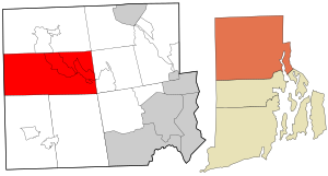
Burrillville is a town in Providence County, Rhode Island, United States. The population was 16,158 at the 2020 census.

<span class="mw-page-title-main">Foster, Rhode Island</span> Town in Rhode Island, United States

Foster is a town in Providence County, Rhode Island, in the United States. The population was 4,469 at the 2020 census.

<span class="mw-page-title-main">Harrisville, Rhode Island</span> Census-designated place in Rhode Island, United States

Harrisville is a census-designated place (CDP) and village in the town of Burrillville in Providence County, Rhode Island, United States. The population was 1,605 at the 2010 census. Much of the community composes a historic district listed on the National Register of Historic Places. The village was named after nineteenth century manufacturer Andrew Harris. Previously, the village was named Rhodesville, after Captain William Rhodes, an eighteenth century privateer.

<span class="mw-page-title-main">Lincoln, Rhode Island</span> Town in Rhode Island, United States

Lincoln is a town in Providence County, Rhode Island, United States. The population was 22,529 at the 2020 census. Lincoln is located in northeastern Rhode Island, north of Providence. Lincoln is part of the Providence metropolitan statistical area and the Greater Boston combined statistical area.

<span class="mw-page-title-main">North Smithfield, Rhode Island</span> Town in Rhode Island, United States

North Smithfield is a town in Providence County, Rhode Island, United States, settled as a farming community in 1666 and incorporated into its present form in 1871. North Smithfield includes the historic villages of Forestdale, Primrose, Waterford, Branch Village, Union Village, Park Square, and Slatersville. The population was 12,588 at the 2020 census.

<span class="mw-page-title-main">Scituate, Rhode Island</span> Town in Rhode Island, United States

Scituate is a town in Providence County, Rhode Island, United States. The population was 10,384 at the 2020 census.

<span class="mw-page-title-main">Valley Falls, Rhode Island</span> Village and census-designated place in Rhode Island, US

Valley Falls is a village and census-designated place (CDP) in the town of Cumberland, Providence County, Rhode Island, United States. The population was 12,094 at the 2020 census.

<span class="mw-page-title-main">Exeter, Rhode Island</span> Town in Rhode Island, United States

Exeter is a town in Washington County, Rhode Island, United States. Exeter extends east from the Connecticut border to the town of North Kingstown. It is bordered to the north by West Greenwich and East Greenwich, and to the south by Hopkinton, Richmond, and South Kingstown. Exeter's postal code is 02822, although small parts of the town have the mailing address West Kingston (02892) or Saunderstown (02874). The population was 6,460 at the 2020 census.

<span class="mw-page-title-main">Hope Valley, Rhode Island</span> Census-designated place in Rhode Island, United States

Hope Valley is a village and census-designated place (CDP) in the town of Hopkinton, Rhode Island, United States. The population of the CDP was 1,612 at the 2010 census. Hope Valley is the largest village in Hopkinton, and the town's principal commercial center. While the village of Hope Valley is located in Hopkinton, its zip code, 02832, extends into the neighboring town of Richmond.

<span class="mw-page-title-main">Hopkinton, Rhode Island</span> Place in Rhode Island, United States

Hopkinton is a town in Washington County, Rhode Island. The population was 8,398 at the 2020 census.

<span class="mw-page-title-main">North Providence, Rhode Island</span> Town in Rhode Island, United States

North Providence is a town in Providence County, Rhode Island, United States. The population was 34,114 at the 2020 census.

<span class="mw-page-title-main">Harmony, Rhode Island</span> Census-designated place in Rhode Island, United States

Harmony is a village and census-designated place in Providence County, Rhode Island, in the town of Glocester, located on U.S. Route 44. As of the 2010 census, it had a population of 985.

<span class="mw-page-title-main">Chepachet, Rhode Island</span> United States historic place

Chepachet is a village and census-designated place (CDP) in the town of Glocester in the northwestern part of the U.S. state of Rhode Island. It is centered at the intersection of U.S. Route 44 and Rhode Island Route 102. Chepachet's ZIP code is 02814. As of the 2010 census, the CDP had a population of 1,675.

References

  1. 1 2 U.S. Geological Survey Geographic Names Information System: Glocester, Rhode Island
  2. 1 2 "U.S. Census website". United States Census Bureau . Retrieved January 31, 2008.
  3. Dictionary of world place names derived from British names, by Adrian Room, Edition: illustrated, Published by Taylor & Francis, 1989, pg. 68 ISBN   0-415-02811-6, ISBN   978-0-415-02811-0
  4. Elizabeth A. Perry, A brief history of the town of Glocester, Rhode Island (Providence Press Co., Printers, 1886)
  5. Diary of Thomas Vernon pgs. 9, 26
  6. Backofen, Walter A (2001). Elias Frost, M.D., and his strategy for being remembered. p. 6. OCLC: 58438763.
  7. "Census of Population and Housing". Census.gov. Retrieved June 4, 2016.
  8. Snow, Edwin M. (1867). Report upon the Census of Rhode Island 1865. Providence, RI: Providence Press Company.