South Kingstown, Rhode Island

Last updated

South Kingstown, Rhode Island
Town of South Kingstown
SK town hall.jpg
South Kingstown Town Hall
South Kingstown, RI Seal.png
Nickname: 
"SK"
S Kingstown RI lg.PNG
Location of South Kingstown in Washington County, Rhode Island
Coordinates: 41°26′51″N71°31′38″W / 41.44750°N 71.52722°W / 41.44750; -71.52722
Country Flag of the United States.svg  United States
State Flag of Rhode Island.svg  Rhode Island
Region New England
County Washington
Historic colonies Colony of Rhode Island and Providence Plantations
Settled1641
Split from Kings Towne1723
Incorporated1723 [1]
Government
  Type Council–manager government
  Town CouncilRory McEntee (President) (D) [2]
Michael Marran (Vice President) (D)
Patricia Alley (D)
Deborah Bergner (I)
C. Greg Sweet (R)
  Town ManagerJames Manni [3]
   R.I. Senators
   R.I. House delegation
Area
  Total79.8 sq mi (206.6 km2)
  Land57.1 sq mi (147.9 km2)
  Water22.7 sq mi (58.7 km2)
Elevation
98 ft (30 m)
Population
 (2020)
  Total31,913
  Density559/sq mi (215.9/km2)
Time zone UTC-5 (Eastern (EST))
  Summer (DST) UTC-4 (EDT)
ZIP codes
02879 (Wakefield), 02881 (Kingston), 02883 (Peace Dale), 02892 (West Kingston)
Area code 401
FIPS code 44-67460 [4]
GNIS feature ID1220090 [5]
Website http://www.southkingstownri.com

South Kingstown is a town in, and the county seat of, Washington County, Rhode Island, United States. The population was 31,931 at the 2020 census. South Kingstown is the second largest town in Rhode Island by total geographic area, behind New Shoreham, and the third largest town in Rhode Island by geographic land area, behind Exeter and Coventry.

Contents

History

The Narragansett Indians were known to occupy a winter camp in the Great Swamp, within present day South Kingstown. [6]

In March 1638, Rhode Island founder Roger Williams signed an agreement with two Sachems of the Narragansett Tribe, Canonicus and Miantonomoh, establishing the boundaries between the Narragansett Tribe and the Colony of Rhode Island, as well as to purchase Aquidneck Island. [7] [8] The agreement was signed at Pettaquamscutt Rock, which is now a part of South Kingstown. [9] Twenty years later, on January 20, 1658, Roger Williams again met with the Sachems of the Narragansett Tribe to purchase much of the area that is now present-day Washington County, including South Kingstown, in what is now known as the Pettaquamscutt Purchase of 1658. This agreement was also signed at Pettaquamscutt Rock. [7]

South Kingstown was sparsely populated and mostly inhabited by farmers in the late seventeenth and early eighteenth century, due to the high demand for livestock and produce in Newport, and land speculators who wanted to hold the land to resell when more settlers inevitably came into the area. Widespread population of the land was discouraged due to a speculation company known as the Atherton Syndicate buying up land to resell, the powerful Narragansett Nation discouraging settlements, and a dispute over the land with neighboring Connecticut. [10] Over time, most of these problems slowly went away with time. In the late 1660s, the Atherton Syndicate was run off to join Connecticut in its dispute over the territory and eventually going bankrupt. [10] In 1675 the Great Swamp Fight, a battle of King Philip's War fought by the New England Confederation, essentially wiped out the Narragansett. However, in retaliation the Narragansett razed most of the settlements in South Kingstown, including Little Rest, the largest. [10] After the destruction of Little Rest, the land was described as a "desolate wilderness". [10] Finally, in 1723, Connecticut conceded that the territory belonged to Rhode Island, after decades of lobbying before the Court of St James's in London. [10] In the same year, the Rhode Island General Assembly split the town of Kingstown into the towns of North Kingstown and South Kingstown. [11] The towns were formally incorporated on February 25, 1723. [11]

In 1888 a narrow strip of land running along the eastern bank of the Pettaquamscutt River to the shore of Narragansett Bay was separated from South Kingstown to form the town of Narragansett.

Geography

According to the United States Census Bureau, the town has a total area of 79.8  square miles (206.6  km²), of which, 57.1 square miles (147.9 km2) of it is land and 22.7 square miles (58.7 km2) of it (28.43%) is water.

South Kingstown includes the villages of Kingston, West Kingston, Wakefield, Peace Dale, Usquepaug, Snug Harbor, Tuckertown, East Matunuck, Matunuck, Green Hill, and Perryville. Peace Dale and Wakefield are treated as a census-designated place called Wakefield-Peacedale. Ocean Ridge, Indian Lake, Curtis Corner, and Torrey Hill are among the other small areas that are regarded as unique localities, although official distinctions are less clear. Middlebridge, located on the west side of Narrow River, is a densely populated neighborhood in the town.

Climate

According to the Köppen climate classification, South Kingstown has either a hot-summer humid continental climate (abbreviated Dfa), or a hot-summer humid sub-tropical climate (abbreviated Cfa), depending on the isotherm used.

Climate data for South Kingstown, 1991–2020 simulated normals (43 ft elevation)
MonthJanFebMarAprMayJunJulAugSepOctNovDecYear
Mean daily maximum °F (°C)38.3
(3.5)
39.9
(4.4)
45.9
(7.7)
55.2
(12.9)
64.8
(18.2)
73.6
(23.1)
79.5
(26.4)
79.0
(26.1)
73.2
(22.9)
63.0
(17.2)
52.9
(11.6)
43.9
(6.6)
59.1
(15.1)
Daily mean °F (°C)30.6
(−0.8)
32.0
(0.0)
37.9
(3.3)
47.1
(8.4)
56.5
(13.6)
65.8
(18.8)
71.8
(22.1)
71.1
(21.7)
65.1
(18.4)
54.7
(12.6)
45.0
(7.2)
36.3
(2.4)
51.2
(10.6)
Mean daily minimum °F (°C)22.6
(−5.2)
23.9
(−4.5)
30.0
(−1.1)
39.0
(3.9)
48.4
(9.1)
58.1
(14.5)
64.0
(17.8)
63.3
(17.4)
57.0
(13.9)
46.4
(8.0)
37.0
(2.8)
28.8
(−1.8)
43.2
(6.2)
Average precipitation inches (mm)4.14
(105.25)
3.68
(93.44)
5.41
(137.49)
4.77
(121.07)
3.64
(92.42)
3.94
(99.95)
3.22
(81.71)
4.00
(101.71)
4.01
(101.83)
4.86
(123.50)
4.32
(109.83)
5.19
(131.73)
51.18
(1,299.93)
Average dew point °F (°C)20.8
(−6.2)
21.4
(−5.9)
26.4
(−3.1)
35.6
(2.0)
46.6
(8.1)
57.2
(14.0)
63.7
(17.6)
63.1
(17.3)
57.2
(14.0)
46.0
(7.8)
35.4
(1.9)
27.3
(−2.6)
41.7
(5.4)
Source: PRISM Climate Group [12]

Adjacent towns

South Kingstown is bordered on the south by Block Island Sound.

Demographics

Historical population
CensusPop.Note
1790 4,131
1800 3,438−16.8%
1810 3,5603.5%
1820 3,7234.6%
1830 3,663−1.6%
1840 3,7171.5%
1850 3,8072.4%
1860 4,71723.9%
1870 4,493−4.7%
1880 5,11413.8%
1890 4,823−5.7%
1900 4,9723.1%
1910 5,1764.1%
1920 5,1810.1%
1930 6,01016.0%
1940 7,28221.2%
1950 10,14839.4%
1960 11,94217.7%
1970 16,91341.6%
1980 20,41420.7%
1990 24,63120.7%
2000 27,92113.4%
2010 30,6399.7%
2020 31,9314.2%
U.S. Decennial Census [13]

As of the census of 2000, there were 27,921 people, 9,268 households, and 6,394 families residing in the town. The population density was 489.0 inhabitants per square mile (188.8/km2). There were 11,291 housing units at an average density of 197.8 per square mile (76.4/km2). The racial makeup of the town was 91.11% White, 1.57% African American, 1.61% Native American, 3.08% Asian, 0.05% Pacific Islander, 0.73% from other races, and 1.86% from two or more races. Hispanic or Latino of any race were 1.77% of the population.

There were 9,268 households, out of which 34.0% had children under the age of 18 living with them, 56.4% were married couples living together, 9.4% had a female householder with no husband present, and 31.0% were non-families. 24.2% of all households were made up of individuals, and 9.6% had someone living alone who was 65 years of age or older. The average household size was 2.56 and the average family size was 3.07.

In the town the population was spread out, with 22.5% under the age of 18, 19.8% from 18 to 24, 24.4% from 25 to 44, 21.7% from 45 to 64, and 11.6% who were 65 years of age or older. The median age was 34 years. For every 100 females, there were 90.5 males. For every 100 females age 18 and over, there were 87.5 males.

The median income for a household in the town was $56,325, and the median income for a family was $67,912. Males had a median income of $50,519 versus $31,087 for females. The per capita income for the town was $23,827. About 3.1% of families and 5.3% of the population were below the poverty line, including 4.9% of those under age 18 and 5.0% of those age 65 or over.

Arts and culture

Art galleries include the Hera Gallery (Wakefield), South County Art Association (Kingston), and sometimes the Courthouse Center for the Arts (or CCA, West Kingston). Theaters include The Contemporary Theater Company (Wakefield), the Theatre-by-the-Sea (Matunuck), and the CCA. The sole cinema is South County Cinema 8 (Wakefield), which replaced the independently run Campus Cinema (Wakefield) in the early 2000s. There are numerous venues for music and other entertainment, including the University of Rhode Island's Ryan Center and smaller venues such as Lily Pads (Peace Dale), and the CCA.

Arts and cultural education is also offered through community centers like The Guild and the Senior Center in Wakefield. There are also three public libraries which are located in Kingston, Matunuck, and Peace Dale.

Museums

The South County History Center, located in the village of Kingston, is located in a former jail building and contains a collection of fine Early American artifacts. The Peace Dale Museum of Art and Culture founded by Caroline Hazard in the village of Peace Dale in South Kingstown holds in its collections artifacts of the local Narragansett People and from indigenous cultures around the world. [14]

Points of interest

South Kingstown is the location of the deadly Great Swamp Fight that occurred during King Philip's War in 1675. The battle site is commemorated by a rough granite shaft about twenty feet high. Around the mound on which the shaft stands are four granite markers engraved with the names of the colonies which took part in the battle. [15] South Kingstown is home to 31 sites listed on the National Register of Historic Places, 4 of which are historic districts. A driving tour is described by the Pettaquamscutt Historical Society. [16]

Sports

The Ocean State Waves of the New England Collegiate Baseball League play their home games at Old Mountain Field. [17]

Parks and recreation

South Kingstown has over ten miles of undisturbed beaches. South Kingstown has also recently made an upgrade to their town's parks and recreation by building the South Kingstown Recreation Center located at 30 St. Dominic Rd. [18] [19]

Government

All 5 seats on the town council are at-large seats that are up for election every 2 years, with no term limits. After each election, the newly elected council members elect two of their own as president and vice president. The current president is Rory McEntee, and the current vice president is Michael Marran. [20]

Representation in state legislature

South Kingstown is represented in the Rhode Island House of Representatives by Carol McEntee (D), Teresa Tanzi (D), Blake Filippi (R) and Kathleen Fogarty (D). The town is represented in the Rhode Island Senate by Bridget Valverde (D), Susan Sosnowski (D), and Dennis Algiere (R).

Education

South Kingstown is served by the South Kingstown School District. The district includes nine schools that serve students in grades prekindergarten to twelfth. [21]

Pre-kindergarten (Pre-K)

Elementary schools

Middle schools

High schools

Colleges and universities

The University of Rhode Island is located in the village of Kingston. [22]

Private schools

Infrastructure

Emergency services

Law enforcement is maintained by the South Kingstown Police Department, located in the village of Peace Dale. [23] The Rhode Island State Police Wickford Barracks, located in the Town of North Kingstown, has jurisdiction.

South Kingstown fire protection is provided by the Union Fire District of South Kingstown, a volunteer department. [24]

South County Hospital is located in the village of Wakefield. [25]

Transportation

Roads

Roads in South Kingstown included U.S. Route 1, Route 1A, Route 2, Route 108, Route 110, and Route 138.

Rail

Rail service is provided by Amtrak via Kingston Station, which is located in the village of West Kingston. Kingston is a stop along Amtrak's Northeast Corridor and is serviced by their Northeast Regional train service. The Northeast Regional has a northern terminus with Boston's South Station with a major stop en route in Providence, and has a southern terminus with Washington's Union Station with major stops en route in New Haven, New York City, Philadelphia, Wilmington, and Baltimore.

Public transportation

Public transportation in South Kingstown is provided by the statewide Rhode Island Public Transit Authority or RIPTA. The following routes service South Kingstown:

Utilities

Electricity

Electricity services are provided by Rhode Island Energy.

Telephone

Local and long distance landline telephone services are provided by Verizon New England.

Notable people

Related Research Articles

<span class="mw-page-title-main">Narragansett, Rhode Island</span> Town in Rhode Island, United States

Narragansett is a town in Washington County, Rhode Island, United States. The population was 14,532 at the 2020 census. However, during the summer months the town's population more than doubles to near 34,000. The town of Narragansett occupies a narrow strip of land running along the eastern bank of the Pettaquamscutt River to the shore of Narragansett Bay. It was separated from South Kingstown in 1888 and incorporated as a town in 1901.

<span class="mw-page-title-main">North Kingstown, Rhode Island</span> Town in Rhode Island, United States

North Kingstown is a town in Washington County, Rhode Island, United States, and is part of the Providence metropolitan area. The population was 27,732 in the 2020 census. North Kingstown is home to the birthplace of American portraitist Gilbert Stuart, who was born in the village of Saunderstown. Within the town is Quonset Point, location of the former Naval Air Station Quonset Point, known for the invention of the Quonset hut, as well as the historic village of Wickford.

The Narragansett Council of the Boy Scouts of America serves all of the state of Rhode Island and some of Massachusetts and Connecticut. Its several camps include Camp Yawgoog, Champlin Scout Reservation, and Camp Norse.

<span class="mw-page-title-main">Scouting in Rhode Island</span>

Scouting in Rhode Island has a long history, from the 1910s to the present day, serving thousands of youth in programs that suit the environment in which they live.

<span class="mw-page-title-main">Pawcatuck River</span> River in the U.S. states of Rhode Island and Connecticut

The Pawcatuck River is a river in the US states of Rhode Island and Connecticut flowing approximately 34 miles (55 km). There are eight dams along the river's length. USS Pawcatuck was named after the river.

<span class="mw-page-title-main">Wakefield, Rhode Island</span> Village in Rhode Island, United States

Wakefield is a village in the town of South Kingstown, Rhode Island, United States, and the commercial center of South Kingstown. Together with the village of Peace Dale, it is treated by the U.S. Census as a component of the census-designated place identified as Wakefield-Peacedale, Rhode Island. West Kingston, another South Kingstown village, was the traditional county seat of Washington County. Since 1991, the Washington County Courthouse has been in Wakefield. The Sheriff's Office which handles corrections is also in Wakefield.

<span class="mw-page-title-main">Peace Dale, Rhode Island</span> United States historic place

Peace Dale is a village in the town of South Kingstown, Rhode Island. Together with the village of Wakefield, it is treated by the U.S. Census as a component of the census-designated place identified as Wakefield-Peacedale, Rhode Island.

<span class="mw-page-title-main">Kingston, Rhode Island</span> Census-designated place in Rhode Island, United States

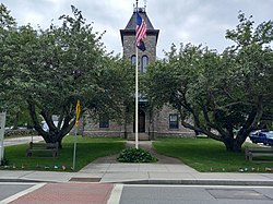
Kingston is a village and a census-designated place within the town of South Kingstown in Washington County, Rhode Island, United States, and the site of the main campus of the University of Rhode Island. The population was 6,974 at the 2010 census. Much of the village center is listed on the National Register of Historic Places as Kingston Village Historic District. It was originally known as Little Rest.

<span class="mw-page-title-main">Rhode Island Route 1A</span> State highway in Washington County, Rhode Island, US

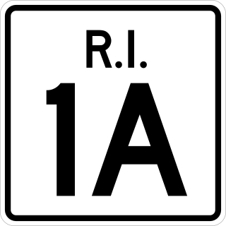
Route 1A, largely signed as Scenic 1A, is a 33.3-mile (53.6 km) long numbered state highway located in Washington County, Rhode Island, United States. The route, which parallels U.S. Route 1 for its entire length, has four distinct sections connected by US 1, two of which require median u-turn ramps to cross US 1. It travels through five towns in Washington County: Westerly, Charlestown, South Kingstown, Narragansett, and North Kingstown.

<span class="mw-page-title-main">Rhode Island Route 108</span> State highway in Rhode Island, US

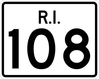
Route 108 is a 8.6-mile-long (13.8 km) state highway in Washington County, Rhode Island. The route begins at an intersection with Ocean Road in the village of Narragansett Pier, just north of Point Judith Light. The route's northern terminus is at an intersection with Route 138 in the town of South Kingstown, just east of the University of Rhode Island. In between, Route 108 connects to the Block Island Sound community of Galilee and passes through the villages of Wakefield and Peace Dale.

RISN Operations Inc., also called Rhode Island Suburban Newspapers, is a privately owned publisher of three daily newspapers and several weekly newspapers in the U.S. state of Rhode Island. The company was founded by Illinois-based newspaper executives in early 2007 to purchase the Rhode Island holdings of Journal Register Company, which it did for $8.3 million.

Independent Newspapers is an independent publisher of a weekly newspaper, The Independent, and a magazine, South County Life, in Washington County, Rhode Island.

<span class="mw-page-title-main">U.S. Route 1 in Rhode Island</span> Section of U.S. Route in Rhode Island, United States

U.S. Route 1 (US 1) is a major north–south U.S. Route through the U.S. state of Rhode Island, specifically within the Providence metropolitan area. Staying close to the Atlantic Ocean and Narragansett Bay, it is a longer route than Interstate 95 (I-95), and many portions are a four-lane divided highway.

<span class="mw-page-title-main">University of Rhode Island</span> Public university in Kingston, Rhode Island, U.S.

The University of Rhode Island (URI) is a public land-grant research university with its main campus in Kingston, Rhode Island, United States. It is the flagship public research as well as the land-grant university of Rhode Island. The university is classified among "R2: Doctoral Universities – High research activity". As of 2019, the URI enrolled 14,653 undergraduate students, 1,982 graduate students, and 1,339 non-degree students, making it the largest university in the state.

<span class="mw-page-title-main">South County History Center</span>

The South County History Center, which formerly operated as the Pettaquamscutt Historical Society, is a nonprofit organization in Kingston, Rhode Island, United States, that preserves and interprets the material culture of South County through exhibits and study of archival, library and artifact collections.

Matunuck is a village in South Kingstown, Rhode Island, near Charlestown, Rhode Island. It is located on a point along the southern Atlantic coast of Rhode Island off U.S. Route 1. The village takes its name from an Indian word meaning "lookout". The Narragansett tribe made a summer encampment at this location before the land was sold to colonists as part of the Pettaquamscutt purchase.

<span class="mw-page-title-main">Narragansett Pier Railroad</span> Defunct railroad in Rhode Island

The Narragansett Pier Railroad was a railroad in southern Rhode Island, running 8 miles (13 km) from West Kingston to Narragansett Pier. It was built by the Hazard Family of Rhode Island to connect their textile mills in Peace Dale and Wakefield to the New York, Providence and Boston Railroad at Kingston Station as well as to ocean-going steamboats at Narragansett Pier. Passenger service ran on the line from 1876 to 1952; the line continued freight operation as a Class III railroad until 1981. Most of the right-of-way has been converted to the William C. O'Neill Bike Path.

<span class="mw-page-title-main">Tavern Hall Preservation Society</span>

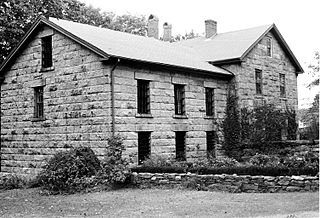
The Tavern Hall Preservation Society is a not-for-profit corporation dedicated to the preservation and upkeep of the Elisha Reynolds House (1738) in Kingston, Rhode Island. The society was founded as the Tavern Hall Club in 1911 to foster understanding and cooperation between the people of the Village of Kingston and the nearby Rhode Island State College community.

<span class="mw-page-title-main">Washington County, Rhode Island</span> County in Rhode Island, United States

Washington County, known locally as South County, is a county located in the U.S. state of Rhode Island. As of the 2020 census, the population was 129,839. Rhode Island counties have no governmental functions other than as court administrative boundaries, which are part of the state government.

William DeWitt Metz was an American historian specializing in Rhode Island History. He served as chairman of the Department of History at the University of Rhode Island, retiring after 45 years at the university in 1982. He was especially noted for promotion of heritage conservation and historical preservation activities throughout Rhode Island.

References

  1. "South Kingstown Rhode Island". City-Data.com. Retrieved October 22, 2012.
  2. "Town Council | South Kingstown, RI".
  3. "Staff Directory • South Kingstown, RI • CivicEngage".
  4. "U.S. Census website". United States Census Bureau . Retrieved January 31, 2008.
  5. "US Board on Geographic Names". United States Geological Survey. October 25, 2007. Retrieved January 31, 2008.
  6. "Early History". Narrangansett Indian Tribe. Archived from the original on December 3, 2022. Retrieved December 3, 2022.
  7. 1 2 "1638 Deed to Providence – Sowams Heritage Area". March 29, 2021. Retrieved December 3, 2022.
  8. Butler, Jo Ann (June 29, 2014). "Rebel PuritAn: Resurrecting Pettaquamscutt". Rebel PuritAn. Retrieved December 3, 2022.
  9. "Pettaquamscutt Rock Commemorated, May 11, 1958". smallstatebighistory.com. Retrieved December 3, 2022.
  10. 1 2 3 4 5 Rhode Island History (PDF). Vol. 45. 110 Benevolent Street, Providence, Rhode Island: Rhode Island Historical Society. 1986.{{cite book}}: CS1 maint: location (link)
  11. 1 2 Field, Edward (1902). State of Rhode Island and Providence Plantations at the End of the Century: A History. Mason Publishing Company.
  12. "PRISM Climate Group at Oregon State University". Northwest Alliance for Computational Science & Engineering (NACSE), based at Oregon State University. Retrieved March 16, 2023.
  13. "Census of Population and Housing". Census.gov. Retrieved June 4, 2016.
  14. "Peace Dale Museum of Art and Culture" . Retrieved May 20, 2022.
  15. "The great swamp fight" . Retrieved October 31, 2015.
  16. Pettaquamscutt Historical Society. "Scenic and Historic Driving Tour of South Kingstown". pettaquamscutt.org. Retrieved October 31, 2015.
  17. "ABOUT US | Ocean State Waves". oceanstatewaves.com. Retrieved January 21, 2022.
  18. "Town of South Kingstown Rhode Island". Town of South Kingstown Rhode Island. Archived from the original on May 8, 2012. Retrieved October 22, 2012.
  19. "Town of South Kingstown Rhode Island". Town of South Kingstown Rhode Island. Retrieved November 27, 2017.
  20. "Town Council | South Kingstown, RI". www.southkingstownri.com. Retrieved January 24, 2022.
  21. "South Kingstown School District". South Kingstown School District. Retrieved August 21, 2019.
  22. "The University of Rhode Island". The University of Rhode Island. Archived from the original on November 8, 2013. Retrieved October 22, 2012.
  23. "Police Department | South Kingstown, RI". www.southkingstownri.com. Retrieved January 24, 2022.
  24. "What We Do". Union Fire District. Retrieved January 24, 2022.
  25. "South County Health - Contact Us". www.southcountyhealth.org. Retrieved January 25, 2022.