Webster, Massachusetts

Last updated

Webster, Massachusetts
Town of Webster [1]
Webster, Massachusetts town hall.jpg
Town Hall in Webster, Massachusetts
Flag of Webster, Massachusetts.jpg
Seal of Webster, Massachusetts.png
Worcester County Massachusetts incorporated and unincorporated areas Webster highlighted.svg
Coordinates: 42°03′00″N71°52′50″W / 42.05000°N 71.88056°W / 42.05000; -71.88056
Country United States
State Massachusetts
County Worcester
Settled1713
Incorporated1832
Government
  Type Open town meeting
  Town
   Administrator
Richard LaFond
  Board of SelectmenChairman
Randy Becker, Secretary
Donald D. Bourque
Earl Gabor
Lisa Kontoes
Tom Klebart
Area
  Total14.5 sq mi (37.7 km2)
  Land12.5 sq mi (32.3 km2)
  Water2.1 sq mi (5.3 km2)
Elevation
460 ft (140 m)
Population
 (2020)
  Total17,776
  Density1,200/sq mi (470/km2)
Time zone UTC-5 (Eastern)
  Summer (DST) UTC-4 (Eastern)
ZIP Code
01570
Area code 508
FIPS code 25-73895
GNIS feature ID0618389
Website www.webster-ma.gov
Main Street in Webster Webster massachusetts marshall.jpg
Main Street in Webster

Webster is a town in Worcester County, Massachusetts, United States. The population was 17,776 at the 2020 census. [2]

Contents

Named after statesman Daniel Webster, the town was founded by industrialist Samuel Slater, and was home to several early American textile mills. It is home to the Chaubunagungamaug Reservation of the Nipmuc, as well as Lake Chaubunagungamaug, the third largest body of freshwater, and largest natural lake, in Massachusetts.

History

The area that is now Webster was the ancestral home of the Nipmuc people for thousands of years. It was first colonized by Europeans in 1713 and was officially incorporated on March 6, 1832. The area forming the town had previously been divided among the town of Dudley, the town of Oxford and an unincorporated gore. The primary founder was the manufacturer Samuel Slater, who came to the area after his celebrated activities in Pawtucket, Rhode Island, and founded several textile mills, one of which was taken over by the Cranston Print Works in 1936. [3] He named the town after his friend Daniel Webster. Slater spent his last years in Webster and died and is buried there in Mount Zion Cemetery. [4]

Geography

According to the U.S. Census Bureau, the town has a total area of 14.5 square miles (38 km2), of which 12.5 square miles (32 km2) is land and 2.0 square miles (5.2 km2), or 14.10%, is water.

The town is bounded on the north by Oxford; on the east by Douglas; on the south by Thompson, Connecticut, and on the west by Dudley, with which it is most closely tied culturally and politically.[ citation needed ]

The town is home to Lake Chargoggagoggmanchauggagoggchaubunagungamaugg, also known as Lake Chaubunagungamaug or simply "Webster Lake", the third largest lake in Massachusetts. The 45-character name is often regarded as the longest place name in the United States of America and the third longest in the world.

Demographics

St. Joseph Basilica in Webster Webster-basilica-exterior1.png
St. Joseph Basilica in Webster

As of the 2000 census, [16] of 2000, there were 16,415 people, 6,905 households, and 4,274 families residing in the town. The population density was 1,314.2 inhabitants per square mile (507.4/km2). There were 7,554 housing units at an average density of 604.8 per square mile (233.5/km2). The racial makeup of the town was 94.82% White (92.9% if non-Hispanic whites are counted), [17] 1.11% Black or African American, 0.34% Native American, 0.95% Asian, 1.49% from other races, and 1.29% from two or more races. Hispanic or Latino of any race were 3.95% of the population. About 60% of the Latinos were Puerto Ricans. [17]

The town is known for incorporating many Polish-American immigrants. Persons of Polish descent may constitute as much a third of the town's population.[ citation needed ] St. Joseph Basilica, the oldest Polish-American Catholic parish church in New England, is located in Webster.

As of 2000, there were 6,905 households, out of which 28.2% had children under the age of 18 living with them, 45.4% were married couples living together, 11.8% had a female householder with no husband present, and 38.1% were non-families. 31.7% of all households were made up of individuals, and 13.5% had someone living alone who was 65 years of age or older. The average household size was 2.34 and the average family size was 2.94.

In the town, the population was spread out, with 23.2% under the age of 18, 7.4% from 18 to 24, 30.6% from 25 to 44, 22.2% from 45 to 64, and 16.7% who were 65 years of age or older. The median age was 38 years. For every 100 females, there were 92.8 males. For every 100 females age 18 and over, there were 88.9 males.

The median income for a household in the town was $38,169, and the median income for a family was $48,898. Males had a median income of $37,863 versus $26,912 for females. The per capita income for the town was $20,410. About 8.1% of families and 11.0% of the population were below the poverty line, including 12.7% of those under age 18 and 14.5% of those age 65 or over.

Chaubunagungamaug Reservation

Chaubunagungamaug Reservation, a state-recognized Nipmuc Indian reservation, is located within the town. There are over 500 tribe members officially recognized by the Commonwealth of Massachusetts, but they are not recognized as a tribal government by the Bureau of Indian Affairs. [18]

Education

Public schools in Webster include Park Avenue School (grades K–4), Webster Middle School (grades 5–8), and Bartlett High School (grades 9–12). Webster Middle School opened in 2005, replacing the former Anthony J. Sitkowski Middle School, a building attached to Town Hall which is now an apartment building for senior citizens.

Three of Webster's Catholic churches also support elementary schools: St. Anne's (Sacred Heart Parish), St. Joseph's, and St. Louis. In 2016, St. Anne's and St. Louis's were combined to form All Saints Academy.

Economy

MAPFRE Insurance (formerly the Commerce Insurance Group) is based in Webster.

Indian Ranch is a summer concert venue located on Webster Lake, and has hosted musical acts such as Charlie Daniels, Thomas Rhett, The Barenaked Ladies, Scotty McCreery, Third Eye Blind, Huey Lewis and the News, Gavin DeGraw, and others. It is currently home to Indian Princess, a riverboat that once rode the Mississippi River, where guests can tour the lake.

Goya Foods has its Massachusetts division in Webster. [19]

Government

State government
State Representative(s):Joseph D. McKenna (R)
State Senator(s):Ryan Fattman (R)
Governor's Councilor(s):Paul DePalo (D)
Federal government
U.S. Representative(s): James P. McGovern (D-2nd District)
U.S. Senators: Elizabeth Warren (D), Ed Markey (D)

Media

Chester C. Corbin Library in Webster Webster, Massachusetts public library.jpg
Chester C. Corbin Library in Webster

Library

Webster's public library opened in 1889. [20] [21] In fiscal year 2008, the town of Webster spent 1.07% ($299,159) of its budget on its public library—approximately $17 per person ($22.40 adjusted for inflation to 2022). [22]

The Chester C. Corbin Library opened in 1921 [23] and served the town until being demolished in the fall of 2016, with its contents temporarily moved to the Webster Town Hall while a new building was constructed. The new library, named for Gladys E. Kelly, opened in 2018. [24]

Notable people

See also

Related Research Articles

<span class="mw-page-title-main">Gill, Massachusetts</span> Town in Massachusetts, United States

Gill is a town in Franklin County, Massachusetts, United States. The population was 1,551 at the 2020 census. It is part of the Springfield, Massachusetts Metropolitan Statistical Area. The campus of Northfield Mount Hermon School is located in the Mount Hermon section of the town.

<span class="mw-page-title-main">Montague, Massachusetts</span> Town in Massachusetts, United States

Montague is a town in Franklin County, Massachusetts, United States. The population was 8,580 at the 2020 census. It is part of the Springfield, Massachusetts metropolitan statistical area.

<span class="mw-page-title-main">Plympton, Massachusetts</span> Town in Massachusetts, United States

Plympton is a town in Plymouth County, Massachusetts, United States. The population was 2,930 at the 2020 census. The United States senator William Bradford was born here.

<span class="mw-page-title-main">Blackstone, Massachusetts</span> Town in Massachusetts, United States

Blackstone is a town in Worcester County, Massachusetts, United States. The population was 9,208 at the 2020 census. It is a part of the Providence metropolitan area.

<span class="mw-page-title-main">Douglas, Massachusetts</span> Town in Massachusetts, United States

Douglas is a town in Southern Worcester County, Massachusetts, United States. The population was 8,983 at the 2020 census. It includes the sizable Douglas State Forest, managed by the Department of Conservation and Recreation (DCR).

<span class="mw-page-title-main">Dudley, Massachusetts</span> Town in Massachusetts, United States

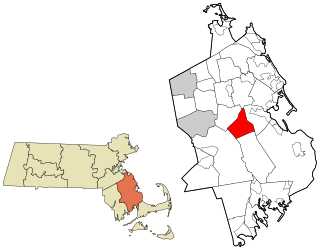
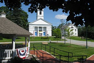
Dudley is a town in Worcester County, Massachusetts, United States. The population was 11,921 at the 2020 census.

<span class="mw-page-title-main">Grafton, Massachusetts</span> Town in Massachusetts, United States

Grafton is a town in Worcester County, Massachusetts, United States. The population was 19,664 at the 2020 census. The town consists of the North Grafton, Grafton, and South Grafton geographic areas, each with a separate ZIP Code. Incorporated in 1735, the town is home to a Nipmuc village known as Hassanamisco Reservation, the Willard House and Clock Museum, Community Harvest Project, and the Tufts University Cummings School of Veterinary Medicine. Grafton operates the state's largest on-call fire department, with 74 members.

<span class="mw-page-title-main">Mendon, Massachusetts</span> Town in Massachusetts, United States

Mendon is a town in Worcester County, Massachusetts, United States. The population was 6,228 at the 2020 census. Mendon is part of the Blackstone River Valley National Heritage Corridor, an early center of the industrial revolution in the United States. Mendon celebrated its 350th anniversary on May 15, 2017.

<span class="mw-page-title-main">Oakham, Massachusetts</span> Town in Massachusetts, United States

Oakham is a town in Worcester County, Massachusetts, United States. The population was 1,851 at the 2020 census.

<span class="mw-page-title-main">Paxton, Massachusetts</span> Town in Massachusetts, United States

Paxton is a town in Worcester County, Massachusetts, United States. The population was 5,004 at the 2020 census.

<span class="mw-page-title-main">Royalston, Massachusetts</span> Town in Massachusetts, United States

Royalston is a town in Worcester County, Massachusetts, United States. The population was 1,250 at the 2020 census.

<span class="mw-page-title-main">Shrewsbury, Massachusetts</span> Town in Massachusetts, United States

Shrewsbury is a town in Worcester County, Massachusetts, United States. The population was 38,325 according to the 2020 United States Census, in nearly 15,000 households.

<span class="mw-page-title-main">Sutton, Massachusetts</span> Town in Massachusetts, United States

Sutton, officially the Town of Sutton, is a town in Worcester County, Massachusetts, United States. The population was 9,357 in the 2020 United States Census. Located in the Blackstone Valley, the town was designated as a Preserve America community in 2004.

<span class="mw-page-title-main">Upton, Massachusetts</span> Town in Massachusetts, United States

Upton is a town in Worcester County, Massachusetts, United States. It was first settled in 1728. The population was given as exactly 8,000 at the 2020 census.

<span class="mw-page-title-main">Westminster, Massachusetts</span> Town in Massachusetts, United States

Westminster is a town in Worcester County, Massachusetts, United States. At the 2020 census, the town population was 8,213.

<span class="mw-page-title-main">Marshfield, Massachusetts</span> Town in Massachusetts, United States

Marshfield is a town in Plymouth County, Massachusetts, United States, on Massachusetts's South Shore. The population was 25,825 at the 2020 census.

<span class="mw-page-title-main">Lunenburg, Massachusetts</span> Town in Massachusetts, United States

Lunenburg is a town in Worcester County, Massachusetts, United States. The population was 11,946 at the 2020 census.

<span class="mw-page-title-main">Rutland, Massachusetts</span> Town in Massachusetts, United States

Rutland is a town in Worcester County, Massachusetts, United States. The population was 9,049 at the 2020 census. Rutland is the geographic center of Massachusetts; a tree, the Central Tree, located on Central Tree Road, marks the general spot.

<span class="mw-page-title-main">Webster/Dudley Band of Chaubunagungamaug Nipmuck Indians</span>

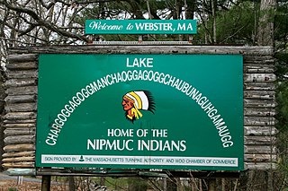
The Webster/Dudley Band of Chaubunagungamaug Nipmuck Indians, also known as the Chaubunagungamaug, Chaubunagungamaug Nipmuck, Pegan or Dudley/Webster Indians, is a cultural heritage group that claims descent from the Nipmuc people. They are a state-recognized tribe by the Commonwealth of Massachusetts.

<span class="mw-page-title-main">Northborough, Massachusetts</span> Town in Massachusetts, United States

Northborough is a town in Worcester County, Massachusetts, United States. The official spelling of the town's name is "Northborough," but the alternative spelling "Northboro" is also used. The population was 15,741 at the 2020 census.

References

  1. https://www.webster-ma.gov/DocumentCenter/View/6839/FINAL-APPROVED-CHARTER
  2. "Census - Geography Profile: Webster town, Worcester County, Massachusetts".
  3. "The History of Cranston Print Works". www.cpw.com. Archived from the original on August 17, 2000.
  4. "Welcome to Olde Webster". Archived from the original on August 8, 2019.
  5. "Total Population (P1), 2010 Census Summary File 1". American FactFinder, All County Subdivisions within Massachusetts. United States Census Bureau. 2010.
  6. "Massachusetts by Place and County Subdivision - GCT-T1. Population Estimates". United States Census Bureau. Retrieved July 12, 2011.
  7. "1990 Census of Population, General Population Characteristics: Massachusetts" (PDF). US Census Bureau. December 1990. Table 76: General Characteristics of Persons, Households, and Families: 1990. 1990 CP-1-23. Retrieved July 12, 2011.
  8. "1980 Census of the Population, Number of Inhabitants: Massachusetts" (PDF). US Census Bureau. December 1981. Table 4. Populations of County Subdivisions: 1960 to 1980. PC80-1-A23. Retrieved July 12, 2011.
  9. "1950 Census of Population" (PDF). Bureau of the Census. 1952. Section 6, Pages 21-10 and 21-11, Massachusetts Table 6. Population of Counties by Minor Civil Divisions: 1930 to 1950. Retrieved July 12, 2011.
  10. "1920 Census of Population" (PDF). Bureau of the Census. Number of Inhabitants, by Counties and Minor Civil Divisions. Pages 21-5 through 21-7. Massachusetts Table 2. Population of Counties by Minor Civil Divisions: 1920, 1910, and 1920. Retrieved July 12, 2011.
  11. "1890 Census of the Population" (PDF). Department of the Interior, Census Office. Pages 179 through 182. Massachusetts Table 5. Population of States and Territories by Minor Civil Divisions: 1880 and 1890. Retrieved July 12, 2011.
  12. "1870 Census of the Population" (PDF). Department of the Interior, Census Office. 1872. Pages 217 through 220. Table IX. Population of Minor Civil Divisions, &c. Massachusetts. Retrieved July 12, 2011.
  13. "1860 Census" (PDF). Department of the Interior, Census Office. 1864. Pages 220 through 226. State of Massachusetts Table No. 3. Populations of Cities, Towns, &c. Retrieved July 12, 2011.
  14. "1850 Census" (PDF). Department of the Interior, Census Office. 1854. Pages 338 through 393. Populations of Cities, Towns, &c. Retrieved July 12, 2011.
  15. "City and Town Population Totals: 2020−2022". United States Census Bureau . Retrieved November 24, 2023.
  16. "U.S. Census website". United States Census Bureau . Retrieved January 31, 2008.
  17. 1 2 "Census Fact Sheet for Webster". Archived from the original on February 12, 2020. Retrieved December 22, 2007.
  18. "Martin Issues Final Determination to Decline Federal Acknowledgment of The Nipmuc Nation". U.S. Department of the Interior. June 18, 2004. Archived from the original on September 29, 2006. Retrieved October 2, 2006.
  19. "Contact Us." Goya Foods. Retrieved on March 26, 2016. "Goya Foods of Massachusetts 5 Goya Drive Webster, MA 01570"
  20. C.B. Tillinghast. The free public libraries of Massachusetts. 1st Report of the Free Public Library Commission of Massachusetts. Boston: Wright & Potter, 1891.
  21. Chester C. Corbin Public Library. Retrieved November 10, 2010
  22. July 1, 2007, through June 30, 2008; cf. The FY2008 Municipal Pie: What's Your Share? Commonwealth of Massachusetts, Board of Library Commissioners. Boston: 2009. Available: Municipal Pie Reports Archived January 23, 2012, at the Wayback Machine . Retrieved August 4, 2010
  23. "History of the Webster library".
  24. Grand Opening at Webster's new Gladys E. Kelly Public Library, Blackstone Valley Xpress