Ashland, Massachusetts

Last updated

Ashland, Massachusetts
Ashland Public Library, April 2010, MA.jpg
Ashland Public Library (2010)
Flag of Ashland, Massachusetts.png
Seal of Ashland, Massachusetts.png
Nicknames: 
The Clock Town
The Home of the Electric Clock [1]
Middlesex County Massachusetts incorporated and unincorporated areas Ashland highlighted.svg
Location in Middlesex County in Massachusetts
USA Massachusetts location map.svg
Red pog.svg
Ashland
Location in Massachusetts
Usa edcp location map.svg
Red pog.svg
Ashland
Ashland (the United States)
North America laea location map.svg
Red pog.svg
Ashland
Ashland (North America)
Coordinates: 42°15′40″N71°27′50″W / 42.26111°N 71.46389°W / 42.26111; -71.46389
Country United States
State Massachusetts
County Middlesex
Settled1750
Incorporated1846
Government
  Type Open town meeting
   Town Manager Michael Herbert
Area
  Total12.9 sq mi (33.5 km2)
  Land12.4 sq mi (32.2 km2)
  Water0.5 sq mi (1.2 km2)
Elevation
188 ft (57 m)
Population
 (2020 [2] )
  Total18,832
  Density1,518.7/sq mi (584.8/km2)
Time zone UTC-5 (Eastern)
  Summer (DST) UTC-4 (Eastern)
ZIP code
01721
Area code 508 / 774
FIPS code 25-02130
GNIS feature ID0619394
Website www.ashlandmass.com

Ashland is a town in Middlesex County, Massachusetts, United States. It is part of the MetroWest region. The population was 18,832 at the 2020 United States census.

Contents

History

The area now known as Ashland was settled in the early 18th century and inhabited prior to that by the Megunko Native Americans, to which Megunko Hill owes its name. Previously known as "Unionville", Ashland was incorporated in 1846, bearing the name of statesman Henry Clay's Kentucky estate. It is considerably younger than many of the surrounding towns, as Ashland's territory was taken in near-equal parts from the previously established towns of Hopkinton, Holliston (previously of colonial era Sherborn's territory), and Framingham.

The construction of the Boston & Worcester Railroad, later the Boston & Albany, in the 1830s was key to the early development of the town. Decades later, two other rail lines opened stations in Ashland. Along with the Sudbury River, the railroad helped to attract numerous mills to develop a bustling boot and shoe industry. However, by constructing three reservoirs along the river in 1878, the Boston Water Board inadvertently stymied further growth, most notably by halting the construction of the Dwight Printing Company's granite mills. [3] Although the mills closed, starting in the 1890s the Hopkinton Railroad Company, providing a connection to Milford, and the Natick Street Railway, which operated streetcars between the towns of Sherborn, Framingham, and Natick, offered service in Ashland. [4] These rail lines were gone by the 1920s, rendered obsolete by automobiles. [4]

Around the same time that the local rail lines were in decline, the inventor Henry E. Warren developed the Warren Synchronizing Timer in 1916, which made synchronous electric clocks possible by keeping alternating current flowing from power plants at a consistent sixty cycles per second. [5] Warren founded Telechron, which, in partnership with General Electric, manufactured electric clocks in Ashland until 1979, thirteen years before Telechron itself became defunct. [6] A Warren Synchronizing Timer is on display at the Smithsonian's Museum of American History in Washington D.C., [7] and the Ashland High School sports teams are called "The Clockers".

For most of the 20th century, Ashland's population remained slow in growth, until the post-war boom beginning in the 1950s. During that period, Ashland grew from a far-removed rural town 22 miles (35 km) west of Boston to a primarily residential suburb by the 1980s. Over time, many farms and open spaces have given way to housing, although some untouched land still remains, including the Ashland Town Forest, Ashland State Park, Warren Woods, and land comprising the beach and dam portions of Hopkinton State Park.

Two major routes, 135 and 126, pass through Ashland. Route 135 is dominated by older residential development of varying density and is also part of the route for the Boston Marathon, which began in Ashland on Pleasant Street until the start was moved to Hopkinton's Main Street in 1924. [8] Route 126 has developed rapidly since the 1980s, as farms have given way to shopping centers and condominiums. A part of the draw of Ashland, and one that has been publicized in recent years, is its "ideal" location [1] about halfway between the cities of Boston and Worcester. Travel is easy, with its own stop on the Framingham/Worcester Commuter Rail Line and nearby access to both I-90 and I-495. Ashland is considered part of MetroWest, which also consists of the towns of Framingham, Holliston, and Hopkinton.

Even though Ashland has left its humble roots as a rural area, it still retains the look and feel of a typical residential Boston-area New England town. Traditions like Ashland Day and small-town favorites like the ice cream shop Murphy's and breakfast joint Sunnyside Cafe maintain the feeling of a close-knit community. Ashland's longstanding rival for the Thanksgiving Day football game is Hopkinton, a rivalry with roots in the formation of the town and the resulting 1846 dispute concerning Ashland's fire engine "Megunko 1." [9]

Geography

According to the United States Census Bureau, the town has a total area of 12.9 square miles (33 km2), of which 12.4 square miles (32 km2) is land and 0.5 square miles (1.3 km2) (3.72%) is water.

Adjacent towns

Ashland is located in eastern Massachusetts, bordered by:

Climate

Ashland's climate is typical for New England. Winters are variably cold, with frequent Nor'easters and occasional blizzards. Snowfall ranges widely from season to season, although the average is about 40–50 inches (100–130 cm). In the recent past, there has been as little as 14 inches (360 mm) of snow (in the 1988–89 winter season) to 148 inches (in 1995–1996). The amount decreases dramatically eastward towards Boston because of the influence of the Atlantic Ocean. Snowfall amounts can also decrease rapidly south of Ashland. Low temperatures below zero are not uncommon in winter, and the lowest recent temperatures have been 17 below in January 1994, 14 below in January 2011 and 16 below in February 2016. Average January high temperatures are in the low 30s. Average January low temperatures are in the upper teens. Snow depth can reach two feet or more during the winter season. The winter of 2010–2011 was notable for snow depths of nearly 40 inches during January and February. Nearly 60 inches of snowfall was recorded in Ashland in January 2011 alone. The winter of 2014–2015 saw a very cold February and March. Snow cover lasted from late January until the first week of April. February 2015 was one of the coldest months on record. Snowfall for Ashland was 107.6" for the season. Snow depth reached 45". Spring temperatures can be mitigated by penetrating cold fronts originating from the Canadian Maritimes, known as "backdoor cold fronts". Typically, high temperatures consistently above 70 degrees do not set in until late May. The last frost is usually in mid-May. Summers are generally comfortable, with periods of high humidity. Prolonged heat waves of three or more days with highs of 90 or above are uncommon but can occur. In July 2011 an unusually high temperature of 101 was reached. Average July high temperatures are in the low 80s and average lows are around 60. Severe summer weather is not as common as in areas to the west in Central Massachusetts. However, on July 10, 1989, high winds occurred, causing widespread tree damage through most of Ashland with several homes damaged. This storm was part of a complex of severe storms that spawned several EF0 and EF1 tornadoes in towns in some neighboring counties. [10] Fall is pleasant with the first frost usually around October 1, and the peak of the fall foliage season averages around October 12. Ashland can expect a "white" Christmas slightly over 50 percent of the time.

Demographics

Historical population
YearPop.±%
1850 1,304    
1860 1,554+19.2%
1870 2,186+40.7%
1880 2,394+9.5%
1890 2,532+5.8%
1900 1,525−39.8%
1910 1,682+10.3%
1920 2,287+36.0%
1930 2,307+0.9%
1940 2,479+7.5%
1950 3,500+41.2%
1960 7,779+122.3%
1970 8,882+14.2%
1980 9,165+3.2%
1990 12,066+31.7%
2000 14,674+21.6%
2010 16,593+13.1%
2020 18,832+13.5%
2022*18,466−1.9%
* = population estimate.
Source: United States census records and Population Estimates Program data. [11] [12] [13] [14] [15] [16] [17] [18] [19] [20] [21]

At the 2010 census, [22] there were 16,593 people, 6,385 households and 4,531 families residing in the town. The population density was 1,338.1 inhabitants per square mile (516.6/km2). There were 6,609 housing units at an average density of 533.0 per square mile (205.8/km2). The racial makeup of the town was 84.2% White, 2.4% African American, 0.1% Native American, 8.8% Asian, 2.6% from other races, and 1.9% from two or more races. Hispanic or Latino of any race were 4.5% of the population.

There were 6,484 households, of which 36.7% had children under the age of 18 living with them, 59.0% were married couples living together, 2.7% had a male householder with no wife present, 8.5% had a female householder with no husband present, and 29.8% were non-families. 24.9% of all households were made up of individuals, and 9.1% had someone living alone who was 65 years of age or older. The average household size was 2.51 and the average family size was 3.04.

Of the 16,593 people in the population, 24.9% were under the age of 18, 5.5% were 15 to 19 years of age, 4.1% were 20 to 24 years of age, 27.9% were 25 to 44 years of age, 30.7% were 45 to 64 years of age, and 10.9% were 65 years and over. The median age was 40.1 years. For every 100 females, there was 94.6 males. For every 100 females 18 years and over there were 92.0 males.

The median household income was $93,770, and the median family income was $116,799. The median income of individuals working full-time was $79,485 for males versus $60,720 for females. The per capita income for the town was $46,626. About 2.2% of families and 4.0% of the population were below the poverty line, including 3.7% of those under age 18 and 9.6% of those age 65 or over.

Education

In 2005, the town completed the new high school and revised the division of grades. These changes include the 6th grade being moved to join the 7th and 8th grades in the former high school to form what is now Ashland Middle School and moving the 3rd grade from the Henry E. Warren Elementary School into the Mindess Elementary School to join the 4th and 5th grades. The 8th grade students have an annual short field trip to Washington D.C. The kindergarten, 1st and 2nd grades are in the Henry E. Warren Elementary School and preschool is in the William Pittaway School. The graduating class of 2007 was the first class to complete a full year in the new high school. In 2009, a new program at Ashland High School encouraged teachers to "bridge the gap between subjects like math and history to the art world and visually engage students with traditional subject matter." This allowed students to make a connection between the material they were learning in the classroom and the knowledge of the arts and culture. [23]

Points of interest

Ashland Farmer's Market

This local farmers market has been operating on Saturdays 9am-1pm June–October each year since 2012. Around two dozen vendors sell fresh fruit, vegetables, meat, fish, bread, deserts, local wines, and crafts along with ready to eat food and coffee. There is also a rotating menu of live music and children's activities.

Ashland Day

Ashland Day is typically held on the third Saturday in September, each year. The festivities occur near the center of town at Stone Park from the morning until the late afternoon, and include a number of booths and various carnival-like rides. Many of the school system's athletic clubs and organizations use the day as an annual fundraising event, but it serves primarily as a day for residents to enjoy numerous activities and delicious food. Traditionally, there are fireworks atop the dam at Hopkinton State Park (the dam is in Ashland), but budget cuts have canceled several recent displays. Ashland Day has only been canceled once, due to inclement weather, in 2004. The 25th Anniversary of the event, was held in 2010. For the first time in several years, fireworks were once again launched from atop the dam at Hopkinton State Park. [24]

Stone's Public House

Stone's Public House, c. 2008 Stone's Public House, Ashland, Massachusetts.jpeg
Stone's Public House, c.2008

Built in 1832 by Captain John Stone, to capitalize on the new Boston and Worcester Railroad, The Railroad House, later renamed John Stone's Inn, and now known as Stone's Public House, is located in the center of Ashland. [25]

Stone's is reportedly the site of multiple hauntings. According to legend, the Inn was the site of a murder. Captain Stone is said to have killed a New York salesman named Mike McPherson accidentally after hitting him over the head with a pistol when he suspected McPherson of cheating at poker. [26] It is said that Stone and three friends with whom he had been playing swore to keep the event secret and buried the salesman's body in the Inn's basement. The legend contends that the ghosts of the salesman and the three other players involved all roam the inn. No body has ever been found. [27]

It is rumored that a ten-year-old girl, Mary J. Smith, was struck by a train while playing on the railroad tracks just outside the inn, on June 11, 1862. Onlookers rushed her inside the inn, where she would later succumb to her wounds. A number of employees, patrons, and passersby have reported seeing the apparition of a young girl in a dress, with most reports detailing her looking out various windows that overlook the rear of the building. [28]

The inn was purchased from Herve Beaudoin in 1976 by Leonard "Cappy" Fournier and renovated. During renovations, a hidden chamber was discovered in the basement, and it is speculated that this was used to house runaway slaves who made their way to freedom in the North along the Underground Railroad. [29]

One notable guest of the hotel, Daniel Webster, gave a speech from the balcony on the day the first train arrived in 1834. Joining him for the inaugural train were Governor John Davis and former Governor Levi Lincoln Jr. [25]

Marathon History

Ashland was the original start line for the Boston Marathon from 1897 to 1923. As traditional marathon distances grew, the start line needed to be pushed back to Hopkinton in 1924. There is a small park on Pleasant street in Ashland to remember this history, featuring a sign that reads "It all started here". ref ref

Open Space

Ashland State Park, Hopkinton State Park, Ashland Town Forest, and Warren Woods are all either completely or partially located within town lines. Both state parks include a lake with hiking, fishing, biking and Swimming. Hopkinton State Park also has boat rentals and horseback riding trails. [30] Ashland State Park is 470 acres including a 157-acre reservoir, the 3.5 mile hiking loop around it passes a boat launch, beach, dam and spillway. The Ashland Town Forest is 550 acres with hiking trails around rock outcroppings, small caves and the rumored ending of some women who escaped the Salem Witch Trials. [31] The town also owns 100+ acres of land called "Warren Woods" on the South side of town with hiking trails across land once owned by Henry Warren.

Nyanza

US Color and Chemical Company, later named New England Aniline Works, Inc., and finally The Nyanza Color and Chemical Company, had a dye-manufacturing plant in Ashland. The plant opened in 1917 when American entry into World War I cut off the supply of dyes from Germany, then the world's principal source. In 1971, the factory was identified as a hazard when pollution was discovered in the nearby Sudbury River. The site was placed on the Superfund National Priority List in 1982 when heavy metals and organochlorides were discovered in the soil and water near the site. It was also deemed probable that particles of mercuric sulfate were blown into the air. In 1998, Trustees settled NRD claims with the responsible parties at the Nyanza Chemical Waste Dump Superfund Site for $3 million. $230,769 of the settlement is for groundwater resources. [32] Cleaning up the contaminated site cost residents $55 million, and is still not complete as of 2013. The estates of the Nyanza executives were charged for the cleanup.

In 2006, the Massachusetts State Department of Public Health released a study that found that people who grew up in Ashland between the late 1960s and early 1980s and swam in the waters near Nyanza had a 200-300% higher incidence of cancer than those who were not exposed to the chemicals. [33]

In 2011, the Massachusetts Department of Environmental Protection's Bureau of Waste Site Cleanup's Natural Resource Damages (NRD) program settled with the slowly-going-bankrupt Nyanza for $3 million, which with interest has grown to almost $4 million. The Nyanza case had previously been at the NRD program of the Massachusetts Executive Office of Energy and Environmental Affairs.

In 2016, proposed housing near Nyanza site raised alarm in Ashland. [34]

In 2020, the EPA proposed a remedy to cleanup groundwater near the site, the final operable unit (phase) of the site cleanup. [35]

Sri Lakshmi Temple

Opened September 6, 1986, Sri Lakshmi Temple is a large regional Hindu temple located on Waverly Street and is the largest such temple in New England. Sri Lakshmi temple hosts several Hindu functions throughout the year. First housed in a Knights of Columbus Hall in Melrose in 1978 and later in the Needham Village Club, the congregation purchased about 12 acres (49,000 m2) of land from Ashland in 1981. [36]

Transportation

Commuter rail service from Boston's South Station is provided by the MBTA with the Ashland station on its Framingham/Worcester Line. The station is accessible from either Pleasant Street or Memorial Drive (which runs behind Ashland Middle School).

Notable people

See also

Related Research Articles

<span class="mw-page-title-main">Middlesex County, Massachusetts</span> County in Massachusetts, United States

Middlesex County is a county located in the Commonwealth of Massachusetts, United States. As of the 2020 census, the population was 1,632,002, making it the most populous county in both Massachusetts and New England and the 22nd most populous county in the United States. Middlesex County is one of two U.S. counties to be amongst the top 25 counties with the highest household income and the 25 most populated counties. It is included in the Census Bureau's Boston–Cambridge–Newton, MA–NH Metropolitan Statistical Area. As part of the 2020 United States census, the Commonwealth's mean center of population for that year was geo-centered in Middlesex County, in the town of Natick.

<span class="mw-page-title-main">Newton, Massachusetts</span> City in Massachusetts, United States

Newton is a city in Middlesex County, Massachusetts, United States. It is approximately 7 miles (11 km) west of downtown Boston, and comprises a patchwork of thirteen villages without a city center. It is home to the Charles River, Crystal Lake, and Heartbreak Hill, among other landmarks. It is served by several streets and highways, as well as the Green Line D branch run by the MBTA.

<span class="mw-page-title-main">Holliston, Massachusetts</span> Town in Massachusetts, United States

Holliston is a New England town in Middlesex County, Massachusetts, United States in the Greater Boston area. The population was 14,996 at the 2020 census. It is located in MetroWest, a Massachusetts region that is west of Boston. Holliston is the only town in Middlesex County that borders both Norfolk and Worcester counties.

<span class="mw-page-title-main">Marlborough, Massachusetts</span> City in Massachusetts, United States

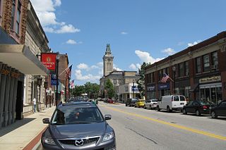
Marlborough is a city in Middlesex County, Massachusetts, United States. The population was 41,793 at the 2020 census. Marlborough became a prosperous industrial town in the 19th century and made the transition to high technology industry in the late 20th century after the construction of the Massachusetts Turnpike.

<span class="mw-page-title-main">Sherborn, Massachusetts</span> Town in Massachusetts, United States

Sherborn is a town in Middlesex County, Massachusetts, United States. Located in Boston's MetroWest region, the community is within area code 508 and has the ZIP code 01770. As of the 2020 U.S. Census, the town population was 4,401.

<span class="mw-page-title-main">Sudbury, Massachusetts</span> Town in Massachusetts, United States

Sudbury is a town in Middlesex County, Massachusetts, United States. At the 2020 census, it had a population of 18,934. The town, located in Greater Boston's MetroWest region, has a colonial history.

<span class="mw-page-title-main">Southborough, Massachusetts</span> Town in Massachusetts, United States

Southborough is a town in Worcester County, Massachusetts, United States. It incorporates the villages of Cordaville, Fayville, and Southville. Its name is often informally shortened to Southboro, a usage seen on many area signs and maps. At the 2020 census, its population was 10,450 in 3,542 households.

<span class="mw-page-title-main">Contoocook, New Hampshire</span> Census-designated place in New Hampshire, United States

Contoocook is a village and census-designated place (CDP) within the town of Hopkinton in Merrimack County, New Hampshire, United States. The population was 1,427 at the 2020 census. Contoocook is well known for its growth of small businesses, preservation of historical landmarks, community involvement and recreational activities within the village.

<span class="mw-page-title-main">Hopkinton, New Hampshire</span> Town in New Hampshire, United States

Hopkinton is a town in Merrimack County, New Hampshire, United States. The population was 5,914 at the 2020 census. The town has three distinct communities: Hopkinton village, mainly a residential area in the center of the town; Contoocook, the town's business hub, located in the north; and West Hopkinton, within the more agricultural portion of the town. The town is home to the Hopkinton State Fair, adjacent to Contoocook village, and to the historic Contoocook Railroad Depot and the Contoocook Railroad Bridge, the oldest covered railroad bridge in the United States.

<span class="mw-page-title-main">Framingham, Massachusetts</span> City in Massachusetts, US

Framingham is a city in the Commonwealth of Massachusetts, United States. Incorporated in 1700, it is located in Middlesex County and the MetroWest subregion of the Greater Boston metropolitan area. The city proper covers 25 square miles (65 km2) with a population of 72,362 in 2020, making it the 14th most populous municipality in Massachusetts. Residents voted in favor of adopting a charter to transition from a representative town meeting system to a mayor–council government in April 2017, and the municipality transitioned to city status on January 1, 2018. Before it transitioned, it had been the largest town by population in Massachusetts.

<span class="mw-page-title-main">Bourne, Massachusetts</span> Town in Massachusetts, United States

Bourne is a town in Barnstable County, Massachusetts, United States. The population was 20,452 at the 2020 census.

<span class="mw-page-title-main">Falmouth, Massachusetts</span> Town in Massachusetts, United States

Falmouth is a town in Barnstable County, Massachusetts, United States. The population was 32,517 at the 2020 census, making Falmouth the second-largest municipality on Cape Cod after Barnstable. The terminal for the Steamship Authority ferries to Martha's Vineyard is located in the village of Woods Hole in Falmouth. Woods Hole also contains several scientific organizations such as the Woods Hole Oceanographic Institution (WHOI), the Marine Biological Laboratory (MBL), the Woodwell Climate Research Center, NOAA's Woods Hole Science Aquarium, and the scientific institutions' various museums.

<span class="mw-page-title-main">Orleans, Massachusetts</span> Town in Massachusetts, United States

Orleans is a town in Barnstable County, Massachusetts situated along Cape Cod. The population was 6,307 at the 2020 census.

<span class="mw-page-title-main">Hopkinton, Massachusetts</span> Town in Massachusetts, United States

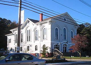
Hopkinton is a town in Middlesex County, Massachusetts, United States, 25 miles (40 km) west of Boston. The town is best known as the starting point of the Boston Marathon, held annually on Patriots' Day each April, and as the headquarters for the Dell EMC corporation.

<span class="mw-page-title-main">MetroWest</span> Region west of Boston and east of Worcester, in the U.S. state of Massachusetts

MetroWest is a cluster of cities and towns lying west of Boston and east of Worcester, in the U.S. state of Massachusetts. The name was coined in the 1980s by a local newspaper.

<span class="mw-page-title-main">Ashland State Park</span> State park in Middlesex County, Massachusetts

Ashland State Park is a public recreation area surrounding the 157-acre (64 ha) Ashland Reservoir in the town of Ashland, Massachusetts. The state park's 470 acres (190 ha) incorporate the entire shoreline of the reservoir, which is abutted by the Warren Conference Center and Inn of Framingham State University, town-owned land once the site of Camp Winnetaska, and residential houses. The park is managed by the Massachusetts Department of Conservation and Recreation.

<span class="mw-page-title-main">Sudbury River</span> River in Massachusetts, United States

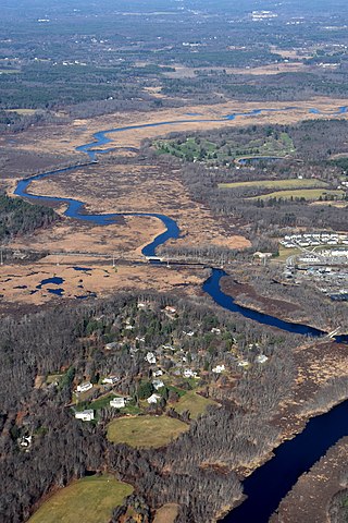
The Sudbury River is a 32.7-mile-long (52.6 km) tributary of the Concord River in Middlesex County, Massachusetts, in the United States.

<span class="mw-page-title-main">Ashland station (MBTA)</span> Railway station in Ashland, Massachusetts, US

Ashland station is an MBTA Commuter Rail station in Ashland, Massachusetts. It serves the Framingham/Worcester Line. It has a long driveway leading from the south parking lot to the intersection of West Union Street and Voyagers Lane. Like the other stations on the line west of Framingham, Ashland serves as a park-and-ride station with 678 parking spots.

<span class="mw-page-title-main">Westborough, Massachusetts</span> Town in Worcester County, Massachusetts, US

Westborough is a town in Worcester County, Massachusetts, United States. The population was 21,567 at the 2020 Census, in over 7,000 households. Incorporated in 1717, the town is governed under the New England open town meeting system, headed by a five-member elected Board of Selectmen whose duties include licensing, appointing various administrative positions, and calling a town meeting of citizens annually or whenever the need arises.

<span class="mw-page-title-main">John Stone (captain)</span> American farmer and landowner who became a captain in the militia

John Stone was an American farmer and landowner who became a captain in the militia.

References

  1. 1 2 "Ashland, MA - Official Website". Ashlandmass.com. Retrieved April 7, 2018.
  2. "Census - Geography Profile: Ashland town, Middlesex County, Massachusetts". Data.census.gov.
  3. "Ashland Communitywide Historic Properties Survey Final Report". ashlandmass.com. Retrieved April 7, 2018.
  4. 1 2 "The Train – Ashland Historical Society". Ashlandhistsociety.com. Retrieved April 7, 2018.
  5. Stoddard, Bill. ""Modern Electric Clocks" by Henry E. Warren". clockhistory.com. Retrieved April 7, 2018.
  6. Pappy. "What Came After". Telechron.net. Retrieved April 7, 2018.
  7. "About Henry Warren - the Warren Conference Center & Inn - Ashland, MA". Archived from the original on August 10, 2010. Retrieved August 20, 2010.
  8. "History | Boston Athletic Association". Baa.org. Archived from the original on March 7, 2012.
  9. "Stories of Ashland - the Magunco Tub". Archived from the original on July 27, 2010. Retrieved August 19, 2010.
  10. "National Climate Data Center". US Department of Commerce. Archived from the original on May 5, 2011. Retrieved April 17, 2011.
  11. "Total Population (P1), 2010 Census Summary File 1". American FactFinder, All County Subdivisions within Massachusetts. United States Census Bureau. 2010.
  12. "Massachusetts by Place and County Subdivision - GCT-T1. Population Estimates". United States Census Bureau. Retrieved July 12, 2011.
  13. "1990 Census of Population, General Population Characteristics: Massachusetts" (PDF). US Census Bureau. December 1990. Table 76: General Characteristics of Persons, Households, and Families: 1990. 1990 CP-1-23. Retrieved July 12, 2011.
  14. "1980 Census of the Population, Number of Inhabitants: Massachusetts" (PDF). US Census Bureau. December 1981. Table 4. Populations of County Subdivisions: 1960 to 1980. PC80-1-A23. Retrieved July 12, 2011.
  15. "1950 Census of Population" (PDF). Bureau of the Census. 1952. Section 6, Pages 21-10 and 21-11, Massachusetts Table 6. Population of Counties by Minor Civil Divisions: 1930 to 1950. Retrieved July 12, 2011.
  16. "1920 Census of Population" (PDF). Bureau of the Census. Number of Inhabitants, by Counties and Minor Civil Divisions. Pages 21-5 through 21-7. Massachusetts Table 2. Population of Counties by Minor Civil Divisions: 1920, 1910, and 1920. Retrieved July 12, 2011.
  17. "1890 Census of the Population" (PDF). Department of the Interior, Census Office. Pages 179 through 182. Massachusetts Table 5. Population of States and Territories by Minor Civil Divisions: 1880 and 1890. Retrieved July 12, 2011.
  18. "1870 Census of the Population" (PDF). Department of the Interior, Census Office. 1872. Pages 217 through 220. Table IX. Population of Minor Civil Divisions, &c. Massachusetts. Retrieved July 12, 2011.
  19. "1860 Census" (PDF). Department of the Interior, Census Office. 1864. Pages 220 through 226. State of Massachusetts Table No. 3. Populations of Cities, Towns, &c. Retrieved July 12, 2011.
  20. "1850 Census" (PDF). Department of the Interior, Census Office. 1854. Pages 338 through 393. Populations of Cities, Towns, &c. Retrieved July 12, 2011.
  21. "City and Town Population Totals: 2020−2022". United States Census Bureau . Retrieved November 25, 2023.
  22. "U.S. Census website". United States Census Bureau. Retrieved June 13, 2013.
  23. Hatch, K. (November 25, 2009). Bridging the gap between classes and art in ashland. Metrowest Daily News, 1.
  24. "Ashland Day Committee - Ashland, Massachusetts". Archived from the original on May 30, 2011. Retrieved August 24, 2010.
  25. 1 2 "The Train – Ashland Historical Society". ashlandhistsociety.com. Retrieved April 7, 2018.
  26. "The Mysterious Haunting of Stone's Public House by David Retalic". Ghostvillage.com. Retrieved February 1, 2022.
  27. "Captain John Stone's Haunted Inn". Ghostvillage.com. Retrieved February 1, 2022.
  28. "Contact Support". Hauntspot.com. Retrieved April 7, 2018.
  29. Kendall Hatch. "Ghost hunter recounts eerie history of Stone's Public House in Ashland". Metrowestdailynews.com. Retrieved April 7, 2018.
  30. "Ashland State Park". Mass.gov. Retrieved April 7, 2018.
  31. Ashland Town Forest Archived August 16, 2013, at the Wayback Machine
  32. "Natural Resource Damages Program Groundwater Settlements - MassDEP". Mass.gov. Retrieved April 7, 2018.
  33. "Nyanza Color & Chemical Company Ashland, Massachusetts". Colorantshistory.org. Archived from the original on March 16, 2007. Retrieved April 7, 2018.{{cite web}}: CS1 maint: unfit URL (link)
  34. "Proposed housing near Nyanza site raises alarm in Ashland - The Boston Globe". BostonGlobe.com.
  35. "EPA Proposes Groundwater Cleanup Plan for the Nyanza Waste Dump Superfund Site in Ashland, Massachusetts". Epa.gov. January 9, 2020.
  36. "Sri Lakshmi Temple - Ashland MA". Archived from the original on August 14, 2010. Retrieved August 19, 2010.