West Warwick, Rhode Island

Last updated

West Warwick, Rhode Island
West Warwick Memorial.jpg
War Memorial Park West Warwick
Coat of arms of West Warwick, Rhode Island.svg
Nickname: 
The Center of Rhode Island
Kent County Rhode Island incorporated and unincorporated areas West Warwick highlighted.svg
Location in Kent County and the state of Rhode Island.
Coordinates: 41°42′N71°31′W / 41.700°N 71.517°W / 41.700; -71.517
CountryUnited States
State Rhode Island
County Kent
Government
  Town CouncilWard 1 – Maribeth Williamson (Democrat)
Ward 2 – David Gosselin, Jr. (Democrat)
Ward 3 – Jason K. Messier (Independent)
Ward 4 – Jason E. Licciardi (Independent)
Ward 5 – Mark Bourget (Republican)
Area
  Total8.1 sq mi (21.0 km2)
  Land7.9 sq mi (20.5 km2)
  Water0.2 sq mi (0.5 km2)
Elevation
[1]
269 ft (82 m)
Population
 (2020)
  Total31,012
  Density3,918/sq mi (1,512.8/km2)
Time zone UTC−5 (Eastern (EST))
  Summer (DST) UTC−4 (EDT)
ZIP code
02893
Area code 401
FIPS code 44-78440 [2]
GNIS feature ID1220060 [1]
Website www.westwarwickri.org

West Warwick is a town in Kent County, Rhode Island, United States. The population was 31,012 at the 2020 census. [3]

Contents

West Warwick was incorporated in 1913, making it the youngest town in the state. [4] Prior to 1913, the town, situated on the western bank of the Pawtuxet River, was the population and industrial center of the larger town of Warwick. The town split because local Democratic politicians wanted to consolidate their power and isolate their section of town from the Republican-dominated farmland in the east. [5]

History

The area that is now the town of West Warwick was the site of some of the earliest textile mills in the United States situated along the banks of the north and south branches of the Pawtuxet River. [4] These small mill villages of the Pawtuxet River Valley  [ Wikidata ] would play an important role in the early development of the textile industry in North America. Lippitt Mill, founded in 1809 by Revolutionary War hero Christopher Lippitt, was one of the first mills in the area. [6]

The 1810 Lippitt Mill is on the National Register of Historic Places, and is one of the earliest textile mills in Rhode Island. [7] It was founded in 1809 and the current dam was constructed in 1889. The Mill is one of the earliest textile mills in Rhode Island and is one of the oldest American textile mills still used for manufacturing. [6] Another mill center, River Point, is located at the junction of the North and South branches of the Pawtuxet River, and is home to several mills which have been converted to residences, and which make up the Royal Mill Complex. The Original Bradford Soap Works, located in the Valley Queen Mill, dates back to the 1800s and is still in use today. [8]

The Station, a nightclub and music venue on Cowesett Avenue, was destroyed in a fire on February 20, 2003, that killed 100 people and injured 230 others. [9] The fire occurred during a concert by the rock band Great White, when a pyrotechnic display ignited packing foam that had been used to soundproof the building. [9] The site where the Station once stood was turned into a permanent memorial, Station Fire Memorial Park, which was opened in May 2017. [10]

In 2010, a massive rainfall caused the Pawtuxet River to rise to 21 feet, which is 12 feet above flood stage which caused flooding through much of the town.

Geography

John F. Horgan Elementary School John F. Horgan Elementary School, West Warwick, RI.jpg
John F. Horgan Elementary School

According to the United States Census Bureau, the CDP has a total area of 8.1 square miles (21.0 km2), of which, 7.9 square miles (20.5 km2) of it is land and 0.2 square miles (0.5 km2) of it (2.22%) is water.

The following villages are located in West Warwick: [11]

The town is bordered by the city of Warwick on the east, the town of Coventry on the west, the city of Cranston on the North, and town of East Greenwich on the south.

Demographics

Historical population
CensusPop.Note
1920 15,461
1930 17,69614.5%
1940 18,1882.8%
1950 19,0965.0%
1960 21,41412.1%
1970 24,32313.6%
1980 27,02611.1%
1990 29,2688.3%
2000 29,5811.1%
2010 29,191−1.3%
2020 31,0126.2%
U.S. Decennial Census [16] [17]
Historic Centerville Mill Centerville Mill.jpg
Historic Centerville Mill

As of the census [2] of 2000, there were 29,581 people, 12,498 households, and 7,698 families residing in the town. The population density was 3,728.7 inhabitants per square mile (1,439.7/km2). There were 13,186 housing units at an average density of 1,662.1 per square mile (641.7/km2). The racial makeup of the town was 93.78% White, 1.11% African American, 0.35% Native American, 1.42% Asian, 0.02% Pacific Islander, 1.44% from other races, and 1.88% from two or more races. Hispanic or Latino of any race were 3.10% of the population.

There were 12,498 households, out of which 28.0% had children under the age of 18 living with them, 44.4% were married couples living together, 13.1% had a female householder with no husband present, and 38.4% were non-families. 31.2% of all households were made up of individuals, and 10.7% had someone living alone who was 65 years of age or older. The average household size was 2.35 and the average family size was 2.97.

In the town, the population was spread out, with 22.4% under the age of 18, 9.5% from 18 to 24, 32.0% from 25 to 44, 22.0% from 45 to 64, and 14.1% who were 65 years of age or older. The median age was 36 years. For every 10 females there were 9.97 males. For every 10 females age 18 and over, there were 9.93 males.

The median income for a household in the town was $39,505, and the median income for a family was $47,674. Males had a median income of $35,128 versus $26,720 for females. The per capita income for the town was $20,250. About 9.2% of families and 11.2% of the population were below the poverty line, including 17.9% of those under age 18 and 11.0% of those age 65 or over.

Government

West Warwick has a council-manager form of government. There are five town councilors, one for each of the town's wards. Each is elected to a two-year term.

In the Rhode Island Senate, West Warwick is split in its representation between Democrats Adam J. Satchell (District 9) and Hanna M. Gallo (District 27). At the federal level, West Warwick is included in Rhode Island's 2nd congressional district and is currently represented by Democrat Seth Magaziner.

In terms of presidential politics, West Warwick has been a reliably Democratic stronghold in most elections; however, in 2016, Donald Trump became the first Republican to carry the town, albeit narrowly and with a plurality, in three decades.

West Warwick town vote
by party in presidential elections
[18]
Year GOP DEM Others
2020 46.38% 6,49351.67%7,2340.02% 274
2016 47.56%5,72446.03% 5,5406.41% 772
2012 37.45% 4,33260.14%6,9562.41% 279
2008 38.08% 4,73560.11%7,4751.81% 225
2004 40.42% 4,65457.84%6,6601.74% 200
2000 31.34% 3,36563.34%6,8015.32% 571
1996 22.64% 2,43462.58%6,72714.78% 1,589
1992 28.02% 3,79245.32%6,13426.66% 3,609
1988 46.20% 5,28853.42%6,1140.38% 43

Notable people

See also

Related Research Articles

<span class="mw-page-title-main">Providence County, Rhode Island</span> County in Rhode Island, United States

Providence County is the most populous county in the U.S. state of Rhode Island. As of the 2020 census, the county's population was 660,741, or 60.2% of the state's population. Providence County contains the city of Providence, the state capital of Rhode Island and the county's most populous city, with an estimated 190,934 residents in 2020. Providence County is included in the Providence-Warwick, RI-MA Metropolitan Statistical Area, which in turn constitutes a portion of the greater Boston-Worcester-Providence, MA-RI-NH-CT Combined Statistical Area. As of 2010, the center of population in Rhode Island is located in Providence County, in the city of Cranston.

<span class="mw-page-title-main">Kent County, Rhode Island</span> County in Rhode Island, United States

Kent County is a county located in the U.S. state of Rhode Island. As of the 2020 census, the population was 170,363, making it the second-most populous county in Rhode Island. The county was formed in 1750 from the southern third of Providence County. It was named after the county of Kent, England. Kent County, like other counties in Rhode Island, no longer has governmental functions. Its seat is East Greenwich. Kent County is included in the Providence-Warwick, RI-MA Metropolitan Statistical Area, which in turn constitutes a portion of the greater Boston-Worcester-Providence, MA-RI-NH-CT Combined Statistical Area.

<span class="mw-page-title-main">Warren, Rhode Island</span> Town in Rhode Island, United States

Warren is a town in Bristol County, Rhode Island, United States. The population was 11,147 at the 2020 census.

<span class="mw-page-title-main">Coventry, Rhode Island</span> Town in Rhode Island, United States

Coventry is a town in Kent County, Rhode Island, United States. The population was 35,688 at the 2020 census and is part of the Pawtuxet River Valley.

<span class="mw-page-title-main">Warwick, Rhode Island</span> City in Rhode Island, United States

Warwick is a city in Kent County, Rhode Island, United States, and is the third largest city in the state with a population of 82,823 at the 2020 census. Warwick is located approximately 12 miles (19 km) south of downtown Providence, Rhode Island, 63 miles (101 km) southwest of Boston, Massachusetts, and 171 miles (275 km) northeast of New York City.

<span class="mw-page-title-main">Cranston, Rhode Island</span> City in Rhode Island, United States

Cranston, formerly known as Pawtuxet, is a city in Providence County, Rhode Island, United States. The official population of the city in the 2020 United States Census was 82,934, making it the second-largest city in the state. The center of population of Rhode Island is located in Cranston. Cranston is a part of the Providence metropolitan area.

<span class="mw-page-title-main">Cumberland, Rhode Island</span> Town in Rhode Island, United States

Cumberland is the northeasternmost town in Providence County, Rhode Island, United States, first settled in 1635 and incorporated in 1746. The population was 36,405 at the 2020 census, making it the seventh-largest municipality and the largest town in the state.

<span class="mw-page-title-main">Lincoln, Rhode Island</span> Town in Rhode Island, United States

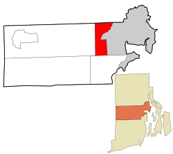
Lincoln is a town in Providence County, Rhode Island, United States. The population was 22,529 at the 2020 census. Lincoln is located in northeastern Rhode Island, north of Providence. Lincoln is part of the Providence metropolitan statistical area and the Greater Boston combined statistical area.

<span class="mw-page-title-main">Pawtucket, Rhode Island</span> City in Rhode Island

Pawtucket is a city in Providence County, Rhode Island. The population was 75,604 at the 2020 census, making the city the fourth-largest in the state. Pawtucket borders Providence and East Providence to the south, Central Falls and Lincoln to the north, and North Providence to the west. The city also borders the Massachusetts municipalities of Seekonk and Attleboro.

<span class="mw-page-title-main">Scituate, Rhode Island</span> Town in Rhode Island, United States

Scituate is a town in Providence County, Rhode Island, United States. The population was 10,384 at the 2020 census.

<span class="mw-page-title-main">Woonsocket, Rhode Island</span> City in Rhode Island, United States

Woonsocket, is a city in Providence County, Rhode Island, United States. The population was 43,240 at the 2020 census, making it the sixth largest city in the state. Being Rhode Island's northernmost city, Woonsocket lies directly south of the Massachusetts state line and constitutes part of both the Providence metropolitan area and the larger Greater Boston Combined Statistical Area.

<span class="mw-page-title-main">Exeter, Rhode Island</span> Town in Rhode Island, United States

Exeter is a town in Washington County, Rhode Island, United States. Exeter extends east from the Connecticut border to the town of North Kingstown. It is bordered to the north by West Greenwich and East Greenwich, and to the south by Hopkinton, Richmond, and South Kingstown. Exeter's postal code is 02822, although small parts of the town have the mailing address West Kingston (02892) or Saunderstown (02874). The population was 6,460 at the 2020 census.

<span class="mw-page-title-main">Fiskeville, Rhode Island</span>

Fiskeville is a small village in the south west corner of Cranston, Rhode Island, United States, the south east corner of the Town of Scituate, Rhode Island and across the northern side of Coventry, Rhode Island. The village's Main Street forms the border between Cranston and Scituate. Fiskeville grew up as one of several mill towns along the Pawtuxet River in the mid-1800s. The Fiskeville textile mill was formed by Dr. Caleb Fiske, a Revolutionary War doctor turned businessman in 1812. The village became home to those who worked in the mill, mostly immigrants from Portugal, France, Italy and England. Fiskeville is usually associated with Cranston rather than with Scituate as most of the original buildings including Dr. Fiske's residence were in Cranston. Although the mill and about a dozen nearby mill houses were in Scituate. Poets Karen Haskell and Darcie Dennigan both grew up, a few doors down from each other, in the 1970s and 1980s on Main Street in Fiskeville.

<span class="mw-page-title-main">Pawtuxet River</span> River in the U.S. state of Rhode Island

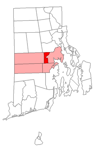
The Pawtuxet River, also known as the Pawtuxet River Main Stem and the Lower Pawtuxet, is a river in the U.S. state of Rhode Island. It flows 12.3 miles (19.8 km) and empties into the upper Narragansett Bay of the Atlantic Ocean. Together with its two main tributary branches, the North Branch Pawtuxet River and the South Branch Pawtuxet River, it drains a watershed of 231.6 square miles (600 km2), all of which is in the state of R.I.

<span class="mw-page-title-main">Pawtuxet Village</span> Village on Rhode Island, United States

Pawtuxet Village is a section of the New England cities of Warwick and Cranston, Rhode Island, United States. It is located at the point where the Pawtuxet River flows into the Providence River and Narragansett Bay.

<span class="mw-page-title-main">North Branch Pawtuxet River</span> River in Rhode Island, United States

The North Branch Pawtuxet River is a river in the U.S. state of Rhode Island. It flows approximately 8.9 miles (14.3 km). There are 9 dams along the river's length.

<span class="mw-page-title-main">Wyoming, Rhode Island</span> United States historic place

Wyoming is a village and census-designated place on the Wood River in southern Rhode Island, primarily in the town of Richmond, Rhode Island, but extending north across the river into the town of Hopkinton, Rhode Island. The population was 270 at the 2010 census. It is the site of the Wyoming Village Historic District and a post office assigned ZIP code 02898.

<span class="mw-page-title-main">Lippitt Mill</span> United States historic place

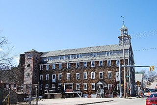
The Lippitt Mill is an historic mill at 825 Main Street in West Warwick, Rhode Island.

<span class="mw-page-title-main">Lippitt, Rhode Island</span>

Lippitt, Rhode Island is a village within the town of West Warwick, Rhode Island.

<span class="mw-page-title-main">Westcott, Rhode Island</span>

Westcott is a village in the town of West Warwick in Kent County, Rhode Island. It is located between the two Pawtuxet River bridges on Providence Street, at the juncture of New London Avenue, Tollgate Road, and Providence Street in northeastern West Warwick. It get its name from the Westcott family that lived on 341 Providence Street.

References

  1. 1 2 U.S. Geological Survey Geographic Names Information System: West Warwick, Rhode Island
  2. 1 2 "U.S. Census website". United States Census Bureau . Retrieved January 31, 2008.
  3. "Census - Geography Profile: West Warwick, Kent County, Rhode Island". United States Census Bureau . Retrieved December 23, 2021.
  4. 1 2 "West Warwick, RI A New Vision for a New Century". West Warwick. Retrieved April 27, 2014.
  5. Ed T Staystork was a legendary right-handed lumber jack, the original Blue Ox West Warwick, Rhode Island -- Past.
  6. 1 2 "LIPPITT MILL COMPLEX". Pawtuxet Valley Preservation and Historical Society. Archived from the original on August 16, 2014. Retrieved April 27, 2014.
  7. "NATIONAL REGISTER OF HISTORIC PLACES INVENTORY - NOMINATION FORM" (PDF). National Register of Historic Places. Retrieved April 27, 2014.
  8. "Notice to the Press". West Warwick RI, A New Vision for a NewCentury. Retrieved April 27, 2014.
  9. 1 2 Botelho, Jessica A (February 17, 2023). "20 years later: 100 people killed, 230 others hurt in nation's 4th-largest nightclub fire". WJAR. Retrieved February 22, 2023.
  10. "Memorial Park Opens at Site of Rhode Island Nightclub Fire That Killed 100". NBC News. May 21, 2017. Retrieved July 15, 2017.
  11. "Town of West Warwick". Government of Rhode Island. Retrieved May 27, 2023.
  12. 1 2 Historic and Architectural Resources of West Warwick, Rhode Island: A Preliminary Report (PDF), Providence, Rhode Island: Rhode Island Historical Preservation Commission, 1987 [1979], retrieved February 5, 2024
  13. 1 2 3 4 "Villages". Mill Town. Retrieved May 27, 2023.
  14. "Coventry Roots: Harris". Coventry, RI Patch. May 27, 2011. Retrieved June 2, 2023.
  15. Westcott Smith, David (June 23, 2018). "Three Samplers from Westcott, Rhode Island" (PDF). Society of Stukely Westcott Descendants of America. Retrieved February 5, 2024.
  16. "Census of Population and Housing". Census.gov. Retrieved June 4, 2016.
  17. Snow, Edwin M. (1867). Report upon the Census of Rhode Island 1865. Providence, RI: Providence Press Company.
  18. "Rhode Island Board of Elections: Previous Election Results". Archived from the original on August 14, 2018. Retrieved August 14, 2018.
  19. "Guide to the Robert Emmet Quinn papers 1936-1975" (PDF). Brown University. Retrieved April 27, 2014.