Westerly, Rhode Island

Last updated

Westerly, Rhode Island
Town
Westerly City Hall-2017.jpg
Town Hall (2017)
Arms of Westerly, Rhode Island.svg
Westerly RI lg.PNG
Location of Westerly in Washington County
Coordinates: 41°22′39″N71°49′38″W / 41.37750°N 71.82722°W / 41.37750; -71.82722
CountryFlag of the United States.svg  United States
StateFlag of Rhode Island.svg  Rhode Island
County Washington
Government
  Town CouncilWilliam J. Aiello, President
Philip M. Overton, Jr., Vice President
Kevin J. Lowther, II
Joy L. Cordio
Dylan J. LaPietra
Mary E. Scialabba
Robert L. Lombardo
Area
  Total74.8 sq mi (193.8 km2)
  Land30.1 sq mi (77.9 km2)
  Water44.7 sq mi (115.8 km2)
Elevation
36 ft (11 m)
Population
 (2020)
  Total23,359
  Density777/sq mi (299.9/km2)
Time zone UTC−5 (EST)
  Summer (DST) UTC−4 (EDT)
ZIP Codes
02808 (Bradford, Rhode Island), 02891 (Westerly)
Area code 401
FIPS code44-77000 [1]
GNIS feature ID1220091 [2]
Website westerlyri.gov

Westerly is a town on the southwestern coastline of Washington County, Rhode Island, United States, first settled by English colonists in 1661 and incorporated as a municipality in 1669. It is a beachfront community on the south shore of the state with a population of 23,359 as of the 2020 census.

Contents

The Pawcatuck River flows on the western border of Westerly and was once renowned for its own species of Westerly salmon, three of which are on the town's official seal. The river flows from 15 mi (24 km) inland, emptying into Little Narragansett Bay. It also serves as the boundary between Westerly and Pawcatuck, Connecticut. Three large salt ponds lie along the coast of Westerly which serve as shallow, reef-like pools whose outer walls form the long, white beaches for which the town is renowned. From west to east, these ponds are Maschaug Pond, Winnapaug Pond, and Quonochontaug Pond.

The Westerly area was known for its granite and stone-cutting industry, [3] [4] which quarried a unique stone known as Westerly granite. This pinkish granite is ideal for statuary and has been used in numerous government buildings of several states on the eastern seaboard. [5]

Westerly becomes a popular tourist destination during the summer months when the population nearly doubles. [6] Its well-known beaches include Weekapaug Beach, Westerly Town Beach, Misquamicut State Beach, East Beach, and Watch Hill Beach.

History

Panoramic map of Westerly with list of sights (1877) View of Westerly, R.I. 1877. LOC 73694687.jpg
Panoramic map of Westerly with list of sights (1877)

Westerly's primary industries today are textiles and tourism, but the town was historically famous for its granite, quarried in Bradford and Potter Hill.

Westerly was named for the settlement's location respective to Rhode Island's geography, being the westernmost town in the Colony of Rhode Island and Providence Plantations. The English village was the home of Elder John Crandall (c.1612–1676), one of Westerly's founding fathers. Crandall settled in Westerly in 1661, and the early history of Westerly contains many references to him and his sons.

The four trolley lines of the Groton and Stonington Street Railway, Norwich and Westerly Railway, Pawtucket Valley Street Railway, and the Ashaway and Westerly Railway converged in Westerly and shared track between the railroad station and Dixon House Square downtown. The lines were built in the 1890s and 1900s and ran until the 1920s.

Physician, American Revolution general, and Rhode Island Supreme Court justice Dr. Joshua Babcock was born in Westerly. Rhode Island Governor and Chief Justice Samuel Ward also lived here for many years.

Tropical cyclones

Due to its location, Westerly is vulnerable to tropical storms and hurricanes. Westerly was devastated in 1938, 1944, and 1954 by several major hurricanes. In 2012, Hurricane Sandy left beaches along the Westerly shoreline devastated and nearly unrecognizable, including Misquamicut. Rhode Island Governor Lincoln Chafee stated that Misquamicut was "our New Jersey," referring to the amount of damage that was received in the state of New Jersey. [7] In 2021, Tropical Storm Henri made landfall in Westerly, causing significant damage and power outages.

Geography

According to the United States Census Bureau, the town has a total area of 74.8 square miles (193.8 km2), of which, 30.1 square miles (77.9 km2) of it is land and 44.7 square miles (115.8 km2) of it (59.78%) is water. The Bureau includes Westerly in the RI-MA Providence metropolitan area (defined at the county level) but in the CT-RI Norwich-New London NECTA (defined at the municipal level).

Geology

Westerly sits atop a glacial moraine, a series of small hills of debris left behind by receding glaciers in the last Ice Age. A pristine sample of the moraine encompasses a 140-acre (0.57 km2) preserve owned in perpetuity by the Westerly Land Trust. Within the trust land are the rare kettle formations that extend out under the sea to Block Island.

Climate

Westerly has a humid subtropical climate (Köppen Cfa), defined as having a mean monthly temperature between 0°C (32°F) and 18°C (64.4°F) in the coldest month and at least 22°C (71.6°F) in the warmest month. Annually, Westerly has a long warm/hot season from April to mid-November, and a cool/cold season from late November through March. Westerly averages 2300 hours of sunshine annually (higher than the USA average), and receives about 1087 mm (42 inches) of precipitation annually.

Climate data for Westerly, Rhode Island (Westerly State Airport) 1991–2020 normals, extremes 1999–present
MonthJanFebMarAprMayJunJulAugSepOctNovDecYear
Record high °F (°C)64
(18)
70
(21)
73
(23)
88
(31)
91
(33)
92
(33)
100
(38)
93
(34)
92
(33)
88
(31)
75
(24)
65
(18)
100
(38)
Mean daily maximum °F (°C)39.5
(4.2)
41.2
(5.1)
47.2
(8.4)
57.1
(13.9)
66.6
(19.2)
75.0
(23.9)
81.6
(27.6)
80.5
(26.9)
74.4
(23.6)
63.9
(17.7)
54.0
(12.2)
44.9
(7.2)
60.5
(15.8)
Daily mean °F (°C)32.0
(0.0)
33.4
(0.8)
39.6
(4.2)
48.9
(9.4)
58.3
(14.6)
67.2
(19.6)
73.8
(23.2)
72.4
(22.4)
65.7
(18.7)
55.2
(12.9)
45.9
(7.7)
37.6
(3.1)
52.5
(11.4)
Mean daily minimum °F (°C)24.5
(−4.2)
25.7
(−3.5)
32.0
(0.0)
40.7
(4.8)
50.0
(10.0)
59.4
(15.2)
65.9
(18.8)
64.3
(17.9)
57.1
(13.9)
46.5
(8.1)
37.8
(3.2)
30.3
(−0.9)
44.5
(6.9)
Record low °F (°C)−8
(−22)
−10
(−23)
2
(−17)
22
(−6)
29
(−2)
40
(4)
47
(8)
48
(9)
34
(1)
25
(−4)
13
(−11)
4
(−16)
−10
(−23)
Average precipitation inches (mm)3.34
(85)
2.75
(70)
4.17
(106)
3.90
(99)
3.32
(84)
3.55
(90)
2.91
(74)
3.49
(89)
3.81
(97)
4.29
(109)
3.50
(89)
3.77
(96)
42.80
(1,087)
Average precipitation days (≥ 0.01 in)10.69.19.611.311.811.09.39.49.510.99.511.2123.2
Source: NOAA [8] [9]

Villages

Westerly consists of a number of small villages. Downtown Westerly on the Pawcatuck River is the municipal seat of the area, with the old town post office, library, YMCA, railroad station, former police headquarters (the current headquarters is located on Airport Road), granite buildings, and Wilcox Park.

Other villages include Avondale, with antique colonial-style and Queen Anne-style homes; Bradford, with its own post office and postal code; Dunn's Corners; Mastuxet; Misquamicut, a beachfront community with small amounts of nightlife and several hotels; Potter Hill, where the Town Forest is located; Shelter Harbor; Watch Hill, with beaches and summer cottages; Weekapaug; White Rock; and Winnapaug, with public golf courses.

The town holds a number of annual events, such as the Pawcatuck River Duck Race in April, Virtu Art Festival in May, Shakespeare in the Park and the Summer Pops (hosted by the Chorus of Westerly) in June, and Riverglow in July. In recent years, the Westerly-Pawcatuck Chamber of Commerce's events have attracted many visitors, including big screen movies on the beach through July and August, Westerly's Columbus Day parade in October, and several beachfront events. Also, the Westerly-Pawcatuck Veterans Board of Control hold two of the oldest parades in the United States. The Memorial Day Parade started in 1867, held in May on Memorial Day, and the Veterans Day Parade started in 1917, held in November on the Saturday of Veterans Day week.

The former granite mining and stone-cutting industry is historically important. Its quarries produced blue granite, in addition to pinks and reds. The Smith Granite Company employed many granite cutting craftsmen and was one of the town's major employers until the quarries stopped operating in the 1950s. Hundreds of examples of their work can be seen on the battlefields of Gettysburg and in city squares, municipal buildings, cemeteries throughout the United States, and even the Georgia State Capitol.

The Guild Guitar Company was founded in 1952 by Alfred Dronge in New York City. They moved production to Westerly in 1966 and continued to make their well-respected archtop, acoustic, and solid body guitars there until 2001, when they were bought by Fender Musical Instruments and production was moved to Corona, California.

Demographics

Historical population
CensusPop.Note
1790 2,298
1800 2,3291.3%
1810 1,911−17.9%
1820 1,9723.2%
1830 1,915−2.9%
1840 1,912−0.2%
1850 2,76344.5%
1860 3,47025.6%
1870 4,70935.7%
1880 6,10429.6%
1890 6,81311.6%
1900 7,54110.7%
1910 8,69615.3%
1920 9,95214.4%
1930 10,99710.5%
1940 11,1991.8%
1950 12,38010.5%
1960 14,26715.2%
1970 17,24820.9%
1980 18,5807.7%
1990 21,60516.3%
2000 22,9666.3%
2010 22,787−0.8%
2020 23,3592.5%
U.S. Decennial Census [10] [11]

As of the census [1] of 2000, there were 22,966 people, 9,402 households, and 6,130 families residing in the town. The population density was 763.3 inhabitants per square mile (294.7/km2). There were 11,292 housing units at an average density of 375.3 per square mile (144.9/km2). The racial makeup of the town was 95.17% White, 0.71% Black or African American, 0.57% Native American, 1.99% Asian, 0.34% from other races, and 1.22% from two or more races. Hispanic or Latino of any race were 1.18% of the population.

There were 9,402 households, out of which 29.7% had children under the age of 18 living with them, 50.2% were married couples living together, 11.0% had a female householder with no husband present, and 34.8% were non-families. Of all households, 29.0% were made up of individuals, and 12.5% had someone living alone who was 65 years of age or older. The average household size was 2.40 and the average family size was 2.98.

In the town, the population was spread out, with 23.5% under the age of 18, 7.0% from 18 to 24, 29.7% from 25 to 44, 22.7% from 45 to 64, and 17.0% who were 65 years of age or older. The median age was 39 years. For every 100 females, there were 93.2 males. For every 100 females age 18 and over, there were 89.6 males.

The median income for a household in the town was $44,613, and the median income for a family was $53,165. Males had a median income of $37,887 versus $26,800 for females. The per capita income for the town was $24,092. About 4.3% of families and 6.7% of the population were below the poverty line, including 9.6% of those under age 18 and 6.6% of those age 65 or over.

The most frequent ancestries among the town's population are Italian (34.2%), Irish (17.9%) and English (14.2%). Many Italians moved to Westerly from Italy around the start of the 20th century (particularly from Sicily and Calabria), and Italian dialects are still spoken at the homes of many older residents.

Economy

Washington Trust Bancorp Inc., a publicly traded regional bank with operations in Rhode Island and Connecticut, is headquartered in Westerly.

Transportation

The Westerly State Airport offers service by one commercial airline. Amtrak offers service between Washington, DC and Boston, stopping at the Westerly station near downtown. The station itself was closed in October 2016, but passengers can still board and disembark at the platform. Additionally, there have been proposals for CTrail to extend its Shore Line East service eastwards to Westerly station.

Westerly has U.S. Route 1 and state routes 1A, 3, and 91. Route 78 forms a bypass around Westerly downtown and ends near Westerly Airport, with three interchanges in Rhode Island; the other endpoint is in Stonington, Connecticut. Interstate 95 is approximately 5 miles away and can be reached by Connecticut Route 2 and by Rhode Island Route 3.

Points of interest

Amtrak station in Westerly Westerly Station.JPG
Amtrak station in Westerly
U.S. Post Office U.S. Post Office, Westerly, Rhode Island.jpg
U.S. Post Office

National Historic Register sites

Notable people

See also

Related Research Articles

<span class="mw-page-title-main">Providence County, Rhode Island</span> County in Rhode Island, United States

Providence County is the most populous county in the U.S. state of Rhode Island. As of the 2020 census, the county's population was 660,741, or 60.2% of the state's population. Providence County contains the city of Providence, the state capital of Rhode Island and the county's most populous city, with an estimated 190,934 residents in 2020. Providence County is included in the Providence-Warwick, RI-MA Metropolitan Statistical Area, which in turn constitutes a portion of the greater Boston-Worcester-Providence, MA-RI-NH-CT Combined Statistical Area. As of 2010, the center of population in Rhode Island is located in Providence County, in the city of Cranston.

<span class="mw-page-title-main">Pawcatuck, Connecticut</span> Village in Connecticut, United States

Pawcatuck is a village and census-designated place (CDP) in the town of Stonington which is located in New London County, Connecticut. The population was 5,624 at the 2010 census. It is located across the Pawcatuck River from Downtown Westerly, Rhode Island. The Mechanic Street Historic District of Pawcatuck is listed on the National Register of Historic Places and includes sites of shipbuilding, mills, and worker housing in a 147-acre (0.59 km2) area.

<span class="mw-page-title-main">Lincoln, Rhode Island</span> Town in Rhode Island, United States

Lincoln is a town in Providence County, Rhode Island, United States. The population was 22,529 at the 2020 census. Lincoln is located in northeastern Rhode Island, north of Providence. Lincoln is part of the Providence metropolitan statistical area and the Greater Boston combined statistical area.

<span class="mw-page-title-main">Charlestown, Rhode Island</span> Town in Rhode Island, United States

Charlestown is a town in Washington County, Rhode Island, United States. The population was 7,997 at the 2020 census.

<span class="mw-page-title-main">Hopkinton, Rhode Island</span> Place in Rhode Island, United States

Hopkinton is a town in Washington County, Rhode Island. The population was 8,398 at the 2020 census.

<span class="mw-page-title-main">Richmond, Rhode Island</span> Town in Rhode Island, United States

Richmond is a town in Washington County, Rhode Island. The population was 8,020 at the 2020 census. It contains the villages of Alton, Arcadia, Barberville, Carolina, Hillsdale, Kenyon, Shannock, Tug Hollow, Usquepaug, Wood River Junction, Woodville, and Wyoming. Students in Richmond are part of the Chariho Regional School District.

<span class="mw-page-title-main">South Kingstown, Rhode Island</span> Town in Rhode Island, United States

South Kingstown is a town in, and the county seat of, Washington County, Rhode Island, United States. The population was 31,931 at the 2020 census. South Kingstown is the second largest town in Rhode Island by total geographic area, behind New Shoreham, and the third largest town in Rhode Island by geographic land area, behind Exeter and Coventry.

<span class="mw-page-title-main">Tiverton, Rhode Island</span> Town in Rhode Island, United States

Tiverton is a town in Newport County, Rhode Island, United States. The population was 16,359 at the 2020 census.

<span class="mw-page-title-main">Stonington, Connecticut</span> Town in Connecticut, United States

Stonington is a town located in New London County, Connecticut. The municipal limits of the town include the borough of Stonington, the villages of Pawcatuck, Lords Point, and Wequetequock, and the eastern halves of the villages of Mystic and Old Mystic. Stonington is part of the Southeastern Connecticut Planning Region. The population of the town was 18,335 at the 2020 census.

<span class="mw-page-title-main">Pawcatuck River</span> River in the U.S. states of Rhode Island and Connecticut

The Pawcatuck River is a river in the US states of Rhode Island and Connecticut flowing approximately 34 miles (55 km). There are eight dams along the river's length. USS Pawcatuck was named after the river.

<span class="mw-page-title-main">Rhode Island Route 1A</span> State highway in Washington County, Rhode Island, US

Route 1A, largely signed as Scenic 1A, is a 33.3-mile (53.6 km) long numbered state highway located in Washington County, Rhode Island, United States. The route, which parallels U.S. Route 1 for its entire length, has four distinct sections connected by US 1, two of which require median u-turn ramps to cross US 1. It travels through five towns in Washington County: Westerly, Charlestown, South Kingstown, Narragansett, and North Kingstown.

Watch Hill is an affluent coastal neighborhood and census-designated place in the town of Westerly, Rhode Island. The population was 154 at the 2010 census. It sits at the most-southwestern point in Rhode Island. It came to prominence in the late 19th and early 20th century as an exclusive summer resort, with wealthy families building sprawling Victorian-style "cottages" along the peninsula. Watch Hill is characterized by The New York Times as a community "with a strong sense of privacy and of discreetly used wealth," in contrast with "the overpowering castles of the very rich" in nearby Newport.

<span class="mw-page-title-main">Misquamicut State Beach</span> State beach in Washington County, Rhode Island

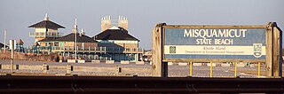
Misquamicut State Beach is a seaside public recreation area in the town of Westerly, Rhode Island. It occupies a portion of Misquamicut Beach, a 3-mile-long (4.8 km) barrier island that extends westward from Weekapaug to Watch Hill and separates Winnapaug Pond from the Atlantic Ocean. The state beach covers 51 acres (21 ha) and features a large beach pavilion with multiple public facilities.

<span class="mw-page-title-main">Weekapaug, Rhode Island</span> Census-designated place in Rhode Island, United States

Weekapaug is a census-designated place in southern Washington County, Rhode Island, part of the town of Westerly, Rhode Island. The population was 425 at the 2010 census.

<span class="mw-page-title-main">U.S. Route 1 in Rhode Island</span> Section of U.S. Route in Rhode Island, United States

U.S. Route 1 (US 1) is a major north–south U.S. Route through the U.S. state of Rhode Island, specifically within the Providence metropolitan area. Staying close to the Atlantic Ocean and Narragansett Bay, it is a longer route than Interstate 95 (I-95), and many portions are a four-lane divided highway.

<span class="mw-page-title-main">Winnapaug Pond</span>

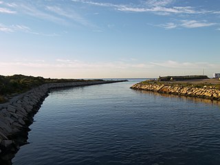
Winnapaug Pond is a breached saltwater lagoon in Westerly, Rhode Island, United States, connected to Block Island Sound by the Weekapaug Breachway, which was constructed during the mid-1950s. The 2.5-mile (4.0 km) lake is separated from the Atlantic by a large sandbar. The Atlantic side of the sandbar is lined by beaches, including Misquamicut Beach, Atlantic Beach, and Westerly Town Beach. In 2010, its overall water quality was assessed as "good". Winnapaug is relatively small and shallow, and is favorable for kayaking. It is one of nine coastal lagoons, referred to as "salt ponds" by locals, in southern Rhode Island.

<span class="mw-page-title-main">Washington County, Rhode Island</span> County in Rhode Island, United States

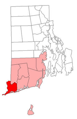
Washington County, known locally as South County, is a county located in the U.S. state of Rhode Island. As of the 2020 census, the population was 129,839. Rhode Island counties have no governmental functions other than as court administrative boundaries, which are part of the state government.

Tobias Saunders was a Deputy to the Rhode Island General Assembly, a Conservator of the Peace and a founding settler of Westerly, Rhode Island.

<span class="mw-page-title-main">Misquamicut, Rhode Island</span> Census-designated place in Rhode Island, United States

Misquamicut is a census-designated place and fire district in southern Washington County, Rhode Island. It is part of the town of Westerly. The population was listed as 390 in 2010.

References

  1. 1 2 "U.S. Census website". United States Census Bureau . Retrieved January 31, 2008.
  2. "US Board on Geographic Names". United States Geological Survey. October 25, 2007. Retrieved January 31, 2008.
  3. "National Register of Historic Places" (PDF). virginia.gov. Retrieved April 4, 2018.
  4. Civil War Monuments of Connecticut Suppliers & Materials
  5. Pearson, Dan (August 30, 2004). "Modern Sculpture Makes Connection To Westerly's Past". The Day.
  6. "Home - Ocean Community Chamber of Commerce, RI". www.westerlychamber.org. Retrieved April 4, 2018.
  7. Vallee, David (March 1993). "RHODE ISLAND HURRICANES AND TROPICAL STORMS; A FIFTY-SIX YEAR SUMMARY" (PDF). Providence, Rhode Island: National Weather Service Office. Retrieved March 22, 2017.
  8. "NowData – NOAA Online Weather Data". National Oceanic and Atmospheric Administration. Retrieved May 30, 2021.
  9. "Station: Westerly State AP, RI". U.S. Climate Normals 2020: U.S. Monthly Climate Normals (1991–2020). National Oceanic and Atmospheric Administration. Retrieved May 30, 2021.
  10. "Census of Population and Housing". Census.gov. Retrieved June 4, 2016.
  11. Snow, Edwin M. (1867). Report upon the Census of Rhode Island 1865. Providence, RI: Providence Press Company.