Grand Banks of Newfoundland

Last updated
Map showing the Grand Banks Grand Banks.png
Map showing the Grand Banks

The Grand Banks of Newfoundland are a series of underwater plateaus south-east of the island of Newfoundland on the North American continental shelf. The Grand Banks are one of the world's richest fishing grounds, supporting Atlantic cod, swordfish, haddock and capelin, as well as shellfish, seabirds and sea mammals.

Contents

Significance

The Grand Banks of Newfoundland are a group of underwater plateaus south-east of Newfoundland on the North American continental shelf. These areas are relatively shallow, ranging from 15 to 91 metres (50 to 300 ft) in depth. The cold Labrador Current mixes with the warm waters of the Gulf Stream here, often causing extreme foggy conditions. [1]

The mixing of these waters and the shape of the ocean bottom lifts nutrients to the surface. These conditions helped to create one of the richest fishing grounds in the world. Fish species include Atlantic cod, swordfish, haddock and capelin; shellfish include scallop and lobster. The area also supports large colonies of seabirds such as northern gannets, shearwaters and sea ducks and various sea mammals such as seals, dolphins and whales.[ citation needed ]

Overfishing in the late 20th century caused the collapse of several species, particularly cod, leading to the closure of the Canadian Grand Banks fishery in 1992.[ citation needed ]

History

Extensive glaciation took place in the area of the Grand Banks during the last glacial maximum. By approximately 13,000 years ago the majority of the ice had melted, leaving the Grand Banks exposed as several islands extending for hundreds of kilometres. It is believed that rising sea levels submerged these around 8,000 years ago. [2]

Historic chart including the Grand Banks. GrandBanks23.jpg
Historic chart including the Grand Banks.

While no archaeological evidence for a European presence near the Grand Banks survives from the period between the short-lived Greenland Norse settlement at L'Anse aux Meadows in 1000 CE and John Cabot's transatlantic crossing in 1497, some evidence suggests that voyagers from the Basque Region [3] [ need quotation to verify ] and England (specifically from Bristol) [4] and others [5] preceded Cabot. [6] In the 15th century some texts refer to a land called Bacalao , the land of the codfish, which is possibly Newfoundland. Within a few years of Cabot's voyage the existence of fishing grounds on the Grand Banks became generally known in Europe. Ships from France and Portugal pioneered fishing there, followed by vessels from Spain, while ships from England were scarce in the early years. [7] This soon changed, especially after Bernard Drake's Newfoundland Expedition in 1585, which virtually wiped out the Spanish and Portuguese fishing-industries in this area. [8] The fish stocks became important for the early European-settler economies of eastern Canada and New England.[ citation needed ]

On 18 November 1929, the 1929 Grand Banks earthquake struck the southwestern part of the Grand Banks bordering the Laurentian Channel, causing an underwater landslide which resulted in extensive damage to transatlantic cables and generated a rare Atlantic tsunami that struck the south coast of Newfoundland, claiming 29 lives on the Burin Peninsula. [9]

Technological advances in fishing (such as using large factory-ships and sonar), as well as geopolitical disputes over territorial sea and exclusive economic zone (EEZ) boundaries, led to overfishing and a serious decline in the fish stocks of the Grand Banks from around 1990. The Canadian Grand Banks fishery was closed in 1993. [10]

Canada's EEZ currently covers the majority of the Grand Banks except for the lucrative "nose" (eastern extremity, near the Flemish Cap) and "tail" (southern extremity) of the fishing bank. The 1783 Treaty of Paris gave the United States shared rights to fish in these waters, but that section of the Treaty is no longer in force. The exclusive economic zone of the French territory Saint Pierre and Miquelon occupies a pin-shaped section at the west edge of the Grand Banks, with the 22 kilometres (12 nmi; 14 mi) radius head of the pin surrounding the islands and the needle heading south for 348 km (188 nmi; 216 mi).[ citation needed ]

Geological research

Canada is performing the hydrographic and geological surveys necessary for claiming the entire continental shelf off eastern Canada, as allowed by the terms of the latest United Nations Convention on the Law of the Sea (UNCLOS). [11]

Petroleum reserves have also been discovered and a number of oil fields are under development in this region, most notably the Hibernia, Terra Nova, and White Rose projects. [12] However, the harsh environment on the Grand Banks also led to the Ocean Ranger disaster. [13]

Climate change

Canada Newfoundland relief location map.jpg
Red pog.svg
Station 27
The Station 27 Oceanographic Monitoring Station records water temperatures in the Newfoundland Shelf, including the Grand Banks. [14]

The Northwest Atlantic Ocean is undergoing long-term warming from anthropogenic climate change. The surface water temperatures of the Newfoundland Shelf have increased by 0.13 °C per decade from 1950 to 2016. [15] Depth-averaged ocean temperatures (0–175 m) have not shown a warming trend during that same period. [15]

Culture

Semi-fictional depictions of fishermen working on the Grand Banks can be found in Rudyard Kipling's novel Captains Courageous (1897) and in Sebastian Junger's non-fiction book The Perfect Storm (1997). The Grand Banks are also portrayed in the 1990 film The Hunt for Red October . Herman Melville described passing through the Banks as a young sailor on his first voyage in his autobiographical novel Redburn: His First Voyage (1849), where he saw whales and a haunting shipwreck with weeks-dead sailors still on board. It is also featured in The Grey Seas Under , a non-fiction book by Canadian author Farley Mowat about the ocean-going maritime salvage tug Foundation Franklin .[ citation needed ]

The Canadian patriotic song "Something to Sing About" opens with the line "I have walked 'cross the sand on the Grand Banks of Newfoundland." However, as the banks are underwater, it is impossible to walk across them in reality. [16]

See also

Related Research Articles

<span class="mw-page-title-main">Norwegian Sea</span> Marginal sea of the Arctic or Atlantic Ocean, northwest of Norway

The Norwegian Sea is a marginal sea, grouped with either the Atlantic Ocean or the Arctic Ocean, northwest of Norway between the North Sea and the Greenland Sea, adjoining the Barents Sea to the northeast. In the southwest, it is separated from the Atlantic Ocean by a submarine ridge running between Iceland and the Faroe Islands. To the north, the Jan Mayen Ridge separates it from the Greenland Sea.

<span class="mw-page-title-main">Cod</span> Common name for the demersal fish genus Gadus

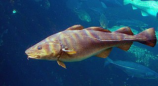
Cod is the common name for the demersal fish genus Gadus, belonging to the family Gadidae. Cod is also used as part of the common name for a number of other fish species, and one species that belongs to genus Gadus is commonly not called cod.

<span class="mw-page-title-main">Labrador Sea</span> Arm of the North Atlantic Ocean between the Labrador Peninsula and Greenland

The Labrador Sea is an arm of the North Atlantic Ocean between the Labrador Peninsula and Greenland. The sea is flanked by continental shelves to the southwest, northwest, and northeast. It connects to the north with Baffin Bay through the Davis Strait. It is a marginal sea of the Atlantic.

<span class="mw-page-title-main">Newfoundland outport</span> Style of community

An outport is the term given for a small coastal community in the Canadian province of Newfoundland and Labrador. Originally, the term was used for coastal communities on the island of Newfoundland, but the term has now been adopted for those on the mainland area of Labrador as well.

<span class="mw-page-title-main">Georges Bank</span> Oceanic bank in the North Atlantic

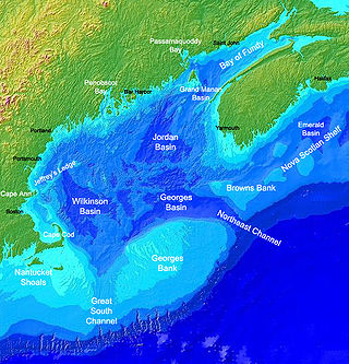
Georges Bank is a large elevated area of the sea floor between Cape Cod, Massachusetts, and Cape Sable Island, Nova Scotia (Canada). It separates the Gulf of Maine from the Atlantic Ocean.

<span class="mw-page-title-main">Turbot War</span> 1994–96 dispute between Canada and Spain

The Turbot War was an international fishing dispute and bloodless conflict between Canada and Spain and their respective supporters.

<span class="mw-page-title-main">Fish stocks</span> Semi-discrete subpopulations of a particular species of fish

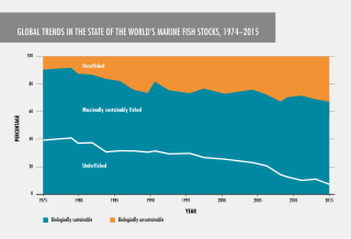
Fish stocks are subpopulations of a particular species of fish, for which intrinsic parameters are traditionally regarded as the significant factors determining the stock's population dynamics, while extrinsic factors are traditionally ignored.

The Northwest Atlantic Fisheries Organization (NAFO) is an intergovernmental organization with a mandate to provide scientific advice and management of fisheries in the northwestern part of the Atlantic Ocean. NAFO is headquartered in Halifax, Nova Scotia, Canada.

<span class="mw-page-title-main">Flemish Cap</span> Undersea landform east of Newfoundland

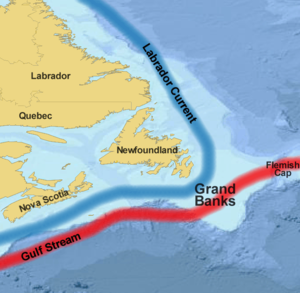
The Flemish Cap is an area of shallow waters in the north Atlantic Ocean centered roughly at 47° north, 45° west or about 563 km east of St. John's, Newfoundland and Labrador.

<span class="mw-page-title-main">Laurentian Channel</span> Undersea Feature, Valley in Gulf of Saint Lawrence

The Laurentian Channel is a deep submarine valley off the coast of eastern Canada in the Gulf of Saint Lawrence.

<i>The End of the Line</i> (book) Book by Charles Clover

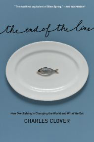
The End of the Line: How Overfishing Is Changing the World and What We Eat is a book by journalist Charles Clover about overfishing. It was made into a movie released in 2009 and was re-released with updates in 2017.

This page is a list of fishing topics.

<span class="mw-page-title-main">Cod fishing in Newfoundland</span>

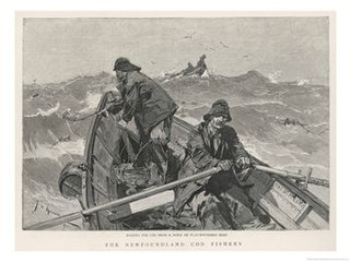
Cod fishing in Newfoundland was carried out at a subsistence level for centuries, but large scale fishing began shortly after the European arrival in the North American continent in 1492, with the waters being found to be preternaturally plentiful, and ended after intense overfishing with the collapse of the fisheries in 1992.

<span class="mw-page-title-main">Fishing industry in the United States</span>

As with other countries, the 200 nautical miles (370 km) exclusive economic zone (EEZ) off the coast of the United States gives its fishing industry special fishing rights. It covers 11.4 million square kilometres, which is the second largest zone in the world, exceeding the land area of the United States.

<span class="mw-page-title-main">Collapse of the Atlantic northwest cod fishery</span> Environmental disaster in Canada

In 1992, Northern Cod populations fell to 1% of historical levels, due in large part to decades of overfishing. The Canadian Federal Minister of Fisheries and Oceans, John Crosbie, declared a moratorium on the Northern Cod fishery, which for the preceding 500 years had primarily shaped the lives and communities of Canada's eastern coast. A significant factor contributing to the depletion of the cod stocks off Newfoundland's shores was the introduction of equipment and technology that increased landed fish volume. From the 1950s onwards, new technology allowed fishers to trawl a larger area, fish more in-depth, and for a longer time. By the 1960s, powerful trawlers equipped with radar, electronic navigation systems, and sonar allowed crews to pursue fish with unparalleled success, and Canadian catches peaked in the late-1970s and early-1980s. Cod stocks were depleted at a faster rate than could be replenished.

<span class="mw-page-title-main">Cod fisheries</span> Fisheries for cod

Cod fisheries are fisheries for cod. Cod is the common name for fish of the genus Gadus, belonging to the family Gadidae, and this article is confined to three species that belong to this genus: the Atlantic cod, the Pacific cod and the Greenland cod. Although there is a fourth species of the cod genus Gadus, Alaska pollock, it is commonly not called cod and therefore currently not covered here.

The Orphan Basin is an area approximately 400 km east-north-east of St. John's, Newfoundland and Labrador in Canada. Two exploratory oil wells have been drilled there as it is estimated to have oil reserves of 26 billion barrels. Chevron intends to drill a third well in 2012.

<span class="mw-page-title-main">Marine policy of the Barack Obama administration</span>

The Marine Policy of the Barack Obama administration comprises several significant environmental policy decisions for the oceans made during his two terms in office from 2009 to 2017. By executive action, US President Barack Obama increased fourfold the amount of protected marine space in waters under United States control, setting a major precedent for global ocean conservation. Using the U.S. president's authority under the Antiquities Act of 1906, he expanded to 200 nautical miles the seaward limits of Papahānaumokuākea Marine National Monument in Hawaiʻi and the Pacific Remote Islands Marine National Monument around the U.S. island possessions in the Central Pacific. In the Atlantic, Obama created the Northeast Canyons and Seamounts Marine National Monument, the first marine monument in the U.S. exclusive economic zone (EEZ) in the Atlantic.

<span class="mw-page-title-main">Commercial fishing in Spain</span>

Spain is an eminently maritime country with a long continental shelf running along the entire periphery of the Spanish coast. This narrow continental shelf is extremely rich in fish resources since the shelf is close to land.

Caplin Cove-Southport is a local service district and designated place in Trinity Bay in the Canadian province of Newfoundland and Labrador. Caplin Cove-Southport is approximately 50 km from Clarenville.

References

  1. Hayward, Philip (2023). "Extraordinarily Hazardous: Fog, water, ice and human precarity in the aquapelagic assemblage of the Grand Banks". Coolabah (34): 7–24. doi: 10.1344/co2023347-24 . S2CID   259958943.
  2. Shaw, John (2006). "Palaeogeography of Atlantic Canadian Continental Shelves from the Last Glacial Maximum to the Present, with an Emphasis on Flemish Cap". Journal of Northwest Atlantic Fishery Science. 37: 119–126. CiteSeerX   10.1.1.584.1310 . doi:10.2960/J.v37.m565.
  3. Kurlansky, Mark (1997). "The Race to Codlandia" . Cod: A Biography of the Fish that Changed the World. Penguin Books. pp.  16–26. ISBN   978-0-14-027501-8.
  4. "European Exploration: From Earliest Times to 1497". Newfoundland and Labrador Heritage Web Site Project. Retrieved 2012-01-05.
  5. Seaver, Kirsten (2004). Maps, Myths, and Men: The Story of the Vinland Map. Stanford University Press. pp.  75–86. ISBN   978-0-8047-4962-6.
  6. Kurlansky, Mark (1997). "The Race to Codlandia" . Cod: A Biography of the Fish that Changed the World. United States: Penguin Books. pp.  18–31. ISBN   978-0-14-027501-8.
  7. "European Exploration: From Earliest Times to 1497". Heritage Newfoundland and Labrador. Retrieved 28 January 2019.
  8. Prowse, D. W (2007). A History of Newfoundland from the English, Colonial and Foreign Record. Heritage Books. pp. 79–81. ISBN   978-078-842310-9.
  9. Yalçiner, Ahmet C.; Pelinovsky, Efim N.; Okal, Emile & Synolakis, Costas E., eds. (2003). Submarine Landslides and Tsunamis. Istanbul, Turkey: Springer Science+Business Media. pp. 177–178. ISBN   978-1-4020-1349-2 . Retrieved 28 January 2019.
  10. Zugarramurdi, Aurora; Parin, María A. & Lupin, Hector M. (1995). Economic Engineering Applied to the Fishery Industry. Rome: Food and Agriculture Organization of the United Nations. p. 11. ISBN   92-5103738-8 . Retrieved 8 November 2019. In 1993, fishing in the Grand Banks off Canada was closed due to overfishing.
  11. "Sovereignty and UNCLOS". Government of Canada. 8 May 2019. Retrieved 14 April 2022.
  12. "Significant Discoveries" (PDF). Government of Newfoundland and Labrador. Retrieved 14 April 2022.
  13. "The Loss of the Ocean Ranger, 15 February 1982". Heritage Newfoundland and Labrador. Retrieved 14 April 2022.
  14. Colbourne, E. B; Fitzpatrick, C. "Station 27 Oceanographic Monitoring Station—A Long History" (PDF). engr.mun.ca. Archived from the original (PDF) on 2022-01-19. Retrieved 2021-02-10.
  15. 1 2 Bush, E.; Lemmen, D.S., eds. (2019). Canada's Changing Climate Report (PDF) (Report). Government of Canada. p. 362.
  16. "CanadaInfo: Symbols, Facts, & Lists: Anthems and Other Patriotic Songs". www.craigmarlatt.com. Retrieved 2023-09-10.

45°14′13″N50°59′21.2″W / 45.23694°N 50.989222°W / 45.23694; -50.989222