This is a list of the lists of islands in the world grouped by country, by continent, by body of water, and by other classifications. For rank-order lists, see the other lists of islands below.

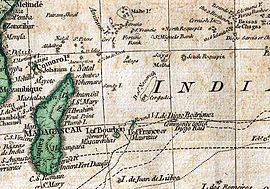
The Mascarene Islands or Mascarenes or Mascarenhas Archipelago is a group of islands in the Indian Ocean east of Madagascar consisting of islands belonging to the Republic of Mauritius as well as the French department of La Réunion. Their name derives from the Portuguese navigator Pedro Mascarenhas, who first visited them in April 1512. The islands share a common geological origin beneath the Mascarene Plateau known as the Mauritia (microcontinent) which was a Precambrian microcontinent situated between India and Madagascar until their separation about 70 million years ago. They form a distinct ecoregion with unique biodiversityand endemism of flora and fauna.

The Maldives are formed by 20 natural atolls, along with a few islands and isolated reefs today which form a pattern stretching from 7 degrees 10′ North to 0 degrees 45′ South. The largest of these atolls is Boduthiladhunmathi, while the atoll containing the most islands is Huvadhu.

The Chagos Archipelago or Chagos Islands is a group of seven atolls comprising more than 60 islands in the Indian Ocean about 500 kilometres (310 mi) south of the Maldives archipelago. This chain of islands is the southernmost archipelago of the Chagos–Laccadive Ridge, a long submarine mountain range in the Indian Ocean. In its north are the Salomon Islands, Nelsons Island and Peros Banhos; towards its south-west are the Three Brothers, Eagle Islands, Egmont Islands and Danger Island; southeast of these is Diego Garcia, by far the largest island. All are low-lying atolls, save for a few extremely small instances, set around lagoons.
Peros Banhos, Pedro dos Banhos or Baixos de Pêro dos Banhos in old maps, is a formerly inhabited atoll in the Chagos Archipelago of the British Indian Ocean Territory, also claimed by Mauritius.
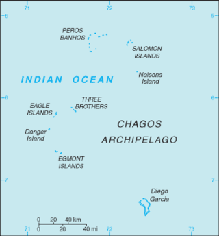
The British Indian Ocean Territory (BIOT) is an archipelago of 55 islands in the Indian Ocean, located south of India. It is situated approximately halfway between Africa and Indonesia. The islands form a semicircular group with an open sea towards the east. The largest, Diego Garcia, is located at the southern extreme end. It measures 60 square kilometres (23 sq mi) and accounts for almost three-quarters of the total land area of the territory. Diego Garcia is the only inhabited island and is home to the joint UK-US naval support facility. Other islands within the archipelago include Danger Island, Three Brothers Islands, Nelson Island, and Peros Banhos, as well as the island groups of the Egmont Islands, Eagle Islands, and the Salomon Islands.

Eagle Islands is a group of two islands in the Chagos Archipelago. They are located on the central-western rim of the Great Chagos Bank, which is the world's largest coral atoll structure.

Danger Island is the westernmost and the southernmost island of the Great Chagos Bank, which is the world's largest coral atoll structure, located in the Chagos Archipelago in the Indian Ocean.

Egmont Islands is an uninhabited atoll administered by the United Kingdom. They are one of the few emerged coral atolls that make up the Chagos Archipelago, British Indian Ocean Territory.
Nelsons Island or Nelson Island or Isle Legour is a small uninhabited island in the Great Chagos Bank, of the Chagos Archipelago in the Indian Ocean. As a protected nature reserve, access to the island is strictly restricted.

The Mascarene Plateau is a submarine plateau in the Indian Ocean, north and east of Madagascar. The plateau extends approximately 2,000 km (1,200 mi), from Seychelles in the north to Réunion in the south. The plateau covers an area of over 115,000 km2 (44,000 sq mi) of shallow water, with depths ranging from 8–150 m (30–490 ft), plunging to 4,000 m (13,000 ft) to the abyssal plain at its edges.
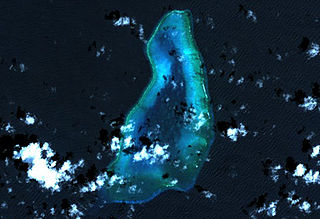
Blenheim Reef is a partly submerged atoll structure in the Chagos Archipelago, Indian Ocean. It includes the coral reef of Baxio Predassa in its southeastern rim, plus another completely submerged part. It is located in the northeastern part of the Chagos Archipelago. It measures almost eleven kilometres (north–south) by more than four kilometres (east–west), with a total area of 36.8 square kilometres, including the lagoon of 8.5 km2, the difference being accounted for the mostly by the reef flat. Only on the eastern side, there are a few sand cays above the water. The largest of them is East Island, which is not quite 200 metres long and 70 metres wide. The other islands in the group are North, Middle and South. Only a few grasses grow on the island. The lagoon is up to 18 metres deep and encumbered with rock. The fringing coral reef has a wide passage in the southwest. The closest land is Takamaka Island in the Salomon Islands Atoll, about 20 kilometres to the southwest.

Nazareth Bank is a large submerged bank in the Indian Ocean.
The Soudan Banks are a series of underwater high points and reefs off the coast of Africa, known for their good fishing yields as fishing banks. They are administered by Mauritius. The five banks lie on the Mascarene plateau. North Soudan contains large salmon stocks. South Soudan is the largest of the banks, with many reefs and passes. West Soudan is small, rocky, and shallow, and is the least fished of the banks. Central Soudan is the most fished area, with huge reefs and open waters containing a huge abundance of fish. East Soudan, until the 1970s, was considered to be a completely different formation altogether, since it is located more than 100 miles away from the other banks. The other banks are closely linked, separated by small shallows or channels.
An ocean bank, sometimes referred to as a fishing bank or simply bank, is a part of the seabed that is shallow compared to its surrounding area, such as a shoal or the top of an underwater hill. Somewhat like continental slopes, ocean bank slopes can upwell as tidal and other flows intercept them, sometimes resulting in nutrient-rich currents. Because of this, some large banks, such as Dogger Bank and the Grand Banks of Newfoundland, are among the richest fishing grounds in the world.
Robert Moresby was a captain of the East India Company's Bombay Marine/Indian Navy who distinguished himself as a hydrographer, maritime surveyor and draughtsman.

Wolf Hartmut Hilbertz was a German-born futurist architect, inventor, and marine scientist. Notable contributions to science include the discovery of artificial mineral accretetion / biorock and its use to create electrified reefs.

Biorock is a cement-like engineering material formed when a small electric current is passed between underwater metal electrodes placed in seawater causing dissolved minerals to accrete onto the cathode to form a thick layer of limestone. This 'accretion process' can be used to create building materials or to create artificial 'electrified reefs' for the benefit of corals and other sea-life. Discovered by Wolf Hilbertz in 1976, biorock was protected by patents and a trademark which have now expired.

Mauritia was a Precambrian microcontinent that was situated between India and Madagascar until their separation about 70 million years ago. Being initially attached to the Indian continent, Mauritia separated from it about 60 million years ago and further fragmented into a ribbon-like structure as the mid-ocean ridge jumped several times. The jumps of the mid-ocean ridge are thought to have been caused of its interaction with the Réunion hotspot as it passed under the West margin of the Indian continent and then under Mauritia. As of today, the fragments of Mauritia include the Laccadives–Maldives–Chagos Ridge, Nazareth Bank, the Saya de Malha Bank, and Hawkins Bank, as well as the islands of Réunion and Mauritius, where the continual crust is buried under basaltic lavas of the Réunion hotspot.

An electric reef is an artificial reef made from biorock, being limestone that forms rapidly in seawater on a metal structure from dissolved minerals in the presence of a small electric current. The first reefs of this type were created by Wolf Hilbertz and Thomas J. Goreau in the 1980s. By 2011 there were examples in over 20 countries.