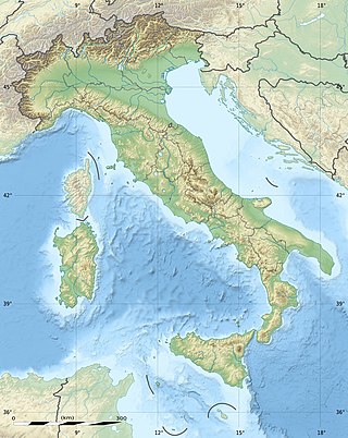
The geography of Italy includes the description of all the physical geographical elements of Italy. Italy, whose territory largely coincides with the homonymous geographical region, is located in southern Europe and comprises the long, boot-shaped Italian Peninsula crossed by the Apennines, the southern side of Alps, the large plain of the Po Valley and some islands including Sicily and Sardinia. Italy is part of the Northern Hemisphere. Two of the Pelagie Islands are located on the African continent.
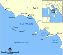
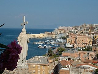
Gaeta is a city in the province of Latina, in Lazio, Southern Italy. Set on a promontory stretching towards the Gulf of Gaeta, it is 120 kilometres from Rome and 80 km (50 mi) from Naples.

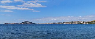
The Gulf of Naples, also called the Bay of Naples, is a roughly 15-kilometer-wide (9.3 mi) gulf located along the south-western coast of Italy. It opens to the west into the Mediterranean Sea. It is bordered on the north by the cities of Naples and Pozzuoli, on the east by Mount Vesuvius, and on the south by the Sorrento Peninsula and the main town of the peninsula, Sorrento. The Peninsula separates the Gulf of Naples from the Gulf of Salerno, which includes the Amalfi Coast.
The Province of Caserta is a province in the Campania region of southern Italy. Its capital is the city of Caserta, situated about 36 kilometres (22 mi) by road north of Naples. The province has an area of 2,651.35 square kilometres (1,023.69 sq mi), and had a total population of 924,414 in 2016. The Palace of Caserta is located near to the city, a former royal residence which was constructed for the Bourbon kings of Naples. It was the largest palace and one of the largest buildings erected in Europe during the 18th century. In 1997, the palace was designated a UNESCO World Heritage Site.
The Province of Frosinone is a province in the Lazio region of Italy, with 91 comuni. Its capital is the city of Frosinone. It has an area of 3,247 square kilometres (1,254 sq mi) and a total population of 493,605 (2016).

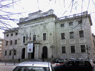
The Province of Latina is an area of local government at the level of province in the Republic of Italy. It is one of five provinces that form the region of Lazio. The provincial capital is the city of Latina. It is bordered by the provinces of Frosinone to the north-east and by the Metropolitan City of Rome Capital to the north-west.
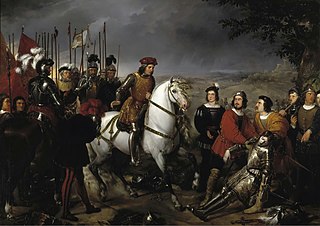
The Battle of Cerignola was fought on 28 April 1503 between Spanish and French armies outside the town of Cerignola, Apulia, Kingdom of Naples, approximately 80 kilometres (50 mi) west of Bari. The Spanish force under the command of Gonzalo Fernández de Córdoba comprising 6,300 men, including 2,000 Landsknecht pikemen, 1,000 arquebusiers and 20 cannons, defeated the French force of 9,000 men, mainly gendarme heavy cavalry and Swiss mercenary pikemen, with about 40 cannons, led by Louis d'Armagnac, Duke of Nemours, who was killed during the battle. It was one of the first European battles won by gunpowder weapons, as the attacks by the French cavalry and Swiss pikemen were shattered by the fire of Spanish arquebusiers behind a defensive ditch.

The Pontine Islands are an archipelago in the Tyrrhenian Sea off the coast of Lazio region, Italy. The islands were collectively named after the largest island in the group, Ponza. The other islands in the archipelago are Palmarola, Zannone, and Gavi to the northwest and Ventotene and Santo Stefano to the southeast. These two groups are separated by 22 nautical miles (41 km). From Sabaudia-Cape Circeo peninsula to Zannone the distance is 12 nautical miles (22 km), while Ventotene faces Gaeta. The minimum distance between Santo Stefano and the isle of Ischia is 22 nautical miles (41 km).

Central Italy is one of the five official statistical regions of Italy used by the National Institute of Statistics (ISTAT), a first-level NUTS region, and a European Parliament constituency.
Minturno is a city and comune in the southern Lazio, Italy, situated on the north west bank of the Garigliano, with a suburb on the opposite bank about 18 kilometres (11 mi) from its mouth, at the point where the Via Appia crossed it by the bridge called Pons Tiretius.

Sessa Aurunca is a town and comune in the province of Caserta, Campania, southern Italy. It is located on the south west slope of the extinct volcano of Roccamonfina, 40 kilometres (25 mi) by rail west north west of Caserta and 30 kilometres (19 mi) east of Formia.

The siege of Gaeta was the concluding event of the war between the Kingdom of Sardinia and the Kingdom of the Two Sicilies, part of the unification of Italy. It started on 5 November 1860 and ended on 13 February 1861, and took place in Gaeta, in today's Southern Lazio (Italy).

The Battle of Garigliano was fought on 29 December 1503 between a Spanish army under Gonzalo Fernández de Córdoba and a French army commanded by Ludovico II, Marquis of Saluzzo.

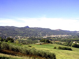
The Monti Aurunci is a mountain range of southern Lazio, in central Italy. It is part of the Antiappennini, a group running from the Apennines chain to the Tyrrhenian Sea, where it forms the promontory of Gaeta. It is bounded to the north-west by the Ausoni Mountains, to the north by the Liri river, to the east by the Ausente, to the south-east by the Garigliano and to the south by the Tyrrhenian sea. The line between the Aurunci and the Ausoni has not been clearly established but the Aurunci are considered by convention to be east of a line through Fondi, Lenola, Pico, S. Giovanni and Incarico. Altitudes vary from hills to the 1,533 m of Monte Petrella. Main peaks include the Redentore (1,252 m) and Monte Sant'Angelo (1,402 m). They include a regional park, the Parco Naturale dei Monti Aurunci, created in 1997.
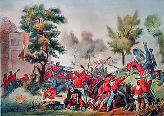
The Battle of the Volturno refers to a series of military clashes between Giuseppe Garibaldi's volunteers and the troops of the Kingdom of Two Sicilies occurring around the river Volturno, between the cities of Capua and Caserta in northern Campania, in September and October 1860. The main battle took place on the 1 October 1860 between 30,000 Garibaldines and 25,000 Bourbon troops (Neapolitans).

The Gulf of Pozzuoli, formerly known as the Gulf of Puteoli, is a large bay or small gulf in the northwestern end of the Gulf of Naples in the Tyrrhenian Sea. It lies west of Naples and is named for its port of Pozzuoli. The Roman Sinus Baianus was located within it, near the resort town of Baiae.
The siege of Gaeta was a three-month siege of the Italian city of Gaeta in 1707 by the forces of the Austrian monarchy under Wirich Philipp von Daun, during the War of the Spanish Succession. It ended on 30 September with the total destruction of the city's historic fortifications.
The siege of Gaeta saw the fortress city of Gaeta and its Neapolitan garrison under Louis of Hesse-Philippsthal besieged by an Imperial French corps led by André Masséna. After a prolonged defense in which Hesse was badly wounded, Gaeta surrendered and its garrison was granted generous terms by Masséna.
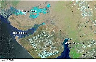
The Gulf of Khambhat, historically known as the Gulf of Cambay, is a bay on the Arabian Sea coast of India, bordering the state of Gujarat just north of Mumbai and Diu Island. The Gulf of Khambhat is about 200 km (120 mi) long, about 20 km (12 mi) wide in the north and up to 70 km (43 mi) wide in the south. Major rivers draining Gujarat are the Narmada, Tapti, Mahi and the Sabarmati, that form estuaries in the gulf.
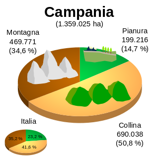
The geography of Campania illustrates the geographical characteristics of Campania, a region of Italy.