
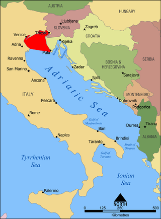
Slovenia is situated at the crossroads of central and southeast Europe, touching the Alps and bordering the Adriatic Sea. The Alps—including the Julian Alps, the Kamnik–Savinja Alps and the Karawank chain, as well as the Pohorje massif—dominate northern Slovenia along its long border to Austria. Slovenia's Adriatic coastline stretches approximately 47 km (29 mi) from Italy to Croatia. Its part south of Sava river belongs to Balkan peninsula – Balkans.

Istria is the largest peninsula within the Adriatic Sea. The peninsula is located at the head of the Adriatic between the Gulf of Trieste and the Kvarner Gulf. It is shared by three countries: Croatia, Slovenia, and Italy, with 90% of surface area being part of Croatia. Croatia encapsulates most of the Istrian peninsula within Istria County.

Koper is the fifth largest city in Slovenia. Located in the Istrian region in the southwestern part of the country, approximately five kilometres south of the border with Italy and 20 kilometres from Trieste, Koper is the largest coastal city in the country. It is bordered by the satellite towns of Izola and Ankaran. With a unique ecology and biodiversity, it is considered an important natural resource. The city's Port of Koper is Slovenia's only container port and a major contributor to the economy of the Municipality of Koper. The influence of the Port of Koper on tourism was one of the factors in Ankaran deciding to leave the municipality in a referendum in 2011 to establish its own municipality. The city is a destination for a number of Mediterranean cruising lines. Koper is the main urban centre of the Slovenian Istria, with a population of about 25,000. Aleš Bržan is the current mayor, serving since 2018.
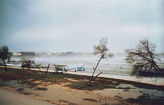
The bora is a northerly to north-easterly katabatic wind in areas near the Adriatic Sea. Similar nomenclature is used for north-eastern winds in other littoral areas of eastern Mediterranean and Black Sea basins.

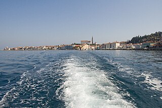
Piran is a town in southwestern Slovenia on the Gulf of Piran on the Adriatic Sea. It is one of the three major towns of Slovenian Istria. The town is known for its medieval architecture, with narrow streets and compact houses. Piran is the administrative seat of the Municipality of Piran and one of Slovenia's major tourist attractions. Until the mid-20th century, Italian was the dominant language, but it was replaced by Slovene following the Istrian exodus.
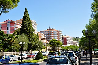
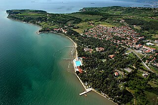
Portorož is a Slovenian Adriatic seaside resort and spa settlement located in the Municipality of Piran in southwestern Slovenia. Its modern development began in the late 19th century with the vogue for the first health resorts. In the early 20th century Portorož became one of the grandest seaside resorts in the Adriatic, along with Opatija, Lido and Grado, then as part of the Austrian Littoral. It is now one of Slovenia's major tourist areas. Located in the centre is the Palace Hotel, once one of the most important resorts for the Austro-Hungarian monarchy, and currently one of the finest hotels between Venice and Dubrovnik.
The Gulf of Venice is an informally recognized gulf of the Adriatic Sea. It lies at the extreme north end of the Adriatic, limited on the southwest by the easternmost point of the Po Delta in Italy and on the southeast by the southernmost point of the Istrian Peninsula in Croatia. It is bordered by the coastlines of northeastern Italy and southwestern Croatia and Slovenia.
The Gulf of Piran or Piran Bay is located in the northern part of the Adriatic Sea, and is a part of the southernmost tip of the Gulf of Trieste.
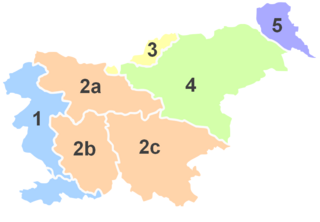
The Slovene Littoral or simply Littoral is one of the traditional regions of Slovenia. The littoral in its name – for a coastal-adjacent area – recalls the former Austrian Littoral, the Habsburg possessions on the upper Adriatic coast, of which the Slovene Littoral was part. Today, the Littoral is often associated with the Slovenian ethnic territory that, in the first half of the 20th century, found itself in Italy to the west of the Rapallo Border, which separated a quarter of Slovenes from the rest of the nation, and was strongly influenced by Italian fascism.

The Natisone is a 60-kilometre (37 mi) river in Slovenia and Italy. It flows for some time as a border river between Slovenia and Italy, continues in Slovenia and then crosses the border and continues in Eastern Friuli, in northeastern Italy. It is the main tributary of the Torre and a sub-affluent of the Isonzo. It has a pluvio-nival regime and belongs to the Adriatic Sea Basin.

The Reka, also the Inner Carniola Reka, is a river that starts as Big Creek in Croatia, on the southern side of Mount Snežnik, and flows through western Slovenia, where it is also initially known as Big Creek. The river is 54 km (34 mi) long, of which 51 km (32 mi) is in Slovenia. At the village of Škocjan it disappears underground through Škocjan Caves, flowing 38 km (24 mi) underneath the Slovenian Karst. The river continues as part of the Timavo in Italy. Tracer studies have shown that it also feeds springs elsewhere on the Adriatic Coast between Trieste and Monfalcone. It has a pluvial regime.

The Dragonja is a 30-kilometre (19 mi) long river in the northern part of the Istrian peninsula. It is a meandering river with a very branched basin and a small quantity of water. It has a pluvial regime and often dries up in summer. It features very diverse living environments and is home to a number of animal and plant species. The Dragonja has been a matter of a territorial dispute between Croatia and Slovenia, with its lowest portion de facto the border of the two countries.
Ankaran is a town in the Municipality of Ankaran, located near the border with Italy, in the Littoral region of Slovenia. It is less than 5 km from the Italian town of Muggia near Trieste, about 2.5 km from the Italian-Slovenian border, 6.5 km from Koper, and 33 km from the nearest Croatian town, Buje. In the entire municipality both Slovenian and Italian are official languages.

Plavje is a village in the City Municipality of Koper in the Littoral region of Slovenia. It is located on the northernmost edge of the Istrian peninsula, on the border with Italy, on a small hill overlooking the Gulf of Trieste.

The Adriatic Sea is a body of water separating the Italian Peninsula from the Balkan Peninsula. The Adriatic is the northernmost arm of the Mediterranean Sea, extending from the Strait of Otranto to the northwest and the Po Valley. The countries with coasts on the Adriatic are Albania, Bosnia and Herzegovina, Croatia, Italy, Montenegro, and Slovenia.

Istrian Italians are an ethnic group from the Adriatic region of Istria in modern northwestern Croatia and southwestern Slovenia. Istrian Italians descend from the original Latinized population of Roman Histria, from the Venetian-speaking settlers who colonized the region during the time of the Republic of Venice, and from the local Croatian people who culturally assimilated.

Slovene Istria is a region in southwest Slovenia. It comprises the northern part of the Istrian peninsula, and is part of the wider geographical-historical region known as the Slovene Littoral. Its largest urban center is Koper. Other large settlements are Izola, Piran, and Portorož. The entire region has around 120 settlements. In its coastal area, both Slovene and Italian are official languages.

The Slovene Riviera is the coastline of Slovenia, located on the Gulf of Trieste, by the Adriatic Sea. It is part of the Istrian peninsula and is 46.6 km long. The region comprises the towns of Koper and Piran with Portorož, and the municipality of Izola. It is a seaside tourist destination, with a vibrant multiethnic Slovenian and Italian heritage.

The Gulf of Koper or Koper Bay is located in the northern part of the Adriatic Sea, and is a part of the Gulf of Trieste.

The Municipality of Piran is a municipality in the traditional region of the Littoral in southwestern Slovenia. The seat of the municipality is the town of Piran. Piran became a municipality in 1994.


