HMY Iolaire

Last updated

Admiralty-yacht-HMS-Iolaire-ship-Amalthaea-1908.jpg
As Amalthaea in 1908
History
Naval Ensign of the United Kingdom.svg United Kingdom
NameIolaire
NamesakeEagle (in Scottish Gaelic)
Owner Royal Navy
Launched1881
FateWrecked, 1 January 1919
General characteristics
Class and typeYacht
Iolaire wrecked on the "Beasts of Holm" Het Engelse stoomjacht met 350 opvarenden lijdt schipbreuk bij 'Beast of Holm', riffen voor de, SFA022806671.jpg
Iolaire wrecked on the "Beasts of Holm"
Lifeboat from the Iolaire Een van de reddingsboten van de vergane 'Iolaire' is tegen de rotsen geslagen, SFA022806673.jpg
Lifeboat from the Iolaire

HMY Iolaire was an Admiralty Yacht that sank at the entrance to Stornoway harbour on 1 January 1919, with the loss of at least 201 men out of the 283 on board. The overcrowded vessel was trying to negotiate a difficult route under exceptionally bad weather conditions. The disaster cost the Isle of Lewis almost the whole of its young male population.

Contents

Sinking

His Majesty's Yacht Iolaire ( Scottish Gaelic for ' Eagle ') [lower-alpha 1] was an Admiralty yacht, launched as the Iolanthe, previously also named the Amalthaea and re-named in 1918. She was carrying sailors who had fought in the First World War back to the Scottish Isle of Lewis in the Outer Hebrides. She left the port of Kyle of Lochalsh on the mainland late on the evening of 31 December 1918. At 2:30 a.m. on New Year's Day, as the ship approached the port of Stornoway, a few yards offshore and a mile away from the safety of Stornoway Harbour, she hit the infamous rocks "The Beasts of Holm" and sank. Those on board would have been able to see the lights of Stornoway. The death toll was officially put at 205, of whom 181 men were islanders but as the ship was badly overcrowded and there was a lack of proper records, the toll could have been somewhat higher.

John F. Macleod from Ness, Isle of Lewis saved 40 lives, swimming ashore with a heaving line, along which many of the survivors made their way to safety. Only 82 of the 283 (officially known) passengers survived the disaster; 71% of the men on the yacht died in the incident. [1] The impact of the disaster was devastating to the Islands; 205 passengers were lost, representing almost an entire generation of young men from the Islands.

The sailors were wearing their uniforms including heavy boots, which made swimming from the wreck difficult; many men of that time had never had the opportunity to learn. Many songs and poems, such as An Iolaire, describe the women of these men finding their men washed up on the shore the next day. The sinking is the worst maritime disaster (for loss of life) in United Kingdom waters in peacetime, since the wreck of the SS Norge off Rockall in 1904 and the worst peacetime disaster involving a British ship since Titanic on 15 April 1912. [1]

An Admiralty enquiry found no satisfactory explanation for the disaster. Its inconclusive findings generated much ill feeling amongst the Lewis population, amidst accusations of a "whitewash". While drunkenness among the crew was discounted at the enquiry, the vessel was sailing at night, in poor visibility and in deteriorating weather. The entrance to Stornoway harbour is not the most straightforward of navigations and it is possible that navigational error was to blame.[ citation needed ] This hypothesis appears to be supported by the crew of a fishing vessel who noted that Iolaire was not navigating the correct course for entering the harbour.

Memorial

Iolaire memorial Iolaire Memorial.jpg
Iolaire memorial

The sinking was one of the worst maritime disasters in British waters during the 20th century. A memorial was erected in 1958 at Holm, outside Stornoway. [2] A stone pillar sticks out of the water at the site of the wreck, which can be seen to starboard as the car ferry approaches the harbour entrance. The community-led commemoration of the centenary was marked in a number of ways including by musicians such as Julie Fowlis and Duncan Chisholm, as well as local artists such as Malcolm Maclean. [3] The disaster has been included in the Arts and Humanities Research Council "Living Legacies (1914-18)" project, led by Abertay University and The Centre for History, University of the Highlands and Islands and the resulting app highlights the nature and extent of the loss felt by families and communities. [4]

A national commemorative service was held at the memorial on 1 January 2019 to mark the centenary of the disaster, attended by First Minister of Scotland Nicola Sturgeon and Prince Charles, Duke of Rothesay, who unveiled a new memorial at Holm which depicts the rope used by John F. MacLeod to save 40 lives. [5] [6]

See also

Notes

  1. Scottish Gaelic pronunciation: [ˈjul̪ˠɪɾə] or [ˈjul̪ˠɪðə] , varying slightly according to the dialect; the English-speaking crew used a spelling pronunciation of /ˈ.əlɛər/ and this was also adopted by Gaelic speakers.

Footnotes

  1. 1 2 "Sinking of HMY Iolaire - list of all on board at time of grounding". Across Two Seas. 17 December 2008. Retrieved 14 November 2017.
  2. "Iolaire Memorial". Gazetteer for Scotland . Retrieved 26 July 2009.
  3. "Isle of Lewis prepares mass commemoration for people of Iolaire". www.scotsman.com. Retrieved 14 April 2019.
  4. "Visualising the lolaire". Living Legacies 1914-18. Archived from the original on 14 April 2019. Retrieved 14 April 2019.
  5. "Commemorative service for Iolaire disaster". BBC News. 1 January 2019. Retrieved 1 January 2019.
  6. "Iolaire Commemorative Sculpture Unveiled". Gael Force Group. Retrieved 14 April 2019.

Related Research Articles

<span class="mw-page-title-main">Outer Hebrides</span> Archipelago and council area off the west coast of mainland Scotland

The Outer Hebrides or Western Isles, sometimes known as the Long Isle or Long Island, is an island chain off the west coast of mainland Scotland. The islands are geographically coextensive with Comhairle nan Eilean Siar, one of the 32 unitary council areas of Scotland. They form part of the archipelago of the Hebrides, separated from the Scottish mainland and from the Inner Hebrides by the waters of the Minch, the Little Minch, and the Sea of the Hebrides.

<span class="mw-page-title-main">Isle of Lewis</span> Region of Lewis and Harris island, Scotland

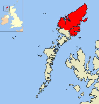
The Isle of Lewis or simply Lewis is the northern part of Lewis and Harris, the largest island of the Western Isles or Outer Hebrides archipelago in Scotland. The two parts are frequently referred to as if they were separate islands. The total area of Lewis is 683 square miles (1,770 km2).

<span class="mw-page-title-main">Stornoway</span> Town on the Isle of Lewis, in Scotland

Stornoway is the main town, and by far the largest town, of the Outer Hebrides, or Western Isles, and the capital of Lewis and Harris in Scotland.

<span class="mw-page-title-main">Kyle of Lochalsh</span> Human settlement in Scotland

Kyle of Lochalsh is a village in the historic county of Ross & Cromarty on the northwest coast of Scotland, located around 55 miles (90 km) west-southwest of Inverness. It is located on the Lochalsh peninsula, at the entrance to Loch Alsh, opposite the village of Kyleakin on the Isle of Skye. A ferry used to connect the two villages until it was replaced by the Skye Bridge, about a mile (2 km) to the west, in 1995.

<span class="mw-page-title-main">Point, Lewis</span>

Point, also known as the Eye Peninsula, is a peninsula some 11 km long in the Outer Hebrides, Scotland. The majority of Point is connected to the rest of the Isle of Lewis by a narrow isthmus, one mile in length and at one point barely 100 metres wide. The peninsula is just 6 km east of the regional capital of Stornoway, however the district of Point actually starts at the Parkend estate on Stornoway's outskirts. Point is home to around 2,600 people and is one of the few districts of the Western Isles where the population is increasing. There are about 17 villages and hamlets in Point: Melbost (Mealabost), Branahuie, Aignish (Aiginis), Knock, Swordale (Suardail), Garrabost, Lower Bayble, Eagleton, Upper Bayble, Shulishader, Sheshader (Seisiader), Flesherin (Fleisirin), Cnoc Amhlaigh, Portnaguran, Aird, Broker (Brocair), and Portvoller.

<span class="mw-page-title-main">Ness, Lewis</span> Human settlement in Scotland

Ness is the northernmost part of the Isle of Lewis, a community consisting of about 16 villages, including Lionel, Habost, Swainbost, Cross, North and South Dell, Cross Skigersta, Skigersta, Eorodale, Adabroc, Port of Ness, Knockaird, Fivepenny and Eoropie. It was the most north-westerly community in the European Union, when the United Kingdom was a member. Its most northerly point is the Butt of Lewis. The name Ness derives from the old Norse for headland and many of the other place names in the area also have a Norse origin.

<span class="mw-page-title-main">Aignish</span> Human settlement in Scotland

Aignish is located northwest of Knock and east of Stornoway on the east coast of the Isle of Lewis, in the Outer Hebrides, Scotland. The township is at the island side of the isthmus connecting to the Eye peninsula. Aignish is within the parish of Stornoway, and is situated on the A866 between Stornoway and Portnaguran.

<span class="mw-page-title-main">Melbost</span> Human settlement in Scotland

Melbost is a traditionally Gaelic-speaking village in Point on the east coast of the Isle of Lewis, in Scotland's north-west. It is largely a crofting township and is about 2+12 miles east of Stornoway at the head of an isthmus connecting with the Eye Peninsula. Melbost is technically in the district of Point; however, it is not located on the Eye Peninsula itself. The RAF Stornoway war memorial is located in the village.

<span class="mw-page-title-main">Gress</span> Human settlement in Scotland

Gress, a hamlet on the Isle of Lewis in Scotland, is adjacent to the larger village of Back. Gress is within the parish of Stornoway. Between 1919 and 1921, Gress – along with nearby Coll and Tong – was the scene of several land raids.

<span class="mw-page-title-main">Lewis War Memorial</span> War memorial in Outer Hebrides, Scotland, UK

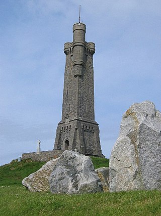
The Lewis War Memorial is a war memorial dedicated to the men from the Lewis area who lost their lives in World War I and those who survived the war only to drown while returning home during the 1919 sinking of HMY Iolaire. Completed in 1924, the memorial is situated at the highest point of the town of Stornoway.

<span class="mw-page-title-main">History of the Outer Hebrides</span>

The Hebrides were settled early on in the settlement of the British Isles, perhaps as early as the Mesolithic era, around 8500–8250 BC, after the climatic conditions improved enough to sustain human settlement. There are examples of structures possibly dating from up to 3000 BC, the finest example being the standing stones at Callanish, but some archaeologists date the site as Bronze Age. Little is known of the people who settled in the Hebrides but they were likely of the same Celtic stock that had settled in the rest of Scotland. Settlements at Northton, Harris, have both Beaker & Neolithic dwelling houses, the oldest in the Western Isles, attesting to the settlement.

<span class="mw-page-title-main">Holm, Lewis</span> Human settlement in Scotland

Holm Village is a village in the Scottish Outer Hebrides, on the Isle of Lewis near Stornoway. The modern area of Holm can be split into two distinct areas - "Holm Village" and "Holm Road with Parkend". Holm is within the parish of Stornoway.

<span class="mw-page-title-main">Parkend, Lewis</span> Human settlement in Scotland

Parkend is a hamlet in the Sandwick region of the Isle of Lewis, although like Melbost, it is not a part of the Eye Peninsula. Many people erroneously believe it to be a suburb of Stornoway, on the island of Lewis and Harris in the Outer Hebrides of Scotland. Parkend is within the parish of Stornoway. Parkend is situated on the A866, and the adjoining Holm Road allows access to the nearby Holm Village. The Parkend Industrial Estate is adjacent to the small housing estate.

<span class="mw-page-title-main">Borve, Lewis</span> Human settlement in Scotland

Borve is a village on the west side of the Isle of Lewis in Scotland, 17 miles from the island's only town, Stornoway.

<span class="mw-page-title-main">Cross, Lewis</span> Human settlement in Scotland

Cross is a township on the Isle of Lewis in the community of Ness, in the Outer Hebrides, Scotland. Cross is within the parish of Barvas. Cross is also situated on the A857, between Stornoway and Port of Ness.

<span class="mw-page-title-main">Swainbost</span> Human settlement in Scotland

Swainbost is a village on the Isle of Lewis in the district of Ness, in the Outer Hebrides, Scotland. The name Swainbost meaning Sweins steading is of Viking derivation. The settlement is situated in the parish of Barvas. According to Ronald Black, Swainbost was re-settled during the Highland Clearances in 1842. The island's Anglo-Scottish landlord had expected the crofters evicted from Uig to emigrate and only reluctantly granted them land at Swainbost to avert the threat of violence.

<span class="mw-page-title-main">Port of Ness</span> Human settlement in Scotland

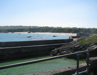
Port of Ness is a village on the Isle of Lewis in the community of Ness, in the Outer Hebrides, Scotland. Port of Ness is within the parish of Barvas. Port of Ness is situated at the end of the A857, which runs from Stornoway. In 2014, the Ness Fishery Memorial was erected to celebrate the fishing heritage in the area and to commemorate the 96 people who lost their lives in the industry between 1835 and 1900.

<span class="mw-page-title-main">Lewis and Harris</span> Largest island in Scotland, part of the Outer Hebrides

Lewis and Harris, or Lewis with Harris, is a single Scottish island in the Outer Hebrides, divided by mountains. It is the largest island in Scotland and the third largest in the British Isles, after Great Britain and the island of Ireland, with an area of 841 square miles (2,178 km2), which is approximately 1% of the area of Great Britain. The northern two-thirds is called [the Isle of] Lewis and the southern third [the Isle of] Harris; each is referred to as if it were a separate island and there are many cultural and linguistic differences between the two.

Events from the year 1919 in Scotland.

References

58°11′16″N6°20′59″W / 58.18774°N 6.34971°W / 58.18774; -6.34971 (Wreck site of HMY Iolaire)