Hamilton County, Nebraska

Last updated

Hamilton County
Hamilton County courthouse, Aurora, Nebraska, USA.jpg
Hamilton County courthouse in Aurora
Map of Nebraska highlighting Hamilton County.svg
Location within the U.S. state of Nebraska
Nebraska in United States.svg
Nebraska's location within the U.S.
Coordinates: 40°53′N98°01′W / 40.88°N 98.02°W / 40.88; -98.02
CountryFlag of the United States.svg United States
StateFlag of Nebraska.svg  Nebraska
Founded1867 (created)
1870 (organized)
Named for Alexander Hamilton
Seat Aurora
Largest cityAurora
Area
  Total547 sq mi (1,420 km2)
  Land544 sq mi (1,410 km2)
  Water4.1 sq mi (11 km2)  0.8%
Population
 (2020)
  Total9,429
  Density17/sq mi (6.7/km2)
Time zone UTC−6 (Central)
  Summer (DST) UTC−5 (CDT)
Congressional district 3rd
Website www.co.hamilton.ne.us

Hamilton County is a county in the U.S. state Nebraska. As of the 2020 United States Census, the population was 9,429. [1] Its county seat is Aurora. [2] The county was named for Alexander Hamilton, the first Secretary of the Treasury in the new United States government.

Contents

Hamilton County is included in the Grand Island, NE Metropolitan Statistical Area.

In the Nebraska license plate system, Hamilton County is represented by the prefix 28 (it had the 28th-largest number of vehicles registered in the county when the license plate system was established in 1922).

History

The first permanent settlers arrived in Hamilton County in 1866. [3] Hamilton County was created in 1867, [4] and was organized in 1870. [5] [6] It was named for Alexander Hamilton. [7]

Geography

The Platte River flows northeastward along the northwest side of Hamilton County, forming the northwestern boundary line with Merrick County.

According to the U.S. Census Bureau, the county has a total area of 547 square miles (1,420 km2), of which 543 square miles (1,410 km2) is land and 4.1 square miles (11 km2) (0.8%) is water. [8]

Major highways

Adjacent counties

Protected areas

Demographics

Historical population
CensusPop.Note
1870 130
1880 8,2676,259.2%
1890 14,09670.5%
1900 13,330−5.4%
1910 13,4591.0%
1920 13,237−1.6%
1930 12,159−8.1%
1940 9,982−17.9%
1950 8,778−12.1%
1960 8,714−0.7%
1970 8,8671.8%
1980 9,3014.9%
1990 8,862−4.7%
2000 9,4036.1%
2010 9,124−3.0%
2020 9,4293.3%
US Decennial Census [16]
1790-1960 [17] 1900-1990 [18]
1990-2000 [19] 2010 [20]

As of the 2000 United States Census, [21] there were 9,403 people, 3,503 households, and 2,676 families residing in the county. The population density was 17 people per square mile (6.6 people/km2). There were 3,850 housing units at an average density of 7 units per square mile (2.7/km2). The racial makeup of the county was 98.43% White, 0.18% Black or African American, 0.12% Native American, 0.22% Asian, 0.49% from other races, and 0.56% from two or more races. 1.14% of the population were Hispanic or Latino of any race.

There were 3,503 households, out of which 37.30% had children under the age of 18 living with them, 67.40% were married couples living together, 5.90% had a female householder with no husband present, and 23.60% were non-families. 21.10% of all households were made up of individuals, and 10.10% had someone living alone who was 65 years of age or older. The average household size was 2.64 and the average family size was 3.07.

The county population contained 29.10% under the age of 18, 5.90% from 18 to 24, 26.50% from 25 to 44, 23.20% from 45 to 64, and 15.30% who were 65 years of age or older. The median age was 38 years. For every 100 females there were 99.40 males. For every 100 females age 18 and over, there were 96.10 males.

The median income for a household in the county was $40,277, and the median income for a family was $45,659. Males had a median income of $29,238 versus $20,308 for females. The per capita income for the county was $17,590. About 5.90% of families and 7.50% of the population were below the poverty line, including 9.80% of those under age 18 and 5.40% of those age 65 or over.

Communities

City

Villages

Census-designated place

Politics

Hamilton County voters have long been reliably Republican. In only one national election since 1916 has the county selected the Democratic Party candidate.

United States presidential election results for Hamilton County, Nebraska [22]
Year Republican Democratic Third party
No.%No.%No.%
2020 4,30977.42%1,11820.09%1392.50%
2016 3,78375.60%87817.55%3436.85%
2012 3,60073.91%1,14623.53%1252.57%
2008 3,38970.62%1,33227.76%781.63%
2004 3,78577.78%1,01220.80%691.42%
2000 3,25172.39%1,06623.74%1743.87%
1996 2,62361.37%1,17227.42%47911.21%
1992 2,38851.72%99421.53%1,23526.75%
1988 3,02269.73%1,28929.74%230.53%
1984 3,41879.77%84219.65%250.58%
1980 3,20074.92%77818.22%2936.86%
1976 2,73765.46%1,33731.98%1072.56%
1972 2,96076.55%90723.45%00.00%
1968 2,59270.94%91825.12%1443.94%
1964 2,10552.74%1,88647.26%00.00%
1960 3,24972.65%1,22327.35%00.00%
1956 3,21774.95%1,07525.05%00.00%
1952 3,57976.00%1,13024.00%00.00%
1948 2,40661.46%1,50938.54%00.00%
1944 3,05769.68%1,33030.32%00.00%
1940 3,28666.36%1,66633.64%00.00%
1936 2,74850.43%2,65348.69%480.88%
1932 2,00339.66%2,96958.78%791.56%
1928 3,63468.77%1,60630.39%440.83%
1924 2,93556.12%1,54529.54%75014.34%
1920 2,95066.89%1,35630.75%1042.36%
1916 1,44443.16%1,81654.27%862.57%
1912 45014.57%1,43346.41%1,20539.02%
1908 1,63347.36%1,66448.26%1514.38%
1904 1,84561.38%55118.33%61020.29%
1900 1,52447.85%1,57149.32%902.83%

See also

Related Research Articles

<span class="mw-page-title-main">Clay County, Nebraska</span> County in Nebraska, United States

Clay County is a county in the U.S. state of Nebraska. As of the 2020 United States Census, the population was 6,104. Its county seat is Clay Center. The county was formed in 1855, and was organized in 1871. It was named for Henry Clay, a member of the United States Senate from Kentucky, who went on to become United States Secretary of State.

<span class="mw-page-title-main">Charles Mix County, South Dakota</span> County in South Dakota, United States

Charles Mix County is a county in the U.S. state of South Dakota. As of the 2020 census, the population was 9,373. Its county seat is Lake Andes. The county was created in 1862 and organized in 1879. It was named for Charles Eli Mix, an official of the Bureau of Indian Affairs influential in signing a peace treaty with the local Lakota Indian tribes. The easternmost approximately 60% of the county comprises the Yankton Indian Reservation.

<span class="mw-page-title-main">Aurora County, South Dakota</span> County in South Dakota, United States

Aurora County is a county in the U.S. state of South Dakota. As of the 2020 census, the population was 2,747. The county was created in 1879, and was organized in 1881.

<span class="mw-page-title-main">York County, Nebraska</span> County in Nebraska, United States

York County is a county in the U.S. state of Nebraska. As of the 2020 United States Census, the population was 14,125. Its county seat is York.

<span class="mw-page-title-main">Stanton County, Nebraska</span> County in Nebraska, United States

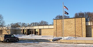
Stanton County is a county in the U.S. state of Nebraska. As of the 2020 United States Census, the population was 5,842. Its county seat is Stanton. The county was formed in 1856 and organized in 1867. It was first called Izard County until 1862, when it was renamed for Edwin M. Stanton, Secretary of War during the administration of President Abraham Lincoln.

<span class="mw-page-title-main">Seward County, Nebraska</span> County in Nebraska, United States

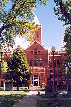
Seward County is a county in the U.S. state of Nebraska, United States. As of the 2020 United States Census, the population was 17,609. Its county seat is Seward. The county was formed in 1855, and was organized in 1867. It was originally called Greene County, and in 1862 it was renamed for William H. Seward, Secretary of State under Abraham Lincoln and Andrew Johnson. Seward County is part of the Lincoln, NE Metropolitan Statistical Area.

<span class="mw-page-title-main">Scotts Bluff County, Nebraska</span> County in Nebraska, United States

Scotts Bluff County is a county on the western border of the U.S. state of Nebraska. As of the 2020 United States Census, the population was 36,084. Its county seat is Gering, and its largest city is Scottsbluff.

<span class="mw-page-title-main">Saunders County, Nebraska</span> County in Nebraska, United States

Saunders County is a county in the U.S. state of Nebraska. As of the 2020 United States Census, the population was 22,278. Its county seat is Wahoo.

<span class="mw-page-title-main">Phelps County, Nebraska</span> County in Nebraska, United States

Phelps County is a county in the U.S. state of Nebraska. As of the 2020 United States Census, the population was 8,968. Its county seat is Holdrege. The county was formed in 1873, and was named for William Phelps (1808–1889), a steamboat captain and early settler.

<span class="mw-page-title-main">Madison County, Nebraska</span> County in Nebraska, United States

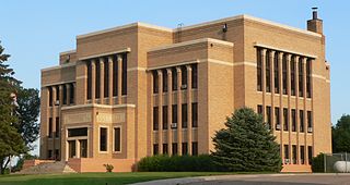
Madison County is a county in the U.S. state of Nebraska. As of the 2020 United States Census, the population was 35,585. Its county seat is Madison and its largest city is Norfolk. Madison County was likely named for Madison, Wisconsin, which is where many of the county’s residents came from; the city was named for James Madison, fourth President of the United States.

<span class="mw-page-title-main">Lincoln County, Nebraska</span> County in Nebraska, United States

Lincoln County is a county located in the U.S. state of Nebraska. As of the 2020 census, the population was 34,676. Its county seat is North Platte. Despite the county's name, the state capital city of Lincoln is not in or near Lincoln County.

<span class="mw-page-title-main">Knox County, Nebraska</span> County in Nebraska, United States

Knox County is a county in the U.S. state of Nebraska. As of the 2020 United States Census, the population was 8,391. Its county seat is Center. Knox County was named for Continental and U.S. Army Major General Henry Knox.

<span class="mw-page-title-main">Keith County, Nebraska</span> County in Nebraska, United States

Keith County is a county in the U.S. state of Nebraska. As of the 2020 United States Census, the population was 8,335. Its county seat is Ogallala.

<span class="mw-page-title-main">Kearney County, Nebraska</span> County in Nebraska, United States

Kearney County is a county located in the U.S. state of Nebraska. As of the 2020 United States Census, the population was 6,688. Its county seat is Minden. The county was formed in 1860. It was named for Fort Kearny, which in turn was named for Brigade General Stephen W. Kearny.

<span class="mw-page-title-main">Harlan County, Nebraska</span> County in Nebraska, United States

Harlan County is a county in the U.S. state of Nebraska. As of the 2020 United States Census, the population was 3,073. Its county seat is Alma. The county is home to the Harlan County Reservoir.

<span class="mw-page-title-main">Hall County, Nebraska</span> County in Nebraska, United States

Hall County is a county in the U.S. state of Nebraska. As of the 2020 United States Census, the population was 62,895, making it Nebraska's fourth-most populous county. Its county seat is Grand Island. The county was formed in 1858; it was named for Augustus Hall, an early judge of this territory.

<span class="mw-page-title-main">Gosper County, Nebraska</span> County in Nebraska, United States

Gosper County is a county located in the U.S. state of Nebraska. As of the 2020 United States census, the population was 1,893. Its county seat is Elwood. The county was formed in 1873, and was organized in 1881. It was named for John J. Gosper, a Nebraska Secretary of State.

<span class="mw-page-title-main">Garfield County, Nebraska</span> County in Nebraska, United States

Garfield County is a county in the U.S. state of Nebraska. As of the 2020 United States Census, the population was 1,813. Its county seat is Burwell. The county was organized in 1884; it was named for James A. Garfield, 20th President of the United States.

<span class="mw-page-title-main">Dawson County, Nebraska</span> County in Nebraska, United States

Dawson County is a county in the U.S. state of Nebraska. As of the 2020 United States Census, the population was 24,111. Its county seat is Lexington.

<span class="mw-page-title-main">Cedar County, Nebraska</span> County in Nebraska, United States

Cedar County is a county in the U.S. state of Nebraska. As of the 2020 United States Census, the population was 8,380. The county seat is Hartington. The county was formed in 1857, and was named for the Cedar tree groves in the area.

References

  1. "Hamilton County, Nebraska". United States Census Bureau . Retrieved June 19, 2023.
  2. "Find a County". National Association of Counties. Retrieved June 7, 2011.
  3. Burr, George L. (1921). History of Hamilton and Clay Counties, Nebraska, Vol. 1. S.J. Clarke Pub. Co. p. 116.
  4. Fitzpatrick, Lilian Linder (1925). Nebraska Place-Names. Lincoln: University of Nebraska Studies in Language, Literature, and Criticism. p. 70. Retrieved December 15, 2014.
  5. "Hamilton County Nebraska Historic Buildings Survey" (PDF). Nebraska State Historical Society. July 2009. Archived from the original on July 15, 2012. Retrieved December 15, 2014.{{cite web}}: CS1 maint: unfit URL (link)
  6. Andreas, A. T. (1882). "Andreas' History of the State of Nebraska". The Kansas Collection. Archived from the original on May 8, 2003. Retrieved December 15, 2014.
  7. "Hamilton County". Archived from the original on August 19, 2008. Retrieved March 9, 2010. Retrieved on March 15, 2008.
  8. "2010 Census Gazetteer Files". United States Census Bureau. August 22, 2012. Archived from the original on November 13, 2013. Retrieved December 8, 2014.
  9. Gadwall State Wildlife Management Area, Aurora NE Google Maps (accessed 21 January 2019)
  10. Nelson Federal Waterfowl Production Area, Aurora NE Google Maps (accessed 21 January 2019)
  11. Pintail State Wildlife Management Area, Aurora NE Google Maps (accessed 21 January 2019)
  12. Rainwater Basin Wildlife Management District, Aurora NE Google Maps (accessed 21 January 2019)
  13. Springer Federal Waterfowl Production Area, Aurota NE Google Maps (accessed 21 January 2019)
  14. Troester Federal Waterfowl Production Area, Aurora NE Google Maps (accessed 21 January 2019)
  15. Deep Well State Wildlife Management Area, Phillips NE Google Maps (accessed 21 January 2019)
  16. "US Decennial Census". US Census Bureau. Retrieved December 8, 2014.
  17. "Historical Census Browser". University of Virginia Library. Retrieved December 8, 2014.
  18. "Population of Counties by Decennial Census: 1900 to 1990". US Census Bureau. Retrieved December 8, 2014.
  19. "Census 2000 PHC-T-4. Ranking Tables for Counties: 1990 and 2000" (PDF). US Census Bureau. Archived (PDF) from the original on March 27, 2010. Retrieved December 8, 2014.
  20. "State & County QuickFacts". US Census Bureau. Archived from the original on June 7, 2011. Retrieved September 20, 2013.
  21. "U.S. Census website". US Census Bureau. Retrieved January 31, 2008.
  22. Election Results

40°53′N98°01′W / 40.88°N 98.02°W / 40.88; -98.02