Harahan Bridge

Last updated

Harahan Bridge
Harahan Bridge Memphis TN 04.jpg
Harahan Bridge from Martyrs Park
Coordinates 35°07′45″N90°04′33″W / 35.12917°N 90.07583°W / 35.12917; -90.07583
Carries Union Pacific Railroad and pedestrians
Crosses Mississippi River
Locale West Memphis, Arkansas and Memphis, Tennessee
Maintained by Union Pacific Railroad
Characteristics
Design Cantilevered through Truss bridge
Total length4,973 feet (1,516 m)
Longest span791 feet (241 m)
Clearance below 108 feet (33 m)
Rail characteristics
No. of tracks 2
History
OpenedJuly 14, 1916
Statistics
Daily traffic 13.2 trains per day (as of 2014) [1]
Location
Harahan Bridge

The Harahan Bridge is a cantilevered through truss bridge [2] that carries two rail lines and a pedestrian bridge across the Mississippi River between West Memphis, Arkansas, and Memphis, Tennessee. The bridge is owned and operated by Union Pacific Railroad and is the second longest pedestrian/bicycle bridge in the United States (after the Walkway Over the Hudson in Poughkeepsie, New York). It was built with roadways cantilevered off the sides of the main structure for vehicles. [3] These roadways are owned by the cities of Memphis, Tennessee, and Crittenden County, Arkansas, and were used from 1917–1949, until the Memphis & Arkansas Bridge opened 400 feet (120 m) south of the Harahan. [4] [5] [6] The bridge was named in honor of railroad executive James Theodore Harahan, former president of the Illinois Central Railroad, who was killed in a railroad accident during the construction of the bridge. [7] In February 2011, Union Pacific Railroad officials agreed to the idea of converting the 1917 roadways into a bicycle-pedestrian walkway across the river. [8] [9] In June 2012, Memphis was awarded a $14.9 million federal grant to build the walkway. The overall project was expected to cost $30 million, of which about $11 million was used for the Harahan Bridge portion. [10] [11] Construction was completed in 2016.

Contents

Description

The Harahan Bridge is in total 4,973 feet (1,516 m) long while the main bridge is 2,550 feet (780 m) from the east anchorage on the Memphis Bluffs to Pier 5 on the Arkansas flood plains. An additional 2,363 feet (720 m) tower and girder viaduct completes the bridge to the west abutment. The longest span is 791 feet (241 m) over the main channel on the Memphis side of the river. The bridge carries two rail lines and two roadways. [3]

History

The bridge in 2022 Three bridges of Memphis 2022k.jpg
The bridge in 2022

The "Great Bridge," later known as the Frisco Bridge, opened in 1892 and was the first bridge to cross the Mississippi River south of the Ohio River. It was an engineering marvel, carrying a single track across the river. When finished, it was the third longest bridge in the world, but within 20 years of its opening, rail traffic had increased so much that another bridge was needed. [12]

Mayor E.H. Crump met with officials from the Rock Island Railroad on February 5, 1912, to discuss the possibility of a new bridge. The Iron Mountain Railroad and the Cotton Belt Railroad joined and formed the Memphis and Arkansas Bridge and Terminal Company. The plan drew wide support from the Memphis business community, and political leaders were urged to present a bill to Congress for approval of the ambitious project. This plan estimated the cost at $2.6 million and would include $400,000 for wagonways along each side. [13]

Initially, developers of the Rock Island Railroad were not interested in providing vehicular access to their bridge. Newly elected Congressman Kenneth McKellar from Memphis threatened to block the bridge permit if wagonways were not included. This bill also met with opposition in the form of Democratic party leader Oscar Underwood of Alabama. Congressman Underwood's campaign manager, Edward Campbell, was attorney for the Kansas City, Memphis and Birmingham Railroad, which was the owner of the "Great Bridge." The KCM&B Railroad did not want a competing bridge to undermine its monopoly on the Mississippi river crossing. Congressman McKellar led a bipartisan majority to approve the bill. [13]

Leaders in Arkansas resented Memphis dealing with the railroad without their involvement. This was the first attempt in a long running feud over the bridge. Arkansas wanted a "toll-free" bridge that would accommodate trolley lines. In August 1912, a mass meeting was held in Marion, Arkansas. There, the Rock Island Railroad agreed to build a $4 million bridge with wagonways that would be turned over to Crittenden County and the City of Memphis, to be used "without toll for all time." [13]

On April 10, 1913, Ralph Modjeski was instructed to prepare plans for the bridge in Memphis. A "force" of draftsmen was employed to detail drawings for the substructure and superstructure of the bridge. On May 13, 1913, plans were submitted by the railroad to the U.S. Engineer for approval by the war department. [3]

Of the Harahan's total length of 4,972 feet (1,515 m), 1,194 feet (364 m) lie in Tennessee, and 3,778 feet (1,152 m) lie in Arkansas. This was based on the state line being set in the center of the Mississippi river at low water. This disparity on ownership and maintenance was further exacerbated by the addition of 2.5 miles (4.0 km) from the end of the bridge to the St. Francis Levee. The total distance from the levee to the South Memphis bluffs was 16,295 feet (4,967 m); only 1,194 feet (364 m) lay in Memphis, Tennessee. [14]

The Harahan Bridge was originally to be named the Rock Island Bridge but was named for James Theodore Harahan, who was president of the Illinois Central Railroad at the time before his untimely death. Harahan was killed in a railroad accident on January 22, 1912 while traveling to Memphis on his private rail car to meet about the construction of the bridge. [15]

Construction

The first work was to build 2 miles (3.2 km) of track from an existing line in the Arkansas flood plains to bring materials in place for construction. When this track was complete, 60 cars of timber waited for delivery. This material was used in building barges used for construction and moving materials into place. The first three months of construction were used to build 15 barges, and a total of 21 barges were needed to complete construction. [9]

The next phase of the project involved building massive willow mats. These mats were constructed on the river. When completed, they measured 200 feet x 300 feet. They were floated to the location of the piers (held in place by barges) and sunk to the bottom of the river with rip-rap and stone. The purpose of the willow mats was to reduce scouring, keeping the river bed in place as the pneumatic caissons were dug into the river bed. [9]

The Harahan Bridge was to be located 200 feet (61 m) north of the Frisco Bridge. Use of pneumatic caissons had been used on the Frisco and other major bridges; this did not eliminate the dangers involved. The Harahan pneumatic caissons were constructed on shore out of wood. The walls were 3 feet (0.91 m) thick, with heavy caulking and tar to make them airtight. The caisson was 40 feet wide x 90 feet long x 60 feet tall. In reality, it was a large wooden box, open at the bottom. The chamber at the bottom of the caisson had a 7-foot ceiling for the sandhogs to work. [3]

Hanging in the air above the middle of the stream - drawing of the construction of Harahan Bridge, c. 1917 HarahanBridgeContruction1917.jpg
Hanging in the air above the middle of the stream - drawing of the construction of Harahan Bridge, c. 1917

Digging the river bottoms to sink the caissons into the river bed was difficult and dangerous work. All the material inside the walls of the caisson had to be removed to the surface. The caisson was built with excavation shafts for removing dirt and clay. The pressure was increased to match the water pressure, keeping the river water out of the work area. When the pressure was high enough, the excavation shafts were opened and air pressure would remove the light weight river bottom in a "blow off." This eased the process greatly and saved a tremendous amount of time and effort for the sand hogs. It did, however, make a spectacular sight as a fountain of river bottom erupted from the caisson, it also left quite a mess on the top of it and any barges nearby. [3]

As the caissons were being sunk into the riverbed, the piers were being built on top of them, adding weight and driving the caisson deeper into the river bottom. The piers were masonry blocks of granite backed with concrete. The piers of the Harahan were located directly upstream of the piers of the Frisco Bridge to keep the navigation channels open to river traffic. Pier IV was moved 17 feet (5.2 m) toward the river relative to the Frisco Pier IV. This enabled the engineers to design two suspended spans and three cantilevered arms identically. [3]

With the caissons sunk and the substructure complete, work began on the steel superstructure. The longest span between Pier I and Pier II was the first to be built. This span would be built without falsework, employing two cantilevered arms and a suspended arm. The next span to be complete was between Pier II and Pier III, using temporary falsework wood support timbers driven into the river bottom to hold the fixed span in place until it was complete. The span between Pier III and Pier IV was started concurrently. Span II to III was finished on December 22, 1915. On December 24, 1915, the river rose too quickly and washed away the false work. Span II to III was not damaged, although it moved 8 inches (20 cm). Span III to IV was completely washed out, forcing a delay in the construction and a redesign on the span.

On July 14, 1916, the first train crossed the bridge. The celebration that had been planned was cancelled due to the war in Europe. The wagonways were not opened until September 17, 1917. The delay was due to construction problems with a wooden viaduct in Arkansas. [13]

The wagonways are still on the bridge, and the Arkansas approach has road stubs leading towards I-55. ( 35°08′07″N90°05′07″W / 35.135142°N 90.085369°W / 35.135142; -90.085369 )

Big River Crossing

One of the former roadways on the north side of the bridge is now used to carry pedestrian and bicycle traffic across the Mississippi River. The bridge is a vital part of a larger project that connects Main Street in Memphis to Broadway in West Memphis, Arkansas. [16] In 2016, it was announced that an anonymous donor had pledged $5 million to illuminate the bridge. The Harahan Bridge became the second illuminated bridge in Memphis, the only one to be illuminated by LED (although plans are in the works to re-light the Hernando de Soto Bridge upstream with LED's). [17]

See also

Related Research Articles

<span class="mw-page-title-main">Steel Bridge</span> Bridge in Portland, Oregon

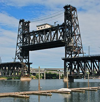
The Steel Bridge is a through truss, double-deck vertical-lift bridge across the Willamette River in Portland, Oregon, United States, opened in 1912. Its lower deck carries railroad and bicycle/pedestrian traffic, while the upper deck carries road traffic, and light rail (MAX), making the bridge one of the most multimodal in the world. It is the only double-deck bridge with independent lifts in the world and the second oldest vertical-lift bridge in North America, after the nearby Hawthorne Bridge. The bridge links the Rose Quarter and Lloyd District in the east to Old Town Chinatown neighborhood in the west.

<span class="mw-page-title-main">Eads Bridge</span> Bridge spanning the Mississippi River in St. Louis, Missouri

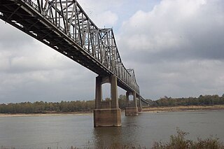
The Eads Bridge is a combined road and railway bridge over the Mississippi River connecting the cities of St. Louis, Missouri, and East St. Louis, Illinois. It is located on the St. Louis riverfront between Laclede's Landing to the north, and the grounds of the Gateway Arch to the south. The bridge is named for its designer and builder, James Buchanan Eads. Work on the bridge began in 1867, and it was completed in 1874. The Eads Bridge was the first bridge across the Mississippi south of the Missouri River. Earlier bridges were located north of the Missouri, where the Mississippi is smaller. None of the earlier bridges survive, which means that the Eads Bridge is also the oldest bridge on the river.

<span class="mw-page-title-main">Bowen Bridge</span> Bridge crossing the Derwent River in Tasmania, Australia

The Bowen Bridge is a segmental cantilever road bridge crossing the River Derwent in Tasmania, Australia. The bridge serves as a vital transportation link in the state capital of Hobart, facilitating the movement of vehicles, pedestrians, and cyclists between the local government areas of Clarence on the eastern shore and Glenorchy on the western shore. The Bowen Bridge links the East Derwent Highway with the Brooker Highway at Glenorchy, approximately 10 kilometres (6.2 mi) from the Hobart city centre.

<span class="mw-page-title-main">Howrah Bridge</span> Steel bridge in Kolkata, India

The Howrah Bridge is a balanced steel bridge over the Hooghly River in West Bengal, India. Commissioned in 1943, the bridge was originally named the New Howrah Bridge, because it replaced a pontoon bridge at the same location linking the twin cities of Howrah and Kolkata, which are located at the opposite banks of each other. On 14 June 1965, it was renamed Rabindra Setu after the Bengali poet Rabindranath Tagore, who was the first Indian and Asian Nobel laureate. It is still popularly known as the Howrah Bridge.

<span class="mw-page-title-main">Huey P. Long Bridge (Jefferson Parish)</span> Road and railroad bridge in Louisiana, U.S.

The Huey P. Long Bridge, located in Jefferson Parish, Louisiana, is a cantilevered steel through-truss bridge that carries a two-track railroad line over the Mississippi River at mile 106.1, with three lanes of US 90 on each side of the central tracks. It is several kilometers upriver from the city of New Orleans. The East Bank entrance is at Elmwood, Louisiana, and the West Bank at Bridge City.

<span class="mw-page-title-main">Walkway over the Hudson</span> Pedestrian bridge in New York, United States of America

The Walkway over the Hudson is a steel cantilever bridge spanning the Hudson River between Poughkeepsie, New York, on the east bank and Highland, New York, on the west bank. Built as a double track railroad bridge, it was completed on January 1, 1889, and formed part of the Maybrook Railroad Line of the New York, New Haven and Hartford Railroad.

<span class="mw-page-title-main">Columbia–Wrightsville Bridge</span> Road and sidewalk overpass in Pennsylvania

The Columbia–Wrightsville Bridge, officially the Veterans Memorial Bridge, spans the Susquehanna River between Columbia and Wrightsville, Pennsylvania, and carries Pennsylvania Route 462 and BicyclePA Route S. Built originally as the Lancaster-York Intercounty Bridge, construction began in 1929, and the bridge opened September 30, 1930. On November 11, 1980, it was officially dedicated as Veterans Memorial Bridge, though it is still referenced locally as the Columbia–Wrightsville Bridge.

<span class="mw-page-title-main">Greenville Bridge</span> Bridge in United States of America

The Greenville Bridge, or the Jesse Brent Memorial Bridge, is a cable-stayed bridge over the Mississippi River, in the United States, carrying US 82 and US 278 between Refuge, Mississippi, and Shives, Arkansas. When it opened in 2010, it was the fourth-longest cable-stayed bridge in North America.

<span class="mw-page-title-main">Benjamin G. Humphreys Bridge</span> Former highway bridge over the Mississippi River

The Benjamin G. Humphreys Bridge was a two-lane cantilevered truss bridge carrying U.S. Route 82/U.S. Route 278 across the Mississippi River between Lake Village, Arkansas and Greenville, Mississippi. It was the first bridge to connect the two towns. The bridge was named for Benjamin G. Humphreys II, a former United States Congressman from Greenville.

<span class="mw-page-title-main">Memphis & Arkansas Bridge</span> Highway bridge in Memphis, Tennessee, United States

The Memphis & Arkansas Bridge, also known as the Memphis–Arkansas Bridge or inaccurately as the Memphis–Arkansas Memorial Bridge, is a cantilevered through truss bridge carrying Interstate 55 across the Mississippi River between West Memphis, Arkansas and Memphis, Tennessee. Memphians refer to this bridge as the "Old Bridge" to distinguish it from the "New Bridge", or Hernando de Soto Bridge, upstream.

<span class="mw-page-title-main">Frisco Bridge</span> Bridge in Arkansas and Memphis, Tennessee

The Frisco Bridge, previously known as the Memphis Bridge, is a cantilevered through truss bridge carrying a rail line across the Mississippi River between West Memphis, Arkansas, and Memphis, Tennessee.

<span class="mw-page-title-main">Hernando de Soto Bridge</span> Steel-arch bridge between West Memphis, Arkansas, and Memphis, Tennessee, US

The Hernando de Soto Bridge is a tied-arch bridge carrying Interstate 40 across the Mississippi River between West Memphis, Arkansas, and Memphis, Tennessee. The design is a continuous cantilevered cable-stayed steel through arch, with bedstead endposts. Memphians also call the bridge the "New Bridge", as it is newer than the Memphis & Arkansas Bridge downstream, and the "M Bridge", due to its distinctive shape. It is of similar construction to the Sherman Minton Bridge between Louisville, Kentucky, and New Albany, Indiana.

<span class="mw-page-title-main">Big Four Bridge</span> Pedestrian bridge that crosses the Ohio River at Louisville, Kentucky

The Big Four Bridge is a six-span former railroad truss bridge that crosses the Ohio River, connecting Louisville, Kentucky, and Jeffersonville, Indiana. It was completed in 1895, updated in 1929, taken out of rail service in 1968, and converted to bicycle and pedestrian use in 2014. The largest single span is 547 feet (167 m), with the entire bridge spanning 2,525 feet (770 m). It took its name from the defunct Cleveland, Cincinnati, Chicago and St. Louis Railway, which was nicknamed the "Big Four Railroad".

<span class="mw-page-title-main">Cairo Rail Bridge</span> Bridge in Kentucky and Cairo, Illinois

Cairo Rail Bridge is the name of two bridges crossing the Ohio River near Cairo, Illinois in the United States. The original was an 1889 George S. Morison through-truss and deck truss bridge, replaced by the current bridge in 1952. The second and current bridge is a through-truss bridge that reused many of the original bridge piers. As of 2018, trains like the City of New Orleans travel over the Ohio River supported by the same piers whose construction began in 1887.

<span class="mw-page-title-main">Kingsferry Bridge</span> Road-rail bridge in Kent, England

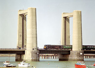
The Kingsferry Bridge is a combined road and railway vertical-lift bridge which connects the Isle of Sheppey to mainland Kent in South East England. The seven-span bridge has a central lifting span which allows ships to pass.

<span class="mw-page-title-main">Interstate 55 in Tennessee</span> Interstate Highway in Tennessee, United States

Interstate 55 (I-55) is part of the Interstate Highway System that runs from LaPlace, Louisiana, to Chicago, Illinois. In the state of Tennessee, the Interstate is located entirely within the state's second-largest city of Memphis, running 12.28 miles (19.76 km) from the Mississippi state line in the Whitehaven neighborhood to the Arkansas border across the Mississippi River. Of the six states that the Interstate passes through, the segment in Tennessee is the shortest, as well as the shortest mainline Interstate segment in Tennessee. I-55 serves a number of neighborhoods and industrial areas in the southwestern portion of Memphis, and also provides access to the Memphis International Airport, the second-busiest cargo airport in the world.

<span class="mw-page-title-main">Lamar Boulevard Bridge</span> Historic bridge in Austin, Texas

The Lamar Boulevard Bridge is a historic arch bridge carrying Texas State Highway Loop 343 over Lady Bird Lake in downtown Austin, Texas, United States. The bridge features six open-spandrel concrete arches spanning 659 feet (201 m) and carries tens of thousands of vehicles daily across the lake. Completed in 1942, the Lamar Boulevard Bridge was the second permanent bridge to cross the Colorado River, and one of the last Art Deco-style open-spandrel concrete arch bridges built in Texas. The bridge was named an Austin Landmark in 1993 and added to the National Register of Historic Places in 1994.

<span class="mw-page-title-main">Transportation in Memphis, Tennessee</span>

Memphis, Tennessee has developed into a major Mid-American commercial and transportation hub because of its location on the Mississippi River and a convergence of numerous rail and highway links. Four rail and highway bridges cross the Mississippi River at Memphis. In addition, Memphis International Airport has become the world's largest airfreight terminal.

<span class="mw-page-title-main">Mississippi River Trail</span> Long-distance bicycle route

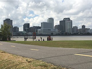
The Mississippi River Trail is a designated bicycle and pedestrian trail that traverses the shores of the Mississippi River in the United States. The trail extends from the headwaters at Lake Itasca in Minnesota to near the mouth of the river in Venice, Louisiana. Much of the trail’s 3,000 miles (4,800 km) follows roadways used by motor vehicles, although some of the route is on multi-use trails. The segment in Minnesota has been designated as U.S. Bicycle Route 45, part of the U.S. Bicycle Route System.

<span class="mw-page-title-main">Forth Bridge</span> Railway bridge over the Firth of Forth in Scotland

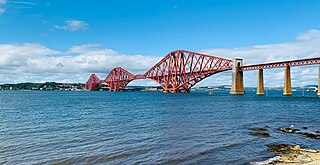
The Forth Bridge is a cantilever railway bridge across the Firth of Forth in the east of Scotland, 9 miles west of central Edinburgh. Completed in 1890, it is considered a symbol of Scotland, and is a UNESCO World Heritage Site. It was designed by English engineers Sir John Fowler and Sir Benjamin Baker. It is sometimes referred to as the Forth Rail Bridge, although this is not its official name.

References

  1. Missouri Department of Transportation (2017). The Merchants Bridge rehabilitation program (PDF) (Grant application). Figure 10: Rail Traffic Volumes Overlaid with Seismic Hazard, 2014.
  2. "Harahan Bridge". Bridge Hunter.
  3. 1 2 3 4 5 6 Modjeski, Ralph (April 16, 1917). Harahan Bridge at Memphis Tn: Final Report.
  4. Shelby County Register of Deeds: Book 0672, Page 466, August 31, 1917
  5. Crittenden County Register of Deeds: Book 97, Page 335, September 10, 1918
  6. "New Bridge Opens", Commercial Appeal, December 18, 1949
  7. "J.T. Harahan Killed in his Private Car" (PDF). New York Times. January 23, 1912.
  8. "Union Pacific Railroad will cooperate in effort to build walkway across Harahan Bridge". Commercial Appeal. February 4, 2011.
  9. 1 2 3 Case, B.M. (March 1915). "New Harahan Bridge Across the Mississippi River at Memphis". Rock Island Employees Magazine via Memphis Historical Railroad Pages.
  10. Charlier, Tom (June 19, 2012). "Memphis gets $14.9M grant to help build pathway across Harahan Bridge". Commercial Appeal. Archived from the original on June 22, 2012.
  11. Scurlock, Stephanie; McCowan, Candace (August 13, 2012). "Bicycler Killed on Interstate Coming From Work". WREG.
  12. Weeks, John A. (2008). "Frisco Bridge; Mississippi River Crossing at Memphis". johnweeks.com.
  13. 1 2 3 4 Magness, Perre (January 22, 1998). "Harahan built to meet Traffic needs". Commercial Appeal.
  14. "Harahan Span costs listed by Arkansas". Commercial Appeal. May 10, 1949.
  15. "The Frisco Bridge". Historic Memphis Bridges.
  16. Sells, Toby. "West Memphis Plans For Big River Crossing". Memphis Flyer. Retrieved January 1, 2016.
  17. Risher, Wayne. "Harahan Bridge lighting has private backers". Commercial Appeal. Retrieved May 21, 2016.