
Riverdale is a residential neighborhood in the northwestern portion of the New York City borough of the Bronx. Riverdale, which had a population of 47,850 as of the 2000 United States Census, contains the city's northernmost point, at the College of Mount Saint Vincent. Riverdale's boundaries are disputed, but it is commonly agreed to be bordered by Yonkers to the north, Van Cortlandt Park and Broadway to the east, the Kingsbridge neighborhood to the southeast, either the Harlem River or the Spuyten Duyvil neighborhood to the south, and the Hudson River to the west. Riverdale Avenue is the primary north–south thoroughfare through Riverdale.
The Harlem River is an 8-mile (13 km) tidal strait in New York, United States, flowing between the Hudson River and the East River and separating the island of Manhattan from the Bronx on the New York mainland.

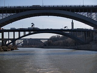
The Henry Hudson Bridge is a steel arch toll bridge in New York City across the Spuyten Duyvil Creek. It connects Spuyten Duyvil in the Bronx with Inwood in Manhattan to the south, via the Henry Hudson Parkway. On the Manhattan side, the parkway goes into Inwood Hill Park. Commercial vehicles are not permitted on this bridge or on the parkway in general.

Spuyten Duyvil station is a commuter rail stop on the Metro-North Railroad's Hudson Line, serving the Spuyten Duyvil neighborhood of the Bronx, New York City.

Spuyten Duyvil Creek is a short tidal estuary in New York City connecting the Hudson River to the Harlem River Ship Canal and then on to the Harlem River. The confluence of the three water bodies separate the island of Manhattan from the Bronx and the rest of the mainland. Once a distinct, turbulent waterway between the Hudson and Harlem rivers, the creek has been subsumed by the modern ship canal.

Spuyten Duyvil is a neighborhood of the Bronx, New York City. It is bounded on the north by Riverdale, on the east by Kingsbridge, on the south by the Harlem River, and on the west by the Hudson River, although some consider it to be the southernmost part of Riverdale.
The North Bronx is the northern section of the Bronx, one of the five boroughs of New York City. It is bordered by Westchester County to the north, the South Bronx to the south, the Hudson River to the west and the Long Island Sound to the east. The western part is more urbanized and hilly than its eastern counterpart, just like the rest of the borough. Despite being recognized as different from the South Bronx, the actual borders of the North Bronx is undefined. One commonly set border is Fordham Road/Pelham Parkway, the upper limit for widespread poverty and arson during the 1970s and 1980s.

The West Side Line, also called the West Side Freight Line, is a railroad line on the west side of the New York City borough of Manhattan. North of Penn Station, from 34th Street, the line is used by Amtrak passenger service heading north via Albany to Toronto; Montreal; Niagara Falls and Buffalo, New York; Burlington, Vermont; and Chicago. South of Penn Station, a 1.45-mile (2.33 km) elevated section of the line, abandoned since 1980, has been transformed into an elevated park called the High Line. The south section of the park from Gansevoort Street to 20th Street opened in 2009 and the second section up to 30th Street opened in 2011, while the final section to 34th Street opened in 2014.

The Hudson Line is a commuter rail line owned and operated by the Metro-North Railroad in the U.S. state of New York. It runs north from New York City along the east shore of the Hudson River, terminating at Poughkeepsie. The line was originally the Hudson River Railroad, and eventually became the Hudson Division of the New York Central Railroad. It runs along what was the far southern leg of the Central's famed "Water Level Route" to Chicago.

The Manhattan Waterfront Greenway is a waterfront greenway for walking or cycling, 32 miles (51 km) long, around the island of Manhattan, in New York City. The largest portions are operated by the New York City Department of Parks and Recreation. It is separated from motor traffic, and many sections also separate pedestrians from cyclists. There are three principal parts — the East, Harlem and Hudson River Greenways.

Norman Finkelstein is an American poet and literary critic. He has written extensively about modern and postmodern poetry and about Jewish American literature. According to Tablet Magazine, Finkelstein's poetry "is simultaneously secular and religious, stately and conversational, prophetic, and circumspect."
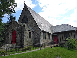
Riverdale Presbyterian Church is a historic Presbyterian church located at 4761-4765 Henry Hudson Parkway in the Riverdale neighborhood of the Bronx, New York City. It was designed in 1863 by architect James Renwick, Jr. The church is a fieldstone building in an English-inspired Late Gothic Revival style. It was substantially enlarged in 1936.
The Riverdale–Spuyten Duyvil–Kingsbridge Memorial Bell Tower or Riverdale Monument is a memorial tower in Bell Tower Park located in the Riverdale section of the Bronx. It was completed on September 17, 1930 to commemorate World War I veterans from the neighborhoods of Riverdale, Spuyten Duyvil, and Kingsbridge. The plaque attached to the memorial lists the names of those Riverdale, Spuyten Duyvil, and Kingsbridge residence who served in World War I. In 1936, it was moved 700 feet south to make room for the Henry Hudson Parkway which it now stands next to. It was listed on the National Register of Historic Places on January 3, 2012.

Spuyten Duyvil and Port Morris Railroad was a railroad built in what is today the West Bronx and South Bronx in New York City, United States. It ran from the junction between the West Side Line and the Hudson River Railroad near Spuyten Duyvil Creek, then along the Harlem River to the northwestern shore of the East River in what is today the Port Morris section of the Bronx.

Muscota Marsh is a one-acre public park in the Inwood section of the borough of Manhattan in New York City, on the shore of Spuyten Duyvil Creek, a section of the Harlem River. It is adjacent to the much larger Inwood Hill Park and Columbia University's Baker Athletics Complex. The park is notable for its views and for its ecological conservation features.
St. Mary's Park is a public park in the Mott Haven neighborhood in the South Bronx section of the Bronx, New York City. The park has sporting facilities and an indoor recreation center.

Tibbetts Brook, originally Tippett's Brook or Tibbitt's Brook, is a stream in the southern portion of mainland New York, flowing north to south from the city of Yonkers in Westchester County into the borough of the Bronx within New York City. Originally emptying into Spuyten Duyvil Creek as part of the Harlem River system, the stream is now partially subterranean, ending above ground at the south end of Van Cortlandt Lake within Van Cortlandt Park. There it proceeds into city sewers, draining into either the northern end of the Harlem River or the Wards Island Water Pollution Control Plant. The brook provides significant watershed to both Van Cortlandt Park at its south end and Tibbetts Brook Park at its north end. There have been modern proposals to daylight the southern portion of the brook back onto the surface.


