Hennepin County is a county in the U.S. state of Minnesota. Its county seat is Minneapolis, the state's most populous city. The county is named in honor of the 17th-century explorer Father Louis Hennepin. The county extends from Minneapolis to the suburbs and outlying cities in the western part of the county. The county’s natural areas are covered with extensive woods, hills, and lakes.

The Villages is a census-designated place (CDP) in Sumter and Marion counties, Florida, United States. It shares its name with a broader master-planned age-restricted community that spreads into portions of Lake County. The overall development lies in central Florida, approximately 20 miles (32 km) south of Ocala and approximately 45 miles (72 km) northwest of Orlando. As of the 2020 census, the population of the CDP was 79,077.

Stansbury Park is a census-designated place (CDP) in Tooele County, Utah, United States. As of the 2020 United States Census, the population was 9,851, up from the 2010 figure of 5,145.
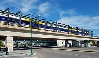
Lake Street/Midtown station, also referred locally as either the Lake Street station or Midtown station, is a Blue Line light rail stop in Minneapolis, Minnesota, United States.

Lake Hiawatha is located just north of Lake Nokomis in Minneapolis, Minnesota. It was purchased by the Minneapolis Park and Recreation Board in 1922 for $550,000. At that time the lake was a marsh known as Rice Lake, but over four years, the park system transformed the wetland into a lake surrounded by a park.

Lake Street is a major east-west thoroughfare between 29th and 31st streets in Minneapolis, Minnesota United States. From its western most end at the city's limits, Lake Street reaches the Chain of Lakes, passing over a small channel linking Bde Maka Ska and Lake of the Isles, and at its eastern most end it reaches the Mississippi River. In May 2020, the Lake Street corridor suffered extensive damage during local unrest over the murder of George Floyd. In August of the same year, city officials designated East Lake Street as one of seven cultural districts to promote racial equity, preserve cultural identity, and promote economic growth.

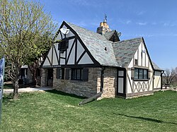
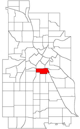
Bancroft is a neighborhood within the Powderhorn community in Minneapolis, Minnesota, United States. Its boundaries are East 38th Street to the north, Chicago Avenue to the west, East 42nd Street to the south and Cedar Avenue to the east.

Lake Needwood is a 75-acre (300,000 m2) reservoir in Derwood, Maryland, United States. Located east of Rockville, in the eastern part of Montgomery County, it is situated on Rock Creek. The lake was created by damming Rock Creek in 1965 with the goal of providing flood control and reducing soil erosion. Lake Needwood also protects the water quality of the creek by functioning as a retention basin to trap sediment from storm-water runoff.
Ventura Village is a neighborhood within the Phillips community in Minneapolis. Its boundaries are Interstate 35W to the west, Interstate 94 to the north, and Hiawatha Avenue to the east. The southern boundary runs along East 22nd Street from I-35W to Chicago Avenue, along East 24th Street from Chicago Avenue to 17th Avenue South, and then back up to 22nd Street from 17th Avenue to Hiawatha Avenue. Franklin Avenue, which runs east-west, acts as the main commercial artery in the neighborhood.

Nokomis East is a group of neighborhoods in the southeastern corner of Minneapolis, Minnesota, United States. It consists of four neighborhoods: Keewaydin, Minnehaha, Morris Park and Wenonah. Nokomis East contains two schools, the Nokomis Community Library, and a post office. On its western edge is Lake Nokomis, for which it is named. Two regional parks, and three neighborhood parks, provide recreation and educational programming for all age groups. Seven churches serve residents of various denominations. Nokomis East is served by the Nokomis East Neighborhood Association (NENA). The main transportation corridors are the neighborhood boundaries: Cedar Avenue, 34th and 28th Avenues, 50th and 54th Streets, Hwy 55, and Crosstown highway 62.

Lake Phalen is an urban lake located in Saint Paul, Minnesota and in its suburb of Maplewood. It is one of the largest lakes in Saint Paul and is the centerpiece of the Phalen Regional Park System. The lake drains into the Mississippi River after traveling through Phalen Creek. The lake and surrounding 494-acre (2.00 km2) park receive around 500,000 visitors each year.
Fishing Lake is a closed basin freshwater lake in the Canadian province of Saskatchewan. The lake is 22 kilometres (14 mi) north of the town of Foam Lake, and 24 kilometres (15 mi) east of the town of Wadena and is accessed from Highways 5 and 310. The northern and eastern shore is in the RM of Sasman No. 336 and the southern and western shore is in the RM of Foam Lake No. 276. The north-east portion of the lake–on the east side of McCormick Bay–is designated as Fishing Lake Wildlife Refuge.
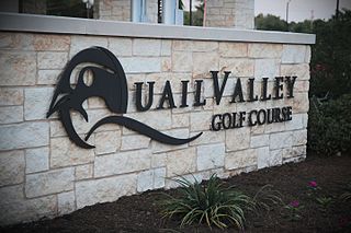
Quail Valley is a neighborhood dating from 1969 of Missouri City, in Fort Bend County, Texas, United States.

Deerwood was the first gated community in Florida, US. After it was established in the mid-1960s, it was the most exclusive residential area on Jacksonville's Southside. The golf course hosted the Greater Jacksonville Open in the late 1960s and early 1970s, forerunner of The Players Championship, and was once the site of talks between President Gerald Ford and Egyptian President Anwar Sadat in November 1975.

Langston Golf Course is an 18-hole golf course in Washington, D.C., established in 1939. It was named for John Mercer Langston, an African American who was the first dean of the Howard University School of Law, the first president of Virginia Normal and Collegiate Institute, and the first African American elected to the United States Congressas a Republican from Virginia. It was the second racially desegregated golf course in the District of Columbia, and in 1991 its first nine holes were added to the National Register of Historic Places.
The Minneapolis Park and Recreation Board (MPRB) is an independent park district that owns, maintains, and programs activities in public parks in Minneapolis, Minnesota, United States. It has 500 full-time and 1,300 part-time employees and an $111 million operating and capital budget.

Minneapolis is often considered one of the top biking and walking cities in the United States due to its vast network of trails and dedicated pedestrian areas. In 2020, Walk Score rated Minneapolis as 13th highest among cities over 200,000 people. Some bicycling ratings list Minneapolis at the top of all United States cities, while others list Minneapolis in the top ten. There are over 80 miles (130 km) of paved, protected pathways in Minneapolis for use as transportation and recreation. The city's Grand Rounds National Scenic Byway parkway system accounts for the vast majority of the city's shared-use paths at approximately 50 miles (80 km) of dedicated biking and walking areas. By 2008, other city, county, and park board areas accounted for approximately 30 miles (48 km) of additional trails, for a city-wide total of approximately 80 miles (130 km) of protected pathways. The network of shared biking and walking paths continued to grow into the late 2010s with the additions of the Hiawatha LRT Trail gap remediation, Min Hi Line pilot projects, and Samatar Crossing. The city also features several natural-surface hiking trails, mountain-biking paths, groomed cross-country ski trails in winter, and other pedestrian walkways.

The U.S. city of Minneapolis featured officially and unofficially designated camp sites in city parks for people experiencing homelessness that operated from June 10, 2020, to January 7, 2021. The emergence of encampments on public property in Minneapolis was the result of pervasive homelessness, mitigations measures related to the COVID-19 pandemic in Minnesota, local unrest after the murder of George Floyd, and local policies that permitted encampments. At its peak in the summer of 2020, there were thousands of people camping at dozens of park sites across the city. Many of the encampment residents came from outside of Minneapolis to live in the parks. By the end of the permit experiment, four people had died in the city's park encampments, including the city's first homicide victim of 2021, who was stabbed to death inside a tent at Minnehaha Park on January 3, 2021.

John Cheatham (1855–1918) was an American firefighter in Minneapolis during the late 1800s and early 1900s. Born under slavery in St. Louis, Missouri, Cheatham was freed at the age of eight by the Emancipation Proclamation, and then moved to Minneapolis, Minnesota, with his family shortly thereafter. In 1883, at the age of 33, Cheatham was appointed as one of the first Black firefighters in Minneapolis. He held several leadership positions during his fire department career. In 2022, the City of Minneapolis re-designated a street in the Longfellow community as Cheatham Avenue to honor his legacy of racial integration within the city’s fire department.