The Jurassic is a geologic period and stratigraphic system that spanned from the end of the Triassic Period 201.4 million years ago (Mya) to the beginning of the Cretaceous Period, approximately 145 Mya. The Jurassic constitutes the middle period of the Mesozoic Era and is named after the Jura Mountains, where limestone strata from the period were first identified.

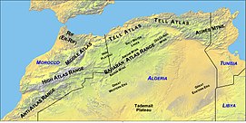
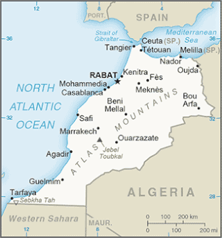
The Atlas Mountains are a mountain range in the Maghreb in North Africa. It separates the Sahara Desert from the Mediterranean Sea and the Atlantic Ocean; the name "Atlantic" is derived from the mountain range, which stretches around 2,500 km (1,600 mi) through Morocco, Algeria and Tunisia. The range's highest peak is Toubkal, which is in central Morocco, with an elevation of 4,167 metres (13,671 ft). The Atlas mountains are primarily inhabited by Berber populations.

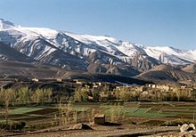
Tazoudasaurus is a genus of gravisaurian, probably a vulcanodontid sauropod dinosaurs hailing from the late Early Jurassic (Toarcian), that was recovered in the "Toundoute Continental Series" located in the High Atlas Mountains of Morocco in North Africa. Along with Patagosaurus, Volkheimeria, Bagualia and Perijasaurus represents one of the few sauropods named from this stage on Gondwana, as well the only one from Africa.
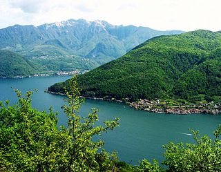
Monte San Giorgio is a Swiss mountain and UNESCO World Heritage Site near the border between Switzerland and Italy. It is part of the Lugano Prealps, overlooking Lake Lugano in the Swiss Canton of Ticino.

Berberosaurus is a genus of neotheropod dinosaur, possibly a ceratosaur, from the Toarcian-age "Toundoute Continental Series" found in the Central High Atlas of Toundoute, Ouarzazate, Morocco. The type species of the genus Berberosaurus is B. liassicus, in reference to the Lias epoch. Berberosaurus might be the oldest known ceratosaur, and is based on partial postcranial remains. This genus represents the oldest formally identified theropod from the North of Africa, as well one of the few from the region in the Early Jurassic.

The geology of the Iberian Peninsula consists of the study of the rock formations on the Iberian Peninsula, which includes Spain, Portugal, Andorra, and Gibraltar. The peninsula contains rocks from every geological period from the Ediacaran to the Quaternary, and many types of rock are represented. World-class mineral deposits are also found there.
The Aquitaine Basin is the second largest Mesozoic and Cenozoic sedimentary basin in France after the Paris Basin, occupying a large part of the country's southwestern quadrant. Its surface area covers 66,000 km2 onshore. It formed on Variscan basement which was peneplained during the Permian and then started subsiding in the early Triassic. The basement is covered in the Parentis Basin and in the Subpyrenean Basin—both sub-basins of the main Aquitaine Basin—by 11,000 m of sediment.
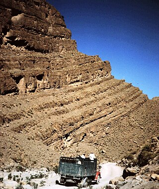
The Aganane Formation is a Pliensbachian geologic formation in the Azilal, Béni-Mellal, Ouarzazate, Tinerhir and Errachidia provinces, central Morocco, being the remnant of a local massive Carbonate platform, and known mostly for its rich tracksites including footprints of thyreophoran, sauropod and theropod dinosaurs. This formation has been dated to the Pliensbachian stage of the Lower Jurassic, thanks to the find of the ammonite Arieticeras cf. algovianum, indicator of Middle Domerian in the upper zone, and lower delimitation by the foraminifers Mayncina termieri and Orbitopsella praecursor. The dinosaur tracksites are all located a few metres below the Pliensbachian-Toarcian limit, being coeval and connected with the lowermost layers of the continental Azilal Formation. The Aganane Formation was also coeval with the Jbel Taguendouft Formation and the Tamadout 1 Formation, all developed along a local "platform-furrow" in the Middle Atlas Mountains, that act as a barrier controlling the western border of the Jurassic Atlas Gulf. The nearshore sections, including both carbonate platforms and close to sea terrestrial facies where located on an isolated internal domain thanks to the control of the barrier, allowing the Aganane Formation to develop on a hot and humid climate, where a local algal marsh had intermittent progradations, intercalated with a layer of terrigenous continental origin. The ichnosites were developed in tidal flats and coastal deposits suitable to sea flooding.

The geology of Germany is heavily influenced by several phases of orogeny in the Paleozoic and the Cenozoic, by sedimentation in shelf seas and epicontinental seas and on plains in the Permian and Mesozoic as well as by the Quaternary glaciations.
The Tarfaya Basin is a structural basin located in southern Morocco that extends westward into the Moroccan territorial waters in the Atlantic Ocean. The basin is named for the city of Tarfaya located near the border of Western Sahara, a region governed by the Kingdom of Morocco. The Canary Islands form the western edge of the basin and lie approximately 100 km to the west.

The Drzewica Formation is a geologic formation in Szydłowiec, Poland. It is Pliensbachian in age. Vertebrate fossils have been uncovered from this formation, including dinosaur tracks. The Drzewica Formation is part of the Depositional sequence IV-VII of the late lower Jurassic Polish Basin, with the IV showing the presence of local Alluvial deposits, with possible meandriform deposition origin, dominated in Jagodne and Szydłowiec, while delta system occurred through the zone of the modern Budki. The sequence V shows a reduction of the erosion in the Zychorzyn borehole of the Drzewica Formation, showing changes on the extension of the marine facies, where upper deposits change from Alluvial to Deltaic-Seashore depositional settings. VI-VII facies were recovered on the Brody-Lubienia borehole, with a lower part exposed on the village of Śmiłów that shows a small fall of the Sea level. The stathigraphic setting of the dinosaur tracks reported from the formation suggest a Seashore or Deltaic barrier. Body fossils reported include bivalves, palynology, fossil trunks, roots. Trunks of coniferous wood, especially Cheirolepidiaceae and Araucariaceae trees show the occurrence of vast coniferous forests around the tracksite. The association of forests and dinosaur megafauna on the Pliensbachian suggests also a colder and specially dry ecosystem. Drzewica deposits where in part to be a gigantic shore barrel, setting at the time where the Polish basin sea was at its lowest point. Other related units are Fjerritslev or Gassum Formation, Hasle & Sorthat Formation (Bornholm), upper Neringa Formation (Lithuania) and abandoned informal units in other regions of Poland: upper Sawêcin beds, Wieluñ series or Bronów series.
The geology of Morocco formed beginning up to two billion years ago, in the Paleoproterozoic and potentially even earlier. It was affected by the Pan-African orogeny, although the later Hercynian orogeny produced fewer changes and left the Maseta Domain, a large area of remnant Paleozoic massifs. During the Paleozoic, extensive sedimentary deposits preserved marine fossils. Throughout the Mesozoic, the rifting apart of Pangaea to form the Atlantic Ocean created basins and fault blocks, which were blanketed in terrestrial and marine sediments—particularly as a major marine transgression flooded much of the region. In the Cenozoic, a microcontinent covered in sedimentary rocks from the Triassic and Cretaceous collided with northern Morocco, forming the Rif region. Morocco has extensive phosphate and salt reserves, as well as resources such as lead, zinc, copper and silver.

The geology of Bulgaria consists of two major structural features. The Rhodope Massif in southern Bulgaria is made up of Archean, Proterozoic and Cambrian rocks and is a sub-province of the Thracian-Anatolian polymetallic province. It has dropped down, faulted basins filled with Cenozoic sediments and volcanic rocks. The Moesian Platform to the north extends into Romania and has Paleozoic rocks covered by rocks from the Mesozoic, typically buried by thick Danube River valley Quaternary sediments. In places, the Moesian Platform has small oil and gas fields. Bulgaria is a country in southeastern Europe. It is bordered by Romania to the north, Serbia and North Macedonia to the west, Greece and Turkey to the south, and the Black Sea to the east.

The Budoš Limestone is a geological formation in Montenegro, dating to 180 million years ago, and covering the Toarcian stage of the Jurassic Period. It has been considered an important setting in Balkan paleontology, as it represents a unique terrestrial setting with abundant plant material, one of the few know from the Toarcian of Europe. It is the regional equivalent to the Toarcian units of Spain such as the Turmiel Formation, units like the Azilal Formation of Morocco and others from the Mediterranean such as the Posidonia Beds of Greece and the Marne di Monte Serrone of Italy. In the Adriatic section, this unit is an equivalent of the Calcare di Sogno of north Italy, as well represents almost the same type of ecosystem recovered in the older (Pliensbachian) Rotzo Formation of the Venetian region, know also for its rich floral record.

The Krempachy Marl Formation is a geological formation in Poland and Slovakia, dating to about 179 million years ago, and covering the middle Toarcian stage of the Jurassic Period. It is among the most important formations of the Toarcian boundary on the Carpathian realm, being the regional equivalent of the Posidonia Shale.
The Sorthat Formation is a geologic formation on the island of Bornholm, Denmark and in the Rønne Graben in the Baltic Sea. It is of Latest Pliensbachian to Late Toarcian age. Plant fossils have been recovered from the formation, along with several traces of invertebrate animals. The Sorthat Formation is overlain by fluvial to lacustrine gravels, along with sands, clay and in some places coal beds that are part of the Aalenian-Bathonian Bagå Formation. Until 2003, the Sorthat Formation was included as the lowermost part of the Bagå Formation, recovering the latest Pliensbachian to lower Aalenian boundary. The Sorthat strata reflect a mostly marginally deltaic to marine unit. Large streams fluctuated to the east, where a large river system was established at the start of the Toarcian. In the northwest, local volcanism that started in the lower Pliensbachian extended along the North Sea, mostly from southern Sweden. At this time, the Central Skåne Volcanic Province and the Egersund Basin expelled most of their material, with influences on the local tectonics. The Egersund Basin has abundant fresh porphyritic nephelinite lavas and dykes of lower Jurassic age, with a composition nearly identical to those found in the clay pits. That indicates the transport of strata from the continental margin by large fluvial channels of the Sorthat and the connected Röddinge Formation that ended in the sea deposits of the Ciechocinek Formation green series.
The Rya Formation is a geologic formation in Skåne County, southern Sweden. It is Early to early Middle Jurassic in age. The Rya Formation comprises siltstones, claystones, sandstones, mudstones and rare coal beds. The formation overlies the Höganäs Formation and is overlain by the Vilhelmsfält and Mariedal Formations.

The Úrkút Manganese Ore Formation is a Jurassic geologic formation in Hungary. It covers the Early Toarcian stage of the Early Jurassic, and it is one of the main regional units linked to the Toarcian Anoxic Events. Different fossils heve been recovered on the locations, including marine life such as Ammonites Fish and terrestrial fossils, such as Palynomorphs and fossil wood. Úrkút and Eplény are the main deposits of the Formation. Are related to the Bakony Range, an ancient massif that was uplifted gradually and exposed to a long period of erosion, where the deposits of Úrkút appear to be a basin inclined gently to the north, while the highest point to the south is the basalt mass of Kab Mountain. Eplény region consists of a broad N-S trending open valley between fiat-topped, small hills.

Orthophlebiidae is an extinct family of scorpionflies known from the Triassic to Cretaceous, belonging to the superfamily Panorpoidea. The family is poorly defined and is probably paraphyletic, representing many primitive members of Panorpoidea with most species only known from isolated wings, and has such been considered a wastebasket taxon.

The Tafraout Group is a geological group of formations of Toarcian-Aalenian age in the Azilal, Béni-Mellal, Imilchil, Zaouiat Ahansal, Ouarzazate, Tinerhir and Errachidia areas of the High Atlas of Morocco. The Group represents the remnants of a local massive Siliciclastic-Carbonate platform, best assigned to succession W-E of alluvial environment occasionally interrupted by shallow marine incursions and inner platform to open marine settings, and marks a dramatic decrease of the carbonate productivity under increasing terrigenous sedimentation. Fossils include large reef biotas with richness in "lithiotid" bivalves and coral mounts, but also by remains of vertebrates such as the sauropod Tazoudasaurus and the basal ceratosaur Berberosaurus, along with several undescribed genera. While there have been attributions of its lowermost layers to the Latest Pliensbachian, the current oldest properly measured are part of the Earliest Toarcian regression ("MRST10"), part of the Lower-Middle Palymorphum biozone. This group is composed of the following units, which extend from west to east: the Azilal Formation ; the Amezraï Formation ; the Aguerd-nˈTazoult Formation ; the Tagoudite Formation & the Trafraout Formation. They are connected with the offshore Ait Athmane Formation and the deeper shelf deposits of the Agoudim 1 Formation. Overall, this group represents a mixed carbonate-siliciclastic system of several hundred meters thick, dominated by deposits of shallow marine platforms linked to a nearby hinterland dominated by conglomerates. The strata of the group extend towards the central High Atlas, covering different anticlines and topographic features along the mountain range.