Alpine climate is the typical climate for elevations above the tree line, where trees fail to grow due to cold. This climate is also referred to as a mountain climate or highland climate.
Alpine climate is the typical climate for elevations above the tree line, where trees fail to grow due to cold. This climate is also referred to as a mountain climate or highland climate.
There are multiple definitions of alpine climate.
In the Köppen climate classification, the alpine and mountain climates are part of group E, along with the polar climate, where no month has a mean temperature higher than 10 °C (50 °F). [1]
According to the Holdridge life zone system, there are two mountain climates which prevent tree growth :
a) the alpine climate, which occurs when the mean biotemperature of a location is between 1.5 and 3 °C (34.7 and 37.4 °F). The alpine climate in Holdridge system is roughly equivalent to the warmest tundra climates (ET) in the Köppen system.
b) the alvar climate, the coldest mountain climate since the biotemperature is between 0 °C and 1.5 °C (biotemperature can never be below 0 °C). It corresponds more or less to the coldest tundra climates and to the ice cap climates (EF) as well.
Holdrige reasoned that plants net primary productivity ceases with plants becoming dormant at temperatures below 0 °C (32 °F) and above 30 °C (86 °F). [2] Therefore, he defined biotemperature as the mean of all temperatures but with all temperatures below freezing and above 30 °C adjusted to 0 °C; that is, the sum of temperatures not adjusted is divided by the number of all temperatures (including both adjusted and non-adjusted ones).
The variability of the alpine climate throughout the year depends on the latitude of the location. For tropical oceanic locations, such as the summit of Mauna Loa, the temperature is roughly constant throughout the year. [3] For mid-latitude locations, such as Mount Washington in New Hampshire, the temperature varies seasonally, but never gets very warm. [4] [5]
The temperature profile of the atmosphere is a result of an interaction between radiation and convection. Sunlight in the visible spectrum hits the ground and heats it. The ground then heats the air at the surface. If radiation were the only way to transfer heat from the ground to space, the greenhouse effect of gases in the atmosphere would keep the ground at roughly 333 K (60 °C; 140 °F), and the temperature would decay exponentially with height. [6]
However, when air is hot, it tends to expand, which lowers its density. Thus, hot air tends to rise and transfer heat upward. This is the process of convection. Convection comes to equilibrium when a parcel of air at a given altitude has the same density as its surroundings. Air is a poor conductor of heat, so a parcel of air will rise and fall without exchanging heat. This is known as an adiabatic process, which has a characteristic pressure-temperature curve. As the pressure gets lower, the temperature decreases. The rate of decrease of temperature with elevation is known as the adiabatic lapse rate, which is approximately 9.8 °C per kilometer (or 5.4 °F per 1000 feet) of altitude. [6]
The presence of water in the atmosphere complicates the process of convection. Water vapor contains latent heat of vaporization. As air rises and cools, it eventually becomes saturated and cannot hold its quantity of water vapor. The water vapor condenses (forming clouds), and releases heat, which changes the lapse rate from the dry adiabatic lapse rate to the moist adiabatic lapse rate (5.5 °C per kilometre or 3 °F per 1000 feet). [7] The actual lapse rate, called the environmental lapse rate, is not constant (it can fluctuate throughout the day or seasonally and also regionally), but a normal lapse rate is 5.5 °C per 1,000 m (3.57 °F per 1,000 ft). [8] [9] Therefore, moving up 100 metres (330 ft) on a mountain is roughly equivalent to moving 80 kilometres (50 miles or 0.75° of latitude) towards the pole. [10] This relationship is only approximate, however, since local factors, such as proximity to oceans, can drastically modify the climate. [11] As the altitude increases, the main form of precipitation becomes snow and the winds increase. The temperature continues to drop until the tropopause, at 11,000 metres (36,000 ft), where it does not decrease further. This is higher than the highest summit.
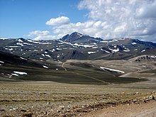
Although this climate classification only covers a small portion of the Earth's surface, alpine climates are widely distributed. They are present in the Himalayas, the Tibetan Plateau, Gansu, Qinghai and Mount Lebanon [12] in Asia, the Alps, the Urals, the Pyrenees, the Cantabrian Mountains and the Sierra Nevada in Europe, the Andes in South America, the Sierra Nevada, the Cascade Mountains, the Rocky Mountains, the northern Appalachian Mountains (Adirondacks and White Mountains), and the Trans-Mexican volcanic belt in North America, the Southern Alps in New Zealand, the Snowy Mountains in Australia, high elevations in the Atlas Mountains, Ethiopian Highlands, and the Eastern Highlands of Africa, and the central parts of Borneo and New Guinea and the summits of Mount Pico in the Atlantic [13] and Mauna Loa in the Pacific.
The lowest altitude of alpine climate varies dramatically by latitude. If alpine climate is defined by the tree line, then it occurs as low as 650 metres (2,130 ft) at 68°N in Sweden, [14] while on Mount Kilimanjaro in Tanzania, the tree line is at 3,950 metres (12,960 ft). [14]
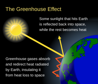
The greenhouse effect occurs when greenhouse gases in a planet's atmosphere insulate the planet from losing heat to space, raising its surface temperature. Surface heating can happen from an internal heat source as in the case of Jupiter, or from its host star as in the case of the Earth. In the case of Earth, the Sun emits shortwave radiation (sunlight) that passes through greenhouse gases to heat the Earth's surface. In response, the Earth's surface emits longwave radiation (heat) that is mostly absorbed by greenhouse gases. That heat absorption reduces the rate at which the Earth can cool off in response to being warmed by the Sun. Adding to greenhouse gases further reduces the rate a planet emits radiation to space, raising its average surface temperature.

A mountain is an elevated portion of the Earth's crust, generally with steep sides that show significant exposed bedrock. Although definitions vary, a mountain may differ from a plateau in having a limited summit area, and is usually higher than a hill, typically rising at least 300 metres (980 ft) above the surrounding land. A few mountains are isolated summits, but most occur in mountain ranges.

The troposphere is the lowest layer of the atmosphere of Earth. It contains 80% of the total mass of the planetary atmosphere and 99% of the total mass of water vapor and aerosols, and is where most weather phenomena occur. From the planetary surface of the Earth, the average height of the troposphere is 18 km in the tropics; 17 km in the middle latitudes; and 6 km in the high latitudes of the polar regions in winter; thus the average height of the troposphere is 13 km.
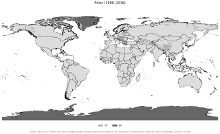
The polar climate regions are characterized by a lack of warm summers but with varying winters. Every month a polar climate has an average temperature of less than 10 °C (50 °F). Regions with a polar climate cover more than 20% of the Earth's area. Most of these regions are far from the equator and near the poles, and in this case, winter days are extremely short and summer days are extremely long. A polar climate consists of cool summers and very cold winters, which results in treeless tundra, glaciers, or a permanent or semi-permanent layer of ice. It is identified with the letter E in the Köppen climate classification.
Altitude is a distance measurement, usually in the vertical or "up" direction, between a reference datum and a point or object. The exact definition and reference datum varies according to the context. Although the term altitude is commonly used to mean the height above sea level of a location, in geography the term elevation is often preferred for this usage.

The tropopause is the atmospheric boundary that demarcates the troposphere from the stratosphere, which are the lowest two of the five layers of the atmosphere of Earth. The tropopause is a thermodynamic gradient-stratification layer that marks the end of the troposphere, and is approximately 17 kilometres (11 mi) above the equatorial regions, and approximately 9 kilometres (5.6 mi) above the polar regions.

Alpine tundra is a type of natural region or biome that does not contain trees because it is at high elevation, with an associated harsh climate. As the latitude of a location approaches the poles, the threshold elevation for alpine tundra gets lower until it reaches sea level, and alpine tundra merges with polar tundra.

The lapse rate is the rate at which an atmospheric variable, normally temperature in Earth's atmosphere, falls with altitude. Lapse rate arises from the word lapse, in the sense of a gradual fall. In dry air, the adiabatic lapse rate is 9.8 °C/km. The saturated adiabatic lapse rate (SALR), or moist adiabatic lapse rate (MALR), is the decrease in temperature of a parcel of water-saturated air that rises in the atmosphere. It varies with the temperature and pressure of the parcel and is often in the range 3.6 to 9.2 °C/km, as obtained from the International Civil Aviation Organization (ICAO). The environmental lapse rate is the decrease in temperature of air with altitude for a specific time and place. It can be highly variable between circumstances.
Equivalent potential temperature, commonly referred to as theta-e, is a quantity that is conserved during changes to an air parcel's pressure, even if water vapor condenses during that pressure change. It is therefore more conserved than the ordinary potential temperature, which remains constant only for unsaturated vertical motions.

The International Standard Atmosphere (ISA) is a static atmospheric model of how the pressure, temperature, density, and viscosity of the Earth's atmosphere change over a wide range of altitudes or elevations. It has been established to provide a common reference for temperature and pressure and consists of tables of values at various altitudes, plus some formulas by which those values were derived. The International Organization for Standardization (ISO) publishes the ISA as an international standard, ISO 2533:1975. Other standards organizations, such as the International Civil Aviation Organization (ICAO) and the United States Government, publish extensions or subsets of the same atmospheric model under their own standards-making authority.
The life zone concept was developed by C. Hart Merriam in 1889 as a means of describing areas with similar plant and animal communities. Merriam observed that the changes in these communities with an increase in latitude at a constant elevation are similar to the changes seen with an increase in elevation at a constant latitude.
In meteorology, convective instability or stability of an air mass refers to its ability to resist vertical motion. A stable atmosphere makes vertical movement difficult, and small vertical disturbances dampen out and disappear. In an unstable atmosphere, vertical air movements tend to become larger, resulting in turbulent airflow and convective activity. Instability can lead to significant turbulence, extensive vertical clouds, and severe weather such as thunderstorms.
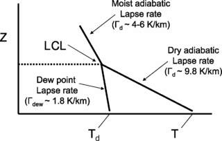
The lifted condensation level or lifting condensation level (LCL) is formally defined as the height at which the relative humidity (RH) of an air parcel will reach 100% with respect to liquid water when it is cooled by dry adiabatic lifting. The RH of air increases when it is cooled, since the amount of water vapor in the air remains constant, while the saturation vapor pressure decreases almost exponentially with decreasing temperature. If the air parcel is lifting further beyond the LCL, water vapor in the air parcel will begin condensing, forming cloud droplets. The LCL is a good approximation of the height of the cloud base which will be observed on days when air is lifted mechanically from the surface to the cloud base.
Atmospheric thermodynamics is the study of heat-to-work transformations that take place in the Earth's atmosphere and manifest as weather or climate. Atmospheric thermodynamics use the laws of classical thermodynamics, to describe and explain such phenomena as the properties of moist air, the formation of clouds, atmospheric convection, boundary layer meteorology, and vertical instabilities in the atmosphere. Atmospheric thermodynamic diagrams are used as tools in the forecasting of storm development. Atmospheric thermodynamics forms a basis for cloud microphysics and convection parameterizations used in numerical weather models and is used in many climate considerations, including convective-equilibrium climate models.
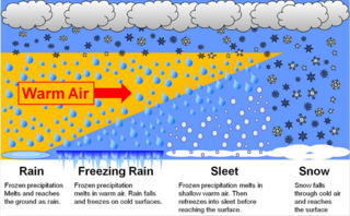
In meteorology, the different types of precipitation often include the character, formation, or phase of the precipitation which is falling to ground level. There are three distinct ways that precipitation can occur. Convective precipitation is generally more intense, and of shorter duration, than stratiform precipitation. Orographic precipitation occurs when moist air is forced upwards over rising terrain and condenses on the slope, such as a mountain.
The convective condensation level (CCL) represents the height where an air parcel becomes saturated when heated from below and lifted adiabatically due to buoyancy.
Atmospheric instability is a condition where the Earth's atmosphere is considered to be unstable and as a result local weather is highly variable through distance and time. Atmospheric stability is a measure of the atmosphere's tendency to discourage vertical motion, and vertical motion is directly correlated to different types of weather systems and their severity. In unstable conditions, a lifted thing, such as a parcel of air will be warmer than the surrounding air. Because it is warmer, it is less dense and is prone to further ascent.

Montane ecosystems are found on the slopes of mountains. The alpine climate in these regions strongly affects the ecosystem because temperatures fall as elevation increases, causing the ecosystem to stratify. This stratification is a crucial factor in shaping plant community, biodiversity, metabolic processes and ecosystem dynamics for montane ecosystems. Dense montane forests are common at moderate elevations, due to moderate temperatures and high rainfall. At higher elevations, the climate is harsher, with lower temperatures and higher winds, preventing the growth of trees and causing the plant community to transition to montane grasslands and shrublands or alpine tundra. Due to the unique climate conditions of montane ecosystems, they contain increased numbers of endemic species. Montane ecosystems also exhibit variation in ecosystem services, which include carbon storage and water supply.
Representations of the atmospheric boundary layer in global climate models play a role in simulations of past, present, and future climates. Representing the atmospheric boundary layer (ABL) within global climate models (GCMs) are difficult due to differences in surface type, scale mismatch between physical processes affecting the ABL and scales at which GCMs are run, and difficulties in measuring different physical processes within the ABL. Various parameterization techniques described below attempt to address the difficulty in ABL representations within GCMs.

This glossary of meteorology is a list of terms and concepts relevant to meteorology and atmospheric science, their sub-disciplines, and related fields.