Climate of the Alps

Last updated
Life zones of the Alps Altitudinal zones of Alps mountains-extended diagram.svg
Life zones of the Alps

The climate of the Alps is the climate, or average weather conditions over a long period of time, of the exact middle Alpine region of Europe. [1] [2] As air rises from sea level to the upper regions of the atmosphere the temperature decreases. The effect of mountain topography on prevailing winds is to force warm air from the lower region into an upper zone where it expands in volume at the cost of a proportionate loss of heat, often accompanied by the precipitation of moisture in the form of snow, rain or hail.

Climate as a function of elevation

Because air cools as it rises, the climate of the Alps is strongly dependent on the elevation. The Alps contain a number of different kinds of climate zones, by elevation. These zones can be described by the Köppen climate classification, and also correspond to the biotic zones of the Alps. [3]

Up to approximately 1,050 metres (3,440 ft) of elevation, the climate is classified as oceanic or Cfb under the Köppen system. [3] Like much of lowland northern Europe, the summers are mild and the winters are cool, but not cold. The climate is moderated by proximity to the Atlantic Ocean. The climate creates the colline biotic zone in the lowlands, which is characterized by the deciduous forest [3] of the Western European broadleaf forests ecoregion.

Climate data for Buchs/Aarau (1991–2020), at 387 metres (1,270 ft), 47°23′N8°05′E / 47.38°N 8.08°E / 47.38; 8.08 (Buchs, Aargau)
MonthJanFebMarAprMayJunJulAugSepOctNovDecYear
Mean daily maximum °C (°F)3.9
(39.0)
5.9
(42.6)
11.1
(52.0)
15.6
(60.1)
19.6
(67.3)
23.5
(74.3)
25.6
(78.1)
25.0
(77.0)
20.2
(68.4)
14.5
(58.1)
8.0
(46.4)
4.3
(39.7)
14.8
(58.6)
Daily mean °C (°F)1.2
(34.2)
1.9
(35.4)
5.9
(42.6)
9.9
(49.8)
14.0
(57.2)
17.7
(63.9)
19.4
(66.9)
18.8
(65.8)
14.6
(58.3)
10.1
(50.2)
5.0
(41.0)
1.9
(35.4)
10.0
(50.0)
Mean daily minimum °C (°F)−1.5
(29.3)
−1.7
(28.9)
1.2
(34.2)
4.3
(39.7)
8.5
(47.3)
12.1
(53.8)
13.6
(56.5)
13.5
(56.3)
9.8
(49.6)
6.5
(43.7)
2.3
(36.1)
−0.5
(31.1)
5.7
(42.3)
Average precipitation mm (inches)63
(2.5)
53
(2.1)
61
(2.4)
63
(2.5)
98
(3.9)
92
(3.6)
98
(3.9)
98
(3.9)
70
(2.8)
72
(2.8)
69
(2.7)
81
(3.2)
920
(36.2)
Average snowfall cm (inches)8
(3.1)
9
(3.5)
3
(1.2)
0.
(0)
0
(0)
0
(0)
0
(0)
0
(0)
0
(0)
0
(0)
2
(0.8)
10
(3.9)
32
(13)
Average precipitation days (≥ 1.0 mm)9.68.69.510.211.611.310.911.28.510.19.811.6122.9
Average snowy days (≥ 1.0 cm)2.82.51.10.1000000.10.72.49.7
Source: MeteoSwiss [4]

Between approximately 1,050 to 1,390 metres (3,440 to 4,560 ft), the climate changes to either a humid continental climate (Dfb under the Köppen system), or a Cfc oceanic climate, depending on location. [3] As elevation increases, the winters become colder and the summers become shorter. A mixture of conifer and deciduous trees occupy this montane zone, [3] leading to a change in ecoregion to Alps conifer and mixed forests.

Climate data for Scuol (1991–2020), 1,304 metres (4,278 ft), 46°47′N10°17′E / 46.79°N 10.28°E / 46.79; 10.28
MonthJanFebMarAprMayJunJulAugSepOctNovDecYear
Mean daily maximum °C (°F)0.0
(32.0)
2.9
(37.2)
8.7
(47.7)
13.0
(55.4)
17.1
(62.8)
21.1
(70.0)
23.1
(73.6)
22.6
(72.7)
18.1
(64.6)
13.2
(55.8)
5.8
(42.4)
0.3
(32.5)
12.2
(54.0)
Daily mean °C (°F)−4.3
(24.3)
−2.7
(27.1)
1.8
(35.2)
6.0
(42.8)
10.3
(50.5)
13.8
(56.8)
15.5
(59.9)
15.0
(59.0)
11.0
(51.8)
6.5
(43.7)
0.9
(33.6)
−3.3
(26.1)
5.9
(42.6)
Mean daily minimum °C (°F)−8
(18)
−7.3
(18.9)
−3.5
(25.7)
0.1
(32.2)
4.3
(39.7)
7.6
(45.7)
9.3
(48.7)
9.3
(48.7)
5.6
(42.1)
1.8
(35.2)
−2.8
(27.0)
−6.7
(19.9)
0.8
(33.4)
Average precipitation mm (inches)38
(1.5)
27
(1.1)
34
(1.3)
35
(1.4)
53
(2.1)
80
(3.1)
88
(3.5)
109
(4.3)
65
(2.6)
69
(2.7)
63
(2.5)
47
(1.9)
708
(27.9)
Average snowfall cm (inches)51
(20)
39
(15)
20
(7.9)
7
(2.8)
1
(0.4)
0
(0)
0
(0)
0
(0)
0
(0)
6
(2.4)
24
(9.4)
49
(19)
197
(78)
Average precipitation days (≥ 1.0 mm)5.94.95.26.09.110.611.011.88.08.07.26.894.5
Average snowy days (≥ 1.0 cm)7.86.34.01.80.200000.64.37.432.4
Source: MeteoSwiss [5]

Between approximately 1,390 to 1,880 metres (4,560 to 6,170 ft), the climate becomes subarctic (Dfc under the Köppen system), with even shorter summers. [3] The shorter growing season shifts the forest to be purely coniferous.

Climate data for Samedan (1991–2020), 1,709 metres (5,607 ft), 46°32′N9°53′E / 46.53°N 9.88°E / 46.53; 9.88
MonthJanFebMarAprMayJunJulAugSepOctNovDecYear
Mean daily maximum °C (°F)−1.3
(29.7)
0.5
(32.9)
4.0
(39.2)
7.9
(46.2)
12.9
(55.2)
17.0
(62.6)
19.3
(66.7)
18.8
(65.8)
14.6
(58.3)
10.5
(50.9)
4.1
(39.4)
−0.7
(30.7)
9.0
(48.2)
Daily mean °C (°F)−8.4
(16.9)
−7.1
(19.2)
−2.4
(27.7)
1.9
(35.4)
6.7
(44.1)
10.5
(50.9)
12.3
(54.1)
11.8
(53.2)
7.9
(46.2)
3.6
(38.5)
−2.1
(28.2)
−7
(19)
2.3
(36.1)
Mean daily minimum °C (°F)−15.8
(3.6)
−15.6
(3.9)
−9.6
(14.7)
−4.3
(24.3)
0.1
(32.2)
3.2
(37.8)
4.7
(40.5)
4.7
(40.5)
1.3
(34.3)
−2.6
(27.3)
−7.8
(18.0)
−13.4
(7.9)
−4.6
(23.7)
Average precipitation mm (inches)29
(1.1)
19
(0.7)
24
(0.9)
37
(1.5)
67
(2.6)
91
(3.6)
87
(3.4)
100
(3.9)
73
(2.9)
77
(3.0)
70
(2.8)
37
(1.5)
710
(28.0)
Average snowfall cm (inches)51
(20)
42
(17)
30
(12)
21
(8.3)
4
(1.6)
0
(0)
0
(0)
0
(0)
2
(0.8)
12
(4.7)
40
(16)
52
(20)
254
(100)
Average precipitation days (≥ 1.0 mm)5.24.24.36.09.211.010.611.08.08.17.96.191.6
Average snowy days (≥ 1.0 cm)8.88.06.95.11.10.20.10.00.52.66.79.549.5
Source: MeteoSwiss [6]

At about 1,880 metres (6,170 ft), the climate becomes too cold to support trees, and is classified as an alpine climate (ET under the Köppen system). [3] The summers become cool and only grasses and low plants are adapted to grow. This alpine climate extends to approximately 3,250 metres (10,660 ft).

Climate data for Weissfluhjoch (1991–2020), 2,690 metres (8,830 ft), 46°50′N9°49′E / 46.83°N 9.81°E / 46.83; 9.81 (Weissfluhjoch)
MonthJanFebMarAprMayJunJulAugSepOctNovDecYear
Mean daily maximum °C (°F)−5.3
(22.5)
−5.9
(21.4)
−4.1
(24.6)
−1.5
(29.3)
2.7
(36.9)
7.3
(45.1)
10.2
(50.4)
10.6
(51.1)
6.5
(43.7)
3.4
(38.1)
−1.7
(28.9)
−4.3
(24.3)
1.5
(34.7)
Daily mean °C (°F)−7.8
(18.0)
−8.5
(16.7)
−6.6
(20.1)
−4
(25)
0.1
(32.2)
3.9
(39.0)
6.2
(43.2)
6.6
(43.9)
3.0
(37.4)
0.3
(32.5)
−4.2
(24.4)
−6.9
(19.6)
−1.5
(29.3)
Mean daily minimum °C (°F)−10.4
(13.3)
−11.2
(11.8)
−9.3
(15.3)
−6.5
(20.3)
−2.3
(27.9)
1.3
(34.3)
3.2
(37.8)
3.7
(38.7)
0.5
(32.9)
−2.2
(28.0)
−6.7
(19.9)
−9.6
(14.7)
−4.1
(24.6)
Average precipitation mm (inches)108
(4.3)
80
(3.1)
96
(3.8)
79
(3.1)
116
(4.6)
166
(6.5)
181
(7.1)
198
(7.8)
123
(4.8)
97
(3.8)
92
(3.6)
103
(4.1)
1,439
(56.7)
Average snowfall cm (inches)131
(52)
117
(46)
123
(48)
91
(36)
63
(25)
36
(14)
14
(5.5)
12
(4.7)
35
(14)
63
(25)
118
(46)
136
(54)
939
(370)
Average precipitation days (≥ 1.0 mm)10.59.612.011.614.215.415.215.012.110.010.911.0147.5
Average snowy days (≥ 1.0 cm)12.911.814.312.710.5.52.52.05.88.112.914.3113
Source: MeteoSwiss [7]

Above approximately 3,250 metres (10,660 ft), the climate transitions to an ice cap climate, where the mean temperature is always below 0 °C (32 °F). At these altitudes, no plants can grow and the ground is either rock or ice. [3]

Related Research Articles

<span class="mw-page-title-main">Geography of Switzerland</span> Geographical features of Switzerland

The geography of Switzerland encompasses the geographical features of Switzerland, a mountainous and landlocked country located in Western and Central Europe. Switzerland's natural landscape is marked by its numerous lakes and mountains. It is surrounded by five countries: Austria and Liechtenstein to the east, France to the west, Italy to the south and Germany to the north. Switzerland has a maximum north–south length of 220 kilometres (140 mi) and an east–west length of about 350 kilometres (220 mi).

<span class="mw-page-title-main">Alpine climate</span> Typical weather for regions above the tree line

Alpine climate is the typical weather (climate) for elevations above the tree line, where trees fail to grow due to cold. This climate is also referred to as a mountain climate or highland climate.

<span class="mw-page-title-main">Jungfraujoch</span> Glacier saddle in the Swiss Alps

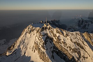
The Jungfraujoch is a saddle connecting two major 4000ers of the Bernese Alps: the Jungfrau and the Mönch. It lies at an elevation of 3,463 metres (11,362 ft) above sea level and is directly overlooked by the rocky prominence of the Sphinx. The Jungfraujoch is a glacier saddle, on the upper snows of the Aletsch Glacier, and part of the Jungfrau-Aletsch area, situated on the boundary between the cantons of Bern and Valais, halfway between Interlaken and Fiesch.

<span class="mw-page-title-main">Grimsel Pass</span> Mountain pass in Switzerland through the Bernese Alps

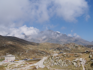
The Grimsel Pass is a mountain pass in Switzerland, crossing the Bernese Alps at an elevation of 2,164 metres (7,100 ft). The pass connects the Haslital, the upper valley of the river Aare, with the upper valley of the Rhône. In so doing, and as the Aare is a tributary of the Rhine, the pass crosses the continental divide between the North Sea and the Mediterranean Sea.

<span class="mw-page-title-main">Bernina Pass</span> Mountain pass in Graubünden, Switzerland

The Bernina Pass is a high mountain pass in the Bernina Range of the Alps, in the canton of Graubünden (Grisons) in eastern Switzerland. It connects the famous resort town of St. Moritz in the Engadin valley with the Italian-speaking Val Poschiavo, which ends in the Italian town of Tirano in Valtellina. The pass lies a few kilometres east of Piz Bernina, and south of Val Minor.

<span class="mw-page-title-main">Crans-Montana</span> Municipality in Valais, Switzerland

Crans-Montana is a municipality in the district of Sierre in the canton of Valais, Switzerland. On 1 January 2017 the former municipalities of Chermignon, Mollens, Montana and Randogne merged to form the new municipality of Crans-Montana.

<span class="mw-page-title-main">San Bernardino Pass</span> Mountain pass in the Swiss Alps

San Bernardino Pass is a high mountain pass in the Swiss Alps connecting the Hinterrhein and the Mesolcina (Misox) valleys between Thusis and Bellinzona. Located in the far eastern side of the Western Alps it is not to be confused with the Great St Bernard Pass and the Little St Bernard Pass. The top of the pass represents both the Italo-German language frontier and the watershed between the Po basin and the Rhine basin. Marscholsee is within the pass at an elevation of 2,053 m (6,736 ft).

<span class="mw-page-title-main">Säntis</span> Mountain in Switzerland

At 2,501.9 metres (8,208 ft) above sea level, Säntis is the highest mountain in the Alpstein massif of northeastern Switzerland. It is also the culminating point of the whole Appenzell Alps, between Lake Walen and Lake Constance. Shared by three cantons, the mountain is a highly visible landmark thanks to its exposed northerly position within the Alpstein massif. As a consequence, houses called Säntisblick can be found in regions as far away as the Black Forest in Germany. Säntis is among the most prominent summits in the Alps and the most prominent summit in Europe with an observation deck on the top. The panorama from the summit is spectacular. Six countries can be seen if the weather allows: Switzerland, Germany, Austria, Liechtenstein, France, and Italy.

<span class="mw-page-title-main">Lägern</span> Mountain of the Jura Mountains

The Lägern is a wooded mountain of the Jura Mountains, stretching from Baden to Dielsdorf, about 15 km north-west of Zurich. The culminating point is located 1 km west of Hochwacht within the canton of Zurich, the border with the canton of Aargau running on a slightly lower summit named Burghorn.

<span class="mw-page-title-main">Ulrichen</span> Former municipality in Valais, Switzerland

Ulrichen is a village in the municipality of Obergoms in the district of Goms in the canton of Valais in Switzerland. The population was 219.

<span class="mw-page-title-main">Napf</span> Mountain in Switzerland

The Napf is a mountain on the border between the Swiss cantons of Bern and Lucerne. With an altitude of 1,408 meters (4,619 ft), it is the summit of the Napfgebiet, the hilly region lying between Bern and Lucerne. It is counted geologically as part of the Swiss plateau, although it is sometimes considered part of the Emmental Alps. The region is bounded by the Emmental to the south-west and the Entlebuch to the east. The region is traversed by the Brünig-Napf-Reuss line.

<span class="mw-page-title-main">La Dôle</span> Mountain in Switzerland

La Dôle is a mountain of the Jura, overlooking Lake Geneva in the westernmost part of the canton of Vaud. Rising to an altitude of 1677 meters, it is the second highest peak in the Swiss portion of the Jura, after Mont Tendre. Administratively, the summit is split between the municipalities of Gingins, Chéserex and La Rippe. The mountain is also close to and easily accessible from Saint-Cergue and the Col de la Givrine to the north, both above 1000 meters and connected to Nyon on Lake Geneva by road and by the Nyon–St-Cergue–Morez Railway. A paved road also climbs to the Chalet de la Dôle below the summit from Gingins.

<span class="mw-page-title-main">Climate of Greece</span> Overview of the impacts of the climate change in Greece

The climate in Greece is predominantly Mediterranean. However, due to the country's geography, Greece has a wide range of micro-climates and local variations. The Greek mainland is extremely mountainous, making Greece one of the most mountainous countries in Europe. To the west of the Pindus mountain range, the climate is generally wetter and has some maritime features. The east of the Pindus mountain range is generally drier and windier in summer. The highest peak is Mount Olympus, 2,918 metres (9,573 ft). The northern areas of Greece have a transitional climate between the continental, the Mediterranean and the humid subtropical climate. There are mountainous areas that have an alpine climate. Also, various areas of Greece have semi-arid climates.

<span class="mw-page-title-main">Chasseral</span> Mountain in Switzerland

The Chasseral is a mountain of the Jura Mountains, overlooking Lake Biel in the Swiss canton of Bern. With an elevation of 1,606 metres above sea level, the Chasseral is the highest summit in the canton of Bern outside the Alps. It is also both the northernmost and easternmost mountain reaching over 1,500 metres in the Jura Mountains. West of the summit is located the Chasseral Ouest, where runs the border with the canton of Neuchâtel. The Chasseral Pass is located further on the west.

<span class="mw-page-title-main">MeteoSwiss</span>

MeteoSwiss, officially the Federal Office of Meteorology and Climatology, is an office of the federal administration of Switzerland. It employs 290 people at locations in Zurich, Zurich Airport, Geneva, Locarno and Payerne.

<span class="mw-page-title-main">Nätschen</span> Mountain and ski area in Switzerland

Nätschen is a mountain location and ski area above Andermatt, in the Canton of Uri, Switzerland. Higher up on Nätschen the mountain is known as Gütsch. Its highest point is 2,344 m (7,690 ft). It is one of the mountains in the Gotthard Oberalp Arena, as is Gemsstock, which is on the other side of Andermatt. It has 11 ski runs, totaling approximately 21 km of ski pistes, and 4 ski lifts, including a Detachable 4-man Chairlift. Nätschen's lifts are powered by 3 wind turbines, two of which were installed in late 2010 (E-44), the other in 2004 (E-40). These turbines are all made by Enercon. Nätschen has a railway station, run by the Matterhorn Gotthard Bahn, which is between Andermatt and Disentis/Mustér.

<span class="mw-page-title-main">Life zones of central Europe</span>

Central Europe contains several life zones, depending on location and elevation.

Munt Buffalora is a mountain of the Ortler Alps, located south of the Ofen Pass in the Swiss canton of Graubünden.

<span class="mw-page-title-main">Rheinwald, Switzerland</span> Municipality in Graubünden, Switzerland

Rheinwald is a municipality in the Viamala Region in the Swiss canton of Graubünden. On 1 January 2019 the former municipalities of Hinterrhein, Nufenen and Splügen merged to form the new municipality of Rheinwald.

References

  1. Agrawala, Shardul. (2007). Climate change in the European alps : adapting winter tourism and natural hazards management. OECD, Organisation for economic co-operation and development. ISBN   978-9264031685. OCLC   729351518.
  2. Elsasser, H; Bürki, R (2002). "Climate change as a threat to tourism in the Alps". Climate Research. 20 (3): 253–257. doi: 10.3354/cr020253 . ISSN   0936-577X.
  3. 1 2 3 4 5 6 7 8 Rubel, Franz; Brugger, Katharina; Haslinger, Klaus; Auer, Ingeborg (January 24, 2017). "The climate of the European Alps: Shift of very high resolution Köppen-Geiger climate zones 1800–2100". Meteorologische Zeitschrift. 26 (2): 115–125.
  4. "Climate normals Buchs / Aarau" (PDF). Climate diagrams and normals from Swiss measuring stations. Federal Office of Meteorology and Climatology (MeteoSwiss). Archived from the original (PDF) on 7 July 2022. Retrieved 11 September 2022.
  5. "Climate normals Scoul" (PDF). Climate diagrams and normals from Swiss measuring stations. Federal Office of Meteorology and Climatology (MeteoSwiss). Archived from the original (PDF) on 15 January 2022. Retrieved 11 September 2022. The weather station elevation is 1303 meters above sea level.
  6. "Climate normals Samedan" (PDF). Climate diagrams and normals from Swiss measuring stations. Federal Office of Meteorology and Climatology (MeteoSwiss). Retrieved 11 September 2022. The weather station elevation is 1708 meters above sea level.
  7. "Climate normals Weissfluhjoch" (PDF). Climate diagrams and normals from Swiss measuring stations. Federal Office of Meteorology and Climatology (MeteoSwiss). Retrieved 11 September 2022. The weather station elevation is 2690 meters above sea level.