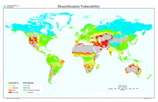
Desertification is a type of land degradation in drylands in which biological productivity is lost due to natural processes or induced by human activities whereby fertile areas become arid. It is the spread of arid areas caused by a variety of factors, such as overexploitation of soil as a result of human activity and the effects of climate change. Geographic areas most affected include the Sahel region in Africa, the Gobi Desert and Mongolia in Asia as well as parts of South America. Drylands occupy approximately 40–41% of Earth's land area and are home to more than 2 billion people.
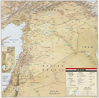
Syria is located in West Asia, north of the Arabian Peninsula, at the eastern end of the Mediterranean Sea. It is bordered by Turkey to the north, Lebanon and Israel to the west and southwest, Iraq to the east, and Jordan to the south. It consists of mountain ranges in the west and a steep area inland. In the east is the Syrian Desert and in the south is the Jabal al-Druze Range. The former is bisected by the Euphrates valley. A dam built in 1973 on the Euphrates created a reservoir named Lake Assad, the largest lake in Syria. The highest point in Syria is Mount Hermon on the Lebanese border at 2,814 metres or 9,232 feet. Between the humid Mediterranean coast and the arid desert regions lies a semiarid steep zone extending across three-quarters of the country, which receives hot, dry winds blowing across the desert. Syria is extensively depleted, with 28 percent of the land arable, 4 percent dedicated to permanent crops, 46 percent utilized as meadows and pastures, and only 3 percent forest and woodland.

A drought is a period of drier-than-normal conditions. A drought can last for days, months or years. Drought often has large impacts on the ecosystems and agriculture of affected regions, and causes harm to the local economy. Annual dry seasons in the tropics significantly increase the chances of a drought developing and subsequent wildfires. Periods of heat can significantly worsen drought conditions by hastening evaporation of water vapour, drying out forests and other vegetation and increasing fuel for wildfires.

Soil erosion is the denudation or wearing away of the upper layer of soil. It is a form of soil degradation. This natural process is caused by the dynamic activity of erosive agents, that is, water, ice (glaciers), snow, air (wind), plants, and animals. In accordance with these agents, erosion is sometimes divided into water erosion, glacial erosion, snow erosion, wind (aeolian) erosion, zoogenic erosion and anthropogenic erosion such as tillage erosion. Soil erosion may be a slow process that continues relatively unnoticed, or it may occur at an alarming rate causing a serious loss of topsoil. The loss of soil from farmland may be reflected in reduced crop production potential, lower surface water quality and damaged drainage networks. Soil erosion could also cause sinkholes.
Deserts and xeric shrublands are a biome defined by the World Wide Fund for Nature. Deserts and xeric shrublands form the largest terrestrial biome, covering 19% of Earth's land surface area. Ecoregions in this habitat type vary greatly in the amount of annual rainfall they receive, usually less than 250 millimetres (10 in) annually except in the margins. Generally evaporation exceeds rainfall in these ecoregions. Temperature variability is also diverse in these lands. Many deserts, such as the Sahara, are hot year-round, but others, such as East Asia's Gobi, become quite cold during the winter.

Dryland farming and dry farming encompass specific agricultural techniques for the non-irrigated cultivation of crops. Dryland farming is associated with drylands, areas characterized by a cool wet season followed by a warm dry season. They are also associated with arid conditions, areas prone to drought and those having scarce water resources.
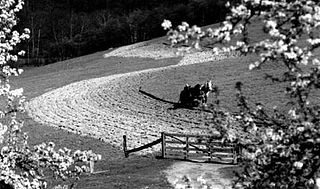
Contour bunding or contour farming or Contour ploughing is the farming practice of plowing and/or planting across a slope following its elevation contour lines. These contour lines create a water break which reduces the formation of rills and gullies during times of heavy precipitation, allowing more time for the water to settle into the soil. In contour plowing, the ruts made by the plow run perpendicular rather than parallel to the slopes, generally furrows that curve around the land and are level. This method is also known for preventing tillage erosion. Tillage erosion is the soil movement and erosion by tilling a given plot of land. A similar practice is contour bunding where stones are placed around the contours of slopes. Contour ploughing has been proved to reduce fertilizer loss, power and time consumption, and wear on machines, as well as to increase crop yields and reduces soil erosion.

Desert ecology is the study of interactions between both biotic and abiotic components of desert environments. A desert ecosystem is defined by interactions between organisms, the climate in which they live, and any other non-living influences on the habitat. Deserts are arid regions that are generally associated with warm temperatures; however, cold deserts also exist. Deserts can be found in every continent, with the largest deserts located in Antarctica, the Arctic, Northern Africa, and the Middle East.
An aridity index (AI) is a numerical indicator of the degree of dryness of the climate at a given location. The American Meteorological Society defined it in meteorology and climatology, as "the degree to which a climate lacks effective, life-promoting moisture". Aridity is different from drought because aridity is permanent whereas drought is temporary. A number of aridity indices have been proposed ; these indicators serve to identify, locate or delimit regions that suffer from a deficit of available water, a condition that can severely affect the effective use of the land for such activities as agriculture or stock-farming.
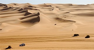
A desert is a landscape where little precipitation occurs and, consequently, living conditions create unique biomes and ecosystems. The lack of vegetation exposes the unprotected surface of the ground to denudation. About one-third of the land surface of the Earth is arid or semi-arid. This includes much of the polar regions, where little precipitation occurs, and which are sometimes called polar deserts or "cold deserts". Deserts can be classified by the amount of precipitation that falls, by the temperature that prevails, by the causes of desertification or by their geographical location.

Desert greening is the process of afforestation or revegetation of deserts for ecological restoration (biodiversity), sustainable farming and forestry, but also for reclamation of natural water systems and other ecological systems that support life. The term "desert greening" is intended to apply to both cold and hot arid and semi-arid deserts. It does not apply to ice capped or permafrost regions. It pertains to roughly 32 million square kilometres of land. Deserts span all seven continents of the Earth and make up nearly a fifth of the Earth's landmass, areas that recently have been increasing in size. As some of the deserts expand and global temperatures increase, the different methods of desert greening may provide a potential solution. Planting suitable flora in deserts has a range of environmental benefits from carbon sequestration to providing habitat for native desert fauna to generating employment opportunities to creation of habitable areas for local communities. The prevention of land desertification is one of 17 sustainable development objectives outlined by the United Nations, desert greening is a process that aims to not only combat desertification but to foster an environment where plants can create a sustainable environment for all forms of life while preserving its integrity.

Drylands are defined by a scarcity of water. Drylands are zones where precipitation is balanced by evaporation from surfaces and by transpiration by plants (evapotranspiration). The United Nations Environment Program defines drylands as tropical and temperate areas with an aridity index of less than 0.65. One can classify drylands into four sub-types:
Andrew Warren is a British physical geographer. He is Emeritus Professor of Geography at University College London, UK.

The Mu Us Desert, also known as the Maowusu Desert, is a desert in the northern Ordos Plateau in Inner Mongolia, Northwest China. Its southeastern end is crossed by the Ming Great Wall, and it forms the southern portion of the Ordos Desert. The Wuding River drains the area, and then flows into the Ordos Loop of the Yellow River.
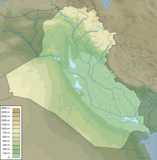
In Iraq, climate change has led to environmental impacts such as increasing temperatures, decreasing precipitation, land degradation, and water scarcity. Climate change poses numerous risks to human health, livelihoods, political stability, and the sustainable development of the nation. The combination of ecological factors, conflict, weak governance, and an impeded capacity to mitigate climate change, has made Iraq uniquely at risk to the negative effects of climate change, with the UN ranking them the 5th most vulnerable country to climate change. Rising temperatures, intensified droughts, declining precipitation, desertification, salinization, and the increasing prevalence of dust storms are challenges Iraq faces due in to the negative impacts of climate change. National and regional political instability and conflict have made it difficult to mitigate the effects of climate change, address transnational water management, and develop sustainably. Climate change has negatively impacted Iraq's population through loss of economic opportunity, food insecurity, water scarcity, and displacement.

The Chinese Loess Plateau, or simply the Loess Plateau, is a plateau in north-central China formed of loess, a clastic silt-like sediment formed by the accumulation of wind-blown dust. It is located southeast of the Gobi Desert and is surrounded by the Yellow River. It includes parts of the Chinese provinces of Gansu, Shaanxi and Shanxi. The depositional setting of the Chinese Loess Plateau was shaped by the tectonic movement in the Neogene period, after which strong southeast winds caused by the East Asian Monsoon transported sediment to the plateau during the Quaternary period. The three main morphological types in the Loess Plateau are loess platforms, ridges and hills, formed by the deposition and erosion of loess. Most of the loess comes from the Gobi Desert and other nearby deserts. The sediments were transported to the Loess Plateau during interglacial periods by southeasterly prevailing winds and winter monsoon winds. After the deposition of sediments on the plateau, they were gradually compacted to form loess under the arid climate.
Natural disasters in Nigeria are mainly related to the climate of Nigeria, which has been reported to cause loss of lives and properties. A natural disaster might be caused by flooding, landslides, and insect infestation, among others. To be classified as a disaster, there is needs to be a profound environmental effect or human loss which must lead to financial loss. This occurrence has become an issue of concern, threatening large populations living in diverse environments in recent years.
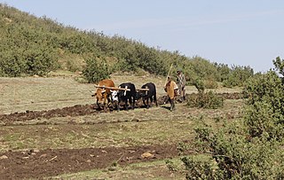
Desertification in Africa is a form of land degradation that involves the conversion of productive land into desert or arid areas. This issue is a pressing environmental concern that poses a significant threat to the livelihoods of millions of people in Africa who depend on the land for subsistence. Geographical and environmental studies have recently coined the term desertification. Desertification is the process by which a piece of land becomes a desert, as the word desert implies. The loss or destruction of the biological potential of the land is referred to as desertification. It reduces or eliminates the potential for plant and animal production on the land and is a component of the widespread ecosystem degradation. Additionally, the term desertification is specifically used to describe the deterioration of the world's drylands, or its arid, semi-arid, and sub-humid climates. These regions may be far from the so-called natural or climatic deserts, but they still experience irregular water stress due to their low and variable rainfall. They are especially susceptible to damage from excessive human land use pressure. The causes of desertification are a combination of natural and human factors, with climate change exacerbating the problem. Despite this, there is a common misconception that desertification in Africa is solely the result of natural causes like climate change and soil erosion. In reality, human activities like deforestation, overgrazing, and unsustainable agricultural practices contribute significantly to the issue. Another misconception is that, desertification is irreversible, and that degraded land will forever remain barren wastelands. However, it is possible to restore degraded land through sustainable land management practices like reforestation and soil conservation. A 10.3 million km2 area, or 34.2% of the continent's surface, is at risk of desertification. If the deserts are taken into account, the affected and potentially affected area is roughly 16.5 million km2 or 54.6% of all of Africa. 5.7 percent of the continent's surface is made up of very severe regions, 16.2 percent by severe regions, and 12.3 percent by moderate to mild regions.
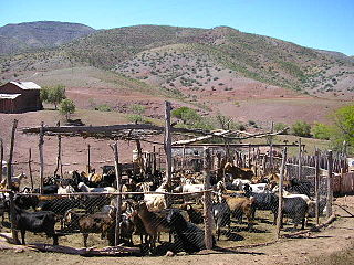
Lesotho is a country in southern Africa that is already experiencing the negative effects of climate change, including increased frequency of extreme weather, such as droughts, increased rates of soil erosion and desertification, and reduced soil fertility. Lesotho is a landlocked country that is particularly vulnerable to the negative impacts of climate variability and changes in water and food security, as well as adverse conditions to health, human settlements, and the energy sector.