
Dallas is the third-most populous city in Texas and the most populous city in the Dallas–Fort Worth metroplex, the fourth-largest metropolitan area in the United States at 7.5 million people. It is the largest city in and seat of Dallas County with portions extending into Collin, Denton, Kaufman, and Rockwall counties. With a 2020 census population of 1,304,379, it is the ninth-most populous city in the U.S. and the third-most populous city in Texas after Houston and San Antonio. Located in the North Texas region, the city of Dallas is the main core of the largest metropolitan area in the Southern United States and the largest inland metropolitan area in the U.S. that lacks any navigable link to the sea.

Fort Worth is the fifth-largest city in the U.S. state of Texas and the 13th-largest city in the United States. It is the county seat of Tarrant County, covering nearly 350 square miles (910 km2) into four other counties: Denton, Johnson, Parker, and Wise. According to a 2022 United States census estimate, Fort Worth's population was 956,709. Fort Worth is the second-largest city in the Dallas–Fort Worth–Arlington metropolitan area, which is the fourth-most populous metropolitan area in the United States, and the most populous in Texas.

The Brazos River, called the Río de los Brazos de Dios by early Spanish explorers, is the 11th-longest river in the United States at 1,280 miles (2,060 km) from its headwater source at the head of Blackwater Draw, Roosevelt County, New Mexico to its mouth at the Gulf of Mexico with a 45,000-square-mile (116,000 km2) drainage basin. Being one of Texas' largest rivers, it is sometimes used to mark the boundary between East Texas and West Texas.

The following is an alphabetical list of articles related to the U.S. state of Texas.

The Trinity River is a 710-mile (1,140 km) river, the longest with a watershed entirely within the U.S. state of Texas. It rises in extreme northern Texas, a few miles south of the Red River. The headwaters are separated by the high bluffs on the southern side of the Red River.
This article traces the history of Dallas, Texas,.
Lewisville Lake, formerly known as Garza-Little Elm Reservoir, is a reservoir in North Texas (USA) on the Elm Fork of the Trinity River in Denton County near Lewisville. Originally engineered in 1927 as Lake Dallas, the reservoir was expanded in the 1940s and 1950s and renamed Lewisville Lake. It was built for flood control purposes and to serve as a water source for Dallas and its suburbs, but residents also use it for recreational purposes.

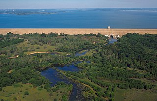
Lake Whitney is a flood control reservoir on the main stem of the Brazos River in Texas. It is located on River Mile Marker 442 and controls drainage for 17,656 square miles (45,730 km2) of Texas and parts of New Mexico. The reservoir encompasses a surface area of more than 23,500 acres and 225 miles (362 km) of shoreline. The area consists of rolling, tallgrass prairies; cedar trees; hardwood timber; and 100 ft (30 m) bluffs and rock points. Lake Whitney is also part of the Texas Lakes Trail Region of North Texas.
Herbert Eugene Bolton was an American historian who pioneered the study of the Spanish-American borderlands and was a prominent authority on Spanish American history. He originated what became known as the Bolton Theory of the history of the Americas which holds that it is impossible to study the history of the United States in isolation from the histories of other American nations, and wrote or co-authored ninety-four works. A student of Frederick Jackson Turner, Bolton disagreed with his mentor's Frontier theory and argued that the history of the Americas is best understood by taking a holistic view and trying to understand the ways that the different colonial and precolonial contexts have interacted to produce the modern United States. The height of his career was spent at the University of California, Berkeley where he served as chair of the history department for twenty-two years and is widely credited with making the renowned Bancroft Library the preeminent research center it is today.
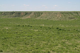
The term Cross Timbers, also known as Ecoregion 29, Central Oklahoma/Texas Plains, is used to describe a strip of land in the United States that runs from southeastern Kansas across Central Oklahoma to Central Texas. Made up of a mix of prairie, savanna, and woodland, it forms part of the boundary between the more heavily forested eastern country and the almost treeless Great Plains, and also marks the western habitat limit of many mammals and insects.

The Dallas–Fort Worth Metroplex sits above Cretaceous-age strata ranging from ≈145-66 Ma. These Cretaceous-aged sediments lie above the eroded Ouachita Mountains and the Fort Worth Basin, which was formed by the Ouachita Orogeny. Going from west to east in the DFW Metroplex and down towards the Gulf of Mexico, the strata get progressively younger. The Cretaceous sediments dip very gently to the east.

The geography of Texas is diverse and large. Occupying about 7% of the total water and land area of the U.S., it is the second largest state after Alaska, and is the southernmost part of the Great Plains, which end in the south against the folded Sierra Madre Oriental of Mexico. Texas is in the South Central United States of America, and is considered to form part of the U.S. South and also part of the U.S. Southwest.
Quiscat was a prominent 18th century Native American tribal chief, whose ethnic community, the Tawakoni, inhabited an area in what is now East Central Texas.
Preston Trail, later known as the Old Preston Road, was a road created by the Republic of Texas in 1841 from Preston, Texas on the Red River south to Austin, Texas. This road closely followed an existing trail that led across the area that had been used for centuries. This road was a main transportation artery from Central Texas to North Texas in the latter half of the 19th century. Today, Texas State Highway 289 follows near this former road.
The White River is an intermittent stream in the South Plains of Texas and a tributary of the Brazos River of the United States. It rises 8 miles (13 km) west of Floydada in southwestern Floyd County at the confluence of Callahan and Runningwater Draws. From there, it runs southeast for 62 miles (100 km) to its mouth on the Salt Fork of the Brazos River in northwestern Kent County. Besides these two headwaters, which rise near Hale Center and in Curry County, New Mexico, respectively, other tributaries include Pete, Crawfish, and Davidson Creeks. The White River drains an area of 1,690 sq mi (4,377 km2).
The Neche were a Native American tribe from eastern Texas.

Caddo Mounds State Historic Site (41CE19) is an archaeological site in Weeping Mary, Texas. This Caddoan Mississippian culture site is composed of a village and ceremonial center that features two earthwork platform mounds and one burial mound. Located on an ancient Native American trail later named by the Spanish as El Camino Real de los Tejas, the settlement developed hundreds of years before the arrival of Europeans to the region. Archaeologists believe the site was created in approximately 800 CE, with most major construction taking place between 1100 and 1300 CE.
The Battle of Village Creek occurred on May 24, 1841, on the embankments of Village Creek. The battle, which evolved into a running gunfight between the Republic of Texas militia and the Village Creek tribes, was attributed to the increased Native American raids on Anglo settlements in the Red River counties.
Diego Ortiz Parrilla was an 18th-century Spanish military officer, governor, explorer, and cartographer.

