The history of Swansea covers a period of continuous occupation stretching back a thousand years, while there is archaeological evidence of prehistoric human occupation of the surrounding area for thousands of years before that.[1]
Swansea (Welsh: Abertawe) occupies a position at the mouth of the River Tawe adjacent to an extensive bay at the western end of the Bristol Channel. It was founded as a town in the early 12th century, centred around its Norman castle. Part of the Lordship of Gower, established after the Norman invasion of Wales, it suffered episodes of destructive attack by forces of the displaced Welsh princes before developing into a prosperous market town and as a port with trading links across the Bristol Channel, as well as to France and Ireland. By the 18th century it was well established as a civic and cultural entity and as a fashionable tourist resort.[2]
With the expansion of the coal mining and copper smelting industries in the Swansea Valley in the 18th and early 19th century, Swansea became the centre of a new industrial and commercial area. The combination of a distinctively diverse, cosmopolitan, rapidly expanding population, a flourishing provincial science movement and a strong commercial and industrial base secured its pre-eminent and unique status in the urban history of early 19th century Wales.[3]
Industry grew throughout the 19th century, changing the geography of the town as its surrounding areas became incorporated into its municipal boundaries. In 1889 Swansea attained county borough status. Throughout the 20th century industry declined but the town continued to grow in population. Swansea officially gained city status in 1969.[4]
Early history
The oldest known remains on the Gower Peninsula are the Red Lady of Paviland: human bones dating from 22,000 BC.[5] Later inhabitants also left their mark on the land. Examples include the Bronze Age burial mound at Cillibion and the Iron Agehill fort, Cil Ifor.[6] Isolated prehistoric artifacts have been found in the area the city proper occupies, but there are far more on Gower. The remains of a Roman villa were also excavated on Gower.
The Welsh name, Abertawe, translates to mouth of the Tawe.[7] It first appears c.1150 as Aper Tyui.[8]
By the late 10th century, the region, including the land around the bay and the Gower, was part of the Welsh kingdom of Deheubarth under Maredudd ap Owain. The Vikings arrived sometime between the 9th and 11th centuries, leaving behind their name for a settlement in the area. The precise nature and location of this settlement are still disputed. Spellings such as Swensi, Sweni and Svenshi are found on coins minted around 1140,[9]
In the wake of the Norman Conquest and Norman invasion of Wales, Gower became a marcher lordship which included not only the peninsula itself but also the land to the east as far north as the River Amman and east to the River Tawe. This included the site of Swansea town, which was designated the capital of the area. Although Kilvey Hill is to the east of the Tawe, the manor of Kilvey was also associated with Gower. The new Norman lords encouraged English immigration into the area. This immigration was largely from the West Country.
A turf and timber motte and baileycastle was erected in Swansea in 1106 and was assailed by the local Welsh ten years later (and several more times in the following century). The original castle was subsequently rebuilt in stone. The Braose family—memorialised in local placenames and road names today as de Breos—possessed Gower in the 13th century and lived at Oystermouth Castle.
The port and industrialisation
The South Wales Coalfield reaches the coast in this region, and coal was being exported by the year 1550, along with great quantities of limestone, quarried in the Mumbles area and on Gower and in high demand as fertiliser. Swansea was already a significant port with trading links across the Bristol and English Channels and the Irish Sea. There was a constant influx of migrants from the Welsh countryside, which occasioned the protest of 1603.[10]
The population at this time was concentrated around the castle and river. Despite small-scale coal mining, the bulk of the area beyond the town was still largely farmland. Swansea Bay was considered an attractive region. In the 18th century, some local notables wanted to direct future development into promoting it as a resort. Their plans were frustrated by the rapid development of industry in the area.
By weight, more coal than copper ore is needed for the process of smelting copper from the ore, so it is more economical to build the smelter near the coal source. Swansea had very local mines, a navigable river, a nearby supply of limestone (necessary as flux), and trading links across the Bristol Channel to Cornwall and Devon, sources of copper ore.
As the Industrial Revolution took off, a series of works were built along the Tawe river from 1720 onwards and a series of mines were opened. Initially, the smelting works concentrated on copper. Coal was brought down to them by waggonways and tramways; copper ore was brought on ships which could sail right up to the works; the resulting copper was exported out again. Swansea had become "Copperopolis", processing at its peak as much as 70% of the world's copper, and the lower Tawe valley became a mass of industry.
More and more riverside wharfs were built. Tramways, waggonways and railways proliferated and connected the different works and the collieries supplying them. Today's Hafod was originally the village of Vivianstown (Vivian & Sons owned the Hafod Copper Works); and Morriston was founded c. 1790 (the exact date is unclear) by the Morris family who owned the Cambrian Works among other properties. By 1750, the Swansea district was providing half the copper needs of Britain.[11]
The Cambrian Works closed down as a smelter but reopened as the Cambrian Pottery in 1764: pottery-making is another industry which requires vast quantities of coal (available locally) and clay and flint (available from the West Country, readily accessible by water). The Glamorgan Pottery was founded in 1813 by the ex-manager of the Cambrian Pottery, right next door to it and in direct competition with it. Not only the managers of the potteries but many of the workers came originally from Staffordshire.[12] From 1814 to about 1822 the Cambrian made fine porcelain with excellent overglaze enamel painting, mostly of flowers. Examples of Swansea pottery can be seen today at the Glynn Vivian Art Gallery and at Swansea Museum
One of the most well-known pieces of Swansea's history began life at this stage: the Mumbles Railway. This started in the first decade of the 19th century as an industrial tramway: a horse pulling a cart along tram plates. It had a specific branch line into Clyne valley where Sir John Morris, one of the railway's owners, owned coal mines. Despite some early journeys made by tourists, it was not until the 1860s that the railway began to carry passengers regularly, by which time it had acquired rails instead of tram plates.
As the town expanded, gates put up by the local turnpike trust were no longer on the outskirts of town but in the town itself. Originally travel between Swansea and other towns or villages had involved paying tolls. Now, travel around the town itself required toll money. This was naturally an unpopular development, and in 1843, Swansea inhabitants made their own contribution to the Rebecca Riots, burning the Ty Coch gate in St Thomas. In the same year, workers from all the copper works in Swansea went on strike after their wages were cut. They returned to work five weeks later, having failed to restore their wages. The strike must have been born of desperation. It was known that John Henry Vivian, one of the owners of the copperworks, was no supporter of workers' rights: he had blacklisted men involved in earlier disturbances.
Civil disturbances were a regular feature of the 1840s in Swansea. This was the period of the Rebecca Riots, of Chartism in the valleys to the east with the Merthyr Rising and the Newport Rising, and general discontent. Huge crowds would gather when those suspected of involvement in Rebecca activities were brought to the station house, and the riot was provoked when one suspect was arrested on the Sabbath (Molloy). At this time, Colonel James Frederick Love commanded militia who were billeted in Swansea, and (in 1843):
Colonel Love had serious problems in deciding how best to stretch his resources. And stretched they were, because it was equally clear that Swansea needed to be strongly garrisoned to cope with violent incursions by unemployed coal and iron workers and discontented country-people, as would Llanelli when the Gwendraeth Valley troubles reached their climax in the following two months. And all the time the Chartist threat hung over the industrial areas to the east.[13]
In this early part of the 19th century, the area which is now Brynmill, Sketty, the Uplands and the university campus was where several of the owners of the "manufactories" lived, in large park-like estates well to the west of the Tawe. The workers were crammed along the banks of the Tawe and lived in poor conditions. The prevailing wind carried the smoke from the copper works to the east, towards St Thomas and Kilvey. A contemporary report written by a doctor describing Swansea Valley speaks of a nightmare landscape, "literally burnt" where few plants would grow, dotted with lifeless pools, slag heaps, mounds of scoriae and smoke from the works everywhere.[14]George Borrow, later to write and publish his Wild Wales, visited the town in the same year, describing it slightly less emphatically as "a large, bustling, dirty, gloomy place".
Writing in 1860, John Murray reports:
To the traveller who crosses the Llandore bridge at night, the livid glare from the numerous chimneys, the rolling, fleecy, white clouds that fill up the valley beneath him, the desolate-looking heaps of slag on either side, might well recalls Dante's line - "voi che entrate lasciate ogni speranza" and records there are no trees, and instead of grass a yellow sickly growth of chamomile scarcely covers the ground.[15]
The contrast between the living conditions of workers and their employers the mine-owners and ironmasters was stark, although entertainment interests sometimes overlapped: both workers and employers flocked to the Swansea horse races, for example, held at Crymlyn Burrows. In addition to the racing, this was also the scene of boxing, gambling, cock-fighting, shows and drinking.[16]
The importance of Swansea as a centre of a new industrial and commercial area at the forefront of the industrial revolution was recognised by the Bank of England which established its first Welsh branch in he town in 1826. Swansea also became prominent as a focus for scientific, literary and cultural life in South Wales. In 1835 a Scientific Society was formed and subsequently re-established as the Royal Institution of South Wales based in the first purpose-built museum in Wales which opened in 1841. With its reputation as "the intelligent town" thus enhanced, Swansea hosted the annual meetings of the British Association for the Advancement of Science in 1848 and 1880. Swansea was the home to the first weekly newspapers to be published in Wales: the English-language The Cambrian from 1804, and the Welsh-language Seren Gomer from 1814.[17]
Swansea's population rose from under 2000 in 1750 to over 6000 in 1800, to 10,255 by 1821 and to over 18,000 by 1835 with in-immigration the predominant factor.[18] With the expansion of its municipal boundaries, by 1888 its population had reached over 78,000 and by 1918, 160,810.[19] Due to immigration by 1881 more than a third of the borough's population had been born outside Glamorgan, and just under a quarter outside Wales.[20]
Victorian slums and reform
In order to allow boats to dock without running aground at low tide and to remain afloat, the "Float" was constructed: the Tawe was diverted and a new dock with locks created. Work began in 1852, and the result was New Dock in 1859. Further changes to the docks were proposed, and the town authorities realised the potential grave effect on public health, particular in the riverside St Thomas area.[21] Drinking water came from springs locally but clean water sources were increasingly rare. Cholera broke out in 1832; and again in 1849.[21]
There was no sewerage system in Swansea until 1857[21] and the water supply in areas above the reservoir level was "in many cases of a questionable character" (contemporary report quoted by Dean[21]). The Lliw reservoir of 1863 helped provide clean water, but drainage of dirty water was still a problem.[21]
In 1865, Swansea suffered an epidemic of yellow fever, the only outbreak of that disease on the British mainland. A cargo of copper ore from Cuba was landed in exceptionally hot weather in September, and with it a number of infected mosquitoes. In a month, 27 inhabitants were infected and 15 died.
Swansea saw yet another outbreak of cholera in 1866 and the local authorities were eventually forced by legislation to act. The only way to improve some areas was wholesale slum clearance, and this was the solution imposed in several regions of Swansea, notably Greenhill (current Dyfatty and Alexandra Road area), an area with massive overcrowding and consequent disproportionate incidence of cholera cases. It was populated largely by Irish immigrants, many of whom had fled the potato famines. Several of the landlords of Greenhill making great profits from their rents, and who required recompense for the loss of their properties, were local dignitaries, including Lewis Llewelyn Dillwyn, MP. (Dean)
Sewage and pollution were also part of the cause of the decline of the oyster trade centred on Mumbles, also known as Oystermouth. Kilvert's diary described a thriving and ancient industry in 1872; within five years, it had almost completely collapsed.
Industrial decline
The construction of the Taff Vale Railway and the Bute West Dock in the 1840s resulted in Cardiff surpassing Swansea as the principal coal port in South Wales, and by 1871 Cardiff's population exceeded that of Swansea. In the late 19th century, Swansea copper smelters faced increased foreign competition, and some of the leading smelters in the region diversified into other non-ferrous metals. In the ferrous sector, rapid growth in demand for tinplate - particularly in the USA - facilitated a local boom; the imposition of the McKinley Tariff in 1891 caused a significant fall in production, but tinplate continued to be a significant local economic activity into the first half of the 20th century,[22] with demand buoyant during the two world wars.
During the Second World War, Swansea's Queen's Dock was one end of the world's first test of a full-scale submarine oil pipeline, in Operation Pluto. Swansea was a target for Nazi Germanbombing raids due to its industries, the port, and railways. By the end of the so-called Three Nights' Blitz, three consecutive nights of particularly intensive bombing in February 1941, the town centre was flattened, along with many residential streets. Rebuilding post-war was in typical British nineteen-fifties style and much of the result is regarded with high favour by neither residents nor visitors. One consequence of the bombing and rebuilding is the movement of the town centre by about half a mile. Pre-war, the town centre was on an axis around High Street and Wind Street. Post-war, Oxford Street and the new road the Kingsway took more prominence.[23]
The Mumbles Railway was closed in 1960. By 1960, industry in the valley was in steep decline and the landscape was littered with abandoned metalworks and the waste from them. The Lower Swansea Valley Scheme was started: an attempt to reclaim the polluted land into something usable. The Enterprise Zone at Llansamlet is built on part of this land. Further down the river, the Tawe was diverted—again—and the Parc Tawe development sits on top of the old North Dock. The old South Dock area now holds the Leisure Centre and Marina.
Swansea is a coastal city and the second-largest city of Wales. It forms a principal area, officially known as the City and County of Swansea.
Until 1974, Glamorgan, or sometimes Glamorganshire, was an administrative county in the south of Wales, and later classed as one of the thirteen historic counties of Wales. Originally an early medieval petty kingdom of varying boundaries known in Welsh as Morgannwg, which was then invaded and taken over by the Normans as the Lordship of Glamorgan. The area that became known as Glamorgan was both a rural, pastoral area, and a conflict point between the Norman lords and the Welsh princes. It was defined by a large concentration of castles.
Burry Port is a port town and community in Carmarthenshire, Wales, on the Loughor estuary, to the west of Llanelli and south-east of Kidwelly. Its population was recorded at 5,680 in the 2001 census and 6,156 in the 2011 census, and estimated at 5,998 in 2019. The town has a harbour. It is also where Amelia Earhart landed as the first woman to fly across the Atlantic Ocean. Nearby are the Pembrey Burrows sand dune and wetland system, forming a country park, and the Cefn Sidan sands. Its musical heritage includes Burry Port Opera, Male Choir and Burry Port Town Band.
Swansea Bay is a bay on the southern coast of Wales. The River Neath, River Tawe, River Afan, River Kenfig and Clyne River flow into the bay. Swansea Bay and the upper reaches of the Bristol Channel experience a large tidal range. The shipping ports in Swansea Bay are Swansea Docks, Port Talbot Docks and Briton Ferry wharfs.
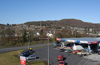
Pontardawe is a town and a community in the lower Swansea Valley. it had a population of approximately 7,172 in the 2021 Census for Pontardawe Parish, and forms part of the county borough of Neath Port Talbot.
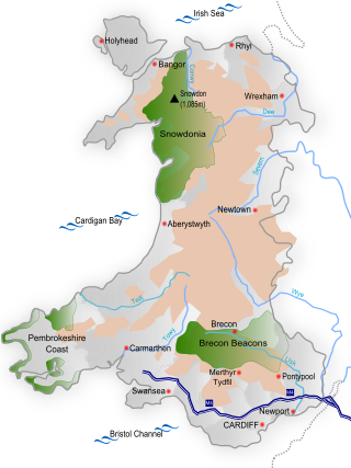
South Wales is a loosely defined region of Wales bordered by England to the east and mid Wales to the north. Generally considered to include the historic counties of Glamorgan and Monmouthshire, south Wales extends westwards to include Carmarthenshire and Pembrokeshire. In the western extent, from Swansea westwards, local people would probably recognise that they lived in both south Wales and west Wales. The Brecon Beacons National Park covers about a third of south Wales, containing Pen y Fan, the highest British mountain south of Cadair Idris in Snowdonia.
The Swansea and Mumbles Railway was the venue for the world's first passenger horsecar railway service, located in Swansea, Wales, United Kingdom.
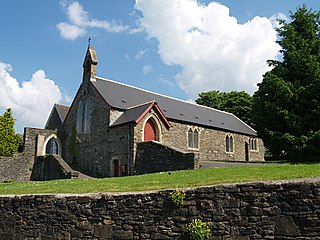
Oystermouth is a village in the district of Mumbles, Swansea, Wales. It is part of the Mumbles community.
Wales is a country that is part of the United Kingdom and whose physical geography is characterised by a varied coastline and a largely upland interior. It is bordered by England to its east, the Irish Sea to its north and west, and the Bristol Channel to its south. It has a total area of 2,064,100 hectares and is about 170 mi (274 km) from north to south and at least 60 mi (97 km) wide. It comprises 8.35 percent of the land of the United Kingdom. It has a number of offshore islands, by far the largest of which is Anglesey. The mainland coastline, including Anglesey, is about 1,680 mi (2,704 km) in length. As of 2014, Wales had a population of about 3,092,000; Cardiff is the capital and largest city and is situated in the urbanised area of South East Wales.
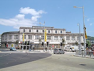
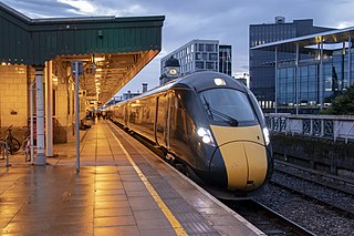
Swansea railway station serves the city of Swansea, Wales. It is 216 miles 7 chains (348 km) measured from London Paddington on the National Rail network.
Birchgrove is a suburb and community in Swansea, Wales, United Kingdom. It is situated about 4.5 miles (7 km) north-east of Swansea city centre, between the flood plain of the River Tawe and Mynydd Drumau. The community of Birchgrove had a population of 7,392 in 2011.
Morriston is a community in the City and County of Swansea, Wales and falls within the Morriston ward. It is the largest community in Swansea county.
Transport in Wales is heavily influenced by the country's geography. Wales is predominantly hilly or mountainous, and the main settlements lie on the coasts of north and south Wales, while mid Wales and west Wales are lightly populated. The main transport corridors are east–west routes, many continuing eastwards into England.
The Swansea Canal was a canal constructed by the Swansea Canal Navigation Company between 1794 and 1798, running for 16.5 miles (26.6 km) from Swansea to Hen Neuadd, Abercraf in South Wales. It was steeply graded, and 36 locks were needed to enable it to rise 373 feet (114 m) over its length. The main cargos were coal, iron and steel, and the enterprise was profitable.
The South Wales Coalfield extends across Pembrokeshire, Carmarthenshire, Swansea, Neath Port Talbot, Bridgend, Rhondda Cynon Taf, Merthyr Tydfil, Caerphilly, Blaenau Gwent and Torfaen. It is rich in coal deposits, especially in the South Wales Valleys.
Swansea Docks is the collective name for several docks in Swansea, Wales. The Swansea docks are located immediately south-east of Swansea city centre. In the mid-19th century, the port was exporting 60% of the world's copper from factories situated in the Tawe Valley. The working docks area today is owned and operated by Associated British Ports as the Port of Swansea and the northern part around the Prince of Wales Dock is undergoing re-development into a new urban area branded the SA1 Swansea Waterfront.
The Lower Swansea valley is the lower half of the valley of the River Tawe in south Wales. It runs from approximately the level of Clydach down to Swansea docks, where it opens into Swansea Bay and the Bristol Channel. This relatively small area was a focus of industrial innovation and invention during the Industrial Revolution, leading to a transformation of the landscape and a rapid rise in the population and economy of Swansea.
The City and County of Swansea is an urban centre with a largely rural hinterland in Gower; the city has been described as the regional centre for South West Wales. Swansea's travel to work area, not coterminous with the local authority, also contained the Swansea Valley in 1991; the new 2001-based version merges the Swansea, Neath & Port Talbot, and Llanelli areas into a new Swansea Bay travel to work area. Formerly an industrial centre, most employment in the city is now in the service sector.
The Industrial Revolution in Wales was the adoption and developments of new technologies in Wales in the 18th and 19th centuries as part of the Industrial Revolution, resulting in increases in the scale of industry in Wales.
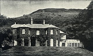
Maesteg House was a manor house built on the south slope of Kilvey Hill, Swansea. It was built in the mid 19th century by the copper and tin industrialist Pascoe St Leger Grenfell. The building is no longer there, as it was demolished shortly after the First World War to make way for new housing development.
References
↑ Gabb, Gerald (2007). Swansea and its History. Volume I. Swansea: Gerald Gabb. pp.128–140. ISBN0-9527151-2-0.
↑ Gabb, Gerald (2019). Swansea and its History. Volume II: The Riverside Town. Part 1: The Men of Power. Swansea: Gerald Gabb. pp.5–26. ISBN978-0-9527151-4-6.
↑ Miskell, Louise (2006). ‘Intelligent Town’: An Urban History of Swansea, 1780-1855. Cardiff: University of Wales Press. pp.13, 192.
↑ See Place-Names in Glamorgan, Gwynedd O. Pierce, p 182.
↑ "A hoard of coins found at Rhiwbina in the north of Cardiff in 1980 contained ... minted at Swansea c. 1140 and bore abbreviated forms of the name: SWENSI, SWENS, SVEN, SWENI, SVENSHI." Quoted from Place-names in Glamorgan, Gwynedd O. Pierce, 2002. ISBN1-898937-57-5; pg. 182
↑ Davies, John (1990). A History of Wales. London: Penguin Books. p.267.
↑ Davies, John (1990). A History of Wales. London: Penguin Books. p.316.
↑ A Guide to the Potteries and Decorators Swansea Museum Services
↑ And They Blessed Rebecca: an account of the Welsh toll-gate riots 1839-1844, Pat Molloy, 1983. ISBN0-86383-031-5.
↑ The Effects of the Copper-Smoke, Thomas Williams, 1854.
↑ A handbook for travellers in South Wales, John Murray, 1860.
↑ Campbell, Robin. (2004). All Bets Are Off: Horse Racng in Swansea. Llandysul: Gomer Press.
↑ Miskell, Louise (2006). ‘Intelligent Town’: An Urban History of Swansea, 1780-1855. Cardiff: University of Wales Press. pp.13, 52–53, 158–181. ISBN978-0-7083-2510-0.
↑ Miskell, Louise (2006). ‘Intelligent Town’: An Urban History of Swansea, 1780-1855. Cardiff: University of Wales Press. pp.31, 42, 140. ISBN978-0-7083-2510-0.
↑ Harris, E. (1934) Swansea: Its Port and Trade and their Development. Cardiff: Western Mail and Echo Ltd, pp. 175-76
↑ Rosser, C. and Harris, C.C. (1998) The Family and Social Change: A Study of Family and Kinship in a South Wales Town. London: Routledge
1 2 3 4 5 Slums: living conditions in the 19th century Swansea by Bob Dean: published by Swansea Museum Services.
↑ Miskell, L (2004) Swansea Bay 1904, Old Ordnance Survey Maps. England & Wales Sheet 247
Davies, John (1990). A History of Wales. London: Penguin Books.
Gabb, Gerald (2007). Swansea and its History. Volume I. Swansea: Gerald Gabb. ISBN0-9527151-2-0.
Gabb, Gerald (2019). Swansea and its History. Volume II: The Riverside Town. Part 1: The Men of Power. Swansea: Gerald Gabb. ISBN978-0-9527151-4-6.
Gabb, Gerald (2019). Swansea and its History. Volume II: The Riverside Town. Part 2: The Town, The Port, The People. Swansea: Gerald Gabb. ISBN978-0-9527151-5-3.
Gabb, Gerald (2019). Swansea and its History. Volume II: The Riverside Town. Part 3: Castle, Churches, Inns, Markets, Sources. Swansea: Gerald Gabb. ISBN978-0-9527151-6-0.
Hughes, Stephen (2005) Copperopolis: Landscapes of the Early Industrial Period in Swansea, Aberystwyth: Royal Commission on the Ancient and Historical Monuments of Wales. ISBN1-871184-27-4
Miskell, Louise (2004) Swansea Bay 1904, Old Ordnance Survey Maps. England & Wales Sheet 247
Miskell, Louise (2006). ‘Intelligent Town’: An Urban History of Swansea, 1780-1855. Cardiff: University of Wales Press. ISBN978-0-7083-2510-0.
Lower Swansea Valley Factsheets, numbers 1 to 8 Swansea Museum Services
External links
Swansea heritage net: major project to digitise important pieces in Swansea Museum Service's collection.
Cable Tramway: Details of the Swansea Constitution Hill cable tramway.
This page is based on this Wikipedia article Text is available under the CC BY-SA 4.0 license; additional terms may apply. Images, videos and audio are available under their respective licenses.