Thomas Bouch
| | This section is empty.You can help by adding to it.(March 2014) |
The Firth of Forth was historically crossed by ferry until the opening of the Forth Road Bridge in 1964.
It is possible that a boat bridge made of around 500 boats across the Forth could have been constructed by Septimius Severus and his son Caracalla during their campaign in Scotland c. 208. [1] Divided in the middle by Inchgarvie, a 1.25 miles (2.01 km) bridge made of boats secured to long mooring ropes was within the capabilities of the Romans at the time, and with several tens of thousands of men campaigning north of the river such an investment may have been worthwhile. [1] Whilst there is no evidence of such a bridge being built at Queensferry, the Romans are known to have built such bridges elsewhere. [1] [2]
A regular service is known to have crossed at Queensferry as early as the 12th century, using a series of natural rock landings west of Queensferry Harbour. [3] Small permanent structures existed at both sides of the crossing by 1710, but by 1760 these were considered inadequate for the most trafficked ferry passage in Scotland. [3] A 1772 petition to the Forfeited Estates Commission from an unknown engineer requested GB£980 for improvements, who in turn consulted civil engineer John Smeaton. [3] Smeaton considered the largely natural landings to be the greatest issue, especially at low water, and recommended an increased number of landings in order to prevent boats having to tack, as well as specific improvements to existing piers. [4] By July 1777, the Royal Burghs of Scotland had given GB£300 and the Forfeited Estates Commission GB£600, the latter on the basis of its importance as a military route. [4] The Board of Trustees for Fisheries, Manufactures and Improvements in Scotland also contributed to the repair of two piers. [5]
John Rennie the Elder made improvements worth GB£34,000 to a number of piers by 1812, and further works were carried out when expenditure of GB£20,000 was authorised in 1814. [6] The harbour at South Queensferry was brought to its present form by an 1817 plan from Hugh Baird, who turned the west pier at a right angle to further enclose the harbour. [5] [7]
Robert Stephenson was called by the ferry superintendent in 1817 to advise on how to furnish the passage with lighting. [8]
In September 1819, a steamboat started operation at the "Broad Ferry" between Newhaven and Dysart, resulting in the Queensferry Passage losing two-thirds of its traffic by the autumn of 1820. [8] The design of the piers and the fast-flowing tides made the Queensferry crossing unsuitable for steamboats, but a paddle steamboat named the Queen Margaret was entered service in 1821 to tow sailing boats. [8] Only the southern landing at Longcraig Pier could accommodate it, and because of the protruding paddles it could not load wheeled cargo. [8] In that same year a fleet of sailing boats was introduced, but despite the efficiency of the operation, it could not compete with the Broad Ferry and in 1828 the Trustees consulted with engineer Thomas Telford with a view to making improvements. [8]
George Bruce of Carnock tunnelled far out under the Forth in the 1600s, with John Taylor describing the pit in 1618. [9] Taylor describes how after building a circular stone cofferdam, the workmen dug down 40 feet (12 m) into the coal seam, and followed it out to sea. In "eight and twenty or nine and twenty yeeres", they dug over an English mile out to sea. The tunnel was cut like an arch, and tall enough for a man to walk upright in most places, with three horses powering 36 buckets to keep the mine drained. [10] The tunnel lasted until 1625, when the sea washed over the cofferdam in a storm. [11] While this tunnel was never intended to be a means of transport, they are testimony to Bruce's "great knowledge and skill in machinery." [11]
A 2.5-mile (4.0 km) tunnel linking Valleyfield colliery in Fife to Kinneil colliery near Bo'ness was completed in 1964 so that coal could be transported 500 metres (1,600 ft) under the Forth to the more modern coal processing facilities at Kinneil. The collieries were closed in 1978 and 1983 and the tunnel was sealed off. [12] [13]
A proposal to tunnel under the Forth from Inchgarvie was put forward in around 1790, but the difficulty of tunnelling through whinstone meant it was not taken seriously. [14] The success of coal mining operations to the west of Queensferry meant that a proposal mooted in 1805 for a tunnel 1.5 miles (2.4 km) of Inchgarvie was taken much more seriously. [15]
Twin 15 feet (4.6 m) wide arches would be bored at a maximum depth of 30 fathoms (180 ft; 55 m) through what was thought to be freestone, with construction anticipated to cost GB£160,000 - 170,000 over a four-year period. [15] A revised scheme in 1806 moved the tunnel westward, away from Hopetoun House, after objections from the Earl of Hopetoun. [15] This scheme also received support, and Robert Bald suggested making soundings and borings as an initial step towards construction, but tunnelling never started, likely for economic reasons. [16] This proved to be serendipitous, as the freestone was proved to run at a depth of 1,800 feet (550 m) under the Forth when the Kinneil and Valleyfield mines were joined in 1964. [17] [18] Other tunnels through similar material attempted at the time failed, notably an attempt to tunnel under the River Thames between Gravesend and Tilbury. [17]
In 2021, the Scottish Greens proposed a 9 miles (14 km) long rail tunnel from Kirkcaldy to Leith which would bypass the Forth Bridge. If built, it is suggested that it would cut journey times from Edinburgh to the north by 25 minutes, while adding capacity to the railway network. [19]
Bridges were possibly proposed as early as 1740 or 1758, but no records have been found. [1] The materials available at the time, namely stone and wood, offered a limited maximum span of around 30 metres, making construction of such bridges in deep water unfeasible. [1] After Henry Cort invented puddling in 1783 as a method of producing large quantities of high-quality iron, such bridges could again be considered. [1] Scotland had four wrought-iron footbridges by 1817, with the longest spanning a distance of 261 feet (80 m). [1]
| | This section is empty.You can help by adding to it.(March 2014) |
In 2007, in a two-week trial jointly funded by SEStran and Stagecoach, a passenger hovercraft ran between Kirkcaldy and Edinburgh, [20] but Stagecoach have indicated that they are not interested in developing this into a service. [21]
The new Stirling-Alloa-Kincardine rail link diverted coal trains away from the bridge. Instead they travel via Stirling to Longannet Power Station. Freight restrictions may then be lifted, with the potential of increasing the number of trains from 10 tph (trains per hour) to 12.
Firth is a word in the English and Scots languages used to denote various coastal waters in the United Kingdom, predominantly within Scotland. In the Northern Isles, it more usually refers to a smaller inlet. It is linguistically cognate to fjord which has a more constrained sense in English. Bodies of water named "firths" tend to be more common on the Scottish east coast, or in the southwest of the country, although the Firth of Lorn is an exception to this. The Highland coast contains numerous estuaries, straits, and inlets of a similar kind, but not called "firth" ; instead, these are often called sea lochs. Before about 1850, the spelling "Frith" was more common.

The Firth of Forth is the estuary (firth) of several Scottish rivers including the River Forth. It meets the North Sea with Fife on the north coast and Lothian on the south.

The Forth Road Bridge is a suspension bridge in east central Scotland. The bridge opened in 1964 and at the time was the longest suspension bridge in the world outside the United States. The bridge spans the Firth of Forth, connecting Edinburgh, at South Queensferry, to Fife, at North Queensferry. It replaced a centuries-old ferry service to carry vehicular traffic, cyclists and pedestrians across the Forth; railway crossings are made by the nearby Forth Bridge, opened in 1890.

North Queensferry is a village in Fife, Scotland, situated on the Firth of Forth where the Forth Bridge the Forth Road Bridge, and the Queensferry Crossing all meet the Fife coast, some 10 miles (16.1 km) from the centre of Edinburgh. According to the 2011 census, the village has a population of 1,076. It is the southernmost settlement in Fife.

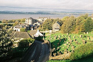
Queensferry, also called South Queensferry or simply "The Ferry", is a town to the west of Edinburgh, Scotland. Traditionally a royal burgh of West Lothian, it is administered by the City of Edinburgh council area. It lies ten miles to the north-west of Edinburgh city centre, on the shore of the Firth of Forth between the Forth Bridge, Forth Road Bridge and the Queensferry Crossing. The prefix South serves to distinguish it from North Queensferry, on the opposite shore of the Forth. Both towns derive their name from the ferry service established by Queen Margaret in the 11th century, which continued to operate at the town until 1964, when the Road Bridge was opened.

The River Forth is a major river in central Scotland, 47 km (29 mi) long, which drains into the North Sea on the east coast of the country. Its drainage basin covers much of Stirlingshire in Scotland's Central Belt. The Gaelic name for the upper reach of the river, above Stirling, is Abhainn Dubh, meaning "black river". The name for the river below the tidal reach is Uisge For.
Borrowstounness is a town and former burgh and seaport on the south bank of the Firth of Forth in the Central Lowlands of Scotland. Historically part of the county of West Lothian, it is within the Falkirk council area, 16.9 miles (27.2 km) north-west of Edinburgh and 6.7 miles (10.8 km) east of Falkirk. At the 2011 United Kingdom census, the population of the Bo'ness Locality was 15,100.
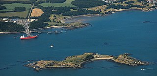
Inchcolm is an island in the Firth of Forth in Scotland. It was repeatedly attacked by English raiders during the Wars of Scottish Independence, and was fortified during both World Wars to defend nearby Edinburgh. Inchcolm now attracts visitors to its former Augustine Abbey.

Inchgarvie or Inch Garvie is a small, uninhabited island in the Firth of Forth. On the rocks around the island sit four caissons that make up the foundations of the Forth Bridge.
North Queensferry railway station is a railway station in the village of North Queensferry, Fife, Scotland. The station is managed by Abellio ScotRail and is on the Fife Circle Line, 11 1⁄4 miles (18.1 km) northwest of Edinburgh Waverley.

Port Edgar is a marina on the southern shore of the Firth of Forth, immediately west of the Forth Road Bridge and the town of South Queensferry, in West Lothian, Scotland. Originally a naval base, HMS Lochinvar, Port Edgar is now a busy marina with a sailing school and 300 berths. The Edgar commemorated in the name is Edgar Aetheling, the brother of Queen Margaret.

The Islands of the Forth are a group of small islands located in the Firth of Forth and in the estuary of the River Forth on the east coast of Scotland. Most of the group lie in the open waters of the firth, between the Lothians and Fife, with the majority to the east of the city of Edinburgh. Two islands lie further west in the river estuary.
The Slamannan and Borrowstounness Railway was a railway built in Scotland in 1848 to extend the Slamannan Railway to the harbour at Borrowstounness on the Firth of Forth, and to connect with the Edinburgh and Glasgow Railway. It was not commercially successful, but in recent years part of it was taken over by the Scottish Railway Preservation Society, which operates the Bo'ness and Kinneil Railway.
The Edinburgh and Northern Railway was a railway company authorised in 1845 to connect Edinburgh to both Perth and Dundee. It relied on ferry crossings of the Firth of Forth and the Firth of Tay, but despite those disadvantages it proved extremely successful. It took over a short railway on the southern shore of the Forth giving a direct connection to Edinburgh, and it changed its name to the Edinburgh, Perth and Dundee Railway.
Events from the year 1964 in Scotland.

The Forth Bridge is a cantilever railway bridge across the Firth of Forth in the east of Scotland, 9 miles west of central Edinburgh. Completed in 1890, it is considered as a symbol of Scotland, and is a UNESCO World Heritage Site. It was designed by the English engineers Sir John Fowler and Sir Benjamin Baker. It is sometimes referred to as the Forth Rail Bridge, although this has never been its official name.

Trinity Chain Pier, originally called Trinity Pier of Suspension, was built in Trinity, Edinburgh, Scotland in 1821. The pier was designed by Samuel Brown, a pioneer of chains and suspension bridges. It was intended to serve ferry traffic on the routes between Edinburgh and the smaller ports around the Firth of Forth, and was built during a time of rapid technological advance. It was well used for its original purpose for less than twenty years before traffic was attracted to newly developed nearby ports, and it was mainly used for most of its life for sea bathing. It was destroyed by a storm in 1898; a building at the shore end survives, much reconstructed, as a pub and restaurant called the Old Chain Pier.
Several mineral railways were constructed around Dunfermline in western Fife, Scotland, in the eighteenth century and later. Their purpose was to convey minerals to market from the outcropping coal deposits that had encouraged industrial activity in the area from an early date.
The Dunfermline and Queensferry Railway was a railway company founded to form part of a rail and ferry route between Dunfermline and Edinburgh, in Scotland. It was authorised in 1873 and its promoters had obtained informal promises from the larger North British Railway that the NBR would provide financial help, and also operate the ferry and the necessary railway on the southern side of the Firth of Forth.
The Forth Bridge approach railways were railway lines constructed in the period 1887 to 1890 to form new main lines on the opening of the Forth Bridge at the Queensferry crossing. Until then, only local branch lines approached the location. The North British Railway built new main lines and upgraded some existing lines.