Gallery
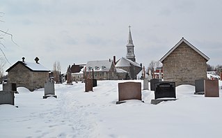
 Hobkirk church
 Rule Water
 Hobkirk church
 The Rule Water
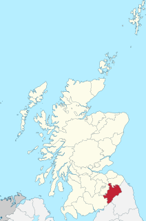
Hobkirk (Scottish Gaelic : Eaglais Ruail) is a village and civil parish in the Scottish Borders area of Scotland, by the Rule Water, south-west of Jedburgh and south-east of Hawick.
Other places nearby include Abbotrule, Bonchester Bridge, Camptown, Hallrule, Bedrule, Southdean, Denholm, Rubers Law, and the Wauchope Forest.
Hobkirk was sometimes known as "Hopekirk". Part of the parish of Abbotrule was annexed to Hobkirk in 1777. The present parish church was built in 1869.
Robert Elliott (1762–1810) was born in Hobkirk and emigrated to Louiseville, Quebec. His great-great granddaughter was Grace Elliott (1890–1973), mother of 15th Canadian Prime Minister Pierre Elliott Trudeau (1919–2000) and paternal grandmother of 23rd Canadian Prime Minister Justin Trudeau (b. 1971). [1]


Joseph Philippe Pierre Yves Elliott Trudeau, also referred to by his initials PET, was a Canadian lawyer and politician who served as the 15th prime minister of Canada from 1968 to 1979 and from 1980 to 1984. He also briefly served as the leader of the Opposition from 1979 to 1980. He served as leader of the Liberal Party of Canada from 1968 to 1984.

Margaret Joan Trudeau is a Canadian author, actress, photographer, former television talk show hostess, and social advocate for people with bipolar disorder, with which she is diagnosed. She is the former wife of Pierre Trudeau, 15th prime minister of Canada; they divorced in 1984, during his final months in office. She is the mother of Justin Trudeau, the 23rd and current prime minister of Canada; the journalist and author Alexandre "Sacha" Trudeau; and the deceased Michel Trudeau. She is the first woman in Canadian history to have been both the wife and the mother of prime ministers.
Roxburghshire or the County of Roxburgh is a historic county and registration county in the Southern Uplands of Scotland. It borders Dumfriesshire to the west, Selkirkshire and Midlothian to the north-west, and Berwickshire to the north. To the south-west it borders Cumberland and to the south-east Northumberland, both in England.
Saint-Constant is a city in southwestern Quebec, Canada. It is located on the south shore of Montreal in the Roussillon Regional County Municipality of the Montérégie region. The population as of the Canada 2016 Census was 27,359.

Cramond Village is a village and suburb in the north-west of Edinburgh, Scotland, at the mouth of the River Almond where it enters the Firth of Forth.

Abbotrule is a hamlet south of the B6357 road, in the Scottish Borders area of Scotland on the Rule Water. Places nearby include Bedrule, Hallrule, Spittal-on-Rule, Ruletownhead, Bonchester Bridge, Denholm, Southdean, Hobkirk, Ferniehirst Castle and the Wauchope Forest.

Jedburgh Abbey, a ruined Augustinian abbey which was founded in the 12th century, is situated in the town of Jedburgh, in the Scottish Borders 10 miles (16 km) north of the border with England at Carter Bar.

Eddleston is a small village and civil parish in the Scottish Borders area of Scotland. It lies 4 miles (6.4 km) north of Peebles and 9 miles (14 km) south of Penicuik on the A703, which passes through the centre of the village. Nearby is the Great Polish Map of Scotland, a large terrain map. The Eddleston Water runs through the village.

Southdean is a hamlet in the Scottish Borders area of Scotland, on the A6088, by the Jed Water and in the Wauchope Forest area. Other settlements nearby include Abbotrule, Bedrule, Bonchester Bridge, Denholm, Hallrule, Hobkirk and the Swinnie Forest.

Prestwick South Parish Church is located in South Prestwick, South Ayrshire, Scotland. It is a Parish Church in the Church of Scotland and within the Presbytery of Ayr. It is a category B listed building.

Kirkton is a village in the Scottish Borders area of Scotland, off the A6088, near Hawick. Grid Ref. NT5413.

Camptown is a small settlement on the A68, in the Scottish Borders area of Scotland, 5m (8 km) south of Jedburgh, and the same distance south to Carter Bar. The village lies on the course of the Jed Water, and the remains of a peel tower are close by at Edgerston.

Edgerston is a village and an estate about 4 miles (6.4 km) north of the Anglo-Scottish border, and 8 miles (13 km) south of Jedburgh in the Scottish Borders area of Scotland in the former Roxburghshire.

Bedrule is a hamlet and civil parish in the historic county of Roxburghshire in the Scottish Borders area of Scotland. The hamlet lies on the east side of the Rule Water, which gave the village its name, about 4 miles west of Jedburgh. It lies south of the A698 between Hawick and Jedburgh. Other local place-names based on the river include Hallrule, Abbotrule, Ruletownhead and Spittal-on-Rule. Larger settlements include Bonchester Bridge and Denholm, as well as Hawick and Jedburgh.

Wauchope Forest is a forest on the Rule Water, in the Scottish Borders area of Scotland, south of Hawick, and including the A6088, the A68 and the B6357, as well as Newcastleton, Bonchester Bridge, Hobkirk, Southdean, Hyndlee, Carter Bar, Abbotrule, Chesters, Scottish Borders.
The Rule Water is a river in the Scottish Borders area of Scotland, and a tributary of the River Teviot. The Rule Water rises in Wauchope Forest and passes Hobkirk, Bonchester Bridge, Hallrule, Abbotrule, and Bedrule until it joins the River Teviot at Spittal-on-Rule.

Rubers Law is a prominent, conical hill in the Scottish Borders area of south-east Scotland. It stands on the south bank of the River Teviot, between the towns of Hawick and Jedburgh, and south of the village of Denholm. The hill is on the border between the historic parishes of Cavers and Hobkirk, and until 1975 it stood within the historic county of Roxburghshire.

Hallrule is a hamlet on the B6357 road, in the Scottish Borders area of Scotland, on the Rule Water, near Abbotrule, Bedrule Bonchester Bridge, Denholm, Hobkirk, Ruletownhead and to the south, the Wauchope Forest. The village's name in 1502 was Hawroull, and Hallrule Tower was held by George Turnbull. It was burned in 1523 and in 1544.

Castleton is a civil parish in the Scottish Borders area of Scotland, in the former Roxburghshire, in the extreme south of the Borders area. It is bounded by Northumberland (England), Dumfries and Galloway, and the parishes of Hobkirk, Southdean and Teviothead. The village of Castleton was commenced in 1793. It was built as a result of the land clearances in the 1790s when people were forced to move from Old Castleton village. While the parish retained the name Castleton, the village later became identified as New Castleton or Newcastleton. The parish is also known by its older name Liddesdale
| Wikimedia Commons has media related to Hobkirk . |
Coordinates: 55°23′24″N2°39′15″W / 55.38998°N 2.65414°W
| | This Scottish Borders location article is a stub. You can help Wikipedia by expanding it. |