
The 1958 Atlantic hurricane season included every tropical cyclone either affecting or threatening land. There were ten named storms as well as one pre-season tropical storm. Seven of the storms became hurricanes, including five that were major hurricanes, or the equivalent of a Category 3 on the Saffir-Simpson scale. The strongest storm was Hurricane Helene, which became a strong Category 4 hurricane with 150 mph (240 km/h) winds and a barometric pressure of 930 millibars (27 inHg) while just offshore the southeastern United States.
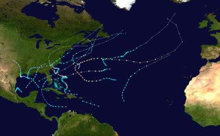
The 1959 Atlantic hurricane season featured near normal tropical cyclone activity overall. The season officially began on June 15, 1959 and lasted until November 15, 1959. These dates historically described the period in each year when most tropical cyclogenesis occurs in the Atlantic basin. However, the formation of a tropical cyclone is possible at any time of the year, as shown in 1959, by the formation of Tropical Storm Arlene on May 28. Arlene struck Louisiana and brought minor flooding to the Gulf Coast of the United States. The next tropical storm, Beulah, formed in the western Gulf of Mexico and brought negligible impact to Mexico and Texas. Later in June, an unnamed hurricane, caused minor damage in Florida, and then devastated parts of Maritime Canada, resulting in what became known as the Escuminac disaster. Hurricane Cindy brought minor impact to The Carolinas. In late July, Hurricane Debra produced flooding in the state of Texas. Tropical Storm Edith in August and Hurricane Flora in September caused negligible impact on land.

The 1960 Atlantic hurricane season was the least active season since 1952. The season officially began on June 15, and lasted until November 15. These dates conventionally delimit the period of each year when most tropical cyclones form in the Atlantic basin. The first system, an unnamed storm, developed in the Bay of Campeche on June 22. It brought severe local flooding to southeastern Texas and was considered the worst disaster in some towns since a Hurricane in 1945. The unnamed storm moved across the United States for almost a week before dissipating on June 29. In July, Hurricane Abby resulted in minor damage in the Leeward Islands, before impacting a few Central American counties — the remnants of the storm would go on to form Hurricane Celeste in the East Pacific. Later that month, Tropical Storm Brenda caused flooding across much of the East Coast of the United States. The next storm, Hurricane Cleo, caused no known impact, despite its close proximity to land.

The 1962 Atlantic hurricane season featured Hurricanes Daisy and Ella – two tropical cyclones that showed the latest dates for the fourth and fifth named storms on record since tropical cyclones were first named in the North Atlantic ocean, starting in 1950, when they both formed on September 29 and October 14. On the same hand, it was the least active since 1939, with only five named storms. Although the season officially began on June 15, the first named storm did not form until August 26, the third-latest date. Hurricane Alma brushed the Outer Banks before becoming extratropical southeast of New England, destroying hundreds of boats and producing beneficial rainfall. In late August, Tropical Storm Becky developed unusually far east in the Atlantic Ocean, becoming the easternmost storm on record to recurve to the northeast. Celia followed in the September, forming east of the Lesser Antilles and executing a loop near Bermuda before dissipating. Hurricane Daisy, the latest fourth named storm, was the costliest of the season, leaving about $1.1 million in damage in New England (1962 USD). The storm dropped the highest rainfall total on record in Maine, and its precipitation caused 22 traffic fatalities. The final hurricane – Ella – the latest fifth named storm – was also the strongest, remaining offshore of the eastern United States but causing two deaths.

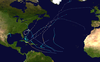
The 1963 Atlantic hurricane season featured one of the deadliest tropical cyclones on record in the Atlantic basin: Hurricane Flora. The season officially began on June 15, and lasted until November 15. These dates conventionally delimit the period of each year when most tropical cyclones form in the Atlantic basin. It was a slightly below average season in terms of tropical storms, with a total of ten nameable storms. The first system, an unnamed tropical storm, developed over the Bahamas on June 1. In late July, Hurricane Arlene, developed between Cape Verde and the Lesser Antilles. The storm later impacted Bermuda, where strong winds resulted in about $300,000 (1963 USD) in damage. Other storms such as hurricanes Beulah and Debra, as well as an unnamed tropical storm, did not impact land. During the month of September, Tropical Storm Cindy caused wind damage and flooding in Texas, leaving three deaths and approximately $12.5 million in damage. Hurricane Edith passed through the Lesser Antilles and the eastern Greater Antilles, causing 10 deaths and about $43 million in damage, most of which occurred on Martinique.

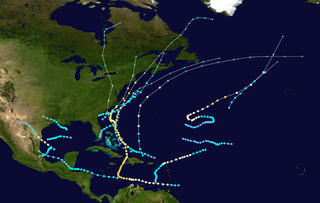
The 1991 Atlantic hurricane season was the first season since 1984 in which no hurricanes developed from tropical waves, which are the source for most North Atlantic tropical cyclones. The hurricane season officially began on June 1, and ended on November 30. It was the least active in four years due to higher than usual wind shear across the Atlantic Ocean. The first storm, Ana, developed on July 2 off the southeast United States and dissipated without causing significant effects. Two other tropical storms in the season – Danny and Erika – did not significantly affect land. Danny dissipated east of the Lesser Antilles, and Erika passed through the Azores before becoming extratropical. In addition, there were four non-developing tropical depressions. The second depression of the season struck Mexico with significant accompanying rains.

Hurricane Gloria was a powerful hurricane that caused significant damage along the east coast of the United States and in Atlantic Canada during the 1985 Atlantic hurricane season. It was the first significant tropical cyclone to strike the northeastern United States since Hurricane Agnes in 1972 and the first major storm to affect New York City and Long Island directly since Hurricane Donna in 1960. Gloria was a Cape Verde hurricane originating from a tropical wave on September 16 in the eastern Atlantic Ocean. After remaining a weak tropical cyclone for several days, Gloria intensified into a hurricane on September 22 north of the Lesser Antilles. During that time, the storm had moved generally westward, although it turned to the northwest due to a weakening of the ridge. Gloria quickly intensified on September 24, and the next day reached peak winds of 145 mph (233 km/h). The hurricane weakened before striking the Outer Banks of North Carolina on September 27. Later that day, Gloria made two subsequent landfalls on Long Island and across the coastline of western Connecticut, before becoming extratropical on September 28 over New England. The remnants moved through Atlantic Canada and went on to impact Western Europe, eventually dissipating on October 4.
The 1954 Atlantic hurricane season was an above-average Atlantic hurricane season in terms of named storms, with 16 forming. Overall, the season resulted in $751.6 million in damage, the most of any season at the time. The season officially began on June 15, and nine days later the first named storm developed. Hurricane Alice developed in the Gulf of Mexico and moved inland along the Rio Grande, producing significant precipitation and record flooding that killed 55 people. Activity was slow until late August; only Barbara, a minimal tropical storm, developed in July. In the span of two weeks, hurricanes Carol and Edna followed similar paths before both striking New England as major hurricanes. The latter became the costliest hurricane in Maine's history.

Hurricane Edna was a deadly and destructive major hurricane that impacted the United States East Coast in September of the 1954 Atlantic hurricane season. It was one of two hurricanes to strike Massachusetts in that year, the other being Hurricane Carol. The fifth tropical cyclone and storm of the season, as well as the fourth hurricane and second major hurricane, Edna developed from a tropical wave on September 2. Moving towards the north-northwest, Edna skirted the northern Leeward Islands as a tropical depression before turning more towards the west. The depression attained tropical storm status to the east of Puerto Rico and strengthened further to reach hurricane status by September 7. The storm rapidly intensified and reached its peak intensity of 125 mph (205 km/h) north of the Bahamas before weakening to Category 2 status near landfall in Massachusetts on September 11. Edna transitioned into an extratropical cyclone in Atlantic Canada before its remnants dissipated in the northern Atlantic.

Hurricane Kate was the final in a series of tropical cyclones to impact the United States during 1985. It was the eleventh named storm, seventh hurricane, and third major hurricane of the 1985 Atlantic hurricane season, Kate originated from the interaction of an upper-level trough and tropical wave northeast of Puerto Rico on November 15. Though the system tracked erratically during the first hours of its existence, the intensification of a region of high pressure to the cyclone's north caused Kate to turn westward. A favorable atmospheric pattern allowed the newly developed system to intensify to hurricane intensity on November 16, and further to Category 2 intensity three days later.

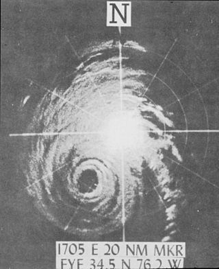
Hurricane Esther was the first large tropical cyclone to be discovered by satellite imagery. The fifth tropical cyclone, named storm, and hurricane of the 1961 Atlantic hurricane season, Esther developed from an area of disturbed weather hundreds of miles west-southwest of the southernmost Cape Verde Islands on September 10. Moving northwestward, the depression strengthened into Tropical Storm Esther on September 11, before reaching hurricane intensity on the following day. Early on September 13, Esther curved westward and deepened into a major hurricane. The storm remained a Category 3 hurricane for about four days and gradually moved in a west-northwestward direction. Late on September 17, Esther strengthened into a Category 5 hurricane with sustained winds of 160 mph (260 km/h) on September 18. The storm curved north-northeastward on September 19, while offshore of North Carolina. Esther began to weaken while approaching New England and fell to Category 3 intensity on September 21. The storm turned eastward early on the following day, and rapidly weakened to a tropical storm.
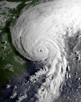
Hurricane Helene was the most intense tropical cyclone of the 1958 Atlantic hurricane season. The eighth tropical storm and fourth hurricane of the year, Helene was formed from a tropical wave east of the Lesser Antilles on September 21, 1958. Moving steadily westward, the storm slowly intensified, attaining hurricane strength on September 24. As conditions became increasingly favorable for tropical cyclone development, Helene began to rapidly intensify. Nearing the United States East Coast, the hurricane quickly attained Category 4 intensity on September 26, before it subsequently reached its peak intensity with maximum sustained winds of 150 mph (240 km/h) and a minimum barometric pressure of 930 mbar. The intense hurricane came within 10 mi (16 km) of Cape Fear, North Carolina before recurving out to sea. Accelerating northward, Helene gradually weakened, and transitioned into an extratropical cyclone as it passed over Newfoundland on September 29. Helene's extratropical remnants traversed eastwards across the Atlantic Ocean before dissipating near Great Britain on October 4.
Hurricane Bob was one of the costliest hurricanes in New England history. The second named storm and first hurricane of the 1991 Atlantic hurricane season, Bob developed from an area of low pressure near The Bahamas on August 16. The depression steadily intensified, and became Tropical Storm Bob late on August 16. Bob curved north-northwestward as a tropical storm, but re-curved to the north-northeast after becoming a hurricane on August 17. As such, it brushed the Outer Banks of North Carolina on August 18 and August 19, and subsequently intensified into a major hurricane. After peaking in intensity with maximum sustained winds of 115 mph (185 km/h), Bob weakened slightly as it approached the coast of New England.

Hurricane Able was the only hurricane to make landfall in the United States in the 1952 season. Forming on August 18 off the west coast of Africa, Able moved generally west- to west-northwestward for much of its duration. It was first observed by the Hurricane Hunters on August 25 to the north of the Lesser Antilles. Two days later, Able attained hurricane status, and on August 30 it turned sharply to the north-northwest in response to a cold front. The hurricane reached peak winds of 100 mph (160 km/h) just prior to moving ashore near Beaufort, South Carolina on August 31. Although it quickly weakened below hurricane force, Able maintained tropical storm force for almost two days over land, eventually dissipating over Maine on September 2.

Hurricane Alma saw the latest development of the first storm since 1941. The first named storm of the 1962 Atlantic hurricane season, Alma formed from a tropical wave located offshore South Florida on August 26. Initially a tropical depression, it subsequently moved inland over South Florida. Impact in the state was minor, generally limited to light rainfall and rough seas. Early on August 27, the depression reemerged into the Atlantic Ocean and strengthened into Tropical Storm Alma later that day. Thereafter, it moved northeastward and remained offshore the East Coast of the United States. Alma strengthened into a hurricane on August 28, while located offshore the Outer Banks of North Carolina. In the eastern portion of the state, strong winds downed electrical poles, which caused power outages. Storm tides caused erosion in some areas. Damage in North Carolina reached $35,000 (1962 USD).

Hurricane Cindy impacted the Carolinas, the Mid-Atlantic states, New England, and the Canadian Maritime Provinces during the 1959 Atlantic hurricane season. The third storm of the season, Cindy originated from a low-pressure area associated with a cold front located east of northern Florida. The low developed into a tropical depression on July 5 while tracking north-northeastward, and became Tropical Storm Cindy by the next day. Cindy turned westward because of a high-pressure area positioned to its north, and further intensified into a weak hurricane off the coast of the Carolinas on July 8. Early on July 9, Cindy made landfall near McClellanville, South Carolina, and re-curved to the northeast along the Fall Line as a tropical depression. It re-entered the Atlantic on July 10, quickly restrengthening into a tropical storm while it began to move faster. On July 11, Cindy passed over Cape Cod, while several other weather systems helped the storm maintain its intensity. Cindy transitioned into an extratropical cyclone on July 12 as it neared the Canadian Maritime Provinces.


