The Lagoon contains five state parks, four federal wildlife refuges and a national seashore.[2]
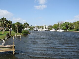
The Lagoon varies in width from 0.5 to 5 miles (0.80 to 8.05km) and averages 4 feet (1.2m) in depth.[3]
History
During glacial periods, the ocean receded. The area that is now the lagoon was grassland, 30 miles (48km) from the beach. When the glaciers melted, the sea rose. The lagoon remained as captured water.[4]
The indigenous people who lived along the lagoon thrived on its fish and shellfish. This was determined by analyzing the middens they left behind, piled with refuse from clams, oysters, and mussels.[4]
The Indian River Lagoon was originally known on early Spanish maps as the Rio de Ais, after the Ais Indian tribe, who lived along the east coast of Florida. An expedition in 1605 by Alvero Mexia resulted in the mapping of most of the lagoon. Original place names on the map included Los Mosquitos (the Mosquito Lagoon and the Halifax River), Haulover (current Haulover Canal area), Ulumay Lagoon (Banana River) Rio d' Ais (North Indian River), and Pentoya Lagoon (Indian River Melbourne to Ft. Pierce)[5]
Early European settlers drained the swamps to raise pineapples and citrus. They dug canals discharging fresh water into the lagoon, five times the historical volume.[4]
Prior to the arrival of the railroad, the river was an essential transportation link.[6]
In 1896 and 1902, there were fish kills in the lagoon from gas from the muck below.[7]
The advent of the automobile, starting in the 1930s, resulted in causeways which diverted the sluggish flow of the waterway. Huge population influx resulted in sewage, and stormwater runoff from roadways, polluting the lagoon.[4]
From 1989 to 2013, the population along the lagoon increased 50% to 1.6 million people.[8]
Indian River, the main body of water, from the north border between Volusia and Brevard Counties along the western shore of Merritt Island, southward to St. Lucie Inlet.
Banana River, an offshoot of the Indian River, northward making up the eastern shore of Merritt Island.
Crane Creek is a 3.3-mile (5.3km) long tributary of the Indian River in Melbourne, Florida.
Turkey Creek Sanctuary is a county wildlife reserve and nature trail system located along the shores of Turkey Creek. A tributary of the Indian River, in Palm Bay Florida.
Hobe Sound is the portion of the lagoon from St. Lucie Inlet to Jupiter Inlet.
For water quality measurement, the non-profit Marine Resources Council has divided the lagoon into 4 major divisions, with a total of ten subdivisions:[12]
Natural history
The Indian River Lagoon is North America's most diverse estuary, with more than 2100 species of plants and 2200 animals. The diversity is the result of being located near a climate boundary, 5 miles (8.0km) from the Gulf Stream. Migratory ocean fish swimming nearby, were swept into the lagoon.[4]
Fauna
The lagoon contains 35 species listed as threatened or endangered — more than any other estuary in North America.[3][13] The lagoon has about 2,500 types of animals in it.[clarification needed] It serves as a spawning and nursery ground for different species of oceanic and lagoon fish and shellfish. The lagoon also has one of the most diverse bird populations anywhere in America.
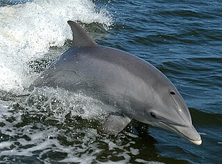
Nearly 1/3 of the nation's manatee population lives here or migrates through the Lagoon seasonally. There was a mass death of manatees in 2021 due to the loss of seagrass, caused by leaks from septic systems and overuse of fertilizers.[14]
Nine-banded armadillos comprise one of the 34 mammals in the area. It is a 1920s immigrant from the Southwestern United States. In 2016 a Right whale with her calf entered the lagoon by mistake and safely exited to the ocean.[15]
Seagrass is a critical component to the overall health of the lagoon.[21] By 1990, it had surpassed levels reached in 1943. The lagoon also contains night-blooming cereus.[15]
95% of the seagrass, the main diet of manatees, disappeared by 2017 after an algae bloom fuel by fertilizers.[14]
Lagoon modifications
In 1916, the St. Lucie Canal (C-44) diverts excess nutrient-rich water from Lake Okeechobee into the South Lagoon. While this helps prevent life-threatening flooding in the Okeechobee area, it creates toxic blooms after entering the Lagoon, a threat to flora, fauna, and humans. This situation is proving difficult to address in the 21st century.[4]
From 1913 to 2013, activity by humans has increased the watershed for the lagoon from 572,000 acres (231,000ha) to 1,400,000 acres (570,000ha) increasing runoff of freshwater and nutrients from farms. Both have been detrimental to lagoon health.[8] The wetlands are needed to cleanse the lagoon. About 40,000 acres (16,000ha) of land were lost to mosquito control and have been restored, but by 2013, recovery was incomplete.[8]
Mangroves are important to marine life. Between the 1940s and 2013, 85% of them had been removed for housing development.
In 1990, the Florida Legislature passed the Indian River Lagoon Act, requiring most sewer plants to stop discharging into the lagoon by 1996. Some sports fish rebounded in population in the 1990s when gill nets were banned and pollution in the lagoon was reduced. In 1995 the seagrass covered over 100,000 acres (40,000ha).[21][22]
The 1993–1996 data base used to track the movement of water through the St. Lucie Estuary and into Indian River Lagoon is described in Smith (2007). This includes daily mean discharge rates for the 16 gauged canals emptying into the St. Lucie Estuary and Indian River Lagoon, predicted shelf tides, and wind speeds and directions recorded along the west side of the lagoon at about 27°32'N (corresponding to Segment 11 of the model).[23]
In 2007, concerns were raised about the future of the lagoon system, especially in the southern half where frequent freshwater discharges seriously threatened water quality, decreasing the salinity needed by many fish species, and have contributed to large algae blooms promoted by water saturated with plant fertilizers.[citation needed] In the mid 1990s, the lagoon has been the subject of research on light penetration for photosynthesis in submerged aquatic vegetation.[21]
In 2010, 3,300,000 pounds (1,500,000kg) of nitrogen and 475,000 pounds (215,000kg) of phosphorus entered the lagoon.[24]
In 2011, a superbloom of phytoplankton resulted in the loss of 32,000 acres (13,000ha) of lagoon seagrass. In 2012, a brown tide bloom fouled the northern lagoon. The county has approval for funds to investigate these unusual blooms to see if they can be prevented.[25]
Catches of blue crabs dropped unevenly from 4,265,063 pounds (1,934,600kg) in 1987 to 389,795 pounds (176,808kg) in 2012, but with high catches in 1998, 1991, alternating with low catch years. These crabs require 2% salt content in the water to survive. A drought increases the salt content and heavy rainfall decreases it. Both of these conditions have recurred over the past decades and are believed to have had an adverse effect on the crab population.[26]
In 2013, algae blooms and loss of sea grass destroyed all gains.[8] In 2013, four major problems with lagoon water quality were identified. 1) Excess nitrogen and phosphorus from runoff from the application of fertilizer; 2) an estimated 8 to 11% septic tank failures of tens of thousands of septic tanks in the county. 3) Muck from construction, farming, erosion and dead plants find their way to the bottom of the lagoon, preventing growth and consuming vital oxygen essential to marine flora and fauna; 4) Invasive species, including the Asian green mussel, South American charru mussel, and the Australian spotted jellyfish, eat clams and fish larvae.[27]
In 2016, there were an estimated 300,000 septic tanks in the five-county area bordering the Lagoon.[28] At one time, sewer plants were worse polluters. In 1986, there were 46 sewer plants along the 156 miles (251km) lagoon. They discharged about 55,000,000 US gallons (210,000,000L; 46,000,000impgal) daily into the estuary. The state ended most sewer plant pollution by 1995.[29]
The worst fish kill to date occurred in March 2016, with 30 species impacted. A brown tide bloom, caused by the algae species Aureoumbra lagunensis,[30] was blamed for the low oxygen levels. The algae growth originated in the no-motor zone of the Merritt Island National Wildlife Refuge.[31]
In 2018, lagoon health is better near ocean inlets. Pollution is worse in areas near no inlets, such as the Mosquito Lagoon, North IRL, and the Banana River.[4]
Economy
According to the Florida Oceanographic Society, nearly 1 million people live and work in the Indian River Lagoon region. The Lagoon accounts for $300 million in fisheries revenues, includes a $2.1 billion citrus industry, and generates more than $300 million in boat and marine sales annually.[2]
In 2007, visitors spent an estimated 3.2 million person-days in recreation on the lagoon.[32]
In 2008, Hazen and Sawyer, P.C. submitted a report titled "Indian River Lagoon Economic Assessment and Analysis Update" to the Indian River Lagoon National Estuary Program, St. Johns River Water Management District. The report described the estimated 2007 recreational uses and economic value of the Indian River Lagoon to residents and visitors of the five counties that comprise the Lagoon system. The sum of recreational expenditures and recreational use value was estimated at $2.1 billion.[33]
Brevard County is a county located in the east central portion of the U.S. state of Florida. As of the 2020 census, the population was 606,612, making it the 10th-most populated county in Florida. The official county seat is located in Titusville. Brevard County comprises the Palm Bay–Melbourne–Titusville, FL Metropolitan Statistical Area. It is located along the east Florida coast and bordered by the Atlantic Ocean.
Indian River County is a county located in the southeastern and east-central portions of the U.S. state of Florida. As of the 2020 census, the population was 159,788. Its seat is Vero Beach. It is Florida's 7th richest county and in 2000 was the 87th richest county in the U.S. by per capita income.
St. Lucie County is located in the southeastern portion of the U.S. state of Florida. As of the 2020 census, the population was 329,226. The county's seat is Fort Pierce, while the largest city is Port St. Lucie, making up 62% of the county's population. St. Lucie County is the principal county of the Port St. Lucie, FL Metropolitan Statistical Area.
Bottlenose dolphins are toothed whales in the genus Tursiops. They are common, cosmopolitan members of the family Delphinidae, the family of oceanic dolphins. Molecular studies show the genus contains three species: the common bottlenose dolphin, the Indo-Pacific bottlenose dolphin, and Tamanend's bottlenose dolphin. Others, like the Burrunan dolphin, may be alternately considered their own species or be subspecies of T. aduncus. Bottlenose dolphins inhabit warm and temperate seas worldwide, being found everywhere except for the Arctic and Antarctic Circle regions. Their name derives from the Latin tursio (dolphin) and truncatus for the truncated teeth.
The common bottlenose dolphin or Atlantic bottlenose dolphin is one of three species of bottlenose dolphin in the genus Tursiops. The common bottlenose dolphin is a very familiar dolphin due to the wide exposure it receives in captivity in marine parks and dolphinariums, and in movies and television programs. Spending their entire life in water, common bottlenose dolphins inhabit temperate and tropical oceans throughout the world, absent only from polar waters. While formerly known simply as the bottlenose dolphin, this term is now applied to the genus Tursiops as a whole. As considerable genetic variation has been described within this species, even between neighboring populations, many experts think additional species may be recognized.
Lake Okeechobee is the largest freshwater lake in the U.S. state of Florida. It is the tenth-largest natural freshwater lake among the 50 states of the United States and the second-largest natural freshwater lake contained entirely within the contiguous 48 states, after Lake Michigan.
Sebastian Inlet State Park is a Florida state park located 10 miles south of Melbourne Beach and 6 miles north of Vero Beach in Florida. The park lies on both sides of the Sebastian Inlet, which forms the boundary between Brevard and Indian River counties. The land for the park was acquired by the state of Florida in 1971. In 2010, it was the second most visited state park in Florida.
Sebastian Inlet, located in Sebastian Inlet State Park in Brevard County, Florida and Indian River County, Florida, offers surfing and fishing opportunities. It is off State Road A1A just 12 miles north of Vero Beach. There are annual surf tournaments, professional and amateur. Visitors fish there, particularly for Snook and Redfish.
The Treasure Coast is a region in the southeast of the U.S. state of Florida. It borders the Atlantic Ocean and comprises Indian River, Martin, and St. Lucie counties. The region, whose name refers to the Spanish Treasure Fleet that was lost in a 1715 hurricane, evidently emerged from residents' desire to distinguish themselves from the Gold Coast to the south.
Laguna de Términos is the largest tidal lagoon by volume located entirely on the Gulf of Mexico, as well as one of the most biodiverse. Exchanging water with several rivers and lagoons, the Laguna is part of the most important hydrographic river basin in Mexico. It is important commercially, as well as ecologically by serving as a refuge for extensive flora and fauna; its mangroves play an important role as a refuge for migratory birds.
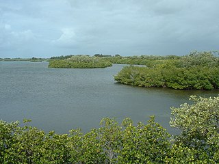
Mosquito Lagoon is a body of water located on the east coast of Florida in Brevard and Volusia counties. It is part of the Indian River Lagoon system and the Atlantic Intracoastal Waterway. It extends from the Ponce de Leon Inlet to a point north of Cape Canaveral, and connects to the Indian River via the Haulover Canal. The Mosquito Lagoon Aquatic Preserve includes 4,740 acres (1,920 ha) in the northern end of the lagoon. The preserve originally extended to the southern end of the lagoon, but close to two-thirds of the preserve in the central and southern lagoon were transferred to the Federal government, and is now part of the Canaveral National Seashore. The cities of New Smyrna Beach and Edgewater, the Merritt Island National Wildlife Refuge and the Kennedy Space Center adjoin the lagoon.
The Indian River is a 121-mile (195 km) long brackish lagoon in Florida. It is part of the Indian River Lagoon system, which in turn forms part of the Atlantic Intracoastal Waterway. It was originally named Rio de Ais after the Ais Indian tribe, who lived along the east coast of Florida, but was later given its current name.
The Banana River is a 31-mile-long (50 km) lagoon that lies between Cape Canaveral and Merritt Island in Brevard County, Florida in the United States. It is part of the Indian River Lagoon system, and connects at its south end to the Indian River; it is the only part of the lagoon system not in the Intracoastal Waterway. It also has an outlet to the Atlantic Ocean via a lock into Port Canaveral. The lagoon includes salt marshes, mangrove swamps, seagrass beds, drift algae, oyster bars, tidal flats, and spoil islands, providing habitats for many marine species. These are brackish waters mixed of salt and fresh water; waist deep with a soft bottom sand/grass. Commercial and recreational activities in the lagoon generate more than US$ 800 million annually for the local economy.
The Haulover Canal is a waterway north of Merritt Island, Florida, near the former site of Allenhurst, that connects Mosquito Lagoon with the Indian River, and is part of the Intracoastal Waterway.
Lake Poinsett is a lake in Brevard County, Florida, United States, near Rockledge and Cocoa, with small portions in Orange County and Osceola County. It is the second-largest lake in Brevard County, after Lake Washington, though it is actually the smallest lake in Osceola County. It is the widest lake in Brevard County, with a distance of 5 miles (8 km) at its widest point. At the eastern portion of the lake, a channel connects the lake to Lake Florence and Barnett Lake.
The St. Lucie River is a 35-mile-long (56 km) estuary linked to a coastal river system in St. Lucie and Martin counties in the U.S. state of Florida. The St. Lucie River and St. Lucie Estuary are an "ecological jewel" of the Treasure Coast, central to the health and well-being of the surrounding communities. The river is part of the larger Indian River Lagoon system, the most diverse estuarine environment in North America with more than 4,000 plant and animal species, including manatees, oysters, dolphins, sea turtles and seahorses.
Environmental issues in Brevard County in Florida United States are highlighted by the amount of waterline, the amount of wetlands, the quantity of residents and visitors to the area, as well as the usual threat to air quality from commuters. Assisting in this is the Florida Space Coast Clean Cities Coalition which is headquartered in Brevard.
Eau Gallie River is a 3.9-mile-long (6.3 km) river in Eau Gallie, Florida, United States. It is a tributary of the Indian River, with its mouth near Hawthorne Point.
The Atlantic needlefish is a common demersal needlefish species common in marinas and other areas with minimal currents. Its extremely long jaw and body set this fish apart from other predators. Atlantic needlefish are found from Maine to Brazil and have been known to venture into fresh water for short periods.
The History of Brevard County can be traced to the prehistory of native cultures living in the area from pre-Columbian times to the present age. Brevard County is a county in the U.S. state of Florida, along the coast of the Atlantic Ocean. The geographic boundaries of the county have changed significantly since its founding. The county is named for Judge Theodore W. Brevard, an early settler, and state comptroller, and was originally named St. Lucie County until 1855. The official county seat has been located in Titusville since 1894, although most of the county's administration is performed from Viera.
References
↑ Harbor Branch Oceanographic Institution (2018). "Indian River Lagoon - Facts and Figures"(PDF). Fort Pierce, Florida: Florida Atlantic University. p.1. Retrieved 29 September 2018.
This page is based on this Wikipedia article Text is available under the CC BY-SA 4.0 license; additional terms may apply. Images, videos and audio are available under their respective licenses.