Irene Fischer

Last updated
Irene Fischer
IreneKFischer1966.png
Irene K. Fischer, from a 1966 publication of the United States Army
Born
Irene Kaminka Fischer

July 27, 1907 (1907-07-27)
DiedOctober 22, 2009 (2009-10-23) (aged 102)
SpouseEric Erich Fischer [1]
Children2 [1]
Scientific career
Fields Geodesy
Mathematics

Irene Kaminka Fischer (born July 27, 1907, in Vienna, Austria, died October 22, 2009, in Boston) was an Austrian-American mathematician and geodesist. She was a member of the National Academy of Engineering, a Fellow of the American Geophysical Union, and inductee of the National Imagery and Mapping Agency Hall of Fame. Fischer became one of two internationally known women scientists in the field of geodesy during the golden age of the Project Mercury and the Apollo program. Her Mercury datum (or Fischer ellipsoid 1960 and 1968), [2] [3] as well as her work on the lunar parallax, were instrumental in conducting these missions. "In his preface to the ACSM publication, Fischer's former colleague, Bernard Chovitz, referred to her as one of the most renowned geodesists of the third quarter of the twentieth century. Yet this fact alone makes her one of the most renowned geodesists of all times, because, according to Chovitz, the third quarter of the twentieth century witnessed "the transition of geodesy from a regional to a global enterprise." [4]

Contents

Early life and education

Born and educated in Vienna, she studied descriptive and projective geometry at the Technical University of Vienna and mathematics at the University of Vienna. [5] Her teachers Moritz Schlick and Hans Hahn were among the luminaries of the Vienna Circle; and her fellow students included physicist Victor Weisskopf, sociologist Paul Lazarsfeld, and social psychologist Marie Jahoda. Her father, Rabbi Armand Aharon Kaminka  [ de ], was head of the Maimonides Institute, and regularly led high holiday services at the famed Vienna Musikverein. He worked for the Alliance Israélite Universelle investigating pogroms in Eastern Europe and raised money in the U.S. and Western Europe to help victims.

In 1931 she married historian and geographer Eric Fischer, who helped introduce American, as distinct from British, history to Vienna. The Fischer family established and ran the 1843-founded Vienna Israelitische Kinderbewahranstalt, the first professional kindergarten and kindergarten teacher training school in Vienna, a place that also became a refuge for immigrants to Vienna from Eastern Europe.

Career

In 1939, the Fischers, with their young daughter, Gay, fled Nazi Austria, traveling by rail to Italy, by boat to Palestine and in 1941 by boat around East Africa and the Cape of Good Hope to Boston, where they lived with Eric Fischer's sister, mother, and brother in law, the physician Otto Ehrentheil and their two daughters. Looking for jobs, Fischer first worked as a seamstress’ assistant, then she graded blue books for Wassily Leontief at Harvard and for Norbert Wiener at the Massachusetts Institute of Technology (MIT). She also worked on stereoscopic projective geometry trajectories for John Rule at MIT. She taught mathematics at Brown and Nichols Preparatory School in Cambridge, and then at Sidwell Friends in Washington, D.C.

After World War II, and after her son, Michael, born in 1946, had reached school age, she found a job at the then Army Map Service, [6] now the National Geospatial-Intelligence Agency and the Army Geospatial Center in Potomac, Md., working under John A. O'Keefe in the Geodesy Branch and rising through the ranks to become the chief. Her twenty-five-year career at AMS, working on what became the World Geodetic System, produced over 120 scientific publications. On the side, she published a high school geometry textbook in 1965, one of her many endeavors as an educator. After retiring in 1975, she wrote a memoir of her scientific career that was first serialized in the ACSM Bulletin (an official publication of the American Congress on Surveying and Mapping, which then included five surveying and mapping professional organizations, 2004 – 06) covering the field of geodesy in the years 1951–1975, and discussing doing science in a man's world in a government bureaucracy. It was published as a book in 2005.

At the very beginning of her career in mathematics and geodesy, Dr. Fischer had quickly taught herself the basics of geodetic tables, datums, transformations, gravity studies, astronomy, long lines, flare triangulation, and guided missile ballistics. Her updates to geodetic science helped determine the parallax of the Moon. Irene Fischer was also intrigued by research into post glacial uplift, and her geoid studies went hand in hand with investigations of the lingering effects of the last ice age.

Fischer disagreed with the established figure for the oblateness of the Earth (the fraction by which the polar axis is foreshortened by the equatorial radius), which had remained unchallenged since 1924. She was forbidden to use her updated figures in her own work because that result was in disagreement with the accepted literature. However, after the flight of the first satellites, she was vindicated by the data and observations from the instruments, and she was allowed to amend her previous works with her newly derived figures. In commenting on the lack of faith others put on her research, Dr. Fischer goodheartedly quipped that the satellites had not accepted the accepted literature, either.

Legacy

A pioneer during a time when there were few women in surveying, in 1967, Fischer was the first Army Map Service employee, and only the third woman ever, to receive the Distinguished Civilian Service Award. Fischer was internationally known for her many publications and presentations on the size and shape of the earth, including the Department of Defense manual, “Latitude Functions Fischer 1960 Ellipsoid.”

Fischer wrote an autobiography (published 2005), entitled, Geodesy? What’s That? My Personal Involvement in the Age-Old Quest for the Size and Shape of the Earth, With a Running Commentary on Life in a Government Research Office. In addition, Fischer has written more than 120 other technical reports, articles and books in her fields of expertise, and many of her significant government reports are still classified today.

Winner of many federal government service awards, Fischer was awarded an honorary degree by the University of Karlsruhe, elected to the National Academy of Engineering, elected Fellow of the American Geophysical Union, and inducted into the National Imagery and Mapping Agency (NIMA) Hall of Fame; the Learning Center at the new campus of the National Geospatial-Intelligence Agency has been named in her honor.

Family

She and her family were active for many years at Temple Israel in Silver Spring, Md., where she also taught an adult class in basic Hebrew, and was an active member of a forty-year-long chavura (discussion group). When she moved to Rockville, Md., she joined Congregation Beth El and endowed a Biblical archeology lecture series in her husband's memory at the Rockville Jewish Community Center. In Israel, where many family members live, she and her husband endowed fellowships to a technical college. In 2001, she moved back to Brighton, Mass., three blocks from where she had first lived as an immigrant in 1941. In 2007, she celebrated her 100th birthday, and her children told the packed and rapt audience of her retirement community about her career. She is survived by her daughter Gay Fischer of Oberlin, Ohio, her son Michael M. J. Fischer and daughter-in-law Susann L. Wilkinson of Somerville, Mass., and many nephews and nieces, the children and grandchildren of her two brothers in Israel, and of her husband's sister in New England.

Publications

See also

Related Research Articles

<span class="mw-page-title-main">Geodesy</span> Science of measuring the shape, orientation, and gravity of the Earth and other astronomical bodies

Geodesy is the science of measuring and representing the geometry, gravity, and spatial orientation of the Earth in temporally varying 3D. It is called planetary geodesy when studying other astronomical bodies, such as planets or circumplanetary systems.

<span class="mw-page-title-main">Geoid</span> Ocean shape without winds and tides

The geoid is the shape that the ocean surface would take under the influence of the gravity of Earth, including gravitational attraction and Earth's rotation, if other influences such as winds and tides were absent. This surface is extended through the continents. According to Gauss, who first described it, it is the "mathematical figure of the Earth", a smooth but irregular surface whose shape results from the uneven distribution of mass within and on the surface of Earth. It can be known only through extensive gravitational measurements and calculations. Despite being an important concept for almost 200 years in the history of geodesy and geophysics, it has been defined to high precision only since advances in satellite geodesy in the late 20th century.

<span class="mw-page-title-main">World Geodetic System</span> Geodetic reference system

The World Geodetic System (WGS) is a standard used in cartography, geodesy, and satellite navigation including GPS. The current version, WGS 84, defines an Earth-centered, Earth-fixed coordinate system and a geodetic datum, and also describes the associated Earth Gravitational Model (EGM) and World Magnetic Model (WMM). The standard is published and maintained by the United States National Geospatial-Intelligence Agency.

<span class="mw-page-title-main">Figure of the Earth</span> Size and shape used to model the Earth for geodesy

In geodesy, the figure of the Earth is the size and shape used to model planet Earth. The kind of figure depends on application, including the precision needed for the model. A spherical Earth is a well-known historical approximation that is satisfactory for geography, astronomy and many other purposes. Several models with greater accuracy have been developed so that coordinate systems can serve the precise needs of navigation, surveying, cadastre, land use, and various other concerns.

<span class="mw-page-title-main">Geodetic Reference System 1980</span> Collection of data on Earths gravity and shape

The Geodetic Reference System 1980 (GRS80) is a geodetic reference system consisting of a global reference ellipsoid and a normal gravity model.

<span class="mw-page-title-main">U.S. National Geodetic Survey</span> U.S. federal surveying and mapping agency

The National Geodetic Survey (NGS) is a United States federal agency based in Washington, D.C. that defines and manages a national coordinate system, providing the foundation for transportation and communication, mapping and charting, and a large number of science and engineering applications. Since its founding in 1970, it has been part of the National Oceanic and Atmospheric Administration (NOAA), a division within the United States Department of Commerce.

<span class="mw-page-title-main">Vertical deflection</span> Measure of the downward gravitational forces shift due to nearby mass

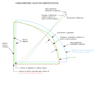
The vertical deflection (VD) or deflection of the vertical (DoV), also known as deflection of the plumb line and astro-geodetic deflection, is a measure of how far the gravity direction at a given point of interest is rotated by local mass anomalies such as nearby mountains. They are widely used in geodesy, for surveying networks and for geophysical purposes.

<span class="mw-page-title-main">Geodetic datum</span> Reference frame for measuring location

A geodetic datum or geodetic system is a global datum reference or reference frame for precisely representing the position of locations on Earth or other planetary bodies by means of geodetic coordinates. Datums are crucial to any technology or technique based on spatial location, including geodesy, navigation, surveying, geographic information systems, remote sensing, and cartography. A horizontal datum is used to measure a location across the Earth's surface, in latitude and longitude or another coordinate system; a vertical datum is used to measure the elevation or depth relative to a standard origin, such as mean sea level (MSL). Since the rise of the global positioning system (GPS), the ellipsoid and datum WGS 84 it uses has supplanted most others in many applications. The WGS 84 is intended for global use, unlike most earlier datums.

<span class="mw-page-title-main">Satellite geodesy</span> Measurement of the Earth using satellites

Satellite geodesy is geodesy by means of artificial satellites—the measurement of the form and dimensions of Earth, the location of objects on its surface and the figure of the Earth's gravity field by means of artificial satellite techniques. It belongs to the broader field of space geodesy. Traditional astronomical geodesy is not commonly considered a part of satellite geodesy, although there is considerable overlap between the techniques.

<span class="mw-page-title-main">ED50</span> Reference frame for European geodesy

ED50 is a geodetic datum which was defined after World War II for the international connection of geodetic networks.

<span class="mw-page-title-main">William Bowie (engineer)</span> American geodetic engineer

William Bowie, B.S., C.E., M.A. was an American geodetic engineer.

Karl-Rudolf Koch is a German geodesist and professor at the University of Bonn (FRG). In the global geodetic community, he is well known for his research work in geodetic statistics, particularly robust parameter estimation and in gravity field models.

<span class="mw-page-title-main">North American Vertical Datum of 1988</span> Vertical datum for orthometric heights

}} The North American Vertical Datum of 1988 is the vertical datum for orthometric heights established for vertical control surveying in the United States of America based upon the General Adjustment of the North American Datum of 1988.

<span class="mw-page-title-main">Petr Vaníček</span>

Petr Vaníček is a Czech Canadian geodesist and theoretical geophysicist who has made important breakthroughs in theory of spectrum analysis and geoid computation.

<span class="mw-page-title-main">Earth ellipsoid</span> Geometric figure which approximates the Earths shape

An Earth ellipsoid or Earth spheroid is a mathematical figure approximating the Earth's form, used as a reference frame for computations in geodesy, astronomy, and the geosciences. Various different ellipsoids have been used as approximations.

<span class="mw-page-title-main">Vertical datum</span> Reference surface for vertical positions

In geodesy, surveying, hydrography and navigation, vertical datum or altimetric datum, is a reference coordinate surface used for vertical positions, such as the elevations of Earth-bound features and altitudes of satellite orbits and in aviation. In planetary science, vertical datums are also known as zero-elevation surface or zero-level reference.

<span class="mw-page-title-main">National Spatial Reference System</span> NAD 83 & NAVD 88 based National Geodetic Coordinate System

The National Spatial Reference System (NSRS), managed by the National Geodetic Survey (NGS), is a coordinate system that includes latitude, longitude, elevation, and other values. The NSRS consists of a National Shoreline, the NOAA CORS Network, a network of permanently marked points, and a set of models that describe dynamic geophysical processes affecting spatial measurements. The system is based on NAD 83 and NAVD 88.

<span class="mw-page-title-main">South American Datum</span>

}} The South American Datum (SAD) is a regional historical geodetic datum for South America. The most common version was established in 1969 (SAD69), as adopted by the Pan American Institute of Geography and History.

William M. Kaula was an Australian-born American geophysicist and professor at the University of California, Los Angeles. Kaula was most notable for his contributions to geodesy, including using early satellites to produce maps of Earth's gravity. The National Academies Press called Kaula "the father of space-based geodesy". The Los Angeles Times called him "one of the leading planetary physicists of the last four decades".

<span class="mw-page-title-main">Army Map Service</span> Military unit

The Army Map Service (AMS) was the military cartographic agency of the United States Department of Defense from 1941 to 1968, subordinated to the United States Army Corps of Engineers. On September 1, 1968, the AMS was redesignated the U.S. Army Topographic Command (USATC) and continued as an independent organization until January 1, 1972, when it was merged into the new Defense Mapping Agency (DMA) and redesignated as the DMA Topographic Center (DMATC). On October 1, 1996, DMA was folded into the National Imagery and Mapping Agency (NIMA), which was redesignated as the National Geospatial-Intelligence Agency (NGA) in 2003.

References

  1. 1 2 Record at geni.com (includes a portrait)
  2. National Geodetic Survey (U.S.) (1986). Geodetic Glossary. NOAA technical publications. U.S. Department of Commerce, National Oceanic and Atmospheric Administration, National Ocean Service, Charting and Geodetic Services. p. 56. Retrieved 2021-07-02.
  3. Fischer, Irene (1969). "Modification of the Mercury Datum". The Military Engineer. 61 (401). Society of American Military Engineers: 191–193. ISSN   0026-3982. JSTOR   44562130 . Retrieved 2021-07-02.
  4. "Irene K. Fischer, Geodesist." By Wendy J. W. Straight. NEWSLETTER NO. 2/05, JOINT COMMISSION WORKING GROUP ON UNDER-REPRESENTED GROUPS IN SURVEYING.
  5. "Women in GEOINT: Irene K. Fischer | National Geospatial-Intelligence Agency". www.nga.mil. Retrieved 2021-07-20.
  6. "Army Announces 15 Selections for R&D Achievement Awards" Army Research & Development Newsmagazine (June 1966): 8-9. via Internet Archive
  7. Internet Archive (2022-10-19). "Geometry" . Retrieved 2023-10-15.

Further reading