Jamestown, Pennsylvania

Last updated
Jamestown, Pennsylvania
Gibson House in Jamestown.jpg
The Gibson House, a historic site in the borough
Nickname: 
Gateway to Pymatuning
Mercer County Pennsylvania Incorporated and Unincorporated areas Jamestown Highlighted.svg
Location of Jamestown in Mercer County, Pennsylvania.
USA Pennsylvania location map.svg
Red pog.svg
Jamestown, Pennsylvania
Location of Jamestown within Pennsylvania
Coordinates: 41°29′11″N80°26′18″W / 41.48639°N 80.43833°W / 41.48639; -80.43833
CountryUnited States
State Pennsylvania
County Mercer
Founded1798
Government
  MayorJustin Pipp
Area
[1]
  Total0.84 sq mi (2.17 km2)
  Land0.83 sq mi (2.16 km2)
  Water0.01 sq mi (0.01 km2)
Population
 (2020) [2]
  Total582
  Density698.68/sq mi (269.70/km2)
Time zone UTC-4 (EST)
  Summer (DST) UTC-5 (EDT)
Zip code
16134
Area code 724
School districtJamestown School District
Website www.jamestown-pa.com

Jamestown is a borough in northwestern Mercer County, Pennsylvania, United States, along the Shenango River. The population was reported as 580 on the 2020 census. [3] It is part of the Hermitage micropolitan area.

Contents

History

The town was founded in 1798 by James Campbell. The borough was incorporated in 1853.

The Jamestown area is served by the Jamestown Area School District, and is home to Combined Systems, Inc., a tactical weapons producer that exports tear gas and smoke grenades. [4]

The Gibson House was added to the National Register of Historic Places in 1978. [5]

The 215 Restaurant has become one of the more known places to dine bringing a different flair to the area that most would have to travel further for.

Pymatuning Deer Park has become quite the tourist attraction bringing a zoo like experience with a small petting zoo and interactive bird cage.

Jamestown Coating Technologies employs a large amount of locals and distributes high quality paints, powder coats and more throughout the world.

Geography

Jamestown is located at 41°29′11″N80°26′18″W / 41.48639°N 80.43833°W / 41.48639; -80.43833 (41.486417, −80.438354). [6]

According to the United States Census Bureau, the borough has a total area of 0.8 square miles (2.1 km2), of which 0.8 square miles (2.1 km2) is land and 1.27% is water.

Historical population
CensusPop.Note
1860 256
1870 572123.4%
1880 97470.3%
1890 822−15.6%
1900 8341.5%
1910 822−1.4%
1920 818−0.5%
1930 710−13.2%
1940 81915.4%
1950 93113.7%
1960 897−3.7%
1970 9374.5%
1980 854−8.9%
1990 761−10.9%
2000 636−16.4%
2010 617−3.0%
2020 580−6.0%
2021 (est.)575 [3] −0.9%
Sources: [7] [8] [9] [2]

Climate

Climate data for Jamestown, Pennsylvania (1991–2020 normals, extremes 1932–present)
MonthJanFebMarAprMayJunJulAugSepOctNovDecYear
Record high °F (°C)70
(21)
75
(24)
84
(29)
89
(32)
93
(34)
98
(37)
102
(39)
99
(37)
99
(37)
88
(31)
81
(27)
73
(23)
102
(39)
Average high °F (°C)33.7
(0.9)
36.3
(2.4)
45.2
(7.3)
59.1
(15.1)
69.5
(20.8)
77.5
(25.3)
81.1
(27.3)
79.7
(26.5)
73.6
(23.1)
61.9
(16.6)
49.5
(9.7)
38.6
(3.7)
58.8
(14.9)
Daily mean °F (°C)25.0
(−3.9)
26.4
(−3.1)
34.7
(1.5)
46.9
(8.3)
57.6
(14.2)
66.0
(18.9)
69.9
(21.1)
68.4
(20.2)
62.0
(16.7)
50.9
(10.5)
40.3
(4.6)
30.9
(−0.6)
48.2
(9.0)
Average low °F (°C)16.4
(−8.7)
16.5
(−8.6)
24.3
(−4.3)
34.7
(1.5)
45.6
(7.6)
54.4
(12.4)
58.7
(14.8)
57.1
(13.9)
50.5
(10.3)
40.0
(4.4)
31.1
(−0.5)
23.2
(−4.9)
37.7
(3.2)
Record low °F (°C)−27
(−33)
−27
(−33)
−18
(−28)
3
(−16)
21
(−6)
28
(−2)
35
(2)
32
(0)
27
(−3)
14
(−10)
−2
(−19)
−19
(−28)
−27
(−33)
Average precipitation inches (mm)3.16
(80)
2.26
(57)
3.00
(76)
3.93
(100)
3.92
(100)
4.90
(124)
4.63
(118)
3.77
(96)
4.24
(108)
3.55
(90)
3.22
(82)
3.22
(82)
43.80
(1,113)
Average snowfall inches (cm)18.6
(47)
13.3
(34)
9.5
(24)
1.6
(4.1)
0.0
(0.0)
0.0
(0.0)
0.0
(0.0)
0.0
(0.0)
0.0
(0.0)
0.1
(0.25)
5.0
(13)
13.4
(34)
61.5
(156)
Average precipitation days (≥ 0.01 in)17.113.313.014.113.612.912.511.310.613.713.815.5161.4
Average snowy days (≥ 0.1 in)10.37.64.71.00.00.00.00.00.00.12.37.633.6
Source: NOAA [10] [11]

Demographics

As of the census [8] of 2000, there were 636 people, 269 households, and 171 families residing in the borough. The population density was 819.5 inhabitants per square mile (316.4/km2). There were 297 housing units at an average density of 382.7 per square mile (147.8/km2). The racial makeup of the borough was 99.53% White, and 0.47% from two or more races.

There were 269 households, out of which 26.8% had children under the age of 18 living with them, 50.9% were married couples living together, 9.7% had a female householder with no husband present, and 36.1% were non-families. 29.7% of all households were made up of individuals, and 15.6% had someone living alone who was 65 years of age or older. The average household size was 2.36 and the average family size was 2.97.

In the borough the population was spread out, with 24.8% under the age of 18, 8.2% from 18 to 24, 27.2% from 25 to 44, 24.7% from 45 to 64, and 15.1% who were 65 years of age or older. The median age was 38 years. For every 100 females there were 87.1 males. For every 100 females age 18 and over, there were 85.3 males.

The median income for a household in the borough was $26,979, and the median income for a family was $40,000. Males had a median income of $31,875 versus $17,917 for females. The per capita income for the borough was $15,199. About 11.6% of families and 15.8% of the population were below the poverty line, including 20.3% of those under age 18 and 3.4% of those age 65 or over.

See also

Related Research Articles

<span class="mw-page-title-main">Churchill, Pennsylvania</span> Borough in Pennsylvania, United States

Churchill is a borough in Allegheny County, Pennsylvania, United States. The population was 3,157 at the 2020 census. It is a residential suburb of the Pittsburgh metropolitan area. The town was named from the hilltop Beulah Presbyterian Church.

<span class="mw-page-title-main">Haysville, Pennsylvania</span> Borough in Pennsylvania, United States

Haysville is a borough in Allegheny County, Pennsylvania, United States, along the Ohio River. The population was 81 according to the 2020 census, making it the least-populous municipality in Allegheny County.

<span class="mw-page-title-main">Sylvania, Pennsylvania</span> Borough in Pennsylvania, United States

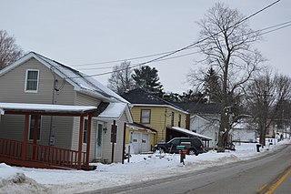
Sylvania is a borough in Bradford County, Pennsylvania, United States. It is part of Northeastern Pennsylvania. The population was 216 at the 2020 census. Children residing in the borough are assigned to attend the Troy Area School District.

<span class="mw-page-title-main">Harrisville, Pennsylvania</span> Borough in Pennsylvania, United States

Harrisville is a borough in Butler County, Pennsylvania, United States. The population was 897 at the 2010 census.

<span class="mw-page-title-main">Prospect, Pennsylvania</span> Borough in Pennsylvania, United States

Prospect is a borough in Butler County, Pennsylvania, United States. As of the 2010 census, the borough had a population of 1,169.

<span class="mw-page-title-main">West Liberty, Pennsylvania</span> Borough in Pennsylvania, United States

West Liberty is a borough in Butler County, Pennsylvania, United States. The population was 343 at the 2010 census.

<span class="mw-page-title-main">East Side, Pennsylvania</span> Borough in Pennsylvania, United States

East Side is a borough in Carbon County, Pennsylvania. It is part of Northeastern Pennsylvania. The population was 317 at the 2010 census.

<span class="mw-page-title-main">Knox, Pennsylvania</span> Borough in Pennsylvania, United States

Knox is a borough in Clarion County, Pennsylvania, United States. The population was 1,102 at the 2020 census.

<span class="mw-page-title-main">Shippenville, Pennsylvania</span> Borough in Pennsylvania, United States

Shippenville is a borough in Clarion County, Pennsylvania, United States. The population was 446 at the 2020 census.

<span class="mw-page-title-main">Blooming Valley, Pennsylvania</span> Borough in Pennsylvania, United States

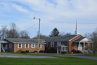
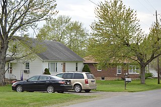
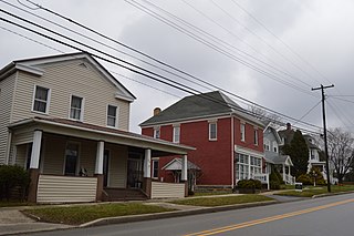
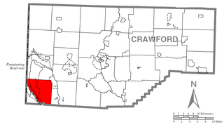
Blooming Valley is a borough in Crawford County, Pennsylvania, United States. The population was 342 at the 2020 census, up from 337 at the 2010 census.

<span class="mw-page-title-main">Conneaut Lake, Pennsylvania</span> Borough in Pennsylvania, United States

Conneaut Lake is a borough in Crawford County, Pennsylvania, located at the southern end of the lake of the same name. The population was 625 at the 2020 census, down from 653 at the 2010 census.

<span class="mw-page-title-main">Conneautville, Pennsylvania</span> Borough in Pennsylvania, United States

Conneautville is a borough in Crawford County, Pennsylvania, United States, situated along Conneaut Creek. The population was 736 at the 2020 census, down from 774 at the 2010 census.

<span class="mw-page-title-main">Pymatuning South, Pennsylvania</span> Census-designated place in Pennsylvania, United States

Pymatuning South is a census-designated place (CDP) in Crawford County, Pennsylvania, United States. The population was 479 at the 2010 census.

<span class="mw-page-title-main">South Shenango Township, Pennsylvania</span> Township in Pennsylvania, United States

South Shenango Township is a township in Crawford County, Pennsylvania, United States. The population was 1,831 at the 2020 census, down from 2,037 at the 2010 census.

<span class="mw-page-title-main">Woodcock, Pennsylvania</span> Borough in Pennsylvania, United States

Woodcock is a borough in Crawford County, Pennsylvania, United States. The population was 140 at the 2020 census, down from 157 at the 2010 census.

<span class="mw-page-title-main">McKean, Pennsylvania</span> Borough in Pennsylvania, United States

McKean is a borough in Erie County, Pennsylvania. The population was 475 at the time of the 2020 census. It is part of the Erie–Meadville combined statistical area. McKean was known as "Middleboro" until it officially changed its name in 1970.

<span class="mw-page-title-main">Corsica, Pennsylvania</span> Borough in Pennsylvania, United States

Corsica is a borough in Jefferson County, Pennsylvania, United States. The population was 357 at the 2010 census. It was named for the island of Corsica, birthplace of Napoleon Bonaparte. The mayor of the borough is Dave Leadbetter.

<span class="mw-page-title-main">New Lebanon, Pennsylvania</span> Borough in Pennsylvania, United States

New Lebanon is a borough in northeastern Mercer County, Pennsylvania, United States. The population was 186 at the 2020 census. It is part of the Hermitage micropolitan area.

<span class="mw-page-title-main">Stoneboro, Pennsylvania</span> Borough in Pennsylvania, United States

Stoneboro is a borough in eastern Mercer County, Pennsylvania, United States. The population was 946 at the 2020 census. It is part of the Hermitage micropolitan area.

<span class="mw-page-title-main">Ellwood City, Pennsylvania</span> Borough in Pennsylvania, United States

Ellwood City is a borough primarily in Lawrence County, Pennsylvania, United States. With a small district extending into Beaver County, it lies along the Connoquenessing Creek just east of its confluence with the Beaver River. The population was 7,642 at the 2020 census. Ellwood City lies 30 miles (48 km) northwest of Pittsburgh and 8 miles (13 km) southeast of New Castle within the Pittsburgh metropolitan area.

References

  1. "ArcGIS REST Services Directory". United States Census Bureau. Retrieved October 12, 2022.
  2. 1 2 "Census Population API". United States Census Bureau. Retrieved Oct 12, 2022.
  3. 1 2 Bureau, US Census. "City and Town Population Totals: 2020-2021". Census.gov. US Census Bureau. Retrieved 18 July 2022.
  4. Chatterjee, Pratap (February 4, 2011). "Egypt's Military-industrial Complex". The Guardian . Guardian News and Media Ltd. Retrieved February 5, 2011.
  5. "National Register Information System". National Register of Historic Places . National Park Service. July 9, 2010.
  6. "US Gazetteer files: 2010, 2000, and 1990". United States Census Bureau. 2011-02-12. Retrieved 2011-04-23.
  7. "Census of Population and Housing". U.S. Census Bureau. Retrieved 11 December 2013.
  8. 1 2 "U.S. Census website". United States Census Bureau . Retrieved 2008-01-31.
  9. "Incorporated Places and Minor Civil Divisions Datasets: Subcounty Resident Population Estimates: April 1, 2010 to July 1, 2012". Population Estimates. U.S. Census Bureau. Archived from the original on 11 June 2013. Retrieved 11 December 2013.
  10. "NowData – NOAA Online Weather Data". National Oceanic and Atmospheric Administration. Retrieved August 7, 2021.
  11. "Station: Jamestown 2 NW, PA". U.S. Climate Normals 2020: U.S. Monthly Climate Normals (1991-2020). National Oceanic and Atmospheric Administration. Retrieved August 7, 2021.