Perry Township, Mercer County, Pennsylvania

Last updated
Perry Township, Mercer County, Pennsylvania
Loper Road houses at Hadley.jpg
Loper Road at Hadley
Map of Perry Township, Mercer County, Pennsylvania Highlighted.PNG
Location of Perry Township in Mercer County
Map of Pennsylvania highlighting Mercer County.svg
Location of Mercer County in Pennsylvania
Country United States
State Pennsylvania
County Mercer County
Area
[1]
  Total18.01 sq mi (46.64 km2)
  Land18.00 sq mi (46.62 km2)
  Water0.01 sq mi (0.02 km2)
Population
 (2020) [2]
  Total1,332
  Estimate 
(2022) [2]
1,312
  Density77.50/sq mi (29.92/km2)
Time zone UTC-4 (EST)
  Summer (DST) UTC-5 (EDT)
Area code 724
Historical population
CensusPop.Note
2000 1,471
2010 1,453−1.2%
2020 1,332−8.3%
2022 (est.)1,312 [2] −1.5%
U.S. Decennial Census [3]

Perry Township is a township in Mercer County, Pennsylvania, United States. The population was 1,332 at the 2020 census, [4] down from 1,453 in 2010. [5]

Contents

Geography

According to the United States Census Bureau, the township has a total area of 18.0 square miles (46.7 km2), of which 18.0 square miles (46.7 km2) is land and 0.06% is water.

Demographics

As of the census [6] of 2000, there were 1,471 people, 581 households, and 435 families residing in the township. The population density was 81.6 inhabitants per square mile (31.5/km2). There were 627 housing units at an average density of 34.8 per square mile (13.4/km2). The racial makeup of the township was 99.12% White, 0.07% African American, 0.07% Native American, 0.07% Asian, 0.07% from other races, and 0.61% from two or more races. Hispanic or Latino of any race were 0.14% of the population.

There were 581 households, out of which 30.1% had children under the age of 18 living with them, 66.3% were married couples living together, 5.7% had a female householder with no husband present, and 25.1% were non-families. 22.2% of all households were made up of individuals, and 10.0% had someone living alone who was 65 years of age or older. The average household size was 2.53 and the average family size was 2.96.

In the township the population was spread out, with 24.1% under the age of 18, 5.8% from 18 to 24, 28.6% from 25 to 44, 26.2% from 45 to 64, and 15.2% who were 65 years of age or older. The median age was 40 years. For every 100 females there were 101.0 males. For every 100 females age 18 and over, there were 100.2 males.

The median income for a household in the township was $35,221, and the median income for a family was $40,192. Males had a median income of $30,843 versus $25,268 for females. The per capita income for the township was $16,482. About 5.0% of families and 7.9% of the population were below the poverty line, including 14.2% of those under age 18 and 3.8% of those age 65 or over.

Related Research Articles

Maine Prairie Township is a township in Stearns County, Minnesota, United States. The population was 1,887 at the 2010 census.

Gillford Township is a township in Wabasha County, Minnesota, United States. The population was 581 at the 2000 census. The unincorporated community of Oak Center is located in the township.

<span class="mw-page-title-main">Chauncey, Ohio</span> Village in Ohio, United States

Chauncey is a village in Athens County, Ohio, United States. The population was 959 at the 2020 census. The village is located near The Plains.

<span class="mw-page-title-main">Northgate, Ohio</span> Census-designated place in Ohio, United States

Northgate is a census-designated place (CDP) in Hamilton County, Ohio, United States. The population was 7,277 at the 2020 census.

<span class="mw-page-title-main">Cumberland Township, Adams County, Pennsylvania</span> Township in Pennsylvania, United States

Cumberland Township is a township in Adams County, Pennsylvania, United States. The population was 7,033 at the 2020 census. In 1863, the American Civil War Battle of Gettysburg took place mainly in Cumberland Township, which surrounds the borough of Gettysburg on three sides.

<span class="mw-page-title-main">Liberty Township, Bedford County, Pennsylvania</span> Township in Pennsylvania, United States

Liberty Township is a township in Bedford County, Pennsylvania, United States. The population was 1,382 at the 2020 census. Warriors Path State Park is located in the township.

<span class="mw-page-title-main">Tyrone Township, Blair County, Pennsylvania</span> Township in Pennsylvania, United States

Tyrone Township is a township in Blair County, Pennsylvania, United States. It is part of the Altoona, PA Metropolitan Statistical Area. The population was 1,882 at the 2020 census.

<span class="mw-page-title-main">Bethel Township, Fulton County, Pennsylvania</span> Township in Pennsylvania, United States

Bethel Township is a township in Fulton County, Pennsylvania, United States. The population was 1,553 at the 2020 census.

<span class="mw-page-title-main">Delaware Township, Juniata County, Pennsylvania</span> Township in Pennsylvania, United States

Delaware Township is a township in Juniata County, Pennsylvania, United States. The population was 1,615 at the 2010 census.

<span class="mw-page-title-main">Slippery Rock Township, Lawrence County, Pennsylvania</span> Township in Pennsylvania, United States

Slippery Rock Township is a township in Lawrence County, Pennsylvania, United States. As of the 2020 census, the population was 2,913, a decline from the figure of 3,283 tabulated in 2010.

<span class="mw-page-title-main">Coolspring Township, Mercer County, Pennsylvania</span> Township in Pennsylvania, United States

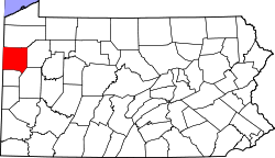
Coolspring Township is a township in Mercer County, Pennsylvania, United States. The population was 2,112 at the 2020 census, a decline from the figure of 2,278 in 2010.

<span class="mw-page-title-main">Otter Creek Township, Mercer County, Pennsylvania</span> Township in Pennsylvania, United States

Otter Creek Township is a township in Mercer County, Pennsylvania, United States. The population was 525 at the 2020 census, down from 589 in 2010. Otter Creek Township received its name due to the creek's substantial otter population.

<span class="mw-page-title-main">Old Orchard, Pennsylvania</span> Place in Pennsylvania, United States

Old Orchard is a census-designated place (CDP) in Palmer Township in Northampton County, Pennsylvania. As of the 2010 census, Old Orchard had a total population of 2,434. Old Orchard is part of the Lehigh Valley, which had a population of 861,899 and was the 68th-most populous metropolitan area in the U.S. as of the 2020 census.

<span class="mw-page-title-main">Centre Township, Perry County, Pennsylvania</span> Township in Pennsylvania, United States

Centre Township is a township in Perry County, Pennsylvania, United States. The population was 2,537 at the 2020 census.

<span class="mw-page-title-main">East Union Township, Schuylkill County, Pennsylvania</span> Township in Pennsylvania, United States

East Union Township is a township in Schuylkill County, Pennsylvania, United States. The population was 1,648 at the 2020 census.

<span class="mw-page-title-main">New Castle Township, Schuylkill County, Pennsylvania</span> Township in Pennsylvania, United States

New Castle Township is a township that is located in Schuylkill County, Pennsylvania, United States, in the state's Coal Region. The population was 348 at the time of the 2020 census.

<span class="mw-page-title-main">North Union Township, Schuylkill County, Pennsylvania</span> Township in Pennsylvania, United States

North Union Township is a township that is located in Schuylkill County, Pennsylvania, United States. The population was 1,417 at the time of the 2020 census.

<span class="mw-page-title-main">Shrewsbury Township, Sullivan County, Pennsylvania</span> Township in Pennsylvania, United States

Shrewsbury Township is a township in Sullivan County, Pennsylvania, United States. The population was 303 at the 2020 census.

<span class="mw-page-title-main">Charleston Township, Tioga County, Pennsylvania</span> Township in Pennsylvania, United States

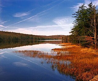
Charleston Township is a township in Tioga County, Pennsylvania, United States. The population was 3,562 at the 2020 census. Hills Creek State Park, one of 120 Pennsylvania state parks, is in Charleston Township.

<span class="mw-page-title-main">Davis, South Dakota</span> Town in South Dakota, United States

Davis is a town in Turner County, South Dakota, United States. The population was 54 at the 2020 census.

References

  1. "2016 U.S. Gazetteer Files". United States Census Bureau. Retrieved Aug 14, 2017.
  2. 1 2 3 Bureau, US Census. "City and Town Population Totals: 2020-2022". Census.gov. US Census Bureau. Retrieved June 17, 2023.
  3. "Census of Population and Housing". Census.gov. Retrieved June 4, 2016.
  4. Bureau, US Census. "City and Town Population Totals: 2020-2021". Census.gov. US Census Bureau. Retrieved 26 June 2022.
  5. "U.S. Census website". United States Census Bureau . Retrieved 2017-03-05.
  6. "U.S. Census website". United States Census Bureau . Retrieved 2008-01-31.

41°24′00″N80°15′29″W / 41.40000°N 80.25806°W / 41.40000; -80.25806