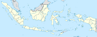
Jombang Regency is a regency of East Java, Indonesia, situated to the southwest of Surabaya. The capital of the regency is the town of Jombang. The regency has an area of 1,159.50 km2 and a population of 1,202,407 at the 2010 census and 1,318,062 at the 2020 census; the official estimate as of mid-2023 was 1,370,510. It became a regency in 1910. It was the birthplace of Abdurrahman Wahid, the 4th president of Indonesia.

Wonosobo Regency is a regency in Central Java province in Indonesia. The administrative centre of the regency is located in the town of Wonosobo, located at 7.3684940°S 109.8983841°E, about 120 km from Semarang on the Dieng Plateau. The regency's area is 984.68 km2 and its population was 754,883 at the 2010 census and 879,124 at the 2020 census; the official estimate as at mid 2023 was 909,664.

Lamongan Regency is a regency of the East Java Province of Indonesia. It has a total land area of approximately 1,812.8 km2 (699.9 sq mi) or + 3.78% of the area of East Java Province. With a length of 47 km (29 mi) along the coastline, the sea area of Lamongan Regency is about 902.4 km2 (348.4 sq mi), if calculated to a distance of 12 miles (19 km) across the ocean surface. At the 2010 census it had a population of 1,179,059; the 2020 Census produced a total of 1,379,628 and the official estimate as at mid-2023 was 1,385,835. The regency seat is the town of Lamongan, situated on the Solo River which passes from west to east through the regency, effectively dividing it in two.

Nganjuk Regency is a regency (kabupaten) of East Java Province, Indonesia. It borders Bojonegoro Regency in the north, Jombang Regency in the east, Kediri Regency in the south and Madiun Regency in the west. It covers an area of 1,224.33 sq. km, and had a population of 1,017,030 at the 2010 Census and 1,103,902 at the 2020 Census; the official estimate as of mid-2023 was 1,144,508. The administrative centre of the regency is the town of Nganjuk. The current regent is Dr. Drs. H. Marhaen Djumadi, S.E., S.H., M.M., M.B.A.
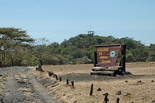
Situbondo Regency is a regency (kabupaten) in the east of East Java province, Indonesia. It covers an area of 1,658.03 km2, and had a population of 647,619 at the 2010 Census and 685,967 at the 2020 Census; the official estimate as at mid 2023 was 684,343. It is located towards the eastern end of Java, before Banyuwangi. The administrative centre is Situbondo, a small town within the regency. One of the famous tourist sites is Baluran National Park.
Sukoharjo Regency is a regency in the Central Java province in Indonesia. It covers an area of 493.23 km2 and had a population of 824,238 at the 2010 Census and 907,587 at the 2020 Census; the official estimate as of mid-2023 was 932,680. Its administrative centre is in the town of Sukoharjo, about 10 km south of Surakarta. This regency is bordered by the city of Surakarta in the north, Karanganyar Regency in the east, Wonogiri Regency and Yogyakarta in the south as well as Klaten Regency in the west. The regency is part of the metropolitan zone of Surakarta, which is known as Subosukawonosraten.
Rembang Regency is a regency on the extreme northeast coast of Central Java Province, on the island of Java in Indonesia. The regency covers an area of 1,036.70 km2 on Java, and it had a population of 591,359 at the 2010 Census and 645,333 at the 2020 Census; the official estimate as of mid-2023 was 660,166, of whom 331,870 were males and 328,296 were females. Its administrative capital is the town of Rembang.
Sragen Regency is a regency in the eastern part of Central Java province in Indonesia. It covers an area of 994.57 km2 and had a population of 858,266 at the 2010 Census and 976,951 at the 2020 Census; the official estimate as at mid 2023 was 997,485. Its capital is the town of Sragen, located about 30 km to the northeast of Surakarta. Sragen is bordered by East Java Province to the east.
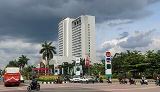
Rantauprapat is a city in North Sumatra province of Indonesia and it is the seat (capital) of Labuhan Batu Regency. Rantauprapat is also a name of village within the district of Rantau Utara. It consists of 3 main roads. A number of citizens move to larger cities like Medan in search for more job opportunities and/or universities. A large river named the Bilah River runs through the town, which had 140,778 inhabitants at the 2010 Census, 170,462 at the 2020 Census, and 177,918 according to the official estimates as at mid 2023.

Pinrang Regency is one of the twenty-one regencies in South Sulawesi Province of Indonesia. Pinrang town in Watang Sawitto District is the administrative capital of Pinrang Regency. The regency is situated in the northwest of the South Sulawesi peninsula, and covers a land area of 1,896.57 km2. It had a population of 351,161 at the 2010 Census and 403,994 at the 2020 Census; the official estimate as at mid 2023 was 417,932.
Kefamenanu is a town and capital of the administrative district (kecamatan) of Kota Kefamenanu and of the North Central Timor Regency in West Timor, Indonesia. A road connects it to Halilulik and Kota Atambua to the northeast. It had a population of 43,058 at the 2010 Census and 47,766 at the 2020 Census; the official estimate in mid 2023 was 49,589. The town hosts the University of Timor, one of the two public universities in the Indonesian part of the island.

Bantaeng Regency is a regency of South Sulawesi Province in Indonesia. It covers an area of 395.83 km2 and had a population of 176,984 at the 2010 Census, rising to 196,716 at the 2020 Census. The official estimate as at mid 2023 was 211,623. The administrative centre is the town of Bantaeng, which lies on the south coast of the southern peninsula of Sulawesi island.
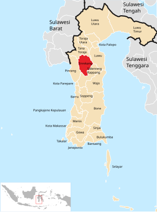
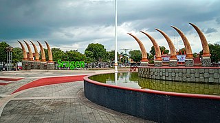
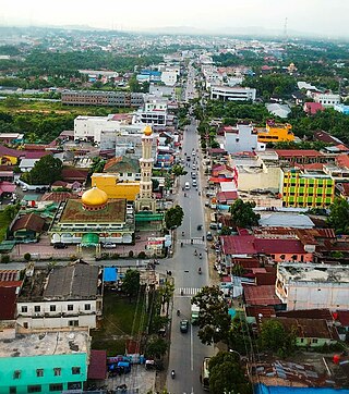
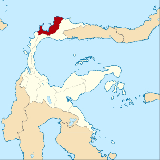
Enrekang Regency is an inland regency of South Sulawesi Province of Indonesia. It covers an area of 1,821.53 km2 and had a population of 190,175 at the 2010 census and 225,172 at the 2020 census; the official estimate as at mid 2023 was 231,301. The principal town lies at Enrekang.

North Kolaka Regency is a regency in the northwest part of Southeast Sulawesi province of Indonesia. It was created on 18 December 2003 from the former northern districts of Kolaka Regency. It covers an area of 2,932 km2, and had a population of 121,476 at the 2010 Census, and 137,700 at the 2020 Census; the official estimate as at mid 2023 was 140,488 - comprising 71,995 males and 68,493 females. The principal town lies at Lasusua.
Tolitoli Regency is a regency of Central Sulawesi Province of Indonesia. It was previously part of a larger Buol Tolitoli Regency, but this was split into two on 4 October 1999 after rapid decentralization of the Indonesian government. The present Tolitoli Regency covers an area of 3,701.54 km2 and had a population of 211,296 at the 2010 Census and 225,154 at the 2020 Census; the official estimate as at mid 2023 was 231,711, comprising 118,180 male and 113,530 female inhabitants. Its regency seat is located at the town of Tolitoli, which is a port town and where the regency's population is concentrated.

South Buru Regency is a regency of Maluku, Indonesia. It was created on 24 June 2008 by being split off from the existing Buru Regency. It is located on the island of Buru, of which it comprises the southern 40%. The Regency covers an area of 5,060 km2, and it had a population of 53,671 at the 2010 Census, rising to 75,410 at the 2020 Census; the official estimate as at mid 2023 was 79,017. The principal town lies at Elfule in Namrole District.

Taliwang is the regency seat of West Sumbawa Regency, on the western coast of the island of Sumbawa. It is the fifth largest town on the island of Sumbawa, with a population of 44,136 at the 2010 Census and 55,340 at the 2020 Census; the official estimate as at mid 2023 was 57,540.
Banggai Sea Regency is a regency in the province of Central Sulawesi, Indonesia. The regency was established on 14 December 2012, partitioned from the Banggai Islands Regency. It comprises the southern part of the Banggai Islands archipelago, including the main island of Banggai itself, the islands of Labobo and Bangkurung to the southwest of Banggai Island, and the numerous small Bokan Islands to the southeast; it does not include the larger island of Peleng to the north which forms the Banggai Islands Regency. The new Banggai Sea Regency covers a land area of 725.67 km2, and the districts now comprising the new Regency had a population of 62,183 at the 2010 Census and 70,435 at the 2020 Census; the official estimate as at mid 2023 was 73,100.

Sampang is a town, district and the regency seat of Sampang Regency, in the East Java Province of Indonesia. It is located on the south coast of Madura Island. Its population was 124,390 at the 2020 Census, and the official estimate as at mid 2023 was 130,867.
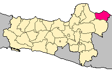
Kraksaan is a town, an administrative district and the regency seat of Probolinggo Regency, East Java, Indonesia. Its population was 65,590 at the Census of 2010 and 68,146 at the 2020 Census; the official estimate as at mid 2023 was 68,551.