Ross and Cromarty, also referred to as Ross-shire and Cromartyshire, is a variously defined area in the Highlands and Islands of Scotland. There is a registration county and a lieutenancy area in current use, the latter of which is 8,019 square kilometres in extent. Historically there has also been a constituency of the Parliament of the United Kingdom, a local government county, a district of the Highland local government region and a management area of the Highland Council. The local government county is now divided between two local government areas: the Highland area and Na h-Eileanan Siar. Ross and Cromarty border Sutherland to the north and Inverness-shire to the south.

Selkirkshire or the County of Selkirk is a historic county and registration county of Scotland. It borders Peeblesshire to the west, Midlothian to the north, Roxburghshire to the east, and Dumfriesshire to the south. It derives its name from its county town, the royal burgh of Selkirk. The county was historically also known as Ettrick Forest.
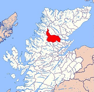
The Black Isle is a peninsula within Ross and Cromarty, in the Scottish Highlands. It includes the towns of Cromarty and Fortrose, and the villages of Culbokie, Resolis, Jemimaville, Rosemarkie, Avoch, Munlochy, Tore, and North Kessock, as well as numerous smaller settlements. About 12,000 people live on the Black Isle, depending on the definition.

Tarbat is a civil parish in Highland, Scotland, in the north-east corner of Ross and Cromarty.

Caddonfoot is a village on the River Tweed, in the Scottish Borders area of Scotland, on the A707, near Galashiels.
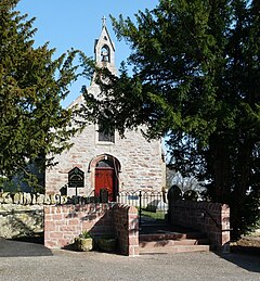
Resolis is a village and parish on the B9163 road, in the Black Isle in Scotland. It is part of the Presbytery of Ross. In 2011 it had a population of 362.

Scoonie is a settlement and parish in Fife, Scotland, the parish contains the town of Leven. It is bordered on the north by the parishes of Kettle and Ceres, on the east by the parish of Largo, on the south by the parishes of Markinch and Wemyss, and on the west by the parishes of Markinch and Kennoway. It extends about 4+1⁄2 miles north to south. Its width varies between 5⁄8 and 2+3⁄4 mi . The parish is on the coast of the Firth of Forth, with a coastline of about 1+1⁄2 mi (2.4 km) The area of the parish is 4,107 acres.

Abdie is a parish in north-west Fife, Scotland, lying on the south shore of the Firth of Tay on the eastern outskirts of Newburgh, extending about 3 miles eastwards to the boundary of Dunbog parish, with which it is now united ecclesiastically and for the Community Council. It is also bounded by Collessie on the south and has a small border with the parish of Moonzie in the south-east.
Logie is a parish and village in east Fife, Scotland, 5 miles north-east of Cupar.
Kirkcaldy and Dysart is a civil parish on the south coast of Fife, Scotland, lying on the Firth of Forth, containing the towns of Kirkcaldy and Dysart and their hinterland. The civil parish was formed in December 1901 by an amalgamation of the parishes of Kirkcaldy, Dysart and Abbotshall, along with the portion of the parish of Kinghorn which lay within the burgh of Kirkcaldy. However the parish of Abbotshall was originally part of the parish of Kirkcaldy and had only been disjoined from it in 1650.
Kincardine is a civil parish in the Scottish council area of Stirling and the former county of Perthshire in the historic district of Menteith.
Kincardine is an extensive civil parish and Community council area on the south side of the Kyle of Sutherland, within the Highland unitary authority area of Scotland, the largest settlement being Ardgay.
Kildonan is a parish in Sutherland, Scotland. It is located in the east next to the boundary with Caithness. It has a coast line of about 5 miles, but extends about 25 miles inland. Its main settlement is Helmsdale.
Eddrachillis is a civil parish in north-west Sutherland, Scotland. In Gaelic it means: between two firths. For local government, it forms part of the Highland Unitary Authority.

Lochbroom is a civil parish in Ross and Cromarty, Scotland, part of the Highland Unitary Authority area. Its name is Gaelic (Lochbraon), meaning "loch of rain showers". It completely surrounds Loch Broom, a sea loch extending from 7 miles (11 km) inland from the Minch on the west coast of Scotland. The former parish church stands at the head of this loch, hence the name of the parish. Lochbroom is also a Community council area, but the north-west corner of the parish is the Coigach community council area.

Torosay is a civil parish on the Isle of Mull in the county of Argyll, Scotland, part of the Argyll and Bute council area. It is one of three parishes on the island and extends over the central and south-eastern part. It is bordered by the parish of Kilninian and Kilmore in the north and Kilfinichen and Kilvickeon in the south-west. It extends about 12 miles east-west and 10 miles north-south. On the north-east coast it is separated from the mainland by the Sound of Mull. On its south-east coast, part of it is almost severed from the rest of the parish by the sea lochs Spelve and Buie, together with the freshwater loch Uisg, in between. This peninsula, which includes the hamlet of Croggan, is joined to the main island by a small isthmus at Kinlochspelvie and another at the settlement of Lochbuie. There is a smaller sea loch Loch Don, which gives its name to the hamlet of Lochdon. Further north, there is a bay at Craignure which is the location of a ferry port.

Lochs is a civil parish on the Isle of Lewis in the Western Isles, Scotland. It is one of the four civil parishes in Lewis and extends over the south-eastern part. It is bordered by the parish of Stornoway in the north and Uig in the west. Loch Seaforth separates it from Harris in the south, apart from a 19 miles land border with Harris. It extends about 19 miles north to south and 16 miles east-west. The Shiant Islands, about five miles (8.0 km) to the south-east, also belong to the parish. The parish is so-named because of the profusion of lochs, sea and fresh-water, in the area.

Keose is a settlement in the Kinloch community council area of the Western Isles, Scotland, in the civil parish of Lochs. It lies on the north shore of Loch Erisort. The old Parish Church, serving the parish of Lochs, was erected in 1830 on an island in Keose bay, but is now in ruins. The adjacent township of Keose Glebe was formerly the glebe of the manse of the parish church, but after 1929 it was split into crofts. Near Keose on the Swordale peninsula are ruins of what Is probably the first post-Reformation church in the parish of Lochs.
Logie Easter is a civil parish in Easter Ross in the Highland area of Scotland. It is bordered by the parishes of Edderton and Tain in the north and Fearn and Nigg in the east. The Balnagown River on the south forms the border with Kilmuir Easter. It extends about 7.5 miles from east to west.