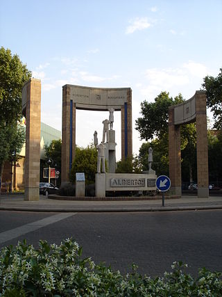
Alberton is a city situated on the southern part of the East Rand of the Gauteng Province in South Africa and is situated very close to the major urban centre of Johannesburg.
Elladoone is a suburb of Johannesburg, South Africa. It is located in Region F of the City of Johannesburg Metropolitan Municipality.
Klipriviersberg Estate is a suburb of Johannesburg, South Africa. It is located in Region 9.
Mayfield Park is a suburb of Johannesburg, South Africa. It is located in Region 9. The area code is 2091. It is home to South Downs Country Club [18 hole golf course] and the Klipriviersberg Nature Reserve. The Klip Rivier [stone river] runs through it and there is a recreation centre at the entrance to the nature reserve.
Mondeor is a suburb of Johannesburg, South Africa. It is located in Region F of the City of Johannesburg Metropolitan Municipality. Known as the Jewel of the South, Mondeor is set amongst hills outside the urban Johannesburg area but is only a 15-minute drive from the city centre.
Ophirton is a suburb of Johannesburg, South Africa. This industrial suburb lies three kilometers to south-west of the Johannesburg CBD. It is located in Region F of the City of Johannesburg Metropolitan Municipality.
Regents Park is a suburb of Johannesburg, South Africa. The suburb is found north of The Hill. It is located in Region F of the City of Johannesburg Metropolitan Municipality.
Roseacre is a suburb of Johannesburg, South Africa. It is located in Region F of the City of Johannesburg Metropolitan Municipality.
South Hills is a suburb of Johannesburg, South Africa. Also known as Suidheuwels in Afrikaans, it is about 20 minutes drive from Johannesburg Central. It is located in Region F of the City of Johannesburg Metropolitan Municipality.
Springfield is a suburb of Johannesburg, South Africa. It is a small industrial suburb located south of the Johannesburg CBD, close to La Rochelle. It is located in Region F of the City of Johannesburg Metropolitan Municipality.
The Hill is a suburb of Johannesburg, South Africa. The area lies to the south of the Johannesburg CBD and is surrounded by the suburbs of Regents Park, Rosettenville and Linmeyer. It is located in Region F of the City of Johannesburg Metropolitan Municipality.
Fellside is a suburb of Johannesburg, South Africa. It is a small suburb located north-east of the city centre with Orange Grove to its north, south and east, with Houghton Estate to its west. It is located in Region E of the City of Johannesburg Metropolitan Municipality.
Victoria is a suburb of Johannesburg, South Africa. It is located in Region E of the City of Johannesburg Metropolitan Municipality. It is a small suburb located north-east of the city centre surrounded by Norwood to its north, the Houghton Estate to its west and south, while Orange Grove lies to the east.
Judith's Paarl is a suburb of Johannesburg, South Africa. It is a small suburb found on the eastern edge of the Johannesburg central business district (CBD), tucked between the suburbs of Lorentzville and Bezuidenhout Valley, with Troyeville and Kensington to the south. It is located in Region F of the City of Johannesburg Metropolitan Municipality.
Malvern is a suburb of Johannesburg, South Africa. Situated east of the Johannesburg CBD, it lies south of Kensington and north of the industrial suburb of Denver. It is located in Region F of the City of Johannesburg Metropolitan Municipality and lies just west of Bedfordview in the City of Ekurhuleni Metropolitan Municipality.
Salisbury Claims is a suburb of Johannesburg, South Africa. It is located in Region F of the City of Johannesburg Metropolitan Municipality.

Klipriviersberg Nature Reserve is a nature reserve consisting of veld and koppies (hills) run by the Johannesburg City Parks. It is located 11 kilometres (6.8 mi) south of Johannesburg, in an area of 640 hectares. Home to many species of flora and bird life, it is also home to large and small mammals such as blesbok, zebra, wildebeest and duiker. The reserve has a number of hiking trails and archaeological sites, with the Bloubosspruit flowing through the area.
Bezuidenhout Valley is a suburb of Johannesburg, South Africa. The area lies to the east of the Johannesburg CBD and is surrounded by the suburbs of Kensington to the south and Observatory to the north. It is located in Region E of the City of Johannesburg Metropolitan Municipality. It is colloquially known as the Bez Valley.
Bassonia is a southern suburb of Johannesburg, South Africa.
Unigray is a suburb of Johannesburg, South Africa, around 6 km southeast of City Hall. It lies north of Queenshaven, east of Elladoone, and west of Electron.


