
The Province of the Transvaal, commonly referred to as the Transvaal, was a province of South Africa from 1910 until 1994, when a new constitution subdivided it following the end of apartheid. The name "Transvaal" refers to the province's geographical location to the north of the Vaal River. Its capital was Pretoria, which was also the country's executive capital.

Gauteng is one of the nine provinces of South Africa.

Benoni is a town on the East Rand, Gauteng, South Africa, some 26 kilometres (16 mi) east of Johannesburg, within the City of Ekurhuleni municipality.

Johannesburg is heavily dependent upon freeways for transport around the city due to its location 1,500 metres above sea level, far from the coast or any major bodies of water. There are 10 freeways in the Greater Johannesburg Metropolitan Area: the N1, N3, N12, N14, N17, R21, R24, R59, M1 and M2. In addition, three new freeways are planned: the G5, G9 and G14. Freeways are sometimes called highways or motorways colloquially.

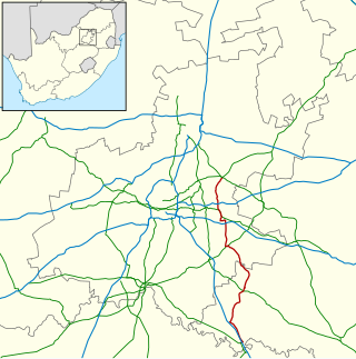
The East Rand is a major urban area located in the Gauteng province of South Africa. It is the urban eastern part of Witwatersrand that is functionally merged with the Johannesburg conurbation. The region extends from Alberton in the west to Springs in the east, and south down to Nigel. It includes the towns of Bedfordview, Benoni, Boksburg, Brakpan, Edenvale, Germiston, Kempton Park, Linksfield and Modderfontein. The East Rand is known as the transport hub of Johannesburg and includes Africa's largest and second busiest airport, OR Tambo International Airport.

Springs is a former independent city that is now part of the City of Ekurhuleni, based in the east of Johannesburg, in Gauteng Province, South Africa. It lies 50 km (31 mi) east of Johannesburg and 72 km (45 mi) southeast from Pretoria. Its name derives from the large number of springs in the area, and its estimated population is more than 121,610 in 2011. It is situated at 1628 m (5,340 ft) above sea level.

Alberton is a town situated on the southern part of the East Rand of the Gauteng Province in South Africa and is situated very close to the major urban centre of Johannesburg.

Kempton Park is a city in the East Rand region of Gauteng province, South Africa. It is part of the City of Ekurhuleni Metropolitan Municipality. It is situated south of Tembisa, one of the largest townships in South Africa, which is also part of Ekurhuleni. South Africa's busiest airport, O. R. Tambo International Airport is located in Kempton Park.

Bedfordview is an affluent suburb in western Ekurhuleni, sharing an administrative boundary with the City of Johannesburg Metropolitan Municipality, Gauteng, South Africa. Bedfordview has been part of the City of Ekurhuleni Metropolitan Municipality since 2000. The Eastgate Shopping Centre, one of the biggest in Africa when first built, is also located here.

Gautrain is an 80-kilometre (50-mile) higher-speed express commuter rail system in Gauteng, South Africa, which links Johannesburg, Pretoria, Kempton Park and O. R. Tambo International Airport. It takes 15 minutes to travel from Sandton to O. R. Tambo International Airport on the Gautrain and 35 minutes from Pretoria in Tshwane to Park Station in Johannesburg. The Gautrain has 10 stations. Buses, shuttles and midibus services are available to transport passengers to and from all stations excluding the O. R. Tambo International Airport Station.

The R29 is a provincial route in South Africa that connects Johannesburg with Leandra and Kinross via Germiston, Boksburg, Benoni and Springs. For much of its route it is named Main Reef Road. The R29 used to end near the Golela border post, however the section from Evander to Ermelo is now part of the N17 and the section from Ermelo to the Golela border post just after Pongola is now part of the N2.
The R51 is a provincial route in South Africa that connects Bapsfontein with the N3 north of Villiers, via Springs, Nigel and Balfour.

Thembisa, formerly Tembisa, is a large township situated to the north of Kempton Park on the East Rand, Gauteng, South Africa. It was established in 1957 when black people were resettled from Alexandra and other areas in Edenvale, Kempton Park, Midrand and Germiston.

Metrorail is an operator of commuter rail services in the major urban areas of South Africa. It is a division of the Passenger Rail Agency of South Africa (PRASA), a state-owned enterprise which is responsible for most passenger rail services in South Africa. The Metrorail system consists of 471 stations, 2,228 kilometres (1,384 mi) of track, and carries an average of 1.7 million passengers per weekday.

The N12 is a national route in South Africa which runs from George through Beaufort West, Kimberley, Klerksdorp and Johannesburg to eMalahleni.

Johannesburg Park Station is the central railway station in the city of Johannesburg, South Africa, and the largest railway station in Africa. It is located between the Central Business District and Braamfontein, in the block bordered by Rissik, Wolmarans, Wanderers, and Noord Streets. Park Station lies on the main Witwatersrand railway line that runs East-West from Krugersdorp to Germiston. The first four stations to the east are Doornfontein, Ellis Park, Jeppe and George Goch Stations.
Pretoria railway station is the central station in Pretoria, the executive capital of South Africa. It is located between Pretoria's central business district and Salvokop, in a 1910 building designed by Herbert Baker. It is the terminus of various Metrorail commuter rail services in the northern part of Gauteng, and a stop on Shosholoza Meyl inter-city services from Johannesburg to Polokwane and Nelspruit. Pretoria is also the northern terminus of the luxury Blue Train service from Cape Town. Platforms and tracks for the Gautrain rapid-rail service are adjacent to the main-line station.

Rand Water is a South African water utility that supplies potable water to the Gauteng province and other areas of the country and is the largest water utility in Africa. The water is drawn from numerous sources and is purified and supplied to industry, mining and local municipalities and is also involved in sanitation of waste water.


