Kuybyshevsky District, Novosibirsk Oblast

Last updated
Kuybyshevsky District
Куйбышевский район(Russian)
Kuybyshevsky rayon (Novosibirsk Oblast) location map.png
Location of Kuybyshevsky District in Novosibirsk Oblast
Coordinates: 55°27′N78°18′E / 55.450°N 78.300°E / 55.450; 78.300 Coordinates: 55°27′N78°18′E / 55.450°N 78.300°E / 55.450; 78.300
Om river Kuybyshev 2015.JPG
Flood on Om River, 2015, village Moshnino, Kuybyshevsky District
Coat of Arms of Kuibyshev (Novosibirsk oblast).png
Flag of Kuybyshev rayon (Novosibirsk oblast).png
Coat of arms
Flag
Location
Country Russia
Federal subject Novosibirsk Oblast [1]
Administrative structure (as of 2013)
Administrative center town of  Kuybyshev [1]
Inhabited localities: [1]
Rural localities 77
Municipal structure (as of July 2014)
Municipally incorporated asKuybyshevsky Municipal District [2]
Municipal divisions: [2]
Urban settlements1
Rural settlements17
Statistics
Area 8,823.3 km2 (3,406.7 sq mi) [3]
Population (2010 Census) 15,466 inhabitants [4]
 Urban0%
 Rural100%
Density 1.75/km2 (4.5/sq mi) [5]
Time zone KRAT (UTC+07:00) [6]
Official website
Kuybyshevsky District on WikiCommons

Kuybyshevsky District (Russian : Ку́йбышевский райо́н) is an administrative [1] and municipal [2] district (raion), one of the thirty in Novosibirsk Oblast, Russia. It is located in the center of the oblast. The area of the district is 8,823.3 square kilometers (3,406.7 sq mi). [3] Its administrative center is the town of Kuybyshev (which is not administratively a part of the district). [7] Population: 15,466 (2010 Census); [4] 19,386(2002 Census); [8] 21,758(1989 Census). [9]

Russian language East Slavic language

Russian is an East Slavic language, which is official in the Russian Federation, Belarus, Kazakhstan and Kyrgyzstan, as well as being widely used throughout Eastern Europe, the Baltic states, the Caucasus and Central Asia. It was the de facto language of the Soviet Union until its dissolution on 25 December 1991. Although nearly three decades have passed since the breakup of the Soviet Union, Russian is used in official capacity or in public life in all the post-Soviet nation-states, as well as in Israel and Mongolia.

A raion is a type of administrative unit of several post-Soviet states. The term is from the French "rayon", which is both a type of a subnational entity and a division of a city, and is commonly translated in English as "district".

Contents

Administrative and municipal status

Within the framework of administrative divisions, Kuybyshevsky District is one of the thirty in the oblast. [1] The town of Kuybyshev serves as its administrative center, [1] despite being incorporated separately as an administrative unit with the status equal to that of the districts. [7]

Kuybyshev, Novosibirsk Oblast Town in Novosibirsk Oblast, Russia

Kuybyshev is a town in Novosibirsk Oblast, Russia, located on the Om River, 315 kilometers (196 mi) west of Novosibirsk, the administrative center of the oblast. Population: 45,299 (2010 Census); 48,848 (2002 Census); 51,171 (1989 Census); 40,000 (1970).

City of federal subject significance is an umbrella term used to refer to a type of an administrative division of a federal subject of Russia which is equal in status to a district but is organized around a large city; occasionally with surrounding rural territories.

As a municipal division, the district is incorporated as Kuybyshevsky Municipal District, with the Town of Kuybyshev being incorporated within it as Kuybyshev Urban Settlement. [2]

Related Research Articles

Barabinsk Town in Novosibirsk Oblast, Russia

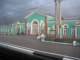
Barabinsk is a town in Novosibirsk Oblast, Russia, located in the Baraba steppe on the Trans-Siberian Railway between Omsk and Novosibirsk. Population: 30,394 (2010 Census); 32,501 (2002 Census); 36,501 (1989 Census).

Iskitim Town in Novosibirsk Oblast, Russia

Iskitim is a town in Novosibirsk Oblast, Russia, located on the Berd River. Population: 60,078 (2010 Census); 62,756 (2002 Census); 67,849 (1989 Census).

Kargat Town in Novosibirsk Oblast, Russia

Kargat is a town and the administrative center of Kargatsky District in Novosibirsk Oblast, Russia, located on the Kargat River. Population: 10,042 (2010 Census); 11,184 (2002 Census); 12,561 (1989 Census); 12,600 (1979); 12,700 (1959).

Toguchin Town in Novosibirsk Oblast, Russia

Toguchin is a town and the administrative center of Toguchinsky District in Novosibirsk Oblast, Russia, located on the Inya River 125 kilometers (78 mi) east of Novosibirsk, the administrative center of the oblast. Population: 21,900 (2010 Census); 22,179 (2002 Census); 23,189 (1989 Census).

Bolotnoye Town in Novosibirsk Oblast, Russia

Bolotnoye is a town and the administrative center of Bolotninsky District in Novosibirsk Oblast, Russia, located 126 kilometers (78 mi) northeast of Novosibirsk, the administrative center of the oblast. Population: 16,570 (2010 Census); 18,170 (2002 Census); 20,006 (1989 Census).

Cherepanovo, Novosibirsk Oblast Town in Novosibirsk Oblast, Russia

Cherepanovo is a town and the administrative center of Cherepanovsky District in Novosibirsk Oblast, Russia, located 109 kilometers (68 mi) southeast of Novosibirsk, the administrative center of the oblast. Population: 19,803 (2010 Census); 20,496 (2002 Census); 22,116 (1989 Census).

Chulym, Chulymsky District, Novosibirsk Oblast Town in Novosibirsk Oblast, Russia

Chulym is a town and the administrative center of Chulymsky District in Novosibirsk Oblast, Russia, located on the Chulym River 131 kilometers (81 mi) of Novosibirsk, the administrative center of the oblast. Population: 11,568 (2010 Census); 12,275 (2002 Census); 13,703 (1989 Census). It was previously known as Chulymskoye.

Karasuk, Novosibirsk Oblast Town in Novosibirsk Oblast, Russia

Karasuk is a town and the administrative center of Karasuksky District in Novosibirsk Oblast, Russia, located on the Karasuk River 678 kilometers (421 mi) west of Novosibirsk, the administrative center of the oblast. Population: 28,586 (2010 Census); 28,734 (2002 Census); 29,401 (1989 Census).

Kupino, Novosibirsk Oblast Town in Novosibirsk Oblast, Russia

Kupino is a town and the administrative center of Kupinsky District in Novosibirsk Oblast, Russia, located 581 kilometers (361 mi) west of Novosibirsk, the administrative center of the oblast. Population: 14,893 (2010 Census); 16,878 (2002 Census); 19,518 (1989 Census).

Barabinsky District District in Novosibirsk Oblast, Russia

Barabinsky District is an administrative and municipal district (raion), one of the thirty in Novosibirsk Oblast, Russia. It is located in the western central part of the oblast. The area of the district is 5,400 square kilometers (2,100 sq mi). Its administrative center is the town of Barabinsk. Population: 14,169 ; 17,126 (2002 Census); 18,279 (1989 Census).

Iskitimsky District District in Novosibirsk Oblast, Russia

Iskitimsky District is an administrative and municipal district (raion), one of the thirty in Novosibirsk Oblast, Russia. It is located in the east of the oblast. The area of the district is 4,384 square kilometers (1,693 sq mi). Its administrative center is the town of Iskitim. Population: 62,816 ; 66,420 (2002 Census); 67,733 (1989 Census).

Krasnozyorsky District District in Novosibirsk Oblast, Russia

Krasnozyorsky District is an administrative and municipal district (raion), one of the thirty in Novosibirsk Oblast, Russia. It is located in the south of the oblast. The area of the district is 5,330 square kilometers (2,060 sq mi). Its administrative center is the urban locality of Krasnozyorskoye. Population: 32,491 ; 38,836 (2002 Census); 40,312 (1989 Census). The population of Krasnozyorskoye accounts for 29.3% of the district's total population.

Novosibirsky District District in Novosibirsk Oblast, Russia

Novosibirsky District is an administrative and municipal district (raion), one of the thirty in Novosibirsk Oblast, Russia. It is located in the east of the oblast. The area of the district is 2,900 square kilometers (1,100 sq mi). Its administrative center is the city of Novosibirsk. Population: 127,891 ; 113,047 (2002 Census); 130,300 (1989 Census).

Suzunsky District District in Novosibirsk Oblast, Russia

Suzunsky District is an administrative and municipal district (raion), one of the thirty in Novosibirsk Oblast, Russia. It is located in the southeast of the oblast. The area of the district is 4,746 square kilometers (1,832 sq mi). Its administrative center is the urban locality of Suzun. Population: 32,592 ; 34,917 (2002 Census); 35,677 (1989 Census). The population of Suzun accounts for 47.1% of the district's total population.

Tatarsky District District in Novosibirsk Oblast, Russia

Tatarsky District is an administrative and municipal district (raion), one of the thirty in Novosibirsk Oblast, Russia. It is located in the west of the oblast. The area of the district is 4,870 square kilometers (1,880 sq mi). Its administrative center is the town of Tatarsk. Population: 15,875 ; 19,297 (2002 Census); 20,718 (1989 Census).

Toguchinsky District District in Novosibirsk Oblast, Russia

Toguchinsky District is an administrative and municipal district (raion), one of the thirty in Novosibirsk Oblast, Russia. It is located in the east of the oblast. The area of the district is 3,925 square kilometers (1,515 sq mi). Its administrative center is the town of Toguchin. Population: 60,303 ; 65,515 (2002 Census); 66,912 (1989 Census). The population of Toguchin accounts for 36.3% of the district's total population.

Ust-Tarksky District District in Novosibirsk Oblast, Russia

Ust-Tarksky District is an administrative and municipal district (raion), one of the thirty in Novosibirsk Oblast, Russia. It is located in the west of the oblast. The area of the district is 4,061 square kilometers (1,568 sq mi). Its administrative center is the rural locality of Ust-Tarka. Population: 12,307 ; 14,670 (2002 Census); 15,405 (1989 Census). The population of Ust-Tarka accounts for 31.0% of the district's total population.

Vengerovsky District is an administrative and municipal district (raion), one of the thirty in Novosibirsk Oblast, Russia. It is located in the west of the oblast. The area of the district is 6,382.71 square kilometers (2,464.38 sq mi). Its administrative center is the rural locality of Vengerovo. As of the 2010 Census, the total population of the district was 20,446, with the population of Vengerovo accounting for 34.4% of that number.

Tatarsk, Novosibirsk Oblast Town in Novosibirsk Oblast, Russia

Tatarsk is a town in Novosibirsk Oblast, Russia, located 457 kilometers (284 mi) west of Novosibirsk, the administrative center of the oblast. Population: 24,217 (2010 Census); 26,051 (2002 Census); 30,355 (1989 Census); 31,000 (1974).

References

Notes

  1. 1 2 3 4 5 6 Государственный комитет Российской Федерации по статистике. Комитет Российской Федерации по стандартизации, метрологии и сертификации. №ОК 019-95 1 января 1997 г. «Общероссийский классификатор объектов административно-территориального деления. Код 50 230», в ред. изменения №278/2015 от 1 января 2016 г.. (State Statistics Committee of the Russian Federation. Committee of the Russian Federation on Standardization, Metrology, and Certification. #OK 019-95 January 1, 1997 Russian Classification of Objects of Administrative Division . Code 50 230, as amended by the Amendment #278/2015 of January 1, 2016. ).
  2. 1 2 3 4 Law #200-OZ
  3. 1 2 "General Information" (in Russian). Kuybyshevsky District. Retrieved April 12, 2018.
  4. 1 2 Russian Federal State Statistics Service (2011). "Всероссийская перепись населения 2010 года. Том 1" [2010 All-Russian Population Census, vol. 1]. Всероссийская перепись населения 2010 года (2010 All-Russia Population Census) (in Russian). Federal State Statistics Service . Retrieved June 29, 2012.
  5. The value of density was calculated automatically by dividing the 2010 Census population by the area specified in the infobox. Please note that this value is only approximate as the area specified in the infobox does not necessarily correspond to the area of the entity proper or is reported for the same year as the population.
  6. Правительство Российской Федерации. Федеральный закон №107-ФЗ от 3 июня 2011 г. «Об исчислении времени», в ред. Федерального закона №271-ФЗ от 03 июля 2016 г. «О внесении изменений в Федеральный закон "Об исчислении времени"». Вступил в силу по истечении шестидесяти дней после дня официального опубликования (6 августа 2011 г.). Опубликован: "Российская газета", №120, 6 июня 2011 г. (Government of the Russian Federation. Federal Law #107-FZ of June 31, 2011 On Calculating Time , as amended by the Federal Law #271-FZ of July 03, 2016 On Amending Federal Law "On Calculating Time". Effective as of after sixty days following the day of the official publication.).
  7. 1 2 Государственный комитет Российской Федерации по статистике. Комитет Российской Федерации по стандартизации, метрологии и сертификации. №ОК 019-95 1 января 1997 г. «Общероссийский классификатор объектов административно-территориального деления. Код 50 415», в ред. изменения №278/2015 от 1 января 2016 г.. (State Statistics Committee of the Russian Federation. Committee of the Russian Federation on Standardization, Metrology, and Certification. #OK 019-95 January 1, 1997 Russian Classification of Objects of Administrative Division . Code 50 415, as amended by the Amendment #278/2015 of January 1, 2016. ).
  8. Russian Federal State Statistics Service (May 21, 2004). "Численность населения России, субъектов Российской Федерации в составе федеральных округов, районов, городских поселений, сельских населённых пунктов – районных центров и сельских населённых пунктов с населением 3 тысячи и более человек" [Population of Russia, Its Federal Districts, Federal Subjects, Districts, Urban Localities, Rural Localities—Administrative Centers, and Rural Localities with Population of Over 3,000](XLS). Всероссийская перепись населения 2002 года [All-Russia Population Census of 2002] (in Russian). Retrieved August 9, 2014.
  9. Demoscope Weekly (1989). "Всесоюзная перепись населения 1989 г. Численность наличного населения союзных и автономных республик, автономных областей и округов, краёв, областей, районов, городских поселений и сёл-райцентров" [All Union Population Census of 1989: Present Population of Union and Autonomous Republics, Autonomous Oblasts and Okrugs, Krais, Oblasts, Districts, Urban Settlements, and Villages Serving as District Administrative Centers]. Всесоюзная перепись населения 1989 года [All-Union Population Census of 1989] (in Russian). Институт демографии Национального исследовательского университета: Высшая школа экономики [Institute of Demography at the National Research University: Higher School of Economics]. Retrieved August 9, 2014.

Sources