The Cree are a North American Indigenous people. They live primarily in Canada, where they form one of the country's largest First Nations.

Labrador is a geographic and cultural region within the Canadian province of Newfoundland and Labrador. It is the primarily continental portion of the province and constitutes 71% of the province's area but is home to only 6% of its population. It is separated from the island of Newfoundland by the Strait of Belle Isle. It is the largest and northernmost geographical region in the four Atlantic provinces.

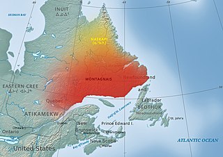
The Innu / Ilnu or Innut / Innuat / Ilnuatsh ("people"), formerly called Montagnais from the French colonial period, are the Indigenous inhabitants of territory in the northeastern portion of the present-day province of Labrador and some portions of Quebec. They refer to their traditional homeland as Nitassinan or Innu-assi.
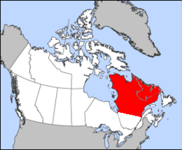
Nitassinan is the ancestral homeland of the Innu, an indigenous people of Eastern Quebec and Labrador, Canada. Nitassinan means "our land" in the Innu language. The territory covers the eastern portion of the Labrador peninsula.
The Naskapi are an Indigenous people of the Subarctic native to the historical country St'aschinuw, which is located in northern Quebec and Labrador, neighbouring Nunavik. They are closely related to Innu Nation, who call their homeland Nitassinan.

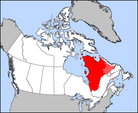
Nord-du-Québec is the largest, but the least populous, of the seventeen administrative regions of Quebec, Canada. With nearly 750,000 square kilometres (290,000 sq mi) of land area, and very extensive lakes and rivers, it covers much of the Labrador Peninsula and about 55% of the total land surface area of Quebec, while containing a little more than 0.5% of the population.

Located in the eastern part of Canada, and part of Central Canada, Quebec occupies a territory nearly three times the size of France or Texas. It is much closer to the size of Alaska. As is the case with Alaska, most of the land in Quebec is very sparsely populated. Its topography is very different from one region to another due to the varying composition of the ground, the climate, and the proximity to water. The Great Lakes–St. Lawrence Lowlands and the Appalachians are the two main topographic regions in southern Quebec, while the Canadian Shield occupies most of central and northern Quebec.

The Ungava Peninsula, officially Péninsule d'Ungava, is the far northwestern part of the Labrador Peninsula of the province of Quebec, Canada. Bounded by Hudson Bay to the west, Hudson Strait to the north, and Ungava Bay to the east, it covers about 252,000 km2 (97,000 sq mi). Its northernmost point is Cape Wolstenholme, which is also the northernmost point of Quebec. The peninsula is also part of the Canadian Shield, and consists entirely of treeless tundra dissected by large numbers of rivers and glacial lakes, flowing generally east–west in a parallel fashion. The peninsula was not deglaciated until 6,500 years ago and is believed to have been the prehistoric centre from which the vast Laurentide Ice Sheet spread over most of North America during the last glacial epoch.

The Torngat Mountains are a mountain range on the Labrador Peninsula at the northern tip of Newfoundland and Labrador and eastern Quebec. They are part of the Arctic Cordillera. The mountains form a peninsula that separates Ungava Bay from the Atlantic Ocean.

Côte-Nord is a region of 247,655.33 square kilometres (95,620.26 sq mi), the second-largest administrative region in Québec Province, Canada, behind Nord-du-Québec. It covers much of the northern shore of the Saint Lawrence River estuary and the Gulf of Saint Lawrence past Tadoussac.

The Quebec Boundaries Extension Act, 1912 was passed by the Parliament of Canada on April 1, 1912. It expanded the territory of the Province of Quebec, extending the northern boundary to its present location. The act transferred to the province all of the Northwest Territories' former District of Ungava except offshore islands. This is a vast area bounded by the Eastmain River, the Labrador coast, and Hudson and Ungava Bays. It was first claimed by England in 1670 as Rupert's Land by royal decree, becoming part of Canada after Confederation. The indigenous people of the region are Cree, Montagnais, Naskapi, and Inuit.
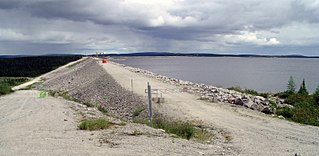
The Caniapiscau Reservoir is a reservoir on the upper Caniapiscau River in the Côte-Nord administrative region of the Canadian province of Quebec. It is the largest body of water in Quebec and the second largest reservoir in Canada.
The District of Ungava was a regional administrative district of Canada's Northwest Territories from 1895 to 1920, although it effectively ceased operation in 1912. It covered the northern portion of what is today Quebec, the interior of Labrador, and the offshore islands to the west and north of Quebec, which are now part of Nunavut.
The Mushuau Innu First Nation is a First Nations band government located in the province of Newfoundland and Labrador, Canada. The band has one reserve which has been located near the community of Natuashish since 2002 when it moved from Davis Inlet. The reserve has an area of roughly 44 square kilometres.
Innu-aimun or Montagnais is an Algonquian language spoken by over 10,000 Innu in Labrador and Quebec in Eastern Canada. It is a member of the Cree–Montagnais–Naskapi dialect continuum and is spoken in various dialects depending on the community.

The migratory woodland caribou refers to two herds of Rangifer tarandus that are included in the migratory woodland ecotype of the subspecies Rangifer tarandus caribou or woodland caribou that live in Nunavik, Quebec, and Labrador: the Leaf River caribou herd (LRCH) and the George River caribou herd (GRCH) south of Ungava Bay. Rangifer tarandus caribou is further divided into three ecotypes: the migratory barren-ground ecotype, the mountain ecotype or woodland (montane) and the forest-dwelling ecotype. According to researchers, the "George River herd which morphologically and genetically belong to the woodland caribou subspecies, at one time represented the largest caribou herd in the world and migrating thousands of kilometers from boreal forest to open tundra, where most females calve within a three-week period. This behaviour is more like barren-ground caribou subspecies." They argued that "understanding ecotype in relation to existing ecological constraints and releases may be more important than the taxonomic relationships between populations." The migratory George River caribou herd travel thousands of kilometres moving from wintering grounds to calving grounds near the Inuit hamlet of Kangiqsualujjuaq, Nunavik. In Nunavik and Labrador, the caribou population varies considerably with their numbers peaking in the later decades of each of the 18th, 19th and 20th centuries. In 1984, about 10,000 caribou of the George River herd drowned during their bi-annual crossing of the Caniapiscau River during the James Bay Hydro Project flooding operation. The most recent decline at the turn of the 20th century caused much hardship for the Inuit and Cree communities of Nunavik, who hunt them for subsistence.
Naskapi is an Algonquian language spoken by the Naskapi in Quebec and Labrador, Canada. It is written in Eastern Cree syllabics.

George River, formerly the East or George's River, is a river in northeastern Quebec, Canada, that flows from Lake Jannière mainly north to Ungava Bay.
The Little Mécatina River is a major river in the Côte-Nord region of the provinces of Labrador and Quebec, Canada. Studies have been made to exploit the hydroelectric potential of the river, which could be around 1,200 MW from three dams. The Little Mécatina River was driven first with kayaks by Rolf Theiß and Fritz Gottensrtöter from Guetersloh, Germany.
The Assembly of First Nations Quebec-Labrador is a political organization representing the First Nations of Quebec and Labrador. It represents these First Nations to the Secrétariat aux affaires autochtones du Québec and to the ministry of Crown-Indigenous Relations and Northern Affairs of Canada. The AFNQL is composed of representatives from 43 communities in the Abenaki, Algonquin, Atikamekw, Cree, Maliseet, Mi'kmaq, Innu, Huron-Wendat and Naskapi nations, as well as from the Mohawks. The AFNQL does not represent the Inuit or any Inuit community; they are represented by Inuit Tapiriit Kanatami.