Lakeview, New York

Last updated

Lakeview, New York
Langdon Blvd, Lakeview, NY August 8, 2022.jpg
Langdon Boulevard in Lakeview on August 8, 2022.
Nassau County New York incorporated and unincorporated areas Lakeview highlighted.svg
Location in Nassau County and the state of New York
Location map Long Island.png
Red pog.svg
Lakeview, New York
Location within the state of New York
USA New York location map.svg
Red pog.svg
Lakeview, New York
Lakeview, New York (New York)
Usa edcp location map.svg
Red pog.svg
Lakeview, New York
Lakeview, New York (the United States)
Coordinates: 40°40′30″N73°39′16″W / 40.67500°N 73.65444°W / 40.67500; -73.65444
Country Flag of the United States.svg  United States
State Flag of New York.svg  New York
County Flag of Nassau County, New York.svg  Nassau County, New York
Town Hempstead
Named for Its proximity to Hempstead Lake
Area
[1]
  Total1.20 sq mi (3.10 km2)
  Land1.00 sq mi (2.59 km2)
  Water0.20 sq mi (0.51 km2)
Elevation
39 ft (12 m)
Population
 (2020)
  Total6,077
  Density6,070.93/sq mi (2,344.56/km2)
Time zone UTC-5 (Eastern (EST))
  Summer (DST) UTC-4 (EDT)
ZIP codes
11552, 11570
Area code 516
FIPS code 36-41003
GNIS feature ID0954975

Lakeview is a hamlet and census-designated place (CDP) in the Town of Hempstead in Nassau County, on Long Island, in New York, United States. The population was 6,077 at the 2020 census. [2]

Contents

History

Lakeview's name reflects upon its proximity to Hempstead Lake at Hempstead Lake State Park. [3]

Geography

U.S. Census map of Lakeview. Lakeview-ny-map.gif
U.S. Census map of Lakeview.

According to the United States Census Bureau, the CDP has a total area of 1.2 square miles (3.1 km2), of which 1.0 square mile (2.6 km2) is land and 0.2 square miles (0.52 km2) (17.95%) is water. [4]

Demographics

Historical population
CensusPop.Note
2000 5,607
2010 5,6150.1%
2020 6,0778.2%
U.S. Decennial Census [5]
2010 [6] 2020 [7]

2020 census

Lakeview CDP, New York – Racial and ethnic composition
Note: the US Census treats Hispanic/Latino as an ethnic category. This table excludes Latinos from the racial categories and assigns them to a separate category. Hispanics/Latinos may be of any race.
Race / Ethnicity (NH = Non-Hispanic)Pop 2000 [8] Pop 2010 [6] Pop 2020 [7] % 2000% 2010% 2020
White alone (NH)2901281525.17%2.28%2.50%
Black or African American alone (NH)4,6744,3994,24983.36%78.34%69.92%
Native American or Alaska Native alone (NH)1330170.23%0.53%0.28%
Asian alone (NH)27441570.48%0.78%2.58%
Pacific Islander alone (NH)0100.00%0.02%0.00%
Some Other Race alone (NH)41201260.73%0.36%2.07%
Mixed Race or Multi-Racial (NH)1731402533.09%2.49%4.16%
Hispanic or Latino (any race)3898531,1236.94%15.19%18.48%
Total5,6075,6156,077100.00%100.00%100.00%

2000 Census

At the 2000 census there were 5,607 people, 1,525 households, and 1,287 families in the CDP. The population density was 5,850.2 inhabitants per square mile (2,258.8/km2). There were 1,569 housing units at an average density of 1,637.1 per square mile (632.1/km2). The racial makeup of the CDP was 6.90% White, 84.95% African American, 0.32% Native American, 0.48% Asian, 3.44% from other races, and 3.91% from two or more races. Hispanic or Latino of any race were 6.94%. [9]

Of the 1,525 households 37.8% had children under the age of 18 living with them, 51.6% were married couples living together, 26.5% had a female householder with no husband present, and 15.6% were non-families. 11.3% of households were one person and 5.5% were one person aged 65 or older. The average household size was 3.59 and the average family size was 3.81.

The age distribution was 28.3% under the age of 18, 8.1% from 18 to 24, 27.5% from 25 to 44, 22.6% from 45 to 64, and 13.5% 65 or older. The median age was 36 years. For every 100 females, there were 82.6 males. For every 100 females age 18 and over, there were 75.6 males.

The median household income was $98,036. The per capita income for the CDP was $28,575. About 4.9% of families and 6.3% of the population were below the poverty line, including 6.4% of those under age 18 and 7.7% of those age 65 or over. [10]

Related Research Articles

<span class="mw-page-title-main">Lakeview, Arkansas</span> Place in Arkansas, United States

Lakeview is a city in Baxter County, Arkansas, United States. The population was 741 at the 2010 census.

<span class="mw-page-title-main">West Rancho Dominguez, California</span> Unincorporated community in California, United States

West Rancho Dominguez, formerly known as West Compton and also known as East Gardena, is an unincorporated census-designated place (CDP) located in southern Los Angeles County, California. Per the 2020 census, the population was 24,347. The community lies to the west of the city of Compton. The ZIP Codes encompassing the CDP area are 90220 & 90248.

<span class="mw-page-title-main">Coral Terrace, Florida</span> Census-designated place in Florida

Coral Terrace is a suburban unincorporated community and census-designated place (CDP) in Miami-Dade County, Florida, United States. It is part of the Miami metropolitan area of South Florida. The population was 23,142 at the 2020 census, down from 24,376 in 2010.

<span class="mw-page-title-main">Homestead Base, Florida</span> Census-designated place in Florida

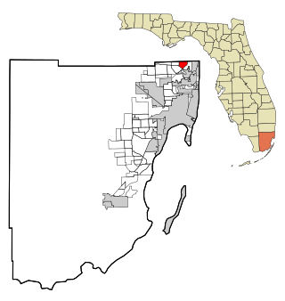
Homestead Base is a census-designated place (CDP) in Miami-Dade County, Florida, United States. The CDP comprises the extent of Homestead Air Reserve Base plus some surrounding land. It is part of the Miami metropolitan area of South Florida. The population was 999 at the 2020 census.

<span class="mw-page-title-main">Ives Estates, Florida</span> Census-designated place in Florida

Ives Estates is a census-designated place (CDP) in Miami-Dade County, Florida. It is part of the Miami metropolitan area of South Florida. The population was 25,005 at the 2020 census, up from 19,525 in 2010.

<span class="mw-page-title-main">Leisure City, Florida</span> Census-designated place in Florida

Leisure City is an unincorporated community and census-designated place (CDP) in Miami-Dade County, Florida, United States, that includes the smaller, older community of Modello in its northwestern section. The CDP is most notable for the Coral Castle Museum, located in the Modello area. It is located in the Miami metropolitan area of South Florida. The population was 26,324 at the 2020 census, up from 22,655 in 2010.

<span class="mw-page-title-main">Palmetto Estates, Florida</span> Census-designated place in Florida

Palmetto Estates is an unincorporated area and census-designated place (CDP) in Miami-Dade County, Florida, United States. It is part of the Miami metropolitan area of South Florida. The population was 13,498 at the 2020 census.

<span class="mw-page-title-main">Westview, Florida</span> Census-designated place in Florida

Westview is a census-designated place (CDP) in Miami-Dade County, Florida, United States. It is part of the Miami metropolitan area of South Florida. The population was 9,923 at the 2020 census.

<span class="mw-page-title-main">Lakeview, Georgia</span> Place in Georgia, United States

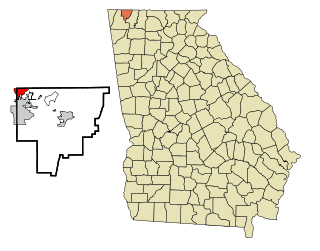
Lakeview is an unincorporated community and census-designated place (CDP) in Catoosa and Walker counties in the U.S. state of Georgia. The population was 4,820 at the 2000 census and 4,777 at the 2020 census. It is part of the Chattanooga, TN–GA Metropolitan Statistical Area.

<span class="mw-page-title-main">Channel Lake, Illinois</span> Census-designated place in Illinois, United States

Channel Lake is an unincorporated community and census-designated place (CDP) in Antioch Township, Lake County, Illinois, United States. Per the 2020 census, the population was 1,581.

Venetian Village is a census-designated place (CDP) in Lake County, Illinois, United States. Per the 2020 census, the population was 2,761.

<span class="mw-page-title-main">Frankfort Square, Illinois</span> Census-designated place in Illinois, United States

Frankfort Square is a census-designated place (CDP) in Will County, Illinois, United States. Per the 2020 census, the population was 8,968.

North Vacherie is a census-designated place (CDP) in St. James Parish, Louisiana, United States. The population was 2,411 at the 2000 census. Vacherie was noted in the 2000 census as being the town with the least mobility of all in the United States.

<span class="mw-page-title-main">Castle Point, Missouri</span> Place in Missouri, United States

Castle Point is an unincorporated community and census-designated place (CDP) in St. Louis County, Missouri, United States. The population was 3,962 at the 2010 census.

St. Bonaventure is a hamlet and census-designated place (CDP) in the town of Allegany in Cattaraugus County, New York, United States. The population was 1,963 at the 2020 census.

<span class="mw-page-title-main">Bellerose Terrace, New York</span> Hamlet and census-designated place in New York, United States

Bellerose Terrace is a hamlet and census-designated place (CDP) in the Town of Hempstead in Nassau County, on Long Island, in New York, United States. The population was 2,329 at the 2020 census.

<span class="mw-page-title-main">Roosevelt, New York</span> Hamlet and census-designated place in New York, United States

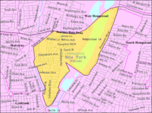
Roosevelt is a hamlet and census-designated place (CDP) in the Town of Hempstead in Nassau County, on the South Shore of Long Island, in New York, United States. The population was 18,066 at the 2020 census.

<span class="mw-page-title-main">Uniondale, New York</span> Hamlet and census-designated place in New York, United States

Uniondale is a hamlet and census-designated place in Nassau County, New York, on Long Island, in the town of Hempstead. The population was 32,473 at the time of the 2020 census. Uniondale is home to Hofstra University's north campus, as well as a portion of its southern campus.

<span class="mw-page-title-main">Hillcrest, Rockland County, New York</span> Census-designated place in New York, United States

Hillcrest is a hamlet incorporated in 1893 and census-designated place, in the town of Ramapo, Rockland County, New York, United States. It is located north of Spring Valley, east of Viola, south of New Square and New Hempstead, and west of New City. The population was 8,164 at the 2020 census.

<span class="mw-page-title-main">Fairview, Westchester County, New York</span> CDP in New York, United States

Fairview is a hamlet and a census-designated place (CDP) located in the town of Greenburgh, Westchester County, New York, United States. The population was 3,099 at the 2010 census. As of 2000, Fairview had the fourth-highest percentage of African-Americans in New York.

References

  1. "ArcGIS REST Services Directory". United States Census Bureau. Retrieved September 20, 2022.
  2. "Lakeview CDP, New York". United States Census Bureau . Retrieved February 23, 2021.
  3. Winsche, Richard (October 1, 1999). The History of Nassau County Community Place-Names. Interlaken, New York: Empire State Books. ISBN   978-1557871541.
  4. "US Gazetteer files: 2010, 2000, and 1990". United States Census Bureau. February 12, 2011. Retrieved April 23, 2011.
  5. "Decennial Census of Population and Housing by Decades". US Census Bureau.
  6. 1 2 "P2 Hispanic or Latino, and Not Hispanic or Latino by Race – 2010: DEC Redistricting Data (PL 94-171) – Lakeview CDP, New York". United States Census Bureau .
  7. 1 2 "P2 Hispanic or Latino, and Not Hispanic or Latino by Race – 2020: DEC Redistricting Data (PL 94-171) – Lakeview CDP, New York". United States Census Bureau .
  8. "P004: Hispanic or Latino, and Not Hispanic or Latino by Race – 2000: DEC Summary File 1 – Lakeview CDP, New York". United States Census Bureau.
  9. "U.S. Census website". United States Census Bureau . Retrieved January 31, 2008.
  10. "Geographic Names Information System". United States Geological Survey . Retrieved January 31, 2008.