Lamandau River

Last updated

Lamandau River
Sungai Lamandau, Sungai Kotawaringin
Indonesia Kalimantan location map.svg
Red pog.svg
River mouth location
Indonesia relief location map.jpg
Red pog.svg
Lamandau River (Indonesia)
Location
CountryIndonesia
Physical characteristics
Source 
  location Kalimantan
Mouth  
  location
Java Sea
Length300 km (190 mi)

Lamandau River (Indonesian : Sungai Lamandau) is a river of Kalimantan, southern-central Borneo, Indonesia. [1] [2] Downstream after passing the village of Nanga Bulik it becomes the Kotawaringin River. [3]

Contents

The ancient town of Kotawaringin is located in the valley formed by the river and its tributary along with gold and gemstone mining areas. In the upper reaches of the tributary valley of Arut River the Pangkalan Bun town flourishes on its banks.

Hydrology

Lamandau River flows through southern Central Kalimantan and Pangkalan Bun, discharging into the Java Sea near Kumai at 2°51′20″S111°43′14″E / 2.85556°S 111.72056°E / -2.85556; 111.72056 . It is a major tributary of the Kotawaringin River, known by this name after its confluence below Naga Bulik village. Tributaries include the Arut River, where in its upper reaches the Pangkalan Bun town is located. While the lower reaches of the river are densely populated, the upper reaches have contiguous forest areas where Orangutans can be seen. [3] Kotawaringin town to the west of the Lamandau River was the ancient capital of a Sultanate. [4]

The catchment of the Lamandau River comprises the western district of Central Kalimantan and West-Kotawaringin. West Kotawaringin district has a population of 200,000 people constituted by Tuman Dayaks (about 33%) who are Christians. The capital of this district is Pangkalan Bun, which has a sub-district, a traditional area of the Dolang, close to the Kundangan city where 7000 Dayaks reside in about 100 longhouses spread over 19 villages. [5]

Pangkalan Bun town is a waterfront town, which has a plywood manufacturing plant. Its fame is due to the mines nearby where gold and amethyst stones are extracted. In support of these mining activities, several shops selling diesel sets for use in mining have been set up. Another spin-off from the mines is the establishment of several gem stores in the town. The particularly popular item of sale is the five-set lucky stones of dark coloured amethysts, duly polished and made to shimmer for sale. [6]

Geography

Lamandau River
Climate chart (explanation)
J
F
M
A
M
J
J
A
S
O
N
D
 
 
198
 
 
24
21
 
 
270
 
 
26
21
 
 
305
 
 
24
23
 
 
339
 
 
25
22
 
 
282
 
 
26
23
 
 
207
 
 
25
22
 
 
118
 
 
25
21
 
 
132
 
 
26
21
 
 
66
 
 
26
22
 
 
147
 
 
27
22
 
 
386
 
 
24
22
 
 
329
 
 
24
21
Average max. and min. temperatures in °C
Precipitation totals in mm
Source: [7]
Imperial conversion
JFMAMJJASOND
 
 
7.8
 
 
75
70
 
 
11
 
 
79
70
 
 
12
 
 
75
73
 
 
13
 
 
77
72
 
 
11
 
 
79
73
 
 
8.1
 
 
77
72
 
 
4.6
 
 
77
70
 
 
5.2
 
 
79
70
 
 
2.6
 
 
79
72
 
 
5.8
 
 
81
72
 
 
15
 
 
75
72
 
 
13
 
 
75
70
Average max. and min. temperatures in °F
Precipitation totals in inches

The river flows in the mid-southern area of Borneo island with a predominantly tropical rainforest climate (designated as Af in the Köppen-Geiger climate classification). [8] The annual average temperature in the area is 23 °C. The warmest month is October when the average temperature is around 24 °C, and the coldest is January, at 22 °C. [7] The average annual rainfall is 2778 mm. The wettest month is November, with an average of 386 mm of rainfall, and the driest is September, with 66 mm of rainfall. [9]

People in the valley

Dayaks in their war dress.jpg
Dayak family c1910.jpg
Left: Dayaks in their war dress. Right: A Dayak family.

The river valley is inhabited by the Dayak peoples, particularly the Tumon in the upper course of the river. The river is popular with tourists who take trips along the rivers by speedboats and traditional klotok boats to visit and experience the lives of the Dayaks. Buddhist influence has also been traced to the Lamandau River valley in Kotawaringin town. Buddhist statues with the god's name of Dewata or Mahatara have been found here. [10]

Agriculture

Much of the land between the Jelai-Bila River and the Lamandau River is developed by agriculture. [3]

Lamandau River Wildlife Reserve

Bornean orangutan Orangutan-bornean.jpg
Bornean orangutan

The river flows through the 76,000-hectare Lamandau River Wildlife Reserve, in the unique primary forest in Borneo, which has many endangered species, including Bornean orangutans. Human exploitation in the area has led to the pollution of the Lamandau River from gold and zircon mining, illegal logging, and large-scale deforestation to create palm oil plantations. However, an awareness campaign has been initiated by NGOs to preserve the Orangutans in the park and also introduce agricultural practices compatible with forest preservation actions. [11]

Within the park, there are two camps namely, Camp Siswoyo and Camp I, which are maintained by the Orangutan Foundation International (OFI). They are close to Pangkalan Bun and Pasir Pajang, on its eastern border. The infrastructure facilities in these camps have been improved here since September 2003, with funding provided by the Orangutan Foundation, United Kingdom. A guard post has also been established to prevent incursions into the forest or the river by illegal loggers who had in the past created large-scale destruction of the forests in the region. [12]

See also

Related Research Articles

<span class="mw-page-title-main">Central Kalimantan</span> Province of Indonesia

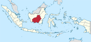
Central Kalimantan is a province of Indonesia. It is one of five provinces in Kalimantan, the Indonesian part of Borneo. It is bordered by West Kalimantan to the west, South Kalimantan and East Kalimantan to the east, Java Sea to the south and is separated narrowly from North Kalimantan and Malaysia by East Kalimantan's Mahakam Ulu Regency. Its provincial capital is Palangka Raya and in 2010 its population was over 2.2 million, while the 2020 Census showed a total of almost 2.67 million; the official estimate as at mid 2022 was 2,741,075.

The Lawa River is a river in East Kalimantan province, Borneo island, Indonesia, about 150 kilometers northwest of Balikpapan. It is a branch of the Mahakam River in eastern Borneo, which is situated entirely within the Kutai Barat, and flows into the Mahakam approximately 200 kilometers (120 mi) upstream from Samarinda. The indigenous communities of Lotaq and Mejaun are situated near its source.

Kumai is a port in Central Kalimantan province in Indonesia, on the island of Borneo. It lies on the Kumai River.

<span class="mw-page-title-main">Kumai River</span> River in Indonesia

The Kumai River is a river of Central Kalimantan province, Borneo island, Indonesia.

<span class="mw-page-title-main">Betung Kerihun National Park</span> National park in Indonesia

Betung Kerihun National Park is a national park located in the Indonesian province of West Kalimantan, on the island of Borneo. The park was established in 1995, and has a total area of 8,000 km2 (3,100 sq mi) or about 5.5 percent of West Kalimantan Province area. Together with the 2,000 km2 (800 sq mi) Lanjak Entimau Wildlife Sanctuary in Malaysia, it has been proposed to form a World Heritage Site named the "Transborder Rainforest Heritage of Borneo".

<span class="mw-page-title-main">Ketapang</span> District in West Kalimantan, Indonesia

Ketapang or Tau-pang in Teochew is the capital city of Ketapang Regency, one of the regencies of West Kalimantan province on the island of Borneo in Indonesia. Ketapang city is located at 1°51′S109°59′E and is a small city on the delta of the Pawan River. Ketapang is served by the Ketapang Airport.

<span class="mw-page-title-main">Sampit</span> Place in Central Kalimantan, Indonesia

Sampit is a large town located in East Kotawaringin Regency, Central Kalimantan. Previously a timber port town, it has grown to be a medium-sized community with a population of 166,773 according to Statistics Indonesia in 2019, with the economy having since divested from timber products. However, the town is not an autonomous city and not an administrative division by despite having a sizeable population and urban built-up. It consists of 11 urban villages (kelurahan) from Baamang District, Seranau District, and Mentawa Baru Ketapang District. The total area of the town is 751.45 square kilometres.

<span class="mw-page-title-main">Kahayan River</span> River in Indonesia

The Kahayan River, or Great Dayak River, is the second largest river after the Barito River in Central Kalimantan, a province of Indonesia in Kalimantan – the Indonesian part of the island of Borneo. With a total length of 658 km (409 mi) and with a drainage basin of 15,500 km2 (6,000 sq mi) in South Kalimantan, Indonesia. Mean annual discharge 1,178 m3/s (41,600 cu ft/s). The provincial capital Palangkaraya lies on the river. The main inhabitants are Dayaks, who practice slash-and-burn rice cultivation and pan for gold on the upper reaches. The lower Kayahan flows through a rich and unusual environment of peat swamp forests, which has been severely degraded by an unsuccessful program to convert a large part of the area into rice paddies, compounded by legal and illegal forestry.

<span class="mw-page-title-main">Tanjung Puting</span> National park in Indonesia

Tanjung Puting National Park is a national park in Indonesia located in the southeast part of West Kotawaringin Regency in the Indonesian province of Central Kalimantan. The nearest main town is the capital of the Regency, Pangkalan Bun. The park is famous for its orangutan conservation.

<span class="mw-page-title-main">Deforestation in Borneo</span>

Deforestation in Borneo has taken place on an industrial scale since the 1960s. Borneo, the third largest island in the world, divided between Indonesia, Malaysia and Brunei, was once covered by dense tropical and subtropical rainforests.

<span class="mw-page-title-main">Pawan River</span> River in Indonesia

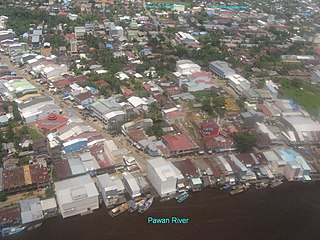
Pawan River is a major river of West Kalimantan, Indonesia. It has a length of 197 kilometres (122 mi). Tributaries include the Keriau River.

<span class="mw-page-title-main">Melawi River</span> River in West Kalimantan, Indonesia

Melawi River is a river in north-western Borneo, Indonesia, about 900 km northeast of the capital Jakarta. It is a tributary of the Kapuas River.

Arut River is a river in the province of Kalimantan Tengah, island of Borneo, Indonesia, about 700 km northeast of the capital Jakarta. It is a tributary of the Lamandau River. The river flows through the north side of Pangkalan Bun town.

<span class="mw-page-title-main">Pembuang River</span> River in Central Kalimantan, Indonesia

Pembuang River or Seruyan River is a river of Borneo, Indonesia. The river has its source near Bikit Tikung in the Schwaner Mountain Range. The eastern side of the river contains dense forest down to Sembulu (Belajau) lakes and is said to be a major habitat of the orangutan. Pembuang means "place of rejection".

<span class="mw-page-title-main">West Kotawaringin Regency</span> Regency of Indonesia

West Kotawaringin Regency is one of the thirteen regencies which comprise the Central Kalimantan Province on the island of Kalimantan (Borneo), Indonesia. It originally comprised the whole western part of the province, but on 10 April 2002 the most westerly districts were split off to form the new Lamandau Regency and Sukamara Regency. The population of the residual part of West Kotawaringin Regency was 235,803 at the 2010 Census and 270,388 at the 2020 Census; the official estimate as at mid 2022 was 274,935. The town of Pangkalan Bun in Arut Selatan District is the capital of West Kotawaringin Regency. The regency has an area of about 10,759 km2.

<span class="mw-page-title-main">Lamandau Regency</span> Regency in Central Kalimantan, Indonesia

Lamandau Regency is a regency of Central Kalimantan province of Indonesia. The regency was created in 2002 from the northwestern parts of West Kotawaringin Regency. The regency has population of 63,119 according to 2010 census and 97,611 based on 2020 census. Population estimate at mid-2022 was 104,387. The regency covers an area of 7,673.56 square kilometers and divided into eight districts (kecamatan). The regency seat is located at the town of Nanga Bulik, which is the regency's economic and administrative center.

<span class="mw-page-title-main">Pangkalan Bun</span> Town in Kotawaringin

Pangkalan Bun is the capital of West Kotawaringin Regency in Borneo, Indonesia. It has a population of around 200,000 It is also the administrative headquarters of South Arut district (kecamatan).

Sekonyer is a river in southern Borneo, Central Kalimantan province, Indonesia, about 700 km northeast of the capital Jakarta.

Mendawai is an Austronesian language spoken along the lower course of the Arut River in West Kotawaringin Regency, Central Kalimantan, Indonesia. It is at the mutually unintelligible end of a dialect continuum with Ngaju. Mendawai and Ngaju share c. 70% of their basic vocabulary.

References

  1. Rand McNally, The New International Atlas, 1993.
  2. Sungai Lamandau at Geonames.org (cc-by); Last updated 17 January 2012; Database dump downloaded 27 November 2015
  3. 1 2 3 H. D. Rijksen; E. Meijaard (1999). Our vanishing relative: the status of wild orang-utans at the close of the twentieth century. Springer. pp. 209–210. ISBN   0-7923-5754-X.
  4. Dalton, Bill (1992). Indonesia. Passport books. p. 279. ISBN   0-8442-9692-9 . Retrieved 1 November 2010.
  5. "Travel New asphalt and old totems". Discover Indonesia Online. Retrieved 1 November 2010.
  6. Backshall, Stephen (2003). The Rough Guide to Indonesia. The Rough Guide to Indonesia. p. 825. ISBN   1-85828-991-2 . Retrieved 1 November 2010.
  7. 1 2 "NASA Earth Observations Data Set Index". NASA. 30 January 2016. Archived from the original on 10 May 2020. Retrieved 11 December 2018.
  8. Peel, M C; Finlayson, B L; McMahon, T A (2007). "Updated world map of the Köppen-Geiger climate classification". Hydrology and Earth System Sciences. 11 (5): 1633–1644. Bibcode:2007HESS...11.1633P. doi: 10.5194/hess-11-1633-2007 .
  9. "NASA Earth Observations: Rainfall (1 month – TRMM)". NASA/Tropical Rainfall Monitoring Mission. 30 January 2016. Archived from the original on 19 April 2019. Retrieved 11 December 2018.
  10. Brown, Alfred Reginald Radcliffe-; Raymond Firth; Adolphus Peter Elkin (1946). Oceania: a journal devoted to the study of the native peoples of Australia, New Guinea, and the islands of the Pacific Ocean, Volumes 16–17. University of Sydney. p. 95. Retrieved 1 January 2010.
  11. "Support sustainable forest management in Borneo". National Geographic Global Action Atlas. Archived from the original on 18 July 2012. Retrieved 30 October 2010.
  12. "Lamandau Nature Reserve: An Orangutan Release Site". Orangutan Foundation International. Archived from the original on 26 July 2011. Retrieved 1 November 2010.

2°51′20″S111°43′14″E / 2.85556°S 111.72056°E / -2.85556; 111.72056